St. Sennen’s Well, Sennen Cove, Cornwall

Holy Well (lost):  OS Grid reference – SW 3550 2626

Archaeology & History

The springs of Chapel Idne

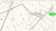
Highlighted on the 1888 Ordnance Survey map of Sennen Cove are the remains of Chapel Idne, just above the coast.  Across the road from the chapel on its south-side, and also next to an old inn to its immediate west, springs of water are shown and it would seem more than likely that one of these two would have been the forgotten holy well of Sennen that was described, albeit briefly, in the great Mr Blight’s (1861) literary tour of the area.  He told us that:

“At Sennen Cove was an ancient chapel, called by the people Chapel Idne, the “narrow chapel” being forty-five feet long and fifteen feet wide.  It is now converted into a dwelling. Tradition says it was founded by one Lord of Goonhilly, who possessed dome portion of the land of Lyonesse.  There was a holy well of some repute here also.”

The waters of St. Sennen’s Well were used in an act of ceremonial magick in the Arthurian tale known as the Battle of Vellan-druchar, as told in Robert Hunt’s (1865) great Romances.  An attempted invasion by the Danes was met with by Arthur and nine other kings and the foreigners were slaughtered.

“A few had been left in charge of the ships, and as soon as they learned the fate of their brethren, they hastened to escape, hoping to return to their own northern land. A holy woman, whose name has not been preserved to us, “brought home a west wind” by emptying the Holy Well against the hill, and sweeping the church from the door to the altar.  Thus they were prevented from escaping, and were all thrown by the force of a storm and the currents either on the rocky shore, or on the sands, where they were left high and dry.  It happened on the occasion of an extraordinary spring-tide, which was yet increased by the wind, so that the ships lay high up on the rocks, or on the sands; and for years the birds built their nests in the masts and rigging.

Thus perished the last army of Danes who dared to land upon our western shores.

King Arthur and the nine kings pledged each other in the holy water from St Sennen’s Well, they returned thanks for their victory in St Sennen’s Chapel, and dined that day on the Table-men.

Merlin, the prophet, was amongst the host, and the feast being ended, he was seized with the prophetic afflatus, and in the hearing of all the host proclaimed–

“The northmen wild once more shall land,
And leave their bones on Escol’s sand.
The soil of Vellan-Druchar’s plain
Again shall take a sanguine stain;
And o’er the mill-wheel roll a flood
Of Danish mix’d with Cornish blood.
When thus the vanquish’d find no tomb,
Expect the dreadful day of doom.”

References:

  1. Blight, J.T., A Week at the Land’s End, Longmans Green: London 1861.
  2. Hunt, Robert, Popular Romances of the West of England, 1865.
  3. Straffon, Cheryl, “Chapel Idne and the Holy Well,” in Meym Mamvro no.34, 1997.
  4. Weatherhill, Craig, “A Guide to Holy Wells and Celebrated Springs in West Penwith,” in Meym Mamvro no.4, 1997.

Acknowledgements:  Big thanks for use of the early edition OS-map in this site profile, Reproduced with the kind permission of the National Library of Scotland

© Paul BennettThe Northern Antiquarian

Mineral Well, Upper Norwood, Surrey

Healing Well (destroyed):  OS Grid Reference – TQ 318 703

Archaeology & History

This was one of several so-called mineral springs in and around the Norwood area, but seemingly the least well-known—certainly in literary terms.  Whatever renown it may once have had was overwhelmed by the relative proximity of the much more famous curative waters of the Beulah Spa, a few hundred yards to the southeast.  It was mentioned, albeit briefly and already in the past tense, in John Anderson’s (1898) survey, when he told that “There used to be (a) mineral well at Biggin Hill. It is marked on the Croydon Inclosure Map” of 1800 and shown as a “Spring”, north of Biggens Farm.  It seems that it had only just been destroyed when Anderson wrote about it, as the research of Alfie Foord (1910) showed. His inquiries found that,

“There used to be another mineral well about half a mile to the north-west of Beulah Spa, at Biggin Hill, the water from which gushed up at the rate of seven gallons a minute.  In 1898 it was closed.  The subjoined analysis of water from a well, which is at White Lodge, Biggin Hill, formerly the residence of Mr. H. Wilson Holman, was kindly supplied by him to the writer in 1907.  This well, he says, undoubtedly taps the same spring that used to come out at the bottom of Biggin Hill, and which was blocked by the sanitary authorities in 1898.  The site of the spring was beyond the small tenement houses at the bottom of the hill, and there is still some masonry in existence—the end of the culvert where the water used to run out into a pond.  The reason of its being blocked was that it is alleged to have poisoned some domestic animal.”

References:

  1. Anderson, John C., The Great North Wood, Blades: London 1898.
  2. Foord, Alfred Stanley, Springs, Streams and Spas of London: History and Association, T. Fisher Unwin: London 1910.
  3. Gover, J.E.B., Mawer, A. & Stenton, F.M., The Place-Names of Surrey, Cambridge University Press 1934.

© Paul BennettThe Northern Antiquarian

Maiden’s Well, Launceston, Cornwall

Holy Well (destroyed):  OS Grid reference – SX 3285 8477

Archaeology & History

Site of well on 1884 map

Very little is known about this holy well on the north-western side of town that was apparently destroyed sometime in the 19th century; for when the Ordnance Survey lads visited here in 1882, they found no running water but only the location of where it had been and they indicated this on their 1884 map of the area, marked as “Site of.”

It was first mentioned in a short topographical notice in 1582, which told that the “Magden Well in the Quarrie Haye”—along with another well—was “found to be in decay.” (Peter 1885)  Then, when the Ordnance Survey lads resurveyed the area again in 1951, once more they could find no trace of it.

References:

  1. Peter, Richard, The Histories of Launceston and Dunheved, W. Brendon: Plymouth 1885.

Acknowledgements:  Big thanks for use of the early edition OS-map in this site profile, Reproduced with the kind permission of the National Library of Scotland

© Paul BennettThe Northern Antiquarian

Holy Well, Lawhitton, Cornwall

Holy Well:  OS Grid reference – SX 3546 8252

Archaeology & History

Site shown on 1882 OS-map

Highlighted on the 1882 OS-map several hundred yards north of St. Michael’s church, this site seems to have fallen back to Earth as no remains of it have been found in recent visits.  It was described in Charles Henderson’s (1914) notes as the “holy well at Barton Farm”, and was visited by J. Meyrick (1982) in April of 1980, who told that it could be found by taking “the track immediately east of Lawhitton church which runs through the farm of Mr Lancaster…  After going through the yard proceed ¼ mile down track to the valley where you reach a stream and the Well is on the right.”  It was sought after by Cheryl Straffon (1998) but following her visit to find the Well she told that “there was nothing now to see except a kind of natural basin by the small bridge.”

References:

  1. Henderson, Charles, Notebooks of Parochial Antiquities, Unpublished MS 1914.
  2. Meyrick, J., A Pilgrims Guide to the Holy Wells of Cornwall, Falmouth 1982.
  3. Straffon, Cheryl, Fentynyow Kernow: In Search of Cornwall’s Holy Wells, Meyn Mamvro: Penzance 1998.

Acknowledgements:  Big thanks for use of the early edition OS-map in this site profile, Reproduced with the kind permission of the National Library of Scotland

© Paul BennettThe Northern Antiquarian

Scout Willie’s Well, Idle, Bradford, West Yorkshire

Healing Well (destroyed):  OS Grid Reference –SE 1672 3866

Archaeology & History

Along the footpath below the family graveyard at Thackley, the great genealogist and industrial historian J.H. Turner (1878) told that, “at the right hand side of the wood, at the bottom, is Scout Willie’s Well, formerly noted for its medicinal properties” – though whatever curative aspects it possessed have long since been forgotten.  It was also known as the Sweet Willie Well.  I perused the woodlands here searching for the well in my younger days but could find no trace of it; nor is anything shown on the early OS-maps of the area.  

References:

  1. Turner, J. Horsfall, Idle Upper Chapel Registers and Graveyard Inscriptions, Bingley 1878.

© Paul BennettThe Northern Antiquarian

Organn Well, Pontefract, West Yorkshire

Healing Well (destroyed):  OS Grid Reference – SE 45 21

Archaeology & History

The waters of the once-renowned Organn Well goes down in history as being one of the first wells in Britain whose waters were used in a town pump.  Written minutes from an early council meeting described how people gathered in the market place to discuss the objective of making such a pump in the times of Queen Elizabeth 1, in 1571.  It was completed a year later and, some 450 years on, this old relic can still be seen.  The Well used to be found off Penny Lane (now Wakefield Road), some 4-500 yards to the southwest and as such it’s exact position has been difficult to locate.  But the fact that the waters were piped such a distance strongly suggests that the water supply from the Well was damn good – and most probably damn refreshing too!  The old charter told us, in that wonderfully dyslexic manner of the period,

…that a conduit in the Markett Place with lead pipes leading to water from Organ Well to the said conduit shall bee cleansed and repayred at the charge and contribution of severall inhabitants of the Towne and espetially by those that fetch water from the same conduit. And according to the auncient custome of the said Towne, whoe shall not beare theire p’t of the chardge p’portionable to what water they from the same at the discretion of the Majo’ for the time being and his brethren shall be debarred from the benefitt of the said conduit except they shall be poore people.  And likewise that none shall receive any water from the said conduite for to brewe or steep barley w’thall at such time or times as others have need the same for meat water and water to washe w’hall, but onely at such times as there is water to spare over and besides what is convenient for meat and washing.”

More than two hundred years later the water pump was in dire need of attention, as George Fox (1827) told:

“Being in a ruinous state about the year 1810 and the supplies of water being insufficient for the public use; a clause was inserted in the act of parliament… wherein the pump, its pipes, and all other appurtenances belonging to it were vested in the power of the commissioners of the streets, who where bound to see it kept in proper repair.”

And so the water from the Organn Well continued to supply the townsfolk.

The etymology of this well—along with another of the same name near Harrogate—truly puzzled me for a long time; that was until I came across, quite by accident, records from early texts on herbalism.  As a result, it seems very likely that it derives its name from the old English ‘organe,’ which, according to Stracke (1974) and others relates to both varieties of the indigenous herb marjoram (Origanum vulgare and O.marjorana) — a grand medicinal plant that’s pretty common in northern England (I used to go out gathering it each year in my younger days).  There were obviously profuse supplies of this herb growing in and around the well and, as all good herbalists will tell you, when they grow by an old spring or well, their medicinal properties are much better than normal.  The waters and the plant obviously had a good symbiosis; or, as the old women who’d collect the waters and the herbs in days prior to the pump would have told us, “the spirits of the water here are good”…

References:

    1. Fox, George, The History of Pontefract in Yorkshire, J.Fox: Pontefract 1827.
    2. Padgett, Lorenzo, Chronicles of Old Pontefract, Oswald Homes: Pontefract 1905.
    3. Stracke, J. Richard (ed.), The Laud Herbal Glossary, Rodopi: Amsterdam 1974.

© Paul BennettThe Northern Antiquarian

St. Helen’s Well, Hartlepool, Durham

Holy Well (destroyed):  OS Grid Reference – NZ 5236 3421

Also Known as:

  1. Freemen’s Well

Archaeology & History

Highlighted on the 1861 OS-map of the area, there is a curious lack of reference to this holy well until Cuthbert Sharp wrote about it in 1816.  Records of an adjacent St. Helen’s Chapel are in plentiful supply, going all the way back to around 1200 CE—although it’s pretty obvious that a water supply would be attached to the chapel, despite its late literary account.   Sharp told us:

“This chapel is stated to have been on the warren.  According to local tradition, a church once stood near the Freemen’s or St. Helen’s Well, in the Far-well Field, where the ground at present is considerably elevated, and where many hewn stones are constantly discovered, which renders it highly probable that this was the site of the chapel in question.”

Site shown on 1861 OS map
Site on the 1862 Town plan

When Robert Surtees visited here in 1823, the well was still visible, but remains of the chapel were negligible.  On the 1862 Hartlepool Town map, it would seem that a construction—perhaps a well-house—covered the waters, although whatever it may have been seems to have been destroyed sometime in the 1880s, when the entire area was built over.  No remains of this sacred site have been seen since.

References:

  1. Cuthbert Sharp, A History of Hartlepool, Francis Humble: Durham 1816.
  2. Surtees, Robert, The History and Antiquities of the County Palatine of Durham (4 volumes), London 1816-40.

Acknowledgements:  The map accompanying this site profile is Reproduced with the kind permission of the National Library of Scotland

© Paul BennettThe Northern Antiquarian

St. Ann’s Well, Welton, East Yorkshire

Holy Well:  OS Grid Reference – SE 9622 2709

Archaeology & History

Shown on the early 25-inch-to-the-mile Ordnance Survey map of the area, this is a frustrating site.  In Thompson’s (1870) early history of Welton village, he says very little about this place, other than:

“Then there is Saint Ann’s Well, which supplies Welton House with spring water.”

Site shown on 1890 map

Even worse is the fact that in William Smith’s (1923) survey of East Yorkshire holy wells, he merely copies Thompson; and in Jeremy Harte’s magnum opus he does exactly the same thing!  Not good.  Thankfully the local artist and singer, Gaynor Perry, helped us out big time!  She grew up in this area and used to play here when she was young, but at the time she had no idea that the well where she’d played had any magical traditions attached to it.  This discovery happened many years later.  Regarding the present condition of the well (as of 2017), she told:

“The well has been covered with stone slabs for a long time (and) a tree has tried to grow over it.  It has been sheltered here over the years in the grounds of Welton House, a large estate which was demolished in 1952.”

The well can still be seen in the small copse of trees immediately north of St Anne’s College.  There is the possibility that this holy well gave its name to the village of Welton itself.  First mentioned in 1080 CE, the place-name means “the well near the farm,” (Smith 1937) although there is no direct linguistic association with St. Anne, so we don’t know for sure.

Folklore

St. Anne is a curious saintly figure and one of my personal favourites.  St Anne (saint’s day – July 26) was a giant in early christian and Islamic myths.  An apocryphal figure, She was the Great Mother of the mother of Christ—the Virgin Mary—and was Herself a Virgin until, in Her old age, after seeing a bird feeding a chick, decided She wanted a child and so eventually gave birth to Mary.  An old woman giving birth when the Springtime appears (when birds and other animals become fertile) is the same motif found in the lore of the Cailleach in Ireland and Scotland (and parts of northern England).  A pre-christian mythos was obviously at play here in bygone times…

References:

  1. Harte, Jeremy, English Holy Wells – volume 2, HOAP: Wymeswold 2008.
  2. Smith, A.H., The Place-Names of the East Riding of Yorkshire and York, Cambridge University Press 1937.
  3. Smith, William, Ancient Springs and Streams of the East Riding of Yorkshire, A. Brown: Hull 1923.
  4. Thompson, Thomas, Researches into the History of Welton and its Neighbourhood, Leng & Co.: Kingston-upon-Hull 1870.

Links:

  1. Gaynor Perry:  St Anne’s Well

© Paul BennettThe Northern Antiquarian

Holy Well, Nether Heyford, Northamptonshire

Holy Well (lost):  OS Grid Reference – SP 66 59 (approximate)

Archaeology & History

In George Baker’s (1822) massive regional history work he spoke of the village being “well supplied with springs, one of which, called Holywell, is medicinal.”  But it would seem to have fallen foul of that thing called progress, as no one has spoken of it since then.  When the Northampton historian, Beeby Thompson, looked for the site early in the 20th century, his enquiries drew a blank and he reported simply that “at the present time no one in the village appears to know of such a well.”  A field-name survey of the area may prove worthwhile…

References:

  1. Baker, George, The History and Antiquities of the County of Northampton, J.B. Nichols: London 1822.
  2. Harte, Jeremy, English Holy Wells – volume 2, HOAP: Wymeswold 2008.
  3. Thompson, Beeby, “Peculiarities of Waters and Wells,” in Journal Northamptonshire Natural History Society, volume 17, 1914.

© Paul BennettThe Northern Antiquarian

St. Ann’s Well, Harrogate, North Yorkshire

Holy Well (lost):  OS Grid Reference – SE 298 548

Archaeology & History

Very little is now known about this sacred site that was once found “a few hundred yards east from the New Church at Low Harrogate.” (Hunter 1830)  Even most of travellers and medical experts who wrote about the numerous Harrogate wells in the 18th and 19th century bypassed its quietude; and by the time Mr Hunter wrote about it in his great descriptive catalogue, its healing or medicinal qualities had been forgotten.

He told that “the spirit in the water…or that with which it is infused, has long been most actively engaged in adding real or fancied comforts to the (Harrogate) Fair, and is now in much more general use” than the two other holy wells in the town. It was, he said, “the best water for making tea and more extensively used for that purpose than any in the neighborhood of Harrogate.”  It would also appear to have been built over at some time in the not-too-distant past…

Folklore

St Ann (saint’s day – July 26) was a giant in early christian and Islamic myths.  An apocryphal figure, She was the Great Mother of the mother of Christ—the Virgin Mary—and was Herself a Virgin until, in Her old age, after seeing a bird feeding a chick, decided She wanted a child and so eventually gave birth to Mary.  An old woman giving birth when the Springtime appears (when birds and other animals become fertile) is the same motif found in the lore of the Cailleach in Ireland and Scotland (and parts of northern England).  Pre-christian lore at this old well would seem evident here.

References:

  1. Hunter, Adam, The Waters of Harrogate and its Vicinity, Langdale: Harrogate 1830.

© Paul BennettThe Northern Antiquarian