Stob Cross, Markinch, Fife

Wayside Cross: OS Grid Reference – NO 29607 02202

Also Known as;

  1. Stobb Cross
  2. Canmore ID 29950

Getting Here

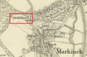
Shown on 1856 OS map

The cross is located on a bluff of land overlooking the west side of Stob Cross Road on the northern edge of Markinch.

Archaeology & History

In 1933, following a visit in 1925, the county archaeological inventory described it thus:-

Close beside the East Lodge of Balbirnie House, on a knoll 200 feet above sea-level, stands a stone known, from the nature of its sculpturings, as the “Stob Cross.” It is a somewhat mutilated rectangular slab, 7 feet 5 ½ inches in height, 2 feet broad at the base and 6 inches thick, having a plain cross carved in relief on the east and on the west face. The cross on the east is now very much damaged but sufficient remains to indicate that the arms have been 1 foot wide and that the shaft has measured 1 foot 5 inches across at the intersection. On the west face the design stands out in relief from 1 to 1 ¼ inches. The arms of the cross measure 11 ½ inches in width, and the upper limb, which tapers slightly to its extremity, is 12 ½ inches across at the point of intersection. The shaft measures 1 foot 2 inches across below the arms and widens gradually downwards to 1 foot 8 inches at the base. In 1790, when the cross was in danger of falling, the Earl of Leven had the position faced up with masonry, and the monument now stands, with its major axis north and south, on a two-stepped base of modern construction.
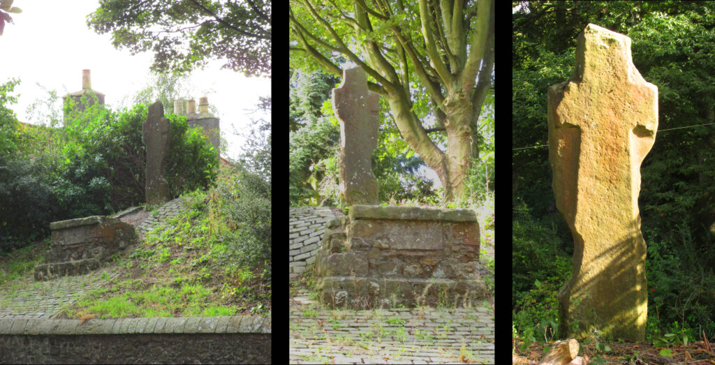
Roadside views l. & centre – Rear view r.

It’s certainly had a hard life, and its official designation as ‘early medieval’ leads us to suspect that it may have been a decorated Pictish cross that has had its ornamentation obliterated by Reformation iconoclasts. Those same iconoclasts may have concocted the ‘history’ recounted by Rev  John Thomson (1794) in the Old Statistical Account of 1794 of what he describes as a ‘very coarse piece of work’:-

‘Vulgar tradition says, that it was erected to the memory of a gentleman, who fell on this spot, in a mortal encounter with one of his neighbours.’

Writing of Markinch, nineteenth century historian Aeneas Mackay (1896) has this to say:-

‘A cell of the Culdees was established there by one of the last Celtic bishops, and the ancient cross near Balgonie [sic] may mark its site.’

Modern place-name research ascribes Markinch as a place where horses were grazed while their owners were attending the early mediaeval courts and assemblies at Dalginch a quarter of a mile to the east, so the cross may at that time have been a waymarker. A roadside plaque describes the Cross as possibly marking the limit of an ancient sanctuary enclosure related to the church of St Drostan (known locally as St. Modrustus) in the centre of Markinch.  Additionally, it was on the ancient (and recently revived) Fife Pilgrim Way from Culross to St Andrews, so would have been a wayside station for the pilgrims. which if it was a Pictish cross would have made it a target for desecration by iconoclasts. We are lucky that it has survived at all, and with the revival of the Pilgrim Way as a long distance path it will attract many new admirers.

References:

  1. Forbes, A.P., Kalendars of Scottish Saints, Edmonston & Douglas: Edinburgh 1872.
  2. Mackay, Aeneas J.G., A History of Fife and Kinross, Blackwood: Edinburgh 1896.
  3. Markinch Heritage Group, – http://www.markinchheritage.org.uk/Index.asp?MainID=5250
  4. Royal Commission, Inventory of Fife, Kinross & Clackmannan, HMSO: Edinburgh 1933.
  5. Taylor, Simon & Márkus, Gilbert, The Place Names of Fife – volume 2, Shaun Tyas: Donnington 2013.
  6. Thomson, Rev John. The Statistical Account of Scotland – volume 12, Creech: Edinburgh 1794.

© Paul T. Hornby, The Northern Antiquarian, 2020


Balbirnie Stone Circle, Markinch, Fife

Stone Circle: OS Grid Reference – NO 28585 02968

Also Known as:

  1. Balfarg Stone Circle
  2. Druid’s Circle

Getting Here

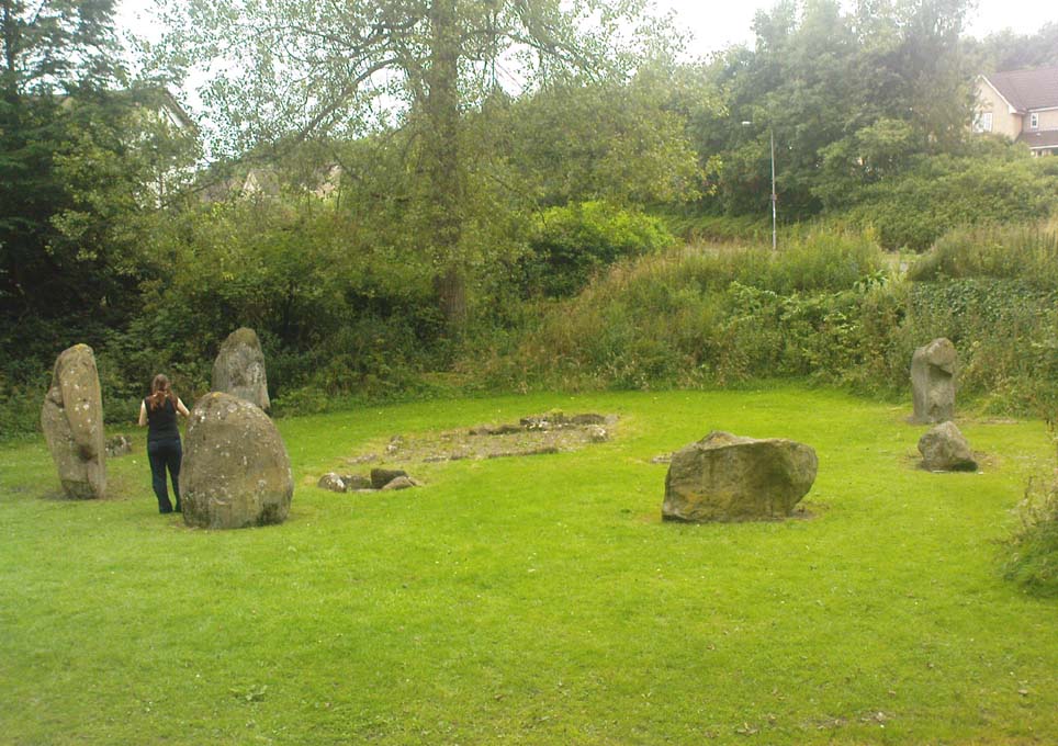
Balbirnie stone circle – with Marion checking it out!

Take the A92 road running north out of Glenrothes towards Freuchie and, after a couple of miles out of town, you’ll hit the B969 road on your left.  Across from here on the other side of the road, you’ve just passed a small B-road that takes you to Markinch.  That’s where you need to be!  Go along there for less than 100 yards and turn first right, swerving along the tree-lined road for 200 yards or so. Watch out, just before the first house on your left, for a footpath which leads into the woods. Walk down it, barely 10 yards!

Archaeology & History

This is a lovely megalithic ring in a lovely setting – albeit a new one. The circle was originally positioned some 125 yards northwest of here and would have been destroyed, but was thankfully reconstructed by Fife Council before road-widening of the A92 was done. And the job’s a good one! But as Burl (2005) tells, this wasn’t the first time Balbirnie had been threatened with damage:

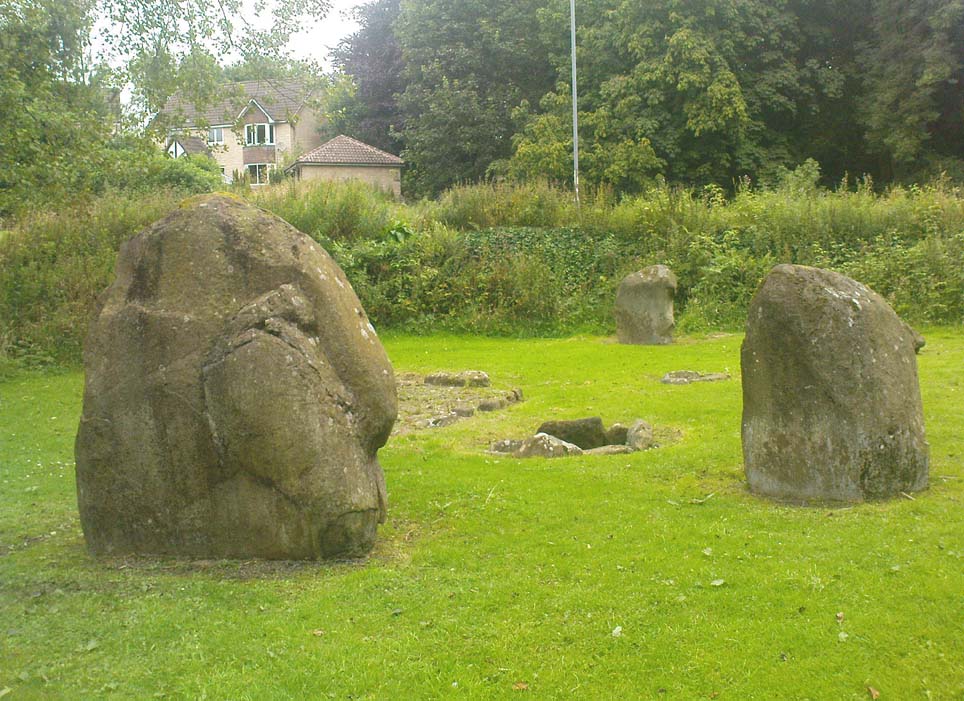
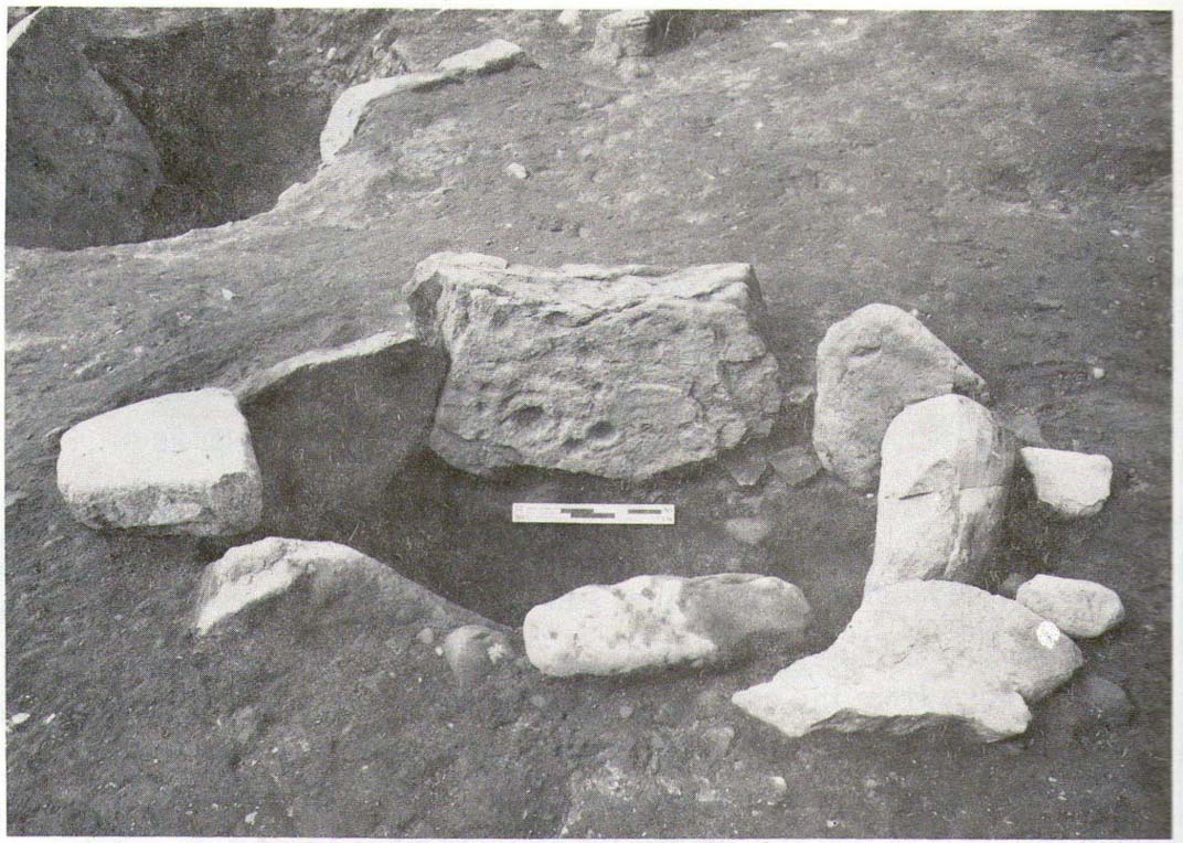
The southeastern stones & cists
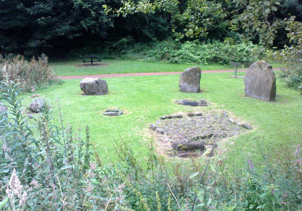
Balbirnie from the roadside, looking southeast

“With some stones removed in the eighteenth century, dug into in 1883 when bones and sherds were found, damaged by trees, it was finally excavated and restored in 1970-71,” before the main road was built. Thankfully it’s still here – and an excellent stone circle it is! However, the reconstructed site here doesn’t show the circle in its entirety. Originally there were ten standing stones making up the ring, as opposed to the seven you can see today.

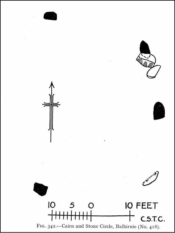
Royal Commission ground-plan, c.1933

The site was built amidst the scatter of other larger, and once more impressive, mythically important monuments than the circle – but it’s as likely that the circle added more to the sacred dimensions of the region as a whole when it first came to be built. For on the other side of the A92 we can still see the denuded remains of the Balfarg Riding School Henge, with imitations of its internal upright posts resurrected into position to give an idea of what once stood inside the sacred enclosure. And then about 200 yards west of that, the gigantic Balfarg Henge is impressively surrounded by a modern housing estate, built with the henge in mind, with its outlying megaliths and internal level surface area graciously intact. It’s a truly impressive prehistoric area all round, although the Balbirnie stone circle was built some considerable time after the two henges had been done, many centuries later…

Before the circle was moved, the consensus profile of the site was that given by the Royal Commission (1933) lads following their visit here in June 1925, when they told it looked like this:

“At the southern end of a small wood on the east side of the main road from Kirkcaldy to Falkland, about 180 yards south of Balbirnie Lodge, are the remains of a large circular cairn and of the setting of standing stones by which it was once surrounded… The circle, which has had a diameter of some 48 feet, has been composed of sandstone boulders. Four of these are still in place, but one other on the southeast has been slightly displaced, while against the stone on the northeast lie two large boulders, which apparently have been transferred to this position. Any other stones that may once have existed have been removed or destroyed. The greatest height above ground of any of those that survive is 5 feet 6 inches, while one, which rises no more than 2 feet, measures in circumference as much as 9 feet 9 inches at the base. The cairn itself seems to have been broken into at two points. No record of these excavations appears to be extant, but a number of fragments of cinerary urns from the site are preserved in the National Museum. These indicate that, as might have been inferred from its general character, the monument was sepulchral and dates from the Bronze Age.”

Sepulchral indeed. When the stone circle was excavated at the beginning of the 1970s by J.N.G. Ritchie (1974) and his mates, it was discovered this was a primary function of the site. As Burl (2000) wrote:

“At Balbirnie patches of cremated bone lay underneath some circle-stones. Whatever the ceremonies here they were interrupted when the site was converted into a cemetery. Four or five cists associated with a late beaker and a jet button were constructed within the ring. The date of about 1650 BC came from wood alongside the beaker. Stretches of low walling were put up between the stones forming a continuous barrier…analogous to the embanked stone circles elsewhere in Britain that seem generally to belong to a period in the mid-second millennium… But the first cists did not long remain undisturbed and were seemingly rifled when later cists were built that contained the cremations of women and children… One of these later cists held a food-vessel and a flint knife.

“The stone circle was further abused. A low cairn was piled over all the cists. Sherds of deliberately broken urns, one with barley impressions, were scattered amongst the boulders, intermingled with small coagulations of burnt human bone. This last phase at Balbirnie occurred late in the second millennium BC, for a C-14 determination of…1200 to 900 BC came from the land surface that had built up within the ring during the centuries while the stone circle remained open to the weather.”

Measuring 49 feet across at the widest, this flattened ellipse also possessed a curious rectangular section of laid stone, near the middle of this circle, almost ‘Roman-road’ like in appearance and covering about a quarter of the internal arena. It’s visible today at the reconstructed site and looks almost intrusive! Measuring some 11 feet by 9 feet, the flat stone surface has been suggested as a place where corpses were rested.

Also found within two of the tombs inside the circle were the cup-and-ring marked stones of Balbirnie 1 and Balbirnie 2, showing yet again the relationship that some of these carvings have with spirits of the dead.

…to be continued…

References:

  1. Burl, Aubrey, “Intimations of Numeracy in the Neolithic and Bronze Age Societies of the British Isles (c.3200-1200 BC),” in Archaeological Journal, volume 133, 1976.
  2. Burl, Aubrey, Rings of Stone, BCA: London 1979.
  3. Burl, Aubrey, The Stone Circles of Britain, Ireland and Brittany, Yale University Press 2000.
  4. Burl, Aubrey, A Guide to the Stone Circles of Britain, Ireland and Brittany, Yale University Press 2005.
  5. Denston, C.B., “The Cremated Remains from Balbirnie, Fife,” in Archaeological Journal, volume 131, 1974.
  6. Ritchie, J.N.G., “Excavation of the Stone Circle and Cairn at Balbirnie, Fife,” in Archaeological Journal, volume 131, 1974.
  7. Royal Commission on the Ancient & Historical Monuments, Scotland, Inventory of Monuments and Constructions in the Counties of Fife, Kinross and Clackmannan, HMSO: Edinburgh 1933.

AcknowledgementsHuge thanks to Marion Woolley for getting us out to see this and the related neolithic monuments.  Cheers m’ dears!

© Paul Bennett, The Northern Antiquarian


Balbirnie Carving (01), Markinch, Fife

Cup-and-Ring Stone: OS Grid Reference – NO 28587 02966

Also Known as:

  1. Balfarg
  2. Fif 1 (Morris 1981)

Getting Here

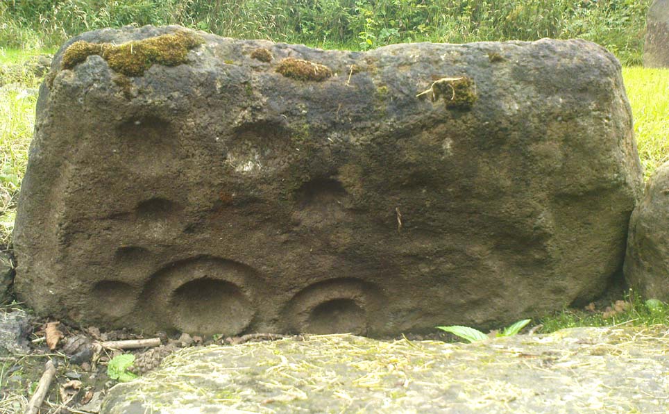
The cup-and-ring marked slab

Follow the same directions to find the Balfarg Stone Circle.  From the A92 going north from Glenrothes, turn E onto the country lane to Star and Kennoway. 100 yards on there’s a sign for Balbirnie; turn right here and about 200 yards on, where the road bends right, the circle’s just below you). This carving is perched on its side in one of the preserved grave cists within the circle, easily visible at ground level.

Archaeology & History

This carving (and its adjacent compatriot) was found inside the Balbirnie stone circle when it stood in its original position more than 100 yards northwest of the place it presently occupies (at NO 2850 0304). Thankfully, when the megalithic ring was moved and reconstructed, its original status was kept, including the repositioning of this impressive small cup-and-ring stone – despite it being a copy of the original.

Early photo of the carving

Like a good number of prehistoric tombs, this small carved stone was stood on edge, facing into the stone-lined tomb (cist), obviously representative of some important element in the Land of the Ancestors: perhaps a map of the landscape therein; perhaps a personal token; perhaps indicative of the spirits of the dead; perhaps a magickal amulet for safe guidance. There are a number of ritual possibilities here, and whichever it was, we can be sure the symbols were representative of the animistic cosmology of the neolithic people living hereby, linking the living with the dead.

As you can see from the original photograph, a number of cup-marks along the edges of the stone are accompanied by two or three cup-and-rings, one of which is very faint. Some carved lines run between some facets of the carving, linking one mythic element to another. Ron Morris (1981) described the carving, simplistically, as,

“Under a cairn, within a ring of stones, one of 5 cists had, carved on the inside of a side-slab (sandstone), ¾m by ½m by ¼m (2¾ft x 1¾ft x ¾ft): 2 cups-and-one-ring—one faint and incomplete—and also 8 cups, 2 with ‘tails’. Greatest diameter of ring 12cm (5in), and carving depths up to 2cm (1in).”

References:

  1. Burl, Aubrey, Rings of Stone, BCA: London 1979.
  2. Morris, Ronald W.B., The Prehistoric Rock Art of Southern Scotland, BAR: Oxford 1981.

© Paul Bennett, The Northern Antiquarian


Balbirnie Carving (02), Markinch, Fife

Cup-and-Ring Stone: OS Grid Reference – NO 2850 0304

Also Known as:

  1. Balfarg
  2. Fif 1b (Morris 1981)

Getting Here

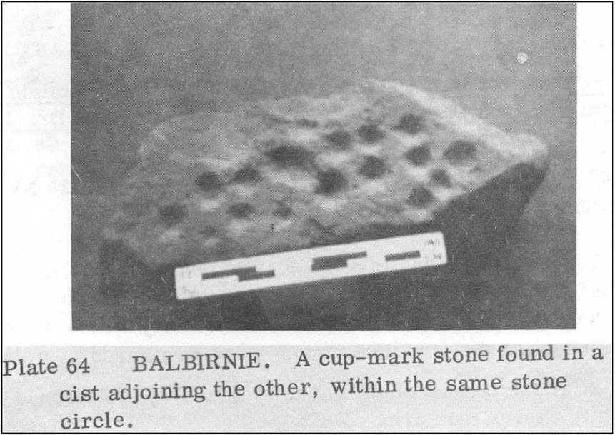
Old photo of the Balbirnie 2 carving

This carved stone is now held in one of the museums. To get a better idea of its original locale, take the directions to reach the Balfarg Stone Circle (from the A92 going north from Glenrothes, turn E onto the country lane to Star and Kennoway. 100 yards on there’s a sign for Balbirnie; turn right here and about 200 yards on, where the road bends right, the circle’s just below you) and look at the small stone-lined tombs (cists), within which this carving was first found.

Archaeology & History

This carving (and its adjacent compatriot) was first found within the Balfarg stone circle that originally stood more than 100 yards northwest of the site it now occupies (at NO 2850 0304). Found inside the edge of another prehistoric stone-lined tomb (cist) within the stone circle, the small elongated stone possessed at least 16 singular cup-marks along one flat face of the rock. Two adjacent cup-marks may be linked by a small line running between them. As you can see in the old photograph here, most of the cups run in two parallel lines, similar to the primary feature found on the more famous Idol Stone on Ilkley Moor.

Described in association with the Balbirnie 1 carving by Ronald Morris (1981) as simply, “a slab in another cist (with) cup-marks,” like its partner just a few yards away this carving was again representative of some important mythic element in the Land of the Dead to the person whose body was laid here.

References:

  1. Morris, Ronald W.B., The Prehistoric Rock Art of Southern Scotland, BAR: Oxford 1981.

© Paul Bennett, The Northern Antiquarian