Little Almscliffe, Stainburn, North Yorkshire

Cup-and-Ring Stone:  OS Grid Reference – SE 23242 52260

Also Known as:

  1. Little Almes Cliffe
  2. Little Almias Cliff Crag

Archaeology & History

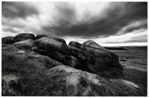
Little Almscliffe Crag (photo by James Elkington)

The crags of Little Almscliffe are today peppered with many modern carvings, such as are found on many of our northern rock outcrops.  Yet upon its vertical eastern face is a much more ancient petroglyph – and one that seems to have been rediscovered in the middle of the 20th century.  When the great northern antiquarian William Grainge (1871) visited and wrote of this place, he told us that, “the top of the main rock bears…rock basins and channels, which point it out as having been a cairn or fire-station in the Druidic days; there are also two pyramidal rocks with indented and fluted summits on the western side of the large rock” – but he said nothing of any prehistoric carvings. Curiously , neither the great historian Harry Speight or Edmund Bogg saw anything here either.

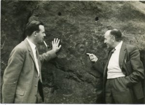
Stuart Feather & Joe Davies here, c.1955
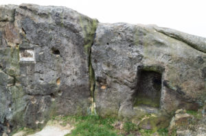
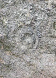
Cup&Ring, left of ‘door’ (photo by James Elkington)

This singular cup-and-ring design seems to have been reported first in E.S. Wood’s (1952) lengthy essay on the prehistory of Nidderdale. It was visited subsequently by the lads from Bradford’s Cartwight Hall Archaeology Group a few years later; and in the old photo here (right) you can see our northern petroglyph explorer Stuart Feather (with the pipe) and Joe Davis looking at the design.  In more recent times, Boughey & Vickerman (2003) added it in their survey of, telling briefly as usual:

“On sheltered E face of main crag above a cut-out hollow like a doorway is a cup with a ring; the top surface of the rock is very weathered and may have had carvings, including a cupless ring.”

Close up of design

Indeed… although the carving is to the left-side of the large hollow and not above it.  Scattered across the topmost sections of the Little Almscliffe themselves are a number of weather-worn cups and bowls, some of which may have authentic Bronze age pedigree, but the erosion has taken its toll on them and it’s difficult to say with any certainty these days.  But it’s important to remember that even Nature’s ‘bowls’ on rocks was deemed to have importance in traditional cultures: the most common motif being that rain-water gathered in them possessed curative properties.

References:

  1. Bennett, Paul, The Old Stones of Elmet, Capall Bann: Milverton 2001.
  2. Bogg, Edmund, From Eden Vale to the Plains of York, James Miles: Leeds 1895.
  3. Bogg, Edmund, Higher Wharfeland, James Miles: Leeds 1904
  4. Cowling, E.T., Rombald’s Way, William Walker: Otley 1946.
  5. Grainge, William, History & Topography of Harrogate and the Forest of Knaresborough, J.R. Smith: London 1871.
  6. Parkinson, Thomas, Lays and Leaves of the Forest, Kent & Co.: London 1882.

Acknowledgements:  Huge thanks to James Elkington for use of his fine photos on this site.

© Paul BennettThe Northern Antiquarian

Lady Well, Airth, Stirlingshire

Holy Well (destroyed):  OS Grid Reference – NS 89801 86524

Also Known as:

  1. Canmore ID 46862
  2. Lady’s Well
  3. Spaw Well

Archaeology & History

Site of the Lady Well, Airth

Once to be seen flowing on the south-side of the Pow Burn below Airth Castle, all traces of this once sacred site has fallen prey to the usual advance of the so-called ‘civilized’.  In literary terms, the site was first described in church records from 1657—as Ladieswell—and the accounts we have of the place from then are most revealing in describing the traditional use of the place by local people.  It was a sacred site, obviously, chastised by the madness of the christian regime of the period, in their attempt to destroy indigenous customs and societal norms.  William Hone (1837) gave an extended account of what some people were up to here in his Everyday Book:

“In 1657, a mob of parishioners were summoned to the session, for believing in the powers of the well of Airth, a village about six miles north of Falkirk, on the banks of the Forth, and the whole were sentenced to be publicly rebuked for the sin. –

“”Feb. 3, 1757, Session convenit. Compeared Bessie Thomson, who declairit scho went to the well at Airth, and that schoe left money thairat, and after the can was fillat with water, they keepit it from touching the ground till they cam horm.”

“”Ffebruary 24. — Compeired Robert Fuird who declared he went to the well of Airth, and spoke nothing als he went, and that Margrat Walker went with him, and schoe said ye beleif about the well, and left money and ane napkin at the well, and all was done at her injunction.”

“”Compeared Bessie Thomson declarit schoe fetch it horn water from the said well and luit it not touch the ground in homcoming, spoke not as sha went, said the beleif at it, left money and ane nap-kin thair; and all was done at Margrat Walker’s command.”

“”Compeired Margrat Walker who denyit yat scho was at yat well befoir and yat scho gave any directions ”

“”March 10. Compeared Margrat Forsyth being demand it if scho went to the well of Airth, to fetch water thairfrom, spok not by ye waye, luit it not touch ye ground in homcoming? if scho said ye belief? left money and ane napkin at it? Answered affirmatively in every poynt, and yat Nans Brugh directit yem, and yat they had bread at ye well, with them, and yat Nans Burg said shoe wald not be affrayit to goe to yat well at midnight hir alon.”

“”Compeired Nans Burg, denyit yat ever scho had bein at yat well befoir.”

“”Compeired Robert Squir confest he went to yat well at Airth, fetchit hom water untouching ye ground, left money and said ye beleif at it.”

“”March 17. Compeired Robert Cochran, declairit, he went to the well at Airth and ane other well, bot did neither say ye beleif, nor leave money.”

“”Compeired Grissal Hutchin, declairit scho commandit the lasses yat went to yat well, say ye beleif, but dischargit hir dochter.”

“”March 21. Compeired Robert Ffuird who declairit yat Margrat Walker went to ye well of Airth to fetch water to Robert Cowie, and when schoe com thair, scho laid down money in Gods name, and ane napkin in Robert Cowie’s name.”

“”Compeired Jonet Robison who declairit yat when scho was seik, Jean Mathieson com to hir and told hir, that the water of the well of Airth was guid for seik people, and yat the said Jean hir guid sister desyrit hir fetch sum of it to hir guid man as he was seik, bot sho durst never tell him.”

“”These people were all 44 publicly admonishit for superstitious carriage.””

The practices continued.  In 1723, a Mr Johnstoun of Kirkland, writing about the parish of Airth, also told of the reputation of the well, saying,

“Upon the south side of the Pow of Airth, upon its very edge, is a spaw well famous in old times for severall cures, and at this day severalls gets good by it, either by drinking or bathing. Its commonly called by the name of Ladies well. Its about two pair of butts below Abbytown bridge.”

The fact that he told us it was “good for bathing” suggests a pool was adjacent, or at least the tiny tributary between it and the Pow Burn gave room for bathing and had a curative reputation. (there are many pools in the Scottish mountains with this repute – some are still used to this day!)

It was then described by Robert Ure in the first Statistical Account of 1792, where he told how the people were still using the waters, despite the crazy early attempts to stop them.  “There is a Well, near Abbeytown Bridge,” he told,

“called Lady-Well, which is thought to be medicinal.  Numbers have used it, and still use it as such.  It is supposed to have obtained that name, from the holy water, in the time of Popery, being taken from it, to supply the abbacy, or Catholic Church, then at Airth.”
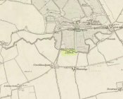
Lady Well on 1865 map

But we know that its origins as a celebrated well pre-date any christian overlay.  People were reported visiting the site from as far away as Edinburgh, such was its repute!

Much later when the Ordnance Survey lads came here, showing it on their first map of Airth, they made their own notes of the place, saying briefly,

“A small well close to the Pow Burn – it is supposed to have derived its name from the Custom of dedicating wells to the Virgin Mary – so Common prior to the Reformation. It is not a mineral well.”

Ugly plastic pipe is all that remains

But its demise was coming.  In the wake of the christian Industrialists and their myth, subsuming the necessary integral sacrality of the Earth, the waters of the well were eventually covered.  When the Royal Commission (1963) lads gave the site their attention in October 1954, they reported that “no structural remains” of any form could be seen here, and in recent years all trace of the well has vanished completely.  When we visited the site a few months ago, perhaps the very last remnant of it was a small plastic pipe sticking out of the muddy bankside, dripping dirty water into the equally dirty Pow Burn.

It would be good if local people could at least put a plaque hereby to remind people of the history and heritage that was once so integral to the way they lived their lives.

References:

  1. Bennett, Paul, Ancient and Holy Wells of Stirling, TNA 2018.
  2. Fraser, Alexander, Northern Folk-lore on Wells and Water, Advertiser Office: Invermess 1878.
  3. Frost, Thomas, “Saints and Holy Wells,” in Bygone Church Life in Scotland (W. Andrews: Hull 1899).
  4. Hone, William, The Every-day Book – volume 2, Thomas Tegg: London 1837.
  5. MacFarlane, Walter, Geographical Collections Relating to Scotland – volume 1, Edinburgh Universoty Press 1906.
  6. MacKinlay, James M., Folklore of Scottish Lochs and Springs, William Hodge: Glasgow 1893.
  7. Morris, Ruth & Frank, Scottish Healing Wells, Alethea: Sandy 1982.
  8. Murray, G.L., Records of Falkirk Parish – volume 1, Duncan & Murray, Falkirk 1887.
  9. Reid, John, The Place-Names of Falkirk and East Stirlingshire, Falkirk Local History Society 2009.
  10. Royal Commission on the Ancient & Historical Monuments Scotland, Stirling – volume 2, HMSO: Edinburgh 1963.

© Paul BennettThe Northern Antiquarian


Firbhreige, North Uist, Outer Hebrides

Standing Stones:  OS Grid Reference – NF 7700 7031

Also known as:

  1. Canmore ID 10079
  2. Toroghas

Getting Here

This is nice n’ far north indeed – north-west Uist in fact!  Hit the A865 road northwest to the village of Ceann a’ Bhaigh.  By the little church at the little crossroad, take the track on your right which leads you into the hills.  Go all the way to the end of this track and walk straight north for a couple of hundred yards, as if you’re heading up the hill, Toroghas, in front of you.

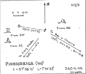
Thom’s drawing of the Stones & possible alignments


Archaeology & History

Here are two small standing stones, each not much more than three-feet tall, about 40 yards apart.  Alexander Thom (1984) looked for astronomical alignments here, but found very little, merely commenting:  “From here a number of sites are visible, but the (easternmost) stone might be said to indicate Craig Hasten or Deaskeir Islet.”  In his own analysis of the site, Clive Ruggles (UI23 – 1984) also found such astronomy lacking here.

Folklore

In Thom, Thom & Burl’s (1990) description of these two small stones, Aubrey Burl mentioned how “their name is similar to the stones on Skye called ‘Na Fir Bhreige’, or ‘the false men’. This has been variously interpreted as meaning men who were turned to stone for being unfaithful to their wives or, alternatively, to stones that from a distance resembled men.”  Which is apparently the tale here. (see Grinsell 1976)

Comparative religious studies clearly indicate that legends of petrified beings are representative of the spirits of the ancestors residing in the said stones or other artifact.  If there’s any validity to this ingredient, it would imply that some prehistoric burials can be found nearby — though my archaeo-records show nothing (but that doesn’t mean they’re not there).  If there anyone goes wandering hereabouts in the near future, see if you can find any tombs in the locale.

References:

  1. Beveridge, Erskine, North Uist: Archaeology and Topography, William Brown: Edinburgh 1911.
  2. Ruggle, C.L.N., Megalithic Astronomy, BAR: Oxford 1984.
  3. Thom, A., Thom, A.S. & Burl, A., Stone Rows and Standing Stones, vol.1, BAR: Oxford 1990.

© Paul BennettThe Northern Antiquarian


Carra Bhroin, Lochboisdale, South Uist

Standing Stone:  OS Grid Reference – NF 8117 2248

Also Known as:

  1. Canmore ID 10138
  2. Carragh broin

Archaeology & History

The nature of this site seems a little disputed.  Shown on modern OS-maps and cited as being visited and seen in April 1967, the Canmore website also describes it in the present tense — but when I.A. Crawford (1965) wrote of this site he told that, “this standing stone…has been destroyed in fencing operations” — i.e., building a fence or wall, not some doods having a fencing fight!

Equally curious would be the stature of the site; as in the Royal Commission report (1928), the stone was told to be only 2-feet tall — which would mean that if this site is included as an authentic archaeological site, then we’re gonna have to double or treble the number of standing stone sites nationally!  There are masses of ‘monoliths’ two-feet tall and above which are in the ‘natural’ category.  But this stone, for whatever reason (the folklore probably), has been granted the providence as an authentic standing stone.

Folklore

Tradition told that this old stone was “alleged to mark a battle site” in ancient days.  The variation on this theme tells that the stone marked the grave of a man who was slewn in battle here.  Seems likely that there will be prehistoric tombs nearby…

References:

  1. Crawford, I.A., ‘Carra Bhroin, S.Uist,’ in Discovery & Excavation in Scotland, 1965, SRG & CBA 1965.
  2. Royal Commission on the Ancient & Historical Monuments & Constructions of Scotland, Inventory of Monuments and Constructions in the Outer Hebrides, Skye and the Small Isles, HMSO: Edinburgh 1928.

© Paul BennettThe Northern Antiquarian


Na Clachan Bhreige, Kirkibost, Strathaird, Skye

Stone Circle:  OS Grid Reference –  NG 5432 1768

Also known as:

  1. The False Stones
  2. Na Clachan Breitheach
  3. Strathaird Circle

Getting Here

Way off from seemingly anywhere this one – on the southern foothills of the great Cuillins, by the western edge of a seemingly unnamed loch. (most unusual) Take the Elgol road (A881) south from Broadford, nearly to its end, keeping an eye out for Kirkibost a few miles from the very end of the road. Just past here, stop and walk the track west to Camasunary a half-mile along, through the small forestry-bit, then follow the line of the trees north and keep going a bit more till y’ reach the nice stream that feeds that unnamed loch. Cross the stream!

Archaeology & History

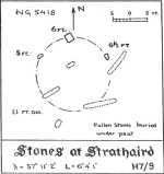
Alexander Thom's 1967 drawing

Alexander Thom’s 1967 drawing

A fascinating little site this one! Perhaps consisting of as many as eight stones at one time, only three stand visible today.  Alexander Thom (1967) reported finding other stones in this circle “being buried in the peat, but prodding revealed their position roughly” — as shown on his drawing here.  There may at one time have been as many as eight stones here, but the site itself is quite small, making a ring of stones only 21-feet across (or 8 megalithic yards as Thom had it).  The ruinous state of the site was put down to the stupidity of the Church of Scotland issuing “instructions that all stones in Skye were to be thrown down” a few centuries back.

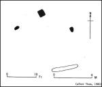
Aubrey Burl's later 'four-poster' summary

Aubrey Burl’s later ‘four-poster’ summary

Aubrey Burl reported that “there were once at least 4 stones here, the tallest being of 6ft 6ins (2m) high,” and wondered whether this was one of the many ‘four-poster’ stone circles that scatter Scotland and elsewhere.  An issue he seemed comfortable to proclaim a few years later in his survey of such sites. (Burl 1988) Of those stones still standing, the tallest is just 5 feet high; but there’s the impressive 11½-foot long monolith laying on the southeast edge of the ring!  Mr Burl also pointed out that some

“casual digging  inside the ring around 1860 uncovered a blackpolished stone about 1½ ins (4cm) long, ‘somewhat resembling a small pestle.’”

I found the proximity of the Cille Mhaire burial ground a mile west of here more than a bit intriguing (though didn’t have time to assess its geomantic relationship further).  And the reported presence of prehistoric cairns nearby imply that the Na Clachan Bhreige ‘circle’ had some relationship with death and burial.

Folklore

The folkname of ‘The False Stones’ comes from that well-known tale of the site “supposedly being the remains of three men turned into stone for deserting their wives.”  Something which Otta Swire (1964) thought was likely told by christian converts.  It would have probably replaced an earlier tale of the stones being the site where some ancestral spirits lived.  Swire also told that,

“these were once, if tradition is to be believed, Stones of Wisdom who could both foretell the future and show justice as between man and man.”

Burl (1988) also points out how,

“The name, Na Clachan Bhreige, has been variously pointed translated as ‘the judicial stones’, a place where medieval law courts were held, as in several other Scottish rings.  It has also been interpreted as ‘the stone of lies, or falsehood.’”

References:

  1. Burl, Aubrey, Four Posters: Bronze Age Stone Circles of Western Europe, BAR: Oxford 1988.
  2. Grinsell, L.V., Folklore of Prehistoric Sites in Britain, Hale: Newton Abbot 1976.
  3. Swire, Otta F., Skye: The Island and its Legends, Blackie & Sons: Glasgow 1961.
  4. Thom, Alexander, Megalithic Sites in Britain, Oxford University Press 1967.
  5. Thom, A., Thom, A.S. & Burl, Aubrey, Megalithic Rings, BAR: Oxford 1980.

© Paul BennettThe Northern Antiquarian


Beinn na Cailleach, Broadford, Skye

Sacred Mountain:  OS Grid Reference – NG 601 232

Getting Here

Seems rather daft giving directions for a mountain, but… For incomers, cross the bridge onto the island and keep on the A87 road to Broadford.  A couple of mile the other side of the village westwards, take the small left turn in the trees and go to the dead-end.  The hill reaching up above you (west) is the legendary mountain to walk up!

Folklore

Beinn na Cailleach

This giant old mountain has been associated with the primal female creation figure, the cailleach, for many a moon. And strangely – for me anyway – I’ve not ventured to sleep with this old place in my passings here as I usually do wherever the cailleach resides.

It doubtless has many more tales than the one A.A. MacGregor (1937) mentions in his superb Peat-Fire Flame.  Here he tells the story of,

“the cairn situated on the summit of Beinn na Cailleach, not far from Broadford… This cairn is believed to mark the site of burial of a Norse princess who died at Ord. On her deathbed this princess commanded her attendants to convey her, when dead to the top of Beinn na Cailleach, and to bury her there, in order that she might lie in the wake of the winds from Norway.”

MacGregor then follows the tale with a lovely note on some boring old dood he obviously had little respect for, saying:

“It is the traditions associated with this cairn that MacCulloch, the geologist, in his Description of the Western Isles of Scotland, asks to be excused from repeating, since he considers them, one and all, to be unworthy of regard. But, then, MacCulloch was a most tiresome fellow; and he seems to have imbued most of his writings with something of the same tiresomeness”!

On the lower northeastern slopes of this great mountain we find another of the old woman’s abodes, the ‘Lochain Beinn na Cailleach’, where this great hag would no doubt wash her linen, as many old myths tell she did at other pools of the same name.

A slightly different version of the folktale was told by Archibald Geikie in his Note-book of a Field Geologist from 1858:

“The top of Beinn na Cailleaich is flat and smooth, surmounted in the centre by a cairn. Tradition tells that beneath these stones there rest the bones of the nurse of a Norwegian princess. She had accompanied her mistress to “the misty hills of Skye,” and eventually died there. But the love of home continued strong with her to the end, for it was her last request that she might be buried on the top of Beinn na Cailleaich, that the clear northern breezes, coming fresh from the land of her childhood, might blow over her grave.”

An early essay in the Gentleman’s Magazine in 1841 tells the grave atop of the mountain to have been the resting place of the Norwegian King Haco’s wife or his nurse. Derek Cooper (1970) meanwhile told us that whilst the cairn was “erected as a memorial to a Skye chieftain,” the cailleach of the mountain, or “the old woman is reputedly Saucy Mary, who laid a chain between Kyle and Kyleakin to exact toll from passing ships.”

There are other mythic place-names scattered around the edges of this mountain with hints of ancient female deities, or pagan goddesses — whichever way one cares to see them.

References:

  1. Cooper, Roy, Skye, Routledge: London 1970.
  2. Geikie, Archibald, The Story of a Boulder, MacMillan: London 1858.
  3. MacGregor, Alisdair Alpin, The Peat-Fire Flame: Folk-Tales and Traditions of the Highlands and Islands, Ettrick Press: Edinburgh 1937.
  4. o’ Crualaoich, Gearoid, The Book of the Cailleach, Cork University Press 2003.
  5. Swire, Otta F., Skye: The Island and its Legends, Blackie & Sons: London 1961.

© Paul BennettThe Northern Antiquarian


Lady’s Well, Blythborough, Suffolk

Healing Well:  OS Grid Reference – TM 450 762

Also Known as:

  1. Wishing Well
  2. Queen Ann’s Well
  3. Lady’s Fountain

Getting Here

The site is found down Spring Lane at the south end of Henham Park. The current A145 meeting the A12.

Archaeology & History

A large structure is a brick and stone arch and which has two low seats inside, giving the alternative name of Tramp’s or Traveller’s Rest having also brass cups attached to the structure for anyone wishing to drink there. The age of the fabric has said to be mainly 1780, although one view was that it was erected by the first Countess of Stradbrooke in the 19th century and may be that recorded in 1833 in the poem ‘Lady’s Fountain’ poem by Agnes Strickland (the alternative name Lady coming from the Lady Strickland).  Another view is that some of the fabric is 13th century in origin.   The structure is now dry and overgrown, apparently last having water in the 1900s.

ladyswell1

Folklore

The spring is said to be near the reputed to be the place of King Onna’s death (654 AD). This was the battle of Bulcamp where Onna was chased by the Pagan Penda along Kings Lane, a lane which cuts through nearby parishes of Sotherton, Henham and Blyford to here were they stood their ground and he and his son Firminus were killed and buried. The well being erected where the king’s body fell. The legend clearly explains the site’s other alternative name of Queen Anne’s well…Anne being close enough to Onna to be semantically changed over time, and misrepresented as a Queen rather than a King!

References:

  1. R.B. Parish, Holy wells and healing springs of Suffolk (in publication)

Links:

  1. Holy & Healing Wells – A Suffolk Field Trip


Clach na h-ealea, Clachan, Lismore, Argyll

Legendary Stone:  OS Grid Reference – NM 861 435

Also Known as:

  1. Clach na h-eala
  2. Stone of the Swan
  3. Swan Stone

Archaeology & History

Although the lads at the Scottish Royal Commission (1974) initially described this site as a ‘Standing Stone’, it is in fact,

“an erratic boulder of granite roughly shaped in the form of a cross… It measures 0.8m in height, 0.6m in width at base, and 0.4m in width at the top…(and) the stone is supposed to have marked a boundary.”

The site was evidently of some mythic importance, as the great Cathedral of St. Moluag was built next to the stone — unless the giant cairn of Cnoc Aingil, 500 yards away, was to blame. A holy well of this saint’s name (an obvious heathen site beforehand) is also nearby.

Folklore

Although this stone was dedicated to swans, I’ve not found the story behind the name.  There were no buried swans here, but local tradition told that this old boulder could give sanctuary to anyone who touched it, or ran round it sunwise.  The Hebridean folklorist Otta Swire (1964) told that,

“anyone who claimed such sanctuary had his case considered by ‘the Elders.’ If they considered his plea justified, they ‘came out and walked sun-wise round the Swan Stone.’ If they did not approve of his right to sanctuary, they walked round it anti-clockwise and the man was then given over, not to his enemies, but ‘to Authority’ to be tried.”

This old tradition derives from well known pre-christian rites. Swire also reported that even in the 1960s here, “at funerals the coffin is always carried round the grave sun-wise before being laid in it.” An old cross placed in the Field of the Cross next to the stone was an attempt to tease folk away from heathen rites of the stone, but failed.

References:

  1. Royal Commission on the Ancient & Historical Monuments of Scotland, Argyll – volume 2: Lorn, RCAHMS: Edinburgh 1974.
  2. Swire, O.F., The Inner Hebrides and their Legends, Collins: London 1964.

© Paul BennettThe Northern Antiquarian

Gorrick’s Spring, Calverton, Buckinghamshire

Healing Well:  OS Grid Reference – SP 7880 3930

Getting Here

Take the Calverton Road out of Stoney Statford, then take the left hand road to Calverton and look for layby on the right near a copse.

Archaeology & History

Gorrick’s spring is an interesting site and perhaps the best of the county’s holy wells. The water flows from a rather worn lion’s head beneath a stone arch under the steps, and pours into a stone lined chamber repaired with concrete slabs. It is reached by a series of steps from the layby and beside the spring is a narrow and as Rattue (2003) states an uncomfortable seat.

Folklore

It is unclear where the name comes from but a local legend tells how a witch’s pupil gave the sight back to a Gypsy tinker. A rhyme states in Romance around Stoney Stratford quoted by Rattue (2003):

“When Gorrick’s Spring flows fast and clear,
Stoop down and drink, for health is here,
If Gorrick’s Spring shuld e’er run dry,
Beware, for pestilence is nigh.”

Interestingly it did run dry in 1996 as noted in the local Herald of 8th November 1996:

“It’s a mystery,” confessed Calverton resident Lucinda Lourie. She said she realised water levels were currently low, but older residents of the village remembered the spring running through the drought of 1976. She said one wag at Anglian Water had suggested the source of the spring may have been a burst pipe which the Anglian Water work had cured – unlikely since the spring is reputed to have been used by monks in the 13th century!”

An author named Bartley (1928) mentioned by Rattue (2003) in his Holy Wells of Buckinghamshire notes:

 “the monks of old….deemed the delicious waters of this wayside spring as sacred, possessing healing properties for all humans. Daily the holy Friar would hie to the mossy bank and reach the water with his ancient pitcher, and bear it homeward to his suffering flock”

As Rattue (2003) notes it appears unlikely that a friar would have visited the site as there  is no record of any religious institutions connected with the site.

Extracted and amended from the below post (which also discusses St Rumbold’s Well)

http://insearchofholywellsandhealingsprings.wordpress.com/2012/01/12/a-buckinghamshire-field-trip-gorricks-spring-and-st-rumbolds-well/

References:

    1. James Rattue (2003) Holy Wells of Buckinghamshire


Halo Stone (318), Ilkley Moor, West Yorkshire

Cup-and-Ring Stone:  OS Grid Reference – SE 13223 46505

Also Known as:

  1. Carving no.154 (Hedges)
  2. Carving no.318 (Boughey & Vickerman)

Getting Here

Looking straight down at it

Looking straight down at it

From Ilkley train station, head up Cow Pasture Road and get to the Cow & Calf Hotel (if needs be, ask a local).  From its car-park, cross the road and go along the straight-ish footpath onto the moor.  Less than 200 yards on, you’ll hit a main track (and a faint cup-marked stone).  OK – walk down this track (left) for 30-40 yards, then walk left again into the heather for about 10 yards.  You’re looking for a small rounded stone and you’re damn close!

Archaeology & History

...and from another angle

…and from another angle

Just over 40 yards east of the very basic Brown Law cup-marked stone, we find this slightly more exotic petroglyph, keeping low in the undergrowth.  Difficult to see unless the daylight is just right, preferably as the sun is rising or setting (as with many neolithic carvings), on this small slightly rounded stone we see a central cup-mark surrounded by a double-ring (unfinished, perhaps on its northern edge)—although an outer cup seems to touch the edge of this second ring.  As the faint images here show, there are other cups and shallow lines also etched onto the stone, but these are gradually fading as the years go by.  It was originally found close to a small cairn that has seemingly been destroyed in recent years.

CR318drThe carving can be troublesome to find when the heather and bracken gets growing, so it’s best explored in the Winter and early Spring—unless of course you want me to show you it, along with the hundreds of others on these moors!  If so, gimme a shout. 😉

References:

  1. Boughey, Keith & Vickerman, E.A., Prehistoric Rock Art of the West Riding, WYAS: Wakefield 2003.
  2. Cowling, E.T., Rombald’s Way: A Prehistory of Mid-Wharfedale, William Walker: Otley 1946.
  3. Hedges, John (ed.), The Carved Rocks on Rombalds Moor, WYMCC: Wakefield 1986.

© Paul BennettThe Northern Antiquarian