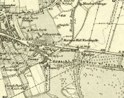
Chacefield Wood (1), Denny, Stirlingshire

Cup-and-Ring Stone:  OS Grid Reference – NS 81636 81281

Getting Here

The Chacefield carvings

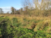
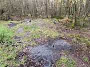
We took the A872 road on the south-side of Denny to Dennyloadhead and Longcroft, but a few hundred yards before you go under the M876, keep your eyes peeled for Drove Loan on your left.  Go down here for literally ¼-mile (0.4km) where there’s a footpath into the woods on your left.  Walk on the path into the trees and you’ll reach a track that heads to your right (east). Less than 200 yards on, you’ll see a pond on your right and above here is a small quarried rock outcrop.  This carving’s up top, on the gently sloping rock behind carvings no.2 and no.3.

Archaeology & History

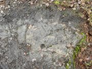
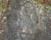
Half-covered in mud and vegetation, the first thing you’ll notice on this sloping smooth surface is what looks to be a standard cup-marking, all on its own.  But it has company—albeit quiet and faint.  A single incomplete cup-and-ring can be seen about 18 inch above (north-ish) this single cup-mark, which may itself be natural.  You can make out the cup-and-ring pretty clearly in the photos.

When we found this, we began to clear the rest of the stone but stopped pretty quickly as a scatter of broken glass was mixed into the mud and I was lucky not to cut my hand open.  Some kids have evidently been getting pissed here and have left their mess on the rock.  But there may well be more symbols beneath the mulch, so if any local folk want to clean it, please make sure to wear some good gardening gloves to protect your hands!  And if you find any other hidden elements, please let us know! 🙂

© Paul BennettThe Northern Antiquarian

Denny Bridge, Denny, Stirlingshire

Cist (destroyed):  OS Grid Reference – NS 808 830

Archaeology & History

A small and seemingly prehistoric grave, or cist, destroyed sometime around 1840, once existed on the top of a large hillock close to the River Carron where the bridge leads from Dunipace to Denny.  Thankfully, memory of its existence was preserved by Robert Watson (1845) in his short description of Dunipace parish.  He first began by talking of some large natural mounds on the eastern side of the township which, folklore told, gave rise to the place-name Dunipace; but from those mounds,

“About two miles to the westward of these hills, there was a very beautiful one about forty feet in height, and covering nearly three roods of ground, said also to be artificial.  This hill was mutilated, from time to time, for the purpose of repairing roads and other purposes.  It was entirely removed about six years ago, to form an embankment on the turnpike road near Denny bridge. The strata of which this hill was composed, were carefully observed during its removal. These were so regular, and as if rising out of, and gradually returning again to similar strata in the circumjacent level ground, as to afford conclusive evidence that the hill was not the work of man.  On the top of this hill, and about three feet below the surface, was found a coffin or tomb, composed of five large un wrought stones, in which were the bones of a human body, scull and teeth not much decayed.  Along with these, was a vase of coarse unglazed earthenware, containing a small quantity of material resembling the lining of a wasp’s nest, probably decayed paper or parchment, which in the lapse of ages had assumed that appearance.  No conjecture could be formed about the individual here interred, tradition being entirely silent on the subject ; but this circumstance corroborates the opinion of some writers, that the hills of Dunipace might have been used as burying-places for ancient chiefs.”

The site was included in the Royal Commission’s (1963:1) Inventory, but they found no additional data about it.

References:

  1. Royal Commission on the Ancient & Historical Monuments Scotland, Stirling – volume 1, HMSO: Edinburgh 1963.
  2. Royal Commission on the Ancient & Historical Monuments of Scotland, Archaeological Sites and Monuments of Stirling District, Central Region, Society of Antiquaries of Scotland 1979.
  3. Watson, Robert, “Parish of Dunipace,” in New Statistical Account of Scotland – volume 8, William Blackwood: Edinburgh 1845.

© Paul BennettThe Northern Antiquarian 

Tammy Mill’s Well, Laurieston, Falkirk, Stirlingshire

Healing Well (lost):  OS Grid Reference – NS 910 790

Also Known as:

  1. Tammy Milns Well

Archaeology & History

This all-but-forgotten site situated somewhere on the north side of Lauriston was mentioned in Falkirk’s Notes & Queries (1906) journal, but its whereabouts is somewhat of a mystery (to me at least!).   In a series of question and answers about the site, the editor of the journal, James Love, told us:

“Mr Charles Brown, factor to the Marquis of Zetland, kindly informs us that on a late occasion there passed through his hands a copy of a feu contract by the Right Honorable Francis Lord Napier in favour of Alexander Cowie, brewer, at New Merchiston (now Laurieston), of a piece of ground lying to the north of Mary Street.  This is dated 7 August, 1762 and contains the following clause:  ‘Providing also that the said Alexr Cowie and his foresaid have the Liberty of the water of Tammy Milns Well in common with the said Lord Napier’s other vassals ay New Merchiston.'”

The well was mentioned again in 1781 with similar historical information.  As to the name of the well, Mr Love wrote,

“it would appear, from the circumstance, that an old infirm man belonging to the village, called Thomas Mills or Milns, used to sit with his wooden cup at the spring which flowed from the face of the hill, over which the present structure now stands, and served out to the weary passers-by the cooling and refreshing draught for any small pittance they in their generosity might think proper to give him.  After the lands of Lauriston passed into the hands of Sir Laurence Dundas, he took the advantage of such a copious supply of what then was pure water, and built the present reservoir over the spring, and had it conveyed to Kerse House by means of leaden pipes.”

But he fails to tell us what “the present structure” was that covered the well, nor the whereabouts of the “reservoir over the spring”; and as there’s no such feature on any of the Ordnance Survey maps at the time he wrote his article, nor beforehand, I remain puzzled as to its exact position.  This situation isn’t helped by the earlier description, which said it was found on “a piece of ground lying to the north of Mary Street”.  There are two wells literlly on the other side of Mary Street, but Kerse House meanwhile—whose water supply came from the well—is about 1½ miles to the north!  All in all there are more questions than answers here.  Added to this, in John Reid’s (2009) magnum opus on local place-names, the site is mentioned, albeit in passing, where he gives us the vague grid-reference of just NS 91 79, but this may just be educated guesswork on his part.  It would be good to know exactly where it was…

References:

  1. Love, James (ed.), “Tammy Mills (or Milns) Well, Laurieston”, in Local Antiquarian Notes & Queries, Falkirk – volume 1, 1906.
  2. Reid, John, The Place-Names of Falkirk and East Stirlingshire, Falkirk Local History Society 2009.

© Paul BennettThe Northern Antiquarian


Lady Well, Airth, Stirlingshire

Holy Well (destroyed):  OS Grid Reference – NS 89801 86524

Also Known as:

  1. Canmore ID 46862
  2. Lady’s Well
  3. Spaw Well

Archaeology & History

Site of the Lady Well, Airth

Once to be seen flowing on the south-side of the Pow Burn below Airth Castle, all traces of this once sacred site has fallen prey to the usual advance of the so-called ‘civilized’.  In literary terms, the site was first described in church records from 1657—as Ladieswell—and the accounts we have of the place from then are most revealing in describing the traditional use of the place by local people.  It was a sacred site, obviously, chastised by the madness of the christian regime of the period, in their attempt to destroy indigenous customs and societal norms.  William Hone (1837) gave an extended account of what some people were up to here in his Everyday Book:

“In 1657, a mob of parishioners were summoned to the session, for believing in the powers of the well of Airth, a village about six miles north of Falkirk, on the banks of the Forth, and the whole were sentenced to be publicly rebuked for the sin. –

“”Feb. 3, 1757, Session convenit. Compeared Bessie Thomson, who declairit scho went to the well at Airth, and that schoe left money thairat, and after the can was fillat with water, they keepit it from touching the ground till they cam horm.”

“”Ffebruary 24. — Compeired Robert Fuird who declared he went to the well of Airth, and spoke nothing als he went, and that Margrat Walker went with him, and schoe said ye beleif about the well, and left money and ane napkin at the well, and all was done at her injunction.”

“”Compeared Bessie Thomson declarit schoe fetch it horn water from the said well and luit it not touch the ground in homcoming, spoke not as sha went, said the beleif at it, left money and ane nap-kin thair; and all was done at Margrat Walker’s command.”

“”Compeired Margrat Walker who denyit yat scho was at yat well befoir and yat scho gave any directions ”

“”March 10. Compeared Margrat Forsyth being demand it if scho went to the well of Airth, to fetch water thairfrom, spok not by ye waye, luit it not touch ye ground in homcoming? if scho said ye belief? left money and ane napkin at it? Answered affirmatively in every poynt, and yat Nans Brugh directit yem, and yat they had bread at ye well, with them, and yat Nans Burg said shoe wald not be affrayit to goe to yat well at midnight hir alon.”

“”Compeired Nans Burg, denyit yat ever scho had bein at yat well befoir.”

“”Compeired Robert Squir confest he went to yat well at Airth, fetchit hom water untouching ye ground, left money and said ye beleif at it.”

“”March 17. Compeired Robert Cochran, declairit, he went to the well at Airth and ane other well, bot did neither say ye beleif, nor leave money.”

“”Compeired Grissal Hutchin, declairit scho commandit the lasses yat went to yat well, say ye beleif, but dischargit hir dochter.”

“”March 21. Compeired Robert Ffuird who declairit yat Margrat Walker went to ye well of Airth to fetch water to Robert Cowie, and when schoe com thair, scho laid down money in Gods name, and ane napkin in Robert Cowie’s name.”

“”Compeired Jonet Robison who declairit yat when scho was seik, Jean Mathieson com to hir and told hir, that the water of the well of Airth was guid for seik people, and yat the said Jean hir guid sister desyrit hir fetch sum of it to hir guid man as he was seik, bot sho durst never tell him.”

“”These people were all 44 publicly admonishit for superstitious carriage.””

The practices continued.  In 1723, a Mr Johnstoun of Kirkland, writing about the parish of Airth, also told of the reputation of the well, saying,

“Upon the south side of the Pow of Airth, upon its very edge, is a spaw well famous in old times for severall cures, and at this day severalls gets good by it, either by drinking or bathing. Its commonly called by the name of Ladies well. Its about two pair of butts below Abbytown bridge.”

The fact that he told us it was “good for bathing” suggests a pool was adjacent, or at least the tiny tributary between it and the Pow Burn gave room for bathing and had a curative reputation. (there are many pools in the Scottish mountains with this repute – some are still used to this day!)

It was then described by Robert Ure in the first Statistical Account of 1792, where he told how the people were still using the waters, despite the crazy early attempts to stop them.  “There is a Well, near Abbeytown Bridge,” he told,

“called Lady-Well, which is thought to be medicinal.  Numbers have used it, and still use it as such.  It is supposed to have obtained that name, from the holy water, in the time of Popery, being taken from it, to supply the abbacy, or Catholic Church, then at Airth.”
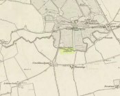
Lady Well on 1865 map

But we know that its origins as a celebrated well pre-date any christian overlay.  People were reported visiting the site from as far away as Edinburgh, such was its repute!

Much later when the Ordnance Survey lads came here, showing it on their first map of Airth, they made their own notes of the place, saying briefly,

“A small well close to the Pow Burn – it is supposed to have derived its name from the Custom of dedicating wells to the Virgin Mary – so Common prior to the Reformation. It is not a mineral well.”

Ugly plastic pipe is all that remains

But its demise was coming.  In the wake of the christian Industrialists and their myth, subsuming the necessary integral sacrality of the Earth, the waters of the well were eventually covered.  When the Royal Commission (1963) lads gave the site their attention in October 1954, they reported that “no structural remains” of any form could be seen here, and in recent years all trace of the well has vanished completely.  When we visited the site a few months ago, perhaps the very last remnant of it was a small plastic pipe sticking out of the muddy bankside, dripping dirty water into the equally dirty Pow Burn.

It would be good if local people could at least put a plaque hereby to remind people of the history and heritage that was once so integral to the way they lived their lives.

References:

  1. Bennett, Paul, Ancient and Holy Wells of Stirling, TNA 2018.
  2. Fraser, Alexander, Northern Folk-lore on Wells and Water, Advertiser Office: Invermess 1878.
  3. Frost, Thomas, “Saints and Holy Wells,” in Bygone Church Life in Scotland (W. Andrews: Hull 1899).
  4. Hone, William, The Every-day Book – volume 2, Thomas Tegg: London 1837.
  5. MacFarlane, Walter, Geographical Collections Relating to Scotland – volume 1, Edinburgh Universoty Press 1906.
  6. MacKinlay, James M., Folklore of Scottish Lochs and Springs, William Hodge: Glasgow 1893.
  7. Morris, Ruth & Frank, Scottish Healing Wells, Alethea: Sandy 1982.
  8. Murray, G.L., Records of Falkirk Parish – volume 1, Duncan & Murray, Falkirk 1887.
  9. Reid, John, The Place-Names of Falkirk and East Stirlingshire, Falkirk Local History Society 2009.
  10. Royal Commission on the Ancient & Historical Monuments Scotland, Stirling – volume 2, HMSO: Edinburgh 1963.

© Paul BennettThe Northern Antiquarian


Marion’s Well, Falkirk, Stirlingshire

Healing Well (destroyed):  OS Grid Reference – NS 8926 7977

Archaeology & History

Marion's Well on 1864 map

Marion’s Well on 1864 map

Recorded in 1860 by the Ordnance Survey and highlighted several years later, this Marionesque potential of a holy well is not thought to derive its name from the usual Catholic pantheon—but it’s close!  It was obviously an important water source for the people of Falkirk in early times and its clear waters were used to supply an early washing house close by (as shown on the map).  Now completely built over where the B8080 meets the roundabout east of the town centre, the best literary account we have was penned by the regional historian Robert Gillespie (1879) who, in his survey of the area, told us:

“Of Marion’s Well there is scant record.  According to tradition it got its name from Marion Livingston—a nun of the house of Callendar who, in the performance of the sacerdotal vow which kept her from the world, visited the well at intervals and used its soft waters as a pediluvium.   The original well which was built round with stone, stood at the bottom of the Cladden’s Brae, on the bank of the East Burn.  It was further protected by a circle of upright slabs—the great resting place of the water maids and the scene of many a happy ‘touzle’ as the stoups or pitchers were sent rolling and rattling down into the brawling brook.”

Marion's Well, c.1900

Marion’s Well, c.1900

The element of locals “touzling” here simply means that it was a meeting place for young lovers. (Grant 1973; Wright 1905)  Although quite what Gillespie meant when he said it was surrounded “by a circle of upright slabs” is anyone’s guess!  Was this architectural element constructed in the post-medieval period, or was it much much older…?

In the old photo of the well here, Scott & Astbury (1990) said how it,

“shows the trough of the well after it had been moved to the south side of Callender Road and shows a horse pulling a Barr’s cart at the trough.  The view looks down what is now Corporation Street to the bridge over the East Burn.”

References:

  1. Gillespie, Robert, Round about Falkirk, Dunn & Wright: Glasgow 1879.
  2. Grant, William & Murison, David (eds.), The Scottish National Dictionary – volume 9, SNDA: Edinburgh 1973.
  3. Morris, Ruth & Frank, Scottish Healing Wells, Alethea: Sandy 1982.
  4. Reid, John, The Place-Names of Falkirk and East Stirlingshire, Falkirk Local History Society 2009.
  5. Scott, Marion & Astbury, Tom, Falkirk’s Yesterdays, FDD: Falkirk 1986.
  6. Wright, Thomas (ed.), English Dialect Dictionary – volume 6, Henry Frowde: Oxford 1905.

© Paul BennettThe Northern Antiquarian


Wallace’s Oak, Larbert, Falkirk, Stirlingshire

Legendary Tree:  OS Grid Reference – NS 847 836?

Also Known as:

  1. Wallace’s Tree

Archaeology & History

The archaeology and traditions ascribed to this ancient tree (exact position unknown) is based on words that were first penned two hundred years ago.  It was thankfully recorded with a reasonable description when William Nimmo wrote about the great Sir William Wallace in the second edition of his Stirlingshire (1817) work.  Known about in oral tradition by local people, Nimmo told how:

“Torwood was a place where he and his party, when engaged in any expedition in this part of the country, often held their rendezvous, and to which they retreated in the hour of danger.  Here is still to be seen an aged oak, well known by the name of Wallace’s Tree; which seems to have been, even then, rotten and hollow within, and is said to have often afforded a lodging to him and a few of his trusty friends. It is supposed to have been one of the largest trees that ever grew in Scotland.  It is now almost quite decayed; but, from its ruins, appears to have been of an uncommon size. The remaining stump is no less than eleven or twelve feet in diameter. It stands upon the summit of a small eminence, which is surrounded on all sides by a swamp.  A rugged causeway runs from the south through the swamp, and leads up to the tree.  Some other vestiges of the stonework are discernible, surrounding the tree in a circular form, and leading to the conjecture that this oak is of a very high antiquity; and that, having been much frequented by Druidical priests, amongst whom the oak was sacred, the causeway had been laid for their approach to it, and the performance, underneath its branches, of religious rites.”

Nimmo may have a point here.  Not necessarily of druids (although druidic traditions and reality is known from many old tracts to have continued in many of the hidden places in Scotland), but certainly in relation to the paved track leading to a what may have been a recognised moot-hill, on top of which this great oak once stood.  Great trees and ancient meeting places were held in high esteem, not only in the legends of druidism and more established animistic pantheons, but in the recognised pragmatism of local tribal gatherings, in Scotland, Wales, England and in traditional cultures all over the world. (Gomme 1880) The traces of stonework leading to the hill strongly implies an archaeological site in the paving alone; but moreso, as an important site in the traditions of the Scottish people.  The fact that these stone ruins were still visible when Nimmo visited the site in the latter-half of the 18th century in the context he describes, implies it may have been the remains of a possible crannog; or a moot hill; or even, with its great oak surmounting, a sacred grove!  In my mind, it was probably being used as a gathering place long before William Wallace and his men gathered here…

In 1880, a 3rd edition of Nimmo’s Stirlingshire was published and edited by R. Gillespie.  Herein were additional notes about Wallace’s Oak that had been uncovered by Mr Gillespie.  Although he’d visited the place,

“Not the smallest vestige…of the Wallace oak remains. Even the ” oldest inhabitant” can say nothing of it save what he has gathered from tradition.  Sir Walter Scott, in his Tales of a Grandfather, speaks of having seen some of its roots eighty years ago; and recently we were shown a treasured morsel of the tree in the Chambers’ Institute at Peebles. Wallace, undoubtedly, often chose the solitude of the Torwood as a place of rest for his army, raised and roused to oppose the tyranny of Edward.  Here he concealed his numbers and his designs, sallying out suddenly on the enemy’s garrisons, and retreating as suddenly when afraid of being overpowered. While his army lay in these woods, “the oak” was his head-quarters. Within it, the illustrious hero generally slept, the hollow trunk being huge enough to afford shelter both to himself and one or more of his associates.”

When John Gibson (1908) came to write about it, he told that “Wallace’s Oak, which stood on another part of Woodside (low Torwood), has…vanished.” No roots, no lingering trunk—nothing.  But although the tree has long since gone, William M. Stirling pointed out in 1817 that,

“A young tree is pointed out in the neighbourhood, as having sprung from an acorn of Wallace’s Oak.”

If and when we can locate the old toll-house of Broomage at Larbert, we get much closer to identifying the exact location of this long lost oak.  Then, perhaps, a commemorative plaque should surely be placed there to remind people of their great history, and included on tours of sites relating to Sir William Wallace.

References:

  1. Gibson, John C., Lands and Lairds of Larbert and Dunipace Parishes, Hugh Hopkins: Glasgow 1908.
  2. Gomme, George L., Primitive Folk-Moots, Sampson Low: London 1880.
  3. Nimmo, William, The History of Stirlingshire (2nd edition), John Frazer: Stirling 1817.

© Paul Bennett, The Northern Antiquarian