Carmyllie Hill, Greystone, Angus

Cairn:  OS Grid Reference – NO 545 434

Also Known as:

  1. Fairyfold Hillock
  2. Fairy Folk Hillock

Folklore

An intriguing site this, as it doesn’t appear to be in the Canmore archaeological register – unless it’s the Canmore site 34750.  Yet Alexander MacGregor (1937) mentions the place in his folklore study as being a site where the little people lived.  Shown on the first OS-map of the region as ‘Fairyfold Hillock’, Mr MacGregor (1937) said of it:

“Near the summit of Carmylie Hill is a large barrow or tumulus, which was believed at one time by the natives to be a favourite haunt of the fairies, where, with much splendour, they held their nightly revels. It still bears the name of ‘Fairy-Folk Hillock.'”

However it seems that quarrying operations may have destroyed the site.  The tomb here was probably the same one described by Mr Andrew Jervise in the Journal of the Kilkenny and South East of Ireland Archaeological Society (1864-66), where he wrote:

“Many years ago I took note of another example of these ‘footmarks,’ which was found in the parish of Carmyllie…  This was discovered in the course of making agricultural improvements some thirty-five years ago, on which occasion stone coffins or cists were got, and in one of these was a bronze (?) ring, of about three inches in diameter, now said to be lost.  Apart from the cists there was a rude boulder of about two tons weight; and upon the lower side of it, as my informant told me, was scooped the representation of a human foot. This too was associated with the elves; for the hillock upon which these discoveries were made was called the ‘fairies’ knowe;’ and tradition says that, but for a spirit that warned the workmen to suspend operations when they began to prepare for the foundations of the parish church, the church would have been built upon that spot!”

References:

  1. MacGregor, Alexander, Highland Superstitions, Eneas MacKay: Stirling 1937.

© Paul Bennett, The Northern Antiquarian

Culliford Tree Barrow, Upwey, Dorset

Tumulus:  OS Grid Reference – SY 6691 8548

Also Known as:

  1. Music Barrow
  2. Warne’s Barrow 22
  3. Whitcombe 1 (Grinsell)

Archaeology & History

Crowned by a clump of trees (planted in 1740), this hilltop site is one of the more impressive of a number of tombs hereby, with its nearest other neighbour being 70 yards southeast of here.  One of Dorset’s early tribal meeting places (Anderson 1934), the tomb was illustrated on Isaac Taylor’s 1765 map of the region and was dug into in 1858 “on the orders of a local magnate” (Marsden 1999), damaging some substantial portion of the tomb.  Of this, craniologist and antiquarian John Thurnam was most displeased; for in his description of the opening of Culliford Tree he wrote:

“A wide trench had been dug through it one side, from the summit and the rubble which had been thrown out had not been replaced… Another subject of regret was the fact that though, as we were told by the neighbouring rustics, human remains, with pottery and certain other relics, were found in the barrow, no authentic account of the exploration had, so far as we could learn, been put to print.”

Leslie Grinsell (1959) found the same trouble in his assessment of this site; and the Royal Commission (1970) lads could only describe the site thus:

“Large trench on south and top almost certainly dug in 1858 when four secondary extended inhumations, one with necklace of amber and two gold-plated beads, and cremation with incense cup in collared urn, were found.”

However, it seems that the necklace and gold-plated beads have been “lost” — i.e., someone has them in their own private collection somewhere!

Folklore

This is one of very few tombs in this part of the country where we find the tradition of fairy music.  Grinsell (1959) told that:

“The Culliford Tree barrow, formerly the meeting place of the Hundred of Culllingford Tree, is also known as the Music Barrow from the belief that music could be heard beneath the mound by those who listened at the apex at midday.”

References:

  1. Anderson, O.S., The English Hundred-Names, Lunds Universitets Arsskrift 1934.
  2. Grinsell, Leslie V., Dorset Barrows, Dorset Natural History & Archaeological Society: Dorchester 1959.
  3. Marsden, Barry M., The Early Barrow Diggers, Tempus: Stroud 1999.
  4. Royal Commission on Historical Monuments, An Inventory of Historical Monuments in the County of Dorset – Volume 2: South-East, Part 3, HMSO: London 1970.
  5. Warne, Charles, Celtic Tumuli of Dorset: An Account of Personal and other Researches in the Sepulchral Mounds of the Durotriges, Smith: London 1866.

© Paul Bennett, The Northern Antiquarian


Clach na Sithean, Strathtay, Perthshire

Cup-Marked Stone:  OS Grid Reference – NN 895 531

Also Known as:

  1. Balendune
  2. Ballinduin

Folklore

This large cup-marked stone was known by local people as the Clach na Sithean, or the stone of the fairies.  Its smooth surface and well-cut grooves was said to be due to the fairies sharpening their knives upon it, and the straight cuts or grooves were tests of the keenness of their blades.

In addition to the fairies having hold over this stone, a brownie creature also roamed between here and the burn of Allt Mor.  Although a dutiful creature, he commonly used to scare the women when they returned from the ceilidhs by chasing them and screaming a curious noise at them. But as well as this, he would also enter the local houses and farms after nightfall and, when the local folk were asleep, would clean the supper dishes and put them in their rightful places. But if there was no work to be done once he had entered their homes, he would take the dishes out and place them on the floors where they would be found in the morning by perplexed householders.  Then they’d know that the brownie had visited. Sometimes he was a great help to the housewives, other times a nuisance.  He became known to local people as Puddlefoot, or Cas an Lubain, but so offended was he by the name when he heard it, that he let out an almighty scream and vanished, never to be seen again.

References:

  1. Kennedy, James, Folklore and Reminiscences of Strathtay and Grandtully, Munro Press: Perth 1927.

© Paul Bennett, The Northern Antiquarian

Clach na Buidseach, Strathtay, Perthshire

Cup-Marked Stone:  OS Grid Reference – NN 916 541

Also Known as:

  1. The Witchcraft Stone
  2. Witches Stone

Folklore

In Mr Kennedy’s book (1927) on the folklore of Strathtay, he informed that this Witches Stone was examined and taken to Edinburgh sometime in the 19th Century, but returned to its home by a local man called Mr McNaughton who lived at Bail-an-eas.  The stone was restored close to the walls in which it was first found.  He also told us the following:

“In bygone days the witches of Strathtay amd Grandtully had their great meeting place at Tulliepourie. There the Witches’ Stone…with its round bowl-shaped holes, is still in evidence. Satan attended and assumed the shape of a he-goat; but going to the meeting he is said to have rolled along in the shape of a large cart-wheel – gyrating and describing the figure eight. This must have been an exceedingly interesting site! The orgies that ensued at these meetings were disgustingly wicked!”

The fairy folk, whose main home was the hill of Craig Scriadlain further uphill from here, would also have their revelries here.  Many of the other sites near here were also used by the same little people of Scriadlain.

References:

  1. Kennedy, James, Folklore and Reminiscences of Strathtay and Grandtully, Munro Press: Perth 1927.

© Paul Bennett, The Northern Antiquarian

Fairy Well, Barrow Gurney, Somerset

Sacred Well:  OS Grid Reference – ST 53243 68625

Getting Here

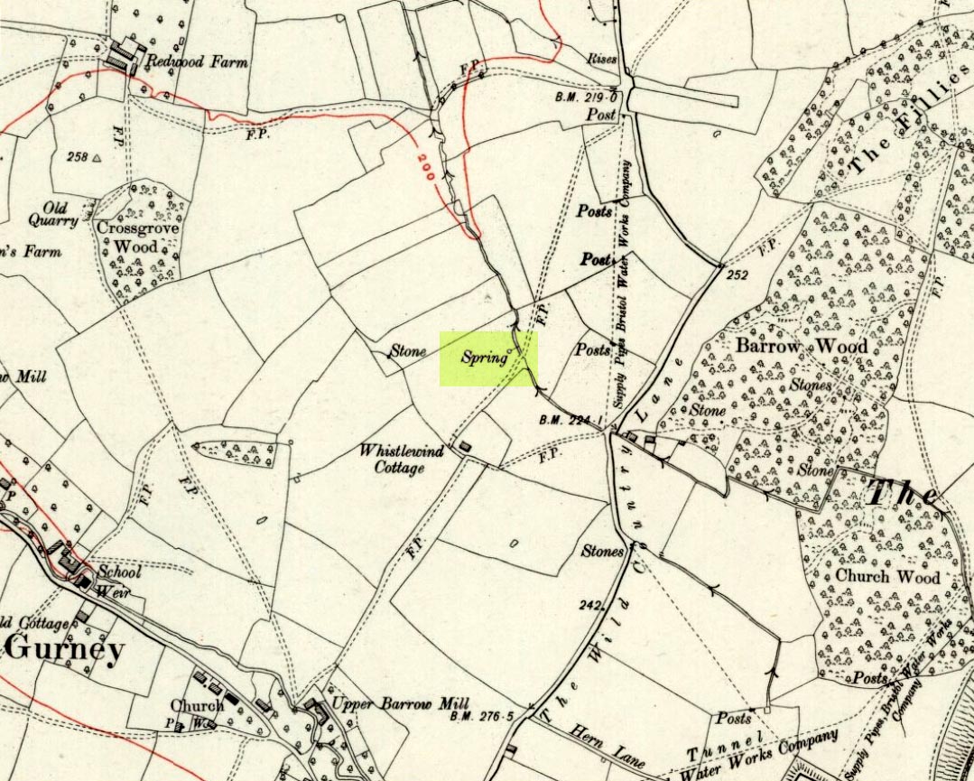
Fairy Spring on 1921 OS-map

Go up the nicely-named Wildcountry Lane at the staggered crossroads on the edge of Barrow Gurney for about a half-mile, watching out for the dip in the road where it crosses the stream.  Walk up the stream here for a coupla hundred yards, keeping your eyes peeled for the small spring on your left just past where a footpath crosses the stream.

Archaeology & History

Little of historical nature is known of this site, found in the dip near the stream, though it was much frequented in bygone centuries as a curative place for sore eyes.

Folklore

Although named after the little people, Phil Quinn (1999) wrote that,

“even the oldest villager cannot remember how the fairies became connected with this well.  All that is told is that the people would go to the well to bathe their eyes, for the water was believed to be good in the treatment of all eye complaints. A local woman remembers that her father, who worked the land in this neighbourhood, would always drink from the well using a cup which was never taken away or used for any other purpose.”

It is likely that the fairy association here derived from the proximity of a nearby prehistoric tomb, cairn or similar archaeological remain.  The aptly-named Barrow Wood immediately east and other ‘barrow’ place-names nearby would add weight to this notion. (faerie-lore has widespread associations with prehistoric tombs and similar relics)

References:

  1. Quinn, Phil, The Holy Wells of Bath and Bristol Region, Logaston: Almeley 1999.

© Paul Bennett, The Northern Antiquarian

Pots and Pans Stone, Greenfield, Lancashire

Legendary Rocks:  OS Grid Reference – SE 01008 05072

Also Known as:

  1. Druid Stone

Getting Here

Pots & Pans on 1854 OS-map

Dead easy! From the townships of Grasscroft, Uppermill, or Greenfield, take the legendary moorland road up to Saddleworth tops (A635), keeping your eye on the modern obelisk on the hilltop to your left and you’ll see a large rock outcrop almost next to it.  That’s where you’re heading.  Once you reach near the moorland level, walk in whatever way you see fit towards the obelisk and large stones.  Enjoy…!  I s’ppose though, it’d be better for you if you started from the valley bottom at Uppermill and walked up the hill.

Folklore

Seemingly a ritual place of the sun, this fine site was known by the local folk-name of the Druid Stones, according to Jessica Lofthouse. (1976)  But more importantly in legend, this great rocky outcrop was the abode of an old giant called Alphin, who had a rival called Alder who also wandered the moors here.  Both these giants vied for the hand of a lady called Rimmon, who preferred Alphin to Alder. In good old fashioned ways they contested for her hand, throwing giant rocks across the moors at each other, but “Alphin was hit and killed, with Rimmon looking on.”  His grave lies on these moors somewhere, seemingly unfound.   …And intriguingly it seems that we’ve actually located a prehistoric tomb which may account for the legend of Alphin’s death! (Watch this space!)

A slight variation on the tale describes the Lady Rimmon to be of fairy stock, named ‘Raura Peena’ (a phonetic spelling of a local dialect name), who in one account from the Notes & Queries journal, 1850, tried luring a local man into her magickal recess of the Fairy Holes, on the slopes beneath the Pots and Pans Stone.

Local tradition also tells that the naturally-worn ‘bowls’ atop of the rocks held magical properties — water being collected from them was said to be good to cure eye problems.  This is a curative theme we find at some bullauns, cup-marked stones and old cross-bases and would strongly indicates that pre-christian practices did once take place here.

References:

  1. Lofthouse, Jessica, North Country Folklore, Robert Hale: London 1976.

© Paul Bennett, The Northern Antiquarian


Fairy Loch, Arrochar, Argyll

Sacred Loch:  OS Grid Reference – NS 3384 9937

Also Known as:

  1. Lochan Uiane

Getting Here

Fairy Loch on 1865 map

To get here, go down the A82 about four-and-a-half miles south of Tarbet (along the Loch Lomond road). Near a burn coming down the hill is an old house, long in ruin, and near the side of this is an old path – more for deer than city-folk. Go up through the wooded hillside for about a half-mile (amble the trek and make it a nice hour’s walk to get into the place). I’d take the stream itself, as you get more into the nature of the place once you get up the slope: there’s more to see, feel and a healthy water supply en route.

Folklore

This is more of a ‘holy loch’ than a holy well — for obvious reasons.  Although it’s not much bigger than a large pond, it is little-known, but has long had the tradition of being an abode of the sith, or faerie-folk. There is, of course, a tendency to find prehistoric remains where the sith have their repute, but there seems little on official records nearby.

Tradition tells that the loch was actually formed in ancient times by locals damming the burn for water supply. Another tells the same in order that a mill could be fed with constant water – though no mill can be found. If this latter tradition is true however, the fairy creature here could have been a brownie – though they are generally more a lowland elemental. One of the reasons the place has been named after the little people is that when certain light falls on it, at the right time of day and year, green triangular shapes emerge from the water formed by deposits hidden beneath the surface (hence the original Gaelic name, Lochan Uaine, or the Green Loch).

Local historian Norman Douglas echoed the folktale described many years earlier by the great John Gregorson Campbell (1900), telling that,

“another story is that the local people would deposit their sheeps’ fleeces in the Fairy Loch overnight, wish for them to be dyed a certain colour, and overnight the fairies would carry out their wish.”

References:

  1. Campbell, John G., Superstitions of the Highlands and Islands of Scotland, James MacLehose: Glasgow 1900.
  2. Douglas, Norman, Arrochar, Reiver Press: Galashiels n.d. (c.1971)

© Paul Bennett, The Northern Antiquarian


Ox-Foot Stone, South Lopham, Norfolk

Standing Stone (destroyed):  OS Grid Reference – TM 052 809

Folklore

This slab of sandstone apparently used to stand upright in one of the fields of Oxfootstone Farm and on its surface is supposed to be the burnt impression of a cow’s hoof-print. Legend tells that there was a fairy cow which would come into the area when times of hardship occurred. During such periods she would freely give her milk to the people, but when the drought was over she stamped down on the stone upon which she stood, burning the imprint of her hoof onto it and magically vanished back from whence she came. A variation of the tale tells of a normal cow whose milk normally supplied the local villagers. But one night a drunken man (in another tale it is a witch) milked the cow dry through a sieve, until only blood came from her udders. At this point, the cow cried out in pain and kicked the stone so hard that she left the mark of her hoof-print on it.

Another tale tells that an ox got a large thorn stuck in its foot and rampaged through the local village, eventually stamping its hoof onto the stone so hard that it left the imprint of its foot here.

Now this might sound presumptious of me — but this tale has all the hallmarks of it being an old folk-remnant telling the origin of some cup-and-ring marked stone.  We find a number of cup-and-rings with creation tales similar to this.  Are there any local archaeologists or enthusiasts in Norfolk who might be able to locate any remains of this possible carved stone?

References:

  1. Burgess, Michael W., The Standing Stones of Norfolk and Suffolk, ESNA 1: Lowestoft 1978.
  2. Dutt, W.A., The Ancient Mark-Stones of East Anglia, Flood & Sons: Lowestoft, 1926.

© Paul Bennett, The Northern Antiquarian


Old Bess Stone, Oakworth Moor, West Yorkshire

Standing Stone:  OS Grid Reference – SD 978 389

Getting Here

A bittova wander with not much to see, if truth be had.  Best way here’s from the top Oakworth Road heading to the Lancashire border, right on the moor-edge.  Go along the Hare Hill Edge road for a coupla miles till you hit the Pennine Way.  Walk along it up onto the moor, following the dead straight walling for several hundred yards.  Where the walling stops, all of a sudden, stop! (there’s a wooden post here)  Now walk left (west) across the heath for less than 100 yards.  You’ll find it…

Archaeology & History

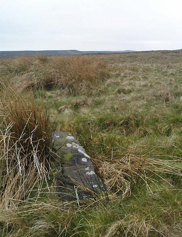
Old Bess Stone, with Crow Hill on the distant skyline

I’ve found nothing of this site in archaeology records – but that’s likely down to me not looking hard enough!  I’m not even sure that it’s prehistoric – but as there’s nowt written about it, and there are other sites which relate to this old stone, it’s certainly worthy of mention.

The stone lays in the grasses, some four-feet long, with a more recent 18th-19th century boundary stone laid a few feet away.  It seems most likely that Old Bess had stood here much longer though.  Old Bess seems to be the first in a row of at least 6 seemingly unrecognized boundary stones running northwest in a straight line up to the Wolf Stones, about half-a-mile from here.  Neither the early, nor modern OS-maps show any of these stones, several of which are accompanied by earlier, more worn stones – two of which have the letters ‘C.C.’ or ‘G.C.’ carved on them.

Old Bess 'hut circle'
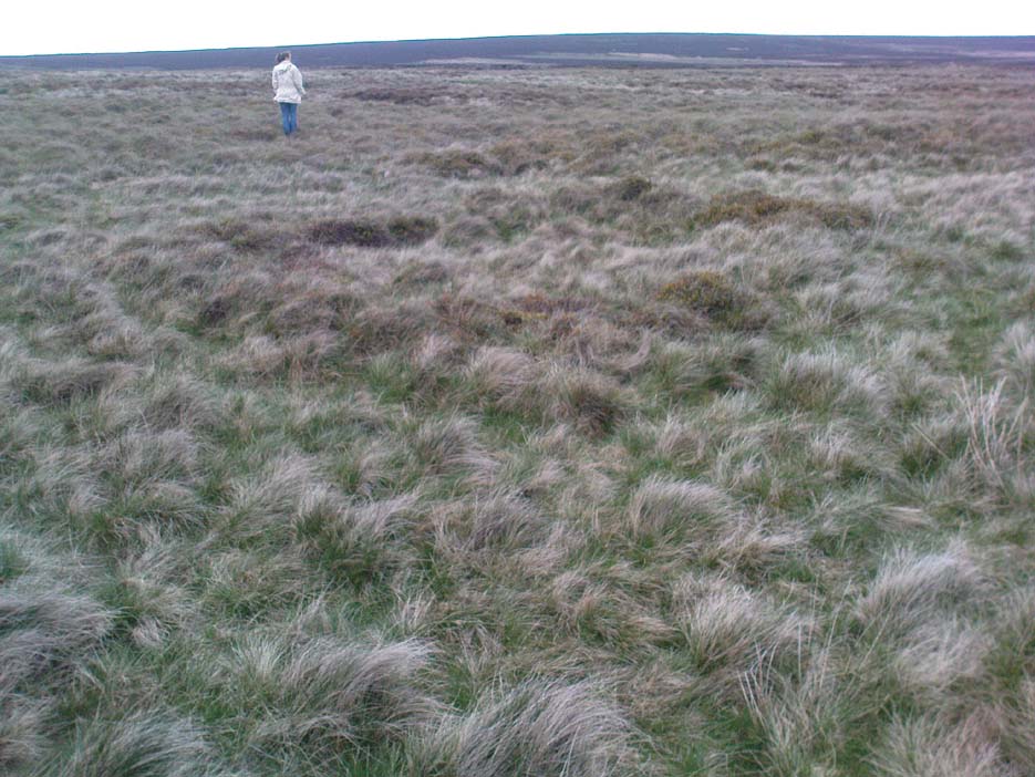
Old Bess ‘hut circle’ (it’s there – honest!)

About 10 yards north of Old Bess are the remains of a very noticeable oval-shaped ‘hut circle’ – or something closely resembling such remains.  About five yards across at the most, with stone walling making up the edge of the ring beneath the moorland grasses, an excavation here wouldn’t go amiss!  Although it’s hard to see in this photo (it’s the roughly circular rise in the middle), when you’re on the moor it’s obvious.   It looks and feels as if the remains were something from medieval times, or perhaps even later – but it’d be good to know for sure!  The remains of an old delph 100 yards south may account for more of Old Bess and its accompanying hut circle than owt prehistoric.

From Old Bess, walk in a straight line towards the large rock outcrop of the Wolf Stones, northwest of here.  After a short distance you’ll come across another large stone, cut and shaped in bygone centuries (not prehistoric though) laying in the boggy tussock grass and looking similar to Old Bess.  Another 100 yards on from here, along the same straight line towards the Wolf Stones, you’ll find another cut stone of similar dimensions; and from here you’ll see another stone about the same distance again ahead of you.  These would appear to be the lost medieval boundary stones which led to a boundary dispute between the counties of Yorkshire and Lancashire a few centuries ago.  For those medieval historians amongst you, check ’em out: it would appear that these are the lost stones (pushed over, obviously) which led to the said dispute.  How on earth no-one’s found ’em previously beggars belief!

Folklore

A little-known site with a spirit ancestor giving rise to its name.  Surrounding it are tales of little people, for just above it is where the faerie lived at the Fairy Fold Dike.  While a couple of hundred yards west lived an old hob (another faerie creature) who used to drink from an old well named after him, the Hob Ing Spring.  Victorian lore tells of druidic folklore further up the moor by the old Wolf Stones, which is linked to Old Bess by virtue of the line of old boundary stones running from here.

© Paul Bennett, The Northern Antiquarian


Kelpie’s Stane, Corgarff, Aberdeenshire

Legendary Rock:  OS Grid Reference – NJ 264 087

Also known as:

  1. Kelpie Stone

Folklore

The old Scottish folklorist, A.A. MacGregor, described this legendary rock, “by the Bridge of Luib, on the River Don,” in his classic Peat Fire Flame. (1937)  One of the numerous ‘holed stones,’ it was one of countless rocks in our isles imbued with animistic spirit essence, akin to similar rocks found in all of the other cultures in the world.  MacGregor told how,

“It happened that a man summoned to the death-bed of a relative came to this crossing-place just after torrential floods had carried away the bridge. When he was on the point of abandoning all hope of reaching the opposite bank, a tall man appeared from nowhere and volunteered to carry him across. The distracted homecomer accepted the assistance proffered. But, when he and his carrier reached mid-river, the latter reverted to the form of the river kelpie and endeavoured to drag him down to the river’s bed. The victim managed to escape. As he scrambled to the bank, the infuriated kelpie hurled after him the huge boulder that to this day goes by the name of the Kelpie’s Stane.”

But the stone was also known to possess healing and magickal properties, as evidenced from MacPherson’s (1929) chronicle, which told:

“Somewhere near Dinnet was the Kelpie Stone. Childless women passed through its 18 inch (46cm) hole to concieve. A noble lady performed the task to no avail; only when she repeated it in the same direction as the river flow did the charm work.”

Close by are several other intriguing place-names which may at some time have had some archaeo-mythic relevance to this legendary rock. On the hill above is the old Carn Lian; the water course nearby is the Allt na Ciste; but most intriguingly we find the Bog of the Old Woman, or the Moine Cailleach a half-mile to the east.

References:

  1. MacGregor, Alisdair Alpin, The Peat-Fire Flame, Ettrick Press: Edinburgh 1937.
  2. McPherson, Joseph M., Primitive Beliefs in the North-East of Scotland, Longmans, Green & Co: London 1929.

© Paul Bennett, The Northern Antiquarian