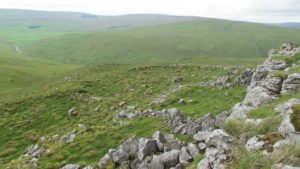
Fuke Well, Pudsey, West Yorkshire

Healing Well (destroyed):  OS Grid Reference – SE 22 33

Archaeology & History

Ths curiously-named site is described just once in very early field-name records as the ‘Fukewell’.  Included in A.H. Smith’s (1961) magnum opus, he passes over the place-name without comment.  But in finding his 12th century literary source, we read that it was located on some land given to the monks of Kirkstall Abbey, Leeds.  Written in early disjointed Latin, we find that the Fukewell was mentioned on a grant that described five acres of land given by one Adam Samson to the monks of the Abbey.  On one of the acres was a site known as the Cold Well, whilst the Fuke Well was found on a piece of land adjacent to a house, but its precise location seems to have been lost.  Nothing is mentioned about it by great Pudsey historan Simeon Raynor, despite him naming a number of other wells in the area – so we must presume that the site had already gone when he came to write his work.

But what does the word fuke actually mean?  There is nothing to explain it in Wright’s Dialect Dictionary, nor other regional dialect or place-name works.  I was wondering if it derived from the old english word ‘fuck’, which was common parlance in earlier centuries.  ‘Fucking’ was a word that didn’t have the debased christian ideology attached to it: of something not to be talked about, or be hidden.  To have a fuck, or go fucking, was always quite normal; and to most people in the real world we use the same term with absolute ease – because we all do it!  But this etymological idea is pure speculation on my part.  Can anyone give clear light to fuke’s real meaning?

References:

  1. Fryer, Peter, Mrs Grundy, Dennis Dobson: London 1963.
  2. Lancaster, W.T. & Baildon, W. Paley (eds.), The Coucher Book of the Cistercian Abbey of Kirkstall, Thoresby Society: Leeds 1904.
  3. Smith, A.H., The Place-Names of the West Riding of Yorkshire – volume 3, Cambridge University Press 1961.

© Paul BennettThe Northern Antiquarian 

Gawk Hall Stone, Middleton Moor, North Yorkshire

Cup-Marked Stone:  OS Grid Reference – SE 13004 53097

Getting Here

Gawk Hall Stone

Probably the easiest route to find this is via the Roman Road from Blubberhouses. Go up Cooper Lane a few hundred yards, turning right (west) on the footpath past the Manor House and onto the moor. Walk along the footpath until you hit the dead straight Roman Road and walk 1⅓ miles (past the cup-marked Eagle Stone) until you meet another footpath on your right veering over the haunted Sug Marsh away from the straight road. This takes you to Gawk Hill Gate ½-mile away. Go over the wall here and walk for 350 yards where several stones are just yards to the left of the path. You’re there!

Archaeology & History

…and again!

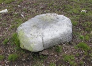
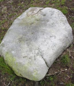
Depending on the age of the old path by which this carving lies, it may have represented a marker of the ancient route.  It lives in relative isolation from other petroglyphs a mile or so further down the moorland slopes and is probably one only for the purists amongst you.  A smoothed (female) medium-sized rock, about 2 yards by 1 yard across, possesses at least two simple cup-marks on its upper western surface. A third cup seems evident between the main two cups, with a carved line running some 10 inches towards the eastern side of the stone.  What may be several other cup-marks can be seen on the stone, but the day was overcast when we came here and so we’re unsure as to whether they’re natural or man-made.

Acknowledgements:  Many thanks to James Elkington and his little compatriot Mackenzie, who accompanied us to this and other sites nearby.

© Paul BennettThe Northern Antiquarian

Heygate Stone, Baildon, West Yorkshire

Cup-and-Ring Stone:  OS Grid Reference – SE 15942 40187

Archaeology & History

Heygate Stone

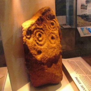
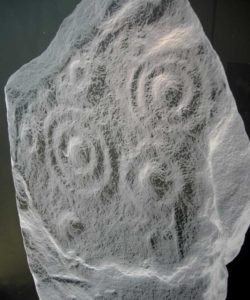
This excellent cup-and-ring marked petroglyph was found fortuitously in September 2001 by the land-owner at Near Hey Gate field to the northeast of Baildon village.  He was clearing out remains of some old walling in the field and, adjacent, a rock that was protruding out of the ground got turned over.  Underneath it he noticed a series of very well-preserved cups and rings in a cluster near one part of the rock.  It was a bittova beauty to be honest!

Thankfully due to the subsequent efforts of local rock art students Mike Short and Keith Boughey, it was later re-housed in the Brackenhall Centre at the edge of Shipley Glen.

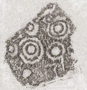
Enhanced rendition of Keith Boughey’s Heygate Stone rubbing
Computer-enhanced image of the carving

The stone itself was once larger than it now is and may have had additional carved elements on it, but the other portion that had broken off wasn’t located when it was first dug out of the ground.  This may mean that it was moved here from another location, which would have been somewhere close by.  Many other petroglyphs exist in and around the Baildon district.As we can see in the images here, two very well-defined double cup-and rings have clusters of smaller singular cup-and-rings around their edges.  A single cup-mark was etched below the largest of the double-ring carving, and what seems like a carved straight line emerges from the largest of the single cup-and-ring.

References:

  1. Griffiths, Kathie, “Historic Stone Back Home on Moors,” in Telegraph & Argus, 11 November, 2006.
  2. Short, Mike, “The Heygate Stone,” on Megalithic Portal, 21 November, 2006.

Acknowledgements:  Big thanks to Mike Short for his info and to Keith Boughey whose rubbing I’ve touched-up and used in the site profile.

© Paul BennettThe Northern Antiquarian

Holy Well, Baildon, West Yorkshire

Holy Well (destroyed):  OS Grid Reference – SE 1609 3961

Archaeology & History

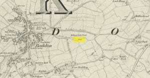
This site is all but unknown to the great majority of folk in Baildon, and even some of the local historians have let it slip from their investigative tendrils.  According to the primary Baildon historian, W.Paley Baildon, it was first known as the ‘Halliwell Holy Well’.  In his magnum opus (1913-26) of the township he relates that,

“The 1852 Ordnance map marks Halliway Banks Wood to the south of Langley Lane, with a well just below it, and a footpath from Holden Lane to the well.  Halliway, I think, is a corruption of Halliwell, the ‘holy well,’ with the special footpath leading to it and nowhere else.  Haliwell Bank occurs in (the Baildon Court Rolls of) 1490, when it formed part of the property held by William Tong of Nicolas Fitz William.”

This etymology is echoed by the great place-name authority A.H. Smith (1954).  It also caught the attention of archaeologist Andrea Smith (1982), in her investigation of twenty-five holy wells in the West Yorkshire region.

“Many wells,” she wrote, “are recorded simply as ‘Holy Well,’ or the various forms ‘Halliwell,’ ‘Helliwell’ and ‘Hollowell.’  It is possible that in these instances the identity of the patron saint or guardian of the well has been forgotten, which may be the case with the site at Collingham, now known as Hollowell.”

Site of the Holy Well in 1852

The well itself can no longer be seen.  When I looked for the site in 1982, I found that to the right of where the 1852 map showed it, was a waterworks lid covering the old holy waters, just in the trees atop of the field beneath a great sycamore with a number of small stones roughly encircling the site: perhaps the only possible relics of the century before when the waters would have been used.  A stone trough was situated at the bottom of Holden Lane, fed by the waters from the Halliwell and from here the course of the stream meandered down the side of Slaughter Lane, now known as Kirklands Road.  The land around Halliwell became known as Kirkfield, or field of worship.

A local resident told how during autumn and winter, the left side of the field gets extremely boggy – the region were the old stream ran from the old well, along which dowsers have found aquastats abound.  Now however, houses have been built where the waterworks-lid used to be and is likely to be in someone’s backyard, all but forgotten.

Folklore

According to local lore, the site of this most ancient of holy wells was found in the warmest place in the Baildon district.  Whilst its geographical position doesn’t necessarily suggest this (although it did face south, into the sun), this lore may reflect some healing aspect of the well that has long since been forgotten.

Perhaps relevant to Andrea Smith’s comment about there being ‘guardians’ at holy wells is found in folklore relating to nearby Holden Lane: locals in the last century also referred to it as Boggart Lane, so called after the Boggart which was seen there in the form of a spectral hound that was said to possess large glowing red eyes and was a sign of ill omen.  Modern sightings of the spectral hound, which appeared along the road which led to the old well, are unknown.

References:

  1. Baildon, W. Paley, Baildon and the Baildons (parts 1-15), St. Catherines: Adelphi 1913-26.
  2. Smith, A.H., English Place-Name Elements – volume 1, Cambridge University Press 1954.
  3. Smith, Andrea, ‘Holy Wells Around Leeds, Bradford & Pontefract,’ in Wakefield Historical Journal 9, 1982.

© Paul BennettThe Northern Antiquarian


Lower Headley Farm, Thornton, Bradford, West Yorkshire

Tumulus (destroyed):  OS Grid Reference – SE 099 321

Archaeology & History

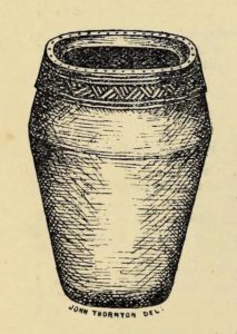
Headley Farm urn

There are no longer any remains of the prehistoric burial site that once stood in one of the fields by Lower Headley Farm.  We don’t know whether the site was a cairn, a tumulus, or just a stone-lined cist; but in all probability it would have been a low rounded hillock whose existence had long since fallen out of oral tradition.  All that we do know is that in one of the fields by the farm, some very well preserved urns—either neolithic or Bronze Age by the look of it—were unearthed, indicating a site of prehistoric provenance.

The finds were described only briefly in the first edition of the Bradford Antiquary (1888) journal, where it was reported:

“During the spring of 1880 an interesting discovery was made by Mr. Abraham Craven, quarryman, of Thornton.  The ‘find’ comprised three funeral urns, which Mr. Craven turned up while baring a portion of a field in Lower Headley Farm, the property of the trustees of Sowerby Grammar School.  The discovery was made within a short distance of the surface, the pottery presenting undoubted indications of pre-Roman origin.  From evidence collected upon the spot, and the appearance of the pottery, two of the urns were about 14in in height, 9in across the top, 11½in at the widest portion of the bowl, and 6in at the foot.  One of the urns was of sun-burnt clay, with rude markings, the other having evidently been subjected to fire.  No coins, personal ornaments, or other indications of civilisation, were found in the urns, but each one contained human dust and bones.  From the fact that several other urns have been met with in the immediate vicinity, equally rude in type, evidence is not wanting that the picturesque mound upon which Headley is situate was inhabited at a very early period of British history.”

References:

  1. Anonymous, “Valuable ‘Find’ at Headley, near Thornton,” in Bradford Antiquary, volume 1, 1888.

© Paul BennettThe Northern Antiquarian


Bedford Hill, Tooting, Surrey

Tumulus (destroyed):  OS Grid Reference – TQ 288 726

Archaeology & History

This long lost prehistoric tomb is one of many that has fallen under the destructive hammer of the christian Industrialists in this part of the country.  Located somewhere in the parkland grounds of Bedfordhill House (also destroyed), its memory was thankfully preserved by the renowned folklorist and historian Walter Johnson (1903) who wrote of it in his work on prehistoric Surrey, where he told:

“A few years ago a supposed barrow was levelled in Bedford Park, Bedford Hill, Tooting, and no record taken of the results. The mound was enclosed in the Park for several  centuries, but when the grounds were laid out for building purposes ten or a dozen years since, it suffered rough usage, and was finally destroyed. It was nearly 100 yards long, and about 20 feet in breadth in its highest part.  It ran East and West, and had several trees growing on it before its desecration….  A moat had been made round the mound for about two-thirds of its circuit.  This moat was supplied with water by the Ritherdon, a small stream rising in Streatham.  The name is preserved in the adjacent Ritherdon Road.  The material of the mound was gravel and gravelly loam, which, in the neighbourhood, occurred only in a thin layer, thus forbidding the conclusion that the structure was merely composed of the soil dug out in making the moat. The excavated material would largely be London Clay.  As the genuineness of this barrow was, we believe, called in question after its demolition, when the subject was beyond reconsideration, we mention two shreds of collateral evidence. The ground on which the tumulus stood was about the highest in the district. The name Tooting may also have some bearing, for Mr. Clinch thinks that it was a Celtic settlement where was worshipped the deity known as Taith. (Compare also toot-hill, as exemplified in Tot Hill, Headley, Tothill Fields, Westminster, famous for fairs and tournaments, also Tutt Hill, near Thetford.)”

The ‘toot’ in Toothill however, is ascribed by Gover, Mawer & Stenton (1934) as being the usual “look-out hill”.  Although they do make note of the fact “that there is no hill in Tooting which would make a good look-out place.”  But if this was a large barrow of some type, it would explain the etymological oddity.  Any further information on this site would be welcome.

References:

  1. Gover, J.E.B., Mawer, A. & Stenton, F.M., The Place-Names of Surrey, Cambridge Univserity Press 1934.
  2. Johnson, Walter, Neolithic Man in North-East Surrey, Elliot Stock: London 1903.
  3. Smith, A.H., English Place-Name Elements – volume 2, Cambridge University Press 1954.

© Paul BennettThe Northern Antiquarian


Tumble Beacon, Banstead, Surrey

Tumulus:  OS Grid Reference – TQ 2432 5902

Archaeology & History

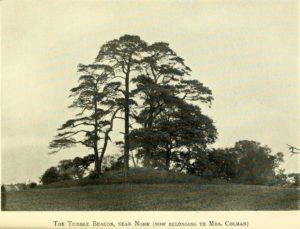
Tumble Beacon in 1911

This ancient “bowl barrow” as the modern archaeo’s are wont to describe it, is a Bronze Age tumulus that has seen better days.  But at least it’s still there – albeit slightly damaged and enclosed by modern housing, in the back of someone’s garden.  I expect that if you were to ask the owners, it would be OK to see this 4000 year old burial mound (in Scotland at least, we always find people very amiable when it comes to asking such things).  It’s quite a big thing too, so you can’t really miss it!  Standing more than 12 feet high, it rises like an archetypal fairy mound—now out of place—measuring some 38 yards east-west and roughly 44 yards north-south.

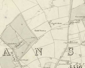
Highlighted on the early OS-map of the region, the name of the site indicates its multi-period usage, with the ‘beacon’ element derived  from when, in 1594, a fire was lit upon it to tell of the arrival of the Spanish Armada.  Whether it had been used as a beacon prior to that, I can find no historical accounts.  One of the early archaeological descriptions came from the pen of the old historian and folklorist, Walter Johnson (1903), who told us simply:

Tumble Beacon on 1871 map
Walter Johnson’s 1903 sketch

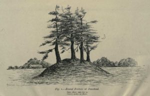
“About a mile South-west of Banstead Church, in a field close by Tumble Farm, on the outskirts of Nork Park, is an eminence marked on the map as Tumble Beacon.  A picturesque clump of pines stands on the mound, which, from its general character, and from the flint scraps we have found there, we have every reason to believe is a round barrow, despite the local tradition that it is a ‘sea-mark.’  The Scotch pines, in such positions as we find here, may probably, Mr. Grant Allen thought, be the descendants of trees put in by human hands when the barrow was first raised.”

Whilst this latter idea might be very hard to prove, the assertion that it’s prehistoric certainly gained favour as more antiquarians examined the site.  Johnson later told that when examining this and other sites nearby (sadly destroyed) he came across a variety of prehistoric stone utensils in the area.

References:

  1. Gover, J.E.B., Mawer, A. & Stenton, F.M., The Place-Names of Surrey, Cambridge Univserity Press 1934.
  2. Grinsell, Leslie V., The Ancient Burial Mounds of England, Methuen: London 1936.
  3. Johnson, Walter, Neolithic Man in North-East Surrey, Elliot Stock: London 1903.
  4. Lambert, H.C.M., History of Banstead in Surrey, Oxford University Press 1912.

© Paul BennettThe Northern Antiquarian


Cloven Hoof Well, Shipley Glen, West Yorkshire

Sacred Well:  OS Grid Reference – SE 12839 39331

Also Known as:

  1. Raygate Well

Getting Here

Cloven Hoof Well, Shipley Glen

On the roadside at Shipley Glen, from Brackenhall Circle walk up for about 250 yards, where you’ll notice the land dips as it drops into the woods below. Follow this dried stream down until you reach the mossy Loadpit Beck in the valley.  By the waterside is a footpath: follow this upstream for a short distance, keeping your eyes peeled on the Earth below where a smaller stream crosses the path you’re walking on.  Follow this uphill to its source!

Archaeology & History

Halfway up (or down) the moss-covered waters of Shipley Glen the all-but-forgotten waters of the Cloven Hoof Well still flows nice and freely, and is still good to drink. It was shown on the first OS-map of the area in 1852, where it was called the Raygate Well, whose derivation neither the great Baildon historian W. Paley Baildon nor the place-name giant A.H. Smith could account for.  It sounds just like it was someone’s surname, but local genealogy cannot affirm this.  One possibility—and which reflects in the local lore of the site—is that it’s a compound word from the old northern dialect word Rea, “an evil spirit or demon”, and gate, “a hole, an opening or gap.”  The terms are used in a prayer given in Mr Sinclair’s Satan’s Invisible World Displayed (1814),

“as recited in the time of Popery by persons when going to bed, as a means of them being preserved from danger:

“Keep this house from the weir…
And from an ill Rea,
That be the gate can gae.””

But this purely speculative….

Cloven Hoof Well on 1852 map

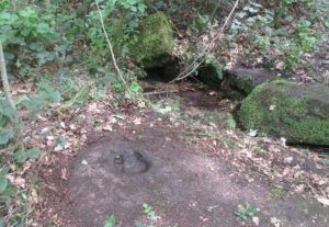
A photograph and brief description of the Cloven Hoof Well was given in an early edition of the Bradford Scientific Journal after a geological excursion to Shipley, though nothing was said of its curious name. However on a rock below the spring, a hoof-print mark is clearly seen.  It appears to be part-natural and partly enhanced.  This is an area rich in prehistoric petroglyphs, or cup and rings stones.

Mosses thankfully still cover the rocks from whence the waters flow; and bilberry, blackberry, male fern and bracken also grow around it.  Psychoactive plants also abound nearby. The water is healthy and never seems to dry up, even during long warm summers.  And below here, on the other side of the stream at the bottom, you can visit the little-known Wood Well

Folklore

Local lore told that the devil stepped here and left his hoof-mark in the rock, making the waters rise from the Earth.  Possibly a venerated site in earlier days, one finds numerous ancient remains nearby (cup and rings, stone circle, walling, cairn fields).  Pagans amongst you should love this place!

References:

  1. Armitage, Paul, The Holy Wells and Healing Springs of West Yorkshire, forthcoming
  2. Baildon, W. Paley, Baildon and the Baildons (parts 1-15), St. Catherines: Adelphi 1913-26.
  3. la Page, John, The Story of Baildon, William Byles: London 1951.

© Paul BennettThe Northern Antiquarian


Clowder (1), Arncliffe, North Yorkshire

Enclosures:  OS Grid Reference – SD 9165 6968

Also Known as:

  1. Clouder

Getting Here

Looking down on Clowder-1

To the right of The Falcon Inn across from Arncliffe village green is a trackway called the Monk’s Way.  Walk up here for about 450 yards until there’s a stile on your right which is the start of the diagonal footpath SW up the hillside.  Once you hit the limestone ridge several hundred yards up, keep on the path that curves round the edge of the hill for 1.3 miles (2.1km), going over 5 walls until, at the 6th one, you should look uphill, east, at the small cliff-face 100 yards above you.  That’s where you need to be!

Archaeology & History

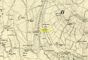
This is one of several clusters of large prehistoric enclosures and settlements in the expanse of land known as Clowder, on the hills 1.65 miles (2.63km) southwest of Arncliffe.  It’s in a very good state preservation and, surprisingly, almost nothing has been written about it.

Covered hut circle on NW edge
Cliffs & walls of Clowder-1

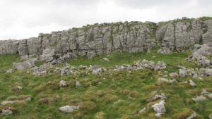
A multi-period site whose construction probably began  sometime in the Iron Age (although the old Yorkshire Dales archaeologist, Arthur Raistrick, thought the settlements up originated in the Bronze Age), we can say with some certainty that parts of this complex were definitely being used until medieval times due to the lack of growth on some of the walling.

The entire complex comprises of a series of interlinked walled enclosures running roughly north-south for a distance of more than 200 yards.  Along the 200 yards are at least eight conjoined walled sections of varying shapes and sizes.  Some of the walling, particularly along its western edges, measuring up to 10 feet across (some of this will be due to collapse) is very overgrown indeed and is probably the oldest aspect of the enclosure.  The inner walled sections, much of it leading up to the small cliff face, are rough rectangular structures, each of them averaging 30 yards from their western edge to the eastern cliff and rock faces.

Most recent walled section

Within the largest and best preserved section at the northern end, a smaller and more recent walled rectangular enclosure would seem to have been used for either cattle or storage of some form, as it’s on too much of a slope to have been viable as a living quarter.  Also on the very northern edge is a well-preserved but much overgrown hut circle, between 8-9 yards across.

Faint walling looking south

The entirity of Clowder-1 is difficult to assess without an archaeological dig.  Despite this, as half of the walled enclosures (in the northern half) are on slopes leading up to the cliffs they would seem unsuitable for people to live in.  It is more probable that these sections were used for livestock and other storage.  At the more southern end however, the land begins to level out and this would be feasible as good living quarters.  There was also once a good source of water immediately beneath the entire complex, but with deforestation the waters eventually fell back to Earth.Back to its southern end and down towards the modern-day walling, some 70 yards on we find more ancient structures of the same architectural form that we’ve just walked along.  This lower section has just one notable singular oval-shaped hut circle, 20 yards east-west by 29 yards north-south.  Other probable man-made structures seem to be just below this; and this part of the settlement then continues on the other side of the walling, into the large Dew Bottoms (5) settlement complex.

Folklore

Weather lore of the ‘Clauder’ hill tells that it “draws the skies down” – i.e., as Halliwell Sutcliffe (1929) put it:

“A deluge may be in process on each side of the Clouder when lower down the sun is hot on tired pastures.”

We encountered just such a truth when James ElkingtonChris Swales and I visited the sites up here just a week or so ago…

References:

  1. Dixon, John & Phillip, Journeys through Brigantia – volume 2, Aussteiger: Barnoldswick 1990.
  2. Sutcliffe, Halliwell, The Striding Dales, Frederick Warne: London 1929.

Acknowledgements:  Huge thanks to James Elkington and Chris Swales, without whose guidance this site profile would never have been written.

© Paul BennettThe Northern Antiquarian

St. Peter’s Well (2), Leeds, West Yorkshire

Holy Well (destroyed):  OS Grid Reference – SE 308 336

Archaeology & History

St Peters Well locale in 1852

This is one of three wells that were dedicated to St Peter in the Leeds district.  The first of them, near the city centre, was described by the northern antiquarian Ralph Thoresby (1715) as being in St. Peter’s Square—which has now been completely built over, but was situated “at the bottom or west end of High Street,” (Bonser 1974) about 50 yards west of the modern Quarry Hill buildings.  It was well known in the area in early times with a good curative reputation due seemingly to its sulphur content.  Mr Thoresby told that us, it

“is intensely cold and very beneficial for such as are afflicted with rheumatic pains, or weakness, rickets, etc, for which reason it is much frequented by such, who might otherwise have recourse to St. Mungus or Mongah, as it is more truly writ. This Spring, according to St Anselms Canon, which forbad a credulous attributing any reverence, or opinion of holiness to fountains…must either have been of great antiquity, or have had the bishop’s authority.”

Local folk of course, would have long known the goodness of this water supply long before any crude bishop.  The well either possessed a very large stone trough or it had been fashioned and added to by locals, as Thoresby reported “trying the cold bathing of St Peter’s.”  He took his youngest child there, Richard, to help him overcome an osteopathic ailment.  In his diary entry for April 8, 1709, he wrote:

“Was late at church, and fetched out by a messuage from the bone-setter (Smith, of Ardsley), who positively affirms that one part of the kneebone of my dear child Richard, has slipped out of its proper place; he set it right and bound it up; the Lord give a blessing to all endeavours!  We had made use of several before, who all affirmed that no bone was wrong, but that his limp proceeded rather from some weakness, which we were the rather induced to believe, because warm weather, and bathing in St. Peter’s Well, had set him perfectly on his feet without the least halting, only this severe Winter has made him worse than ever.”

It later became at least one of the water supplies for Maude’s Spa close by.  As usual with health-giving waters at this period in the evolving cities, money was to be made from them and local folk had to find their supplies from other sources.  St Peter’s Sulphur Baths (as it was called) were built on top of it in the 19th century and, said Bonser “flourished until the early years of the (20th) century.”

Although I can find no notices of annual celebrations or folklore here, St. Peter’s Day is June 29 — perhaps a late summer solstice site, though perhaps not.

It would be good if Leeds city council would at least put historical plaques in and around the city to inform people of the location of the many healing and holy wells that were once an integral part of the regions early history.  Tourists of various interest groups (from christian to pagan and beyond) would love to know more about their old sacred sites and spend their money in the city.

References:

  1. Atkinson, D.H., Ralph Thoresby, the Topographer – volume 1, Walker & Laycock: Leeds 1885.
  2. Baines, Edward, The Leeds Guide, E.Baines: Leeds 1806.
  3. Bonser, K.J., “Spas, Wells and Springs of Leeds,” in Publications Thoresby Society, 54:1, 1974.
  4. Harte, Jeremy, English Holy Wells – volume 2, Heart of Albion: Wymeswold 2008.
  5. NiBride, Feorag, The Wells and Springs of Leeds, Pagan Pratlle: Leeds 1994.
  6. Robinson, Percy, Relics of Old Leeds, P.Robinson: Leeds 1896.
  7. Smith, Andrea, ‘Holy Wells Around Leeds, Bradford & Pontefract,’ in Wakefield Historical Journal 9, 1982.
  8. Thoresby, Ralph, Ducatus Leodiensis, Maurice Atkins: London 1715.
  9. Whelan, Edna & Taylor, Ian, Yorkshire Holy Wells and Sacred Springs, Northern Lights 1989.

© Paul BennettThe Northern Antiquarian