St. Philip’s Well, Keyingham, East Yorkshire

Holy Well (destroyed):  OS Grid Reference – TA 23584 25549

Archaeology & History

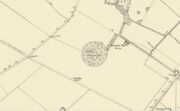
The Well shown on the 1855 6″ OS map

This holy well was formerly on the northern boundary of a field adjoining the north side of the A1033 west of Keyingham.

In view of the surviving folklore relating to the well it seems that its dedication to St. Philip may have been an effort by the Church to ‘Christianise’ it; and the St Philip here is not the Biblical Apostle, but a local saint – Philip Ingleberd (died c.1325 and also known as Philip Inglebred), whose memory was celebrated by a nearby Cross and a shrine at St Nicholas Church in the village.  The well and the cross may have been dedicated some time after 1392 following a ‘miracle’ relating to Philip’s tomb.  These were destroyed by the mob in the Reformation, although the cross-base survives.  It seems the well may have been restored in the late seventeenth century.  By the early twentieth century the well was described as laying on the Common to the west of the village, by then filled in, only showing signs it ever existed by making the ground near its site wet and boggy in a rainy season.

Folklore

George Poulson writing in 1841 told that,

“…a few fields more to the west is a well, called St. Philip’s Well; on a small stone are inscribed W. H. W. D. IG67. W. K.  It is called the wishing well; and the country lasses were in the habit of dropping pins, or even a sixpence into it, for the purpose of ensuring to themselves either particular or general good luck.”

William Smith (1923) described the well as one of six wishing wells or pin wells in Yorkshire and, moreover, the only ‘Cross Well’ in the East Riding.  At none of these wells was evil allowed to be foreshadowed, and the wells were only to show to a girl the portrait of her future husband.  He told us that,

“In every case the wish had to be with truthful devotion, and not divulged to any living person, or the desired consummation would not be gained…. Tradition adds that the well was much visited by maidens, who, on dropping their pins or coins, expressed the wish to see their lovers mirrored on its waters. Thus they kept a custom, dating to the time when the well was counted to be under the control of the fairies.”

And as Keyingham Common was once the abode of the fairies, it is worth noting that some 700 yards west of the site of the well a ‘Pans Hill’ is shown on the old maps, although whether this rural spirit of classical myth ever made it up to the East Riding is altogether another matter….

References:

  1. Arrowsmith, Nancy & Moorse, George, A Field Guide to the Little People, Macmillan: London 1977.
  2. Hope, Robert, Legendary Lore of the Holy Wells of England, Elliot Stock: London 1893.
  3. Poulson, George, History and Antiquities of the Seigniory of Holderness, Thomas Topping: Hull 1841.
  4. Smith, Rev. William, Ancient Springs & Streams of the East Riding of Yorkshire, A.Brown: Hull 1923.

© Paul T Hornby 2021
St. Hilda’s Well, Whitby, North Yorkshire

Holy Well (destroyed):  OS Grid Reference – NZ 9006 1102

Archaeology & History

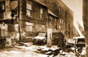
Virgin’s Pump, c.1890

This is one of at least five wells dedicated to St. Hilda in North Yorkshire that my old colleague Graeme Chappell has uncovered over his many years of research.  It’s sadly been destroyed, and accounts of it seem to be few and far between; but from the short description of it by Mr J.C. Atkinson (1894)—and helped out by its later title—we at least know where it once was.

In his account of the old roads in the village, Grape Lane was mentioned as far back as 1396, and close by, he wrote,

“is a spring called Seynt-Hild-keld, possibly where the so-called “Virgin pump” stands, or stood, not so very long since.”

This ‘ere “virgin pump” is shown in an old photo taken about 1890, just round the corner from Grape Lane where, today, is the car park on Church Street, opposite The Endeavour.

Folklore

St Hilda was a 7th century saint who was reputed to have founded Whitby Abbey.  Her festival date was November 17.

References:

  1. Atkinson, J.C., Memorials of Old Whitby, MacMillan: London 1894.

© Paul BennettThe Northern Antiquarian

Allington Hill, Bottisham, Cambridgeshire

Tumulus (destroyed):  OS Grid Reference – TL 5801 5874

Archaeology & History

Site marked on 1886 map

In times of olde on this prominent tree-covered hill, a tomb of some ancient ancestor once lived.  It had already been destroyed by some retards by the time the Ordnance Survey lads came here in 1885; but thankfully, memory gave its existence the note it deserved.  The place had thankfully been given the once-over by some archaeologists in the middle of that century, giving us a pretty good idea as to its size and nature.  Measuring some 90 feet across and fourteen feet high, this was no mere toddler!

A Mr W.T. Collings (1846) gave his Intelligence Report to the archaeological journal of the period, from which the following description is gained:

“The excavation of this tumulus in 1845 was made from east to west, commencing from the eastern side, in the direction of its centre, in which, at a depth of about three feet, there was found a cinerary urn in an inverted position, slightly tilted on one side, and surrounded by charcoal and burnt earth.  It was filled with charcoal, but contained only one small fragment of bone. This vessel, which was of the simplest manufacture, moulded by the hand, and sun-baked, measured in height five inches, and its diameter at the largest part was five inches and a half.  From the deep red colouring, and the general appearance of the surrounding soil, it would seem that a small hole had been first dug, charcoal and bones burnt in it, the vase placed on the fire in an inverted position, and the whole covered up.  About ten feet eastward of the central deposit, on the south side of the line of excavation, and half a foot deeper, a deposit of fragments of bone was found apparently calcined, but with little charcoal or burnt earth, forming a layer not more than three inches thick, and two feet in circumference.  There were several pieces of the skull, a portion of the alveolar process, inclosing a tooth, apparently that of a young person, pieces of the femur and clavicle, and other fragments.  A little to the north of this spot there appeared a mass of charcoal and burnt earth, containing nothing of interest. After digging five or six feet deeper, operations were discontinued; and on the next day shafts were excavated from the centre, so as completely to examine every part, without any further discovery, and in every direction charcoal was found mingled with the heap, not in patches, but in fragments.”

Collings reported the existence of another burial mound a short distance to the south.  It was one of at least five such tumuli in the immediate locale, all of which have been destroyed by retards in the area.

References:

  1. Collings, W.T., “Archaeological Intelligence,” in Archaeological Journal, volume 3, 1846.
  2. Hore, J.P., The History of Newmarket – volume 1, A.H. Baily: London 1886.
  3. Royal Commission Ancient Historical Monuments, Inventory of Historical Monuments in the County of Cambridgeshire – Volume 2: North-East Cambridgeshire, HMSO: London 1972.

© Paul BennettThe Northern Antiquarian

Oliver’s Mound, Richmond Park, Surrey

Tumulus (destroyed):  OS Grid Reference – TQ 192 735

Also Known as:

  1. Oliver’s Mount

Archaeology & History

Roque’s 1746 map

Oliver’s Mound was highlighted as early as 1746 on John Roque’s map of the Country Near Ten Miles Round (London) as still standing.  One hundred and fifty years later, when the Ordnance Survey lads came to map the area, it had gone.  We don’t know exactly when it was demolished, so Historic England (not necessarily a good measure of accuracy) tell us its demise occurred “between 1760 and 1868”, so giving themselves at least some degree of safety!

As we can see in Mr Roque’s old map, an avenue of trees led up to the barrow.  This avenue will have been created when Richmond Park and its gardens were laid out.

The round barrow was most likely Bronze Age in origin.  The historian and folklorist Walter John (1093) reported that in 1834, three skeletons were found at a  depth of a yard beneath the surface.

Folklore

Site shown on 1873 map

Traditional tells that the name of this barrow comes from when the religious extremist, Oliver Cromwell, and his men, set up camp here.  A slight variant tells that Cromwell stood here to watch a skirmish.

References:

  1. Cundall, H.M., Bygone Richmond, Bodley Head: London, 1925
  2. Grinsell, Leslie V., The Ancient Burial Mounds of England, Metheun: London 1936.
  3. Johnson, Walter, Neolithic Man in North-East Surrey, Elliot Stock: London 1903.
  4. Johnson, Walter, Folk Memory, Clarendon: Oxford 1908.

© Paul BennettThe Northern Antiquarian

Caesar’s Camp Barrow, Wimbledon, Surrey

Tumulus (destroyed):  OS Grid Reference – TQ 222 709

Archaeology & History

It seems that a great number of prehistoric remains used to exist in and around the Wimbledon Common area.  This one is mentioned only briefly in Thomas Stackhouse’s (1833) rare work on early British remains, where he wrote:

“Near an old single-trenched Camp at the South West comer of Wimbledon Common, is a very small flat Barrow cut into the form of a cross: I don’t know that it has been noticed by any writer.”

The “single-trenched Camp” he described is today known as Caesar’s Camp hillfort.  By the time the Wimbledon historian William Bartlett (1865) came to write his survey, the site had been destroyed.  In Mr Johnson’s (1903) survey, he seems to confuse this site with the large barrow cemetery that used to exist on the northern edges of Wimbledon Common described by William Stukeley and others.

(the grid-reference to this site is an approximation).

References:

  1. Bartlett, William A., The History and Antiquities of Wimbledon, Surrey, J. & S. Richards: Wimbledon 1865.
  2. Johnson, Walter, Neolithic Man in North-East Surrey, Elliot Stock: London 1903.
  3. Stackhouse, Thomas, Two Lectures on the Remains of Ancient Pagan Britain, privately printed: London 1833.

© Paul BennettThe Northern Antiquarian

Cedars Road, Clapham, Surrey

Tumulus (possible):  OS Grid Reference – TQ 2856 7555

Also Known as:

  1. Mount Nod

Archaeology & History

Located on the old boundary line between Clapham and Battersea, what might have been a forgotten tumulus, whose memory was thankfully preserved by the renowned folklorist and historian Walter Johnson (1903), was described in his work on prehistoric Surrey.  He seemed to think it serious enough to add to his survey, where he told us that,

“there still exists, near Cedars Road, Clapham, what may possibly be a round barrow.  It is in the garden of a house opposite St. Saviour’s Church, and is visible to anyone passing along the old, narrow passage called Wix’s Lane.  Mr. J.W. Grover, who brought the matter before the Archaeological Association in 1884, had been struck by the discovery that old maps marked the spot ‘Mount Nod Fields.’  …The mound must originally have been 70 or 80 feet across, but had been tampered with on one side for the construction of an ice-house.  Mr. Grover suggested that the mound may be of Celtic date.  To us, the height—some 12 feet or more—together with marked signs of reconstruction at a comparatively modern date, indicate the necessity of withholding judgment. The original tumulus may simply have been increased in height, but…digging alone could settle the question.”

Local historian Michael Green (2010) has found that there were prehistoric tombs on Clapham Common only 500 yards away, so this one along Cedar Road was not in isolation.  Is the site named on the boundary perambulation records?  Has it been explored since Johnson wrote about it and, if so, has its veracity as a prehistoric tomb been ascertained, or is it merely the remains of some post-medieval creation?

References:

  1. Green, Michael, “Mount Pond, Clapham Common: Archaeology and History“, Clapham Society Local History Series, 2010.
  2. Grover, J.W., “Mount Nod, Clapham,” in Journal of the Archaeological Association, volume 40, 1884.
  3. Johnson, Walter, Neolithic Man in North-East Surrey, Elliot Stock: London 1903.

© Paul BennettThe Northern Antiquarian

Cragganester (11), Kenmore, Perthshire

Cup-Marked Stone:  OS Grid Reference – NN 65858 38750

Getting Here

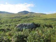
Cragganster 11 in situ

From Killin, take the A827 road to Kenmore. 6 miles along, on your right, is the track down to the Big Shed at Tombreck.  Keep on the A827 for exactly ⅓-mile (0.53km), and opposite the driveway to Craggantoul is a small parking spot.  A few yards on the road, over the burn, go thru the gate on your left.  Follow the straight line of walling up for 400 yards it meets where another line of walling running right (E), into the boggy pasture-lands. Walk along here for roughly another 400 yards then go up the slope as if walking up Ben Lawers (N).  You’ll come to 2 large boulders next to each other where the slope levels out.  It’s the one on your left!

Archaeology & History

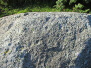
This carving is really for the purists amongst you.  It’s like most of the carvings along this contour line in that the design is simplistic.  Consisting of at least nine cups all on top of the stone, they can be difficult to see amidst the rough garnet and lichen-encrusted rock.

Cupmarks on its west face
Looking down on the cups

On one of our visits here, when the light cut across the surface at a lower angle, it seemed as if one of the cups had a faint ring around it; but it looked as if the outline of it had been started, but then for some reason the ring was never actually carved.  This outline is very faint.  We’ve found examples of this at two of the Duncroisk carvings, several miles to the west, where the faintest trace of a ring was outlined, but never carved.  Of the cup-marks: five of them are carved on the east-side of the rock and are pretty easy to see (with the ring around one of them), whilst the other four—slightly more difficult to make out—are on its west side.  A couple of hundred yards north you can see the Cragganester 10 carving.

© Paul BennettThe Northern Antiquarian

Lambeth Wells, Lambeth, London, Surrey

Healing Wells (destroyed):  OS Grid Reference – TQ 3094 7889

Also Known as:

  1. Lambeth Spa
  2. Near Well and Far Well

Archaeology & History

This once famous healing or spa well has long gone.  It was located where the buildings that now constitute 104-105 Lambeth Walk presently stand: an area which the great London historian William Thornbury (1878) told was already “a favourite resort of Londoners, and celebrated for the variety of sweet-smelling flowers and medicinal herbs growing there,” complementing the healing waters before and during the spa craze.  The great herbalist John Gerard did his collections here.

I can find no information regarding its early use by our peasant ancestors, so its written history simply begins when it had been appropriated by those well-to-do up-market types who took this medicinal spring for their commercial gain in the early days of the trendy spas.  Supplied by two separate springs known as the Nearer and Farther Wells respectively, the Well House built here was “formally opened in April 1696” and subsequently had almost daily accompaniments of music, including French and country dancing!  But as the popularity of the Lambeth Spa increased, so did its problems.  Phyllis Hembry (1990) told that by July 1715, one visitor to the spa,

“was so depressed to find that the many people there were mostly rakes, whores and drunkards, idlers such as Guard officers, or young pleasure-seeker like attorneys’ clerks, mingling with loose women of the the meanest sort.  The Lambeth Wells also became a public nuisance, so a dancing license was refused in 1755.”

The so-called Great Room which had been the place of great occasions by spa users ended up being the meeting place “for Methodist meetings.” Oh how the winter nights must have flown by…..

There was a decided improvement in the years that followed and social events at the spa increased again.  It became what Thornbury said “was another place of amusement.”  The Lambeth Wells, he wrote,

“were held for a time in high repute, on account of their mineral waters, which were advertised as to be sold, according to John Timbs, at “a penny a quart, the same price paid by St. Thomas’s Hospital.” About 1750, we learn from the same authority, there was a musical society held here, and lectures, with experiments in natural philosophy, were delivered by Dr. Erasmus King and others. Malcolm tells us that the Wells opened for the season regularly on Easter Monday, being closed during the winter. They had “public days” on Mondays, Thursdays, and Saturdays, with “music from seven in the morning till sunset; on other days till two!” The price of admission was threepence. The water was sold at a penny a quart to the “quality” and to those who could pay for it; being given gratis to the poor.  We incidentally learn that there were grand gala and dancing days here in 1747 and 1752, when “a penny wedding, in the Scotch manner, was celebrated for the benefit of a young couple.”

By this time, a rival St. George’s Spa of had been created a short distance away on the parish boundary and with it, the popularity and attendance at Lambeth Wells began to decline.  By the end of the 18th century, the rot had truly set in and its days were finally numbered.

As for the medicinal properties of these wells, little seems to have been recorded.  Aside from repeating the common description of them being mineral waters, William Addison (1951) simply added that they were also purgative.

References:

  1. Addison, William, English Spas, Batsford: London 1951.
  2. Allen, Thomas, The History and Antiquities of the Parish of Lambeth, J. Allen: London 1827.
  3. Allen, Thomas, A History of the County of Surrey – volume 1, Isaac Taylor: London 1831.
  4. Foord, Alfred Stanley, Springs, Streams and Spas of London: History and Association, T. Fisher Unwin: London 1910.
  5. Hembry, Phyllis, The English Spa 1560-1815, Athlone Press: London 1990.
  6. Nichols, John, The History and Antiquities of the Parish of Lambeth, J. Nichols: London 1786.
  7. Rattue, James, The Holy Wells of Surrey, Umbra: Weybridge 2008.
  8. Sunderland, Septimus, Old London Spas, Baths and Wells, John Bale: London 1915.
  9. Thornbury, William, History of Old and New London – volume 6, Cassell: London 1878.

Links:

  1. Lambeth Wells on the Vauxhall History website

© Paul BennettThe Northern Antiquarian

Cow and Calf Stones, East Bierley, West Yorkshire

Crosses / Legendary Rocks (destroyed):  OS Grid Reference – SE 1975 2909

Archaeology & History

Site location at Cross House

Not to be confused with a much more renowned namesake above Ilkley, this was the name given to two old stones that once existed in the middle of the East Bierley hamlet (as it was then) southeast of Bradford.  They were two large boulders next to each other, not far from the early farmstead of Cross House (see map, right) and were described in James Parker’s (1904) historic collage of the area, where he informed us that:

“On the village green (are) the primitive large stones locally called the “Cow and Calf stones,” which used to be in days gone by a Preaching Cross and Market Cross.”

When William Cudworth (1876) described the place nearly thirty years prior, he only mentioned a single cross, telling us:

“There is a lane which has long been called Kirkgate at Birkenshaw, leading up to an ancient cross on the hill.  The fact of this cross being on the hill must have given rise to the name Kirk (church) gate, as there was not, until a few years ago, any church at Birkenshaw.  In a previous paper we had occasion to notice the existence of the cross as an evidence of a pre-church period.”

The meaning behind the name Cow & Calf is unexplained by our respective authors, although Cudworth’s citation of “the cross as an evidence of a pre-church period” is probably not without merit here.  It seems very likely that the animal names of the two large stones—akin to the Cow & Calf Rocks at Ilkley and others of the same name elsewhere in the country—that sat near the top of the hill, probably possessed a creation myth similar to others of the same name.  From this, it seems logical that local folk held the rocks as important, which would have obviously attracted the regressive attention of Church; so they stuck a cross here to christianize the place and in doing so ensured that local people could continue using the place as a meeting place.  This practice (as if you didn’t already know) was widespread.

Although Mr Cudworth seems to give the first real account of the place, field-name records of 1567 listed a ‘Cowrosse’, which may have been the “cross on the Cow” stone.  A.H. Smith (1961) listed the site and suggested the element –rosse may derive from a local dialect word meaning a marsh, but a ‘cow’s marsh‘ seems a little odd.  It is perhaps just as likely that an error was made in the writing of rosse instead of crosse.

References:

  1. Cudworth, William, Round about Bradford, Thomas Brear: Bradford 1876.
  2. Parker, James, Illustrated History from Hipperholme to Tong, Percy Lund: Bradford 1904.
  3. Smith, A.H., The Place-Names of the West Riding of Yorkshire – volume 3, Cambridge University Press 1961.

© Paul BennettThe Northern Antiquarian 

Blind Well, Sutton-in-Holderness, East Yorkshire

Healing Well:  OS Grid Reference – TA 1204 3306

Archaeology & History

Site of well on 1855 map

We don’t know for certain the precise whereabouts of this long lost healing well, but it would seem to be the one highlighted here (right) on the 1855 OS-map.  However, I think it equally possible that the small unnamed building, roughly halfway between the highlighted ‘Well’ and Spring Cottage, where the walling meets, could be the site in question.  It’s one or the other!

Folklore

When Thomas Blashill (1896) wrote of the Blind Well in his standard history work of the area, memory of it was already falling away.  In discussing where local people could wash and look after their health, he told that

“There was one place in the parish where washing seems to have been practised as a curative measure.  Down in the East Field, near to Spring Cottage Farm, was the Blindwell, to which the people had access. If they used its waters freely when suffering from sore eyes, their faith would probably be rewarded.”

References:

  1. Blashill, Thomas, Sutton-in-Holderness, William Andrews: Hull 1896.

© Paul BennettThe Northern Antiquarian