Brandy Well, Carlton, North Yorkshire

Holy Well (lost):  OS Grid Reference – NZ 52 03?

Archaeology & History

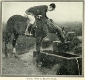
Brandy Well c.1910

Not marked on any map of the area (that I can find), this little-known possible holy well is described just once in one of Mr Blakeborough’s (1912) numerous regional history tomes.  Although he doesn’t explore the origin of the well’s name (which we find repeated at other water sources in northern Britain), the Scottish writers, Ruth & Frank Morris (1982) tell how examples of wells with this name in Scotland owe their names to the curious early christian figure of St. Brendan, whose annual saint’s day is May 16.  Whether this applies here I cannot tell.

We need some help locating the place, as it seems to have fallen off the radar.  The best I can do is give Mr Blakeborough description, who wrote of this Brandy Well:

“Speaking of superstitions reminds me of a tradition that the water in Brandy Well, half way up Carlton Bank, has most wonderful curative properties, and that a wish made here when drinking, is pretty certain to be fulfilled.  The well is by the road side and the water is no doubt just about as pure as it could possibly be, coming as it does, after much filtering through peat, straight from the hills.  There may be something more than mere superstition in the health giving properties of this water, especially in conjunction with the climb up the hill amid pine trees and the inhaling of the invigorating air.”

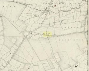
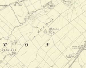
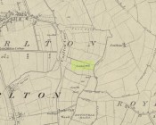
Its exact location is difficult to pin down.  There is no sign of any Well along the roadside between Carlton village and where the road eventually levels out on the northwest side of the hill.  It certainly isn’t the Mere Beck Spring on the south-side of the hill (is that still there and what is its history?); but there is however a ‘Spring’ shown on the early OS-maps on the east-side of the hill, along an old track at roughly NZ 52233 02357. Could this be it?  Or has the old Brandy Well been destroyed?  In an area littered with prehistoric and mythic sites, it would be good to relocate this one.

References:

  1. Blakeborough, J. Fairfax, Life in a Yorkshire Village, Yorkshire Publishing: Stockton-on-Tees 1912.
  2. Morris, Ruth & Frank, Scottish Healing Wells, Alethea: Sandy 1982.

© Paul BennettThe Northern Antiquarian


Market Cross, Halesowen, Worcestershire

Cross:  OS Grid Reference – SO 9666 8356

Archaeology & History

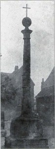
Halesowen Cross, when it stood in the village

Halesowen Cross, when it stood in the village

The history of this probable late-medieval monument is fragmentary.  It presently stands in the southeast corner of St John the Baptist churchyard, but used to be in the middle of the old village (when the town actually was a village!).  First erected in 1540 CE, the Victoria County History survey suggested that it may have marked an old boundary.  David Eades (1999) gives the most decent account of the monument, which stands more than nine-feet high and has been re-positioned onto stone steps.  He told:

“It marked the town’s market and fair and may once have come originally from Halesowen Abbey.  It was once possibly more ornate, but religious symbols may have been removed during the Reformation.  After a gale on 22 February, 1908, during which the cross blew down, it was dumped on a rubbish tip.  A local solicitor and clerk to the justices, Mr Alfred Homfrey, rescued it, and Mr Job Garratt, the owner of New Hawne Colliery, paid for its recovery and resurrection in the churchyard.”

References:

  1. Eades, David L., Halesowen, Sutton: London 1999.
  2. Frederick W. Hackwood, Oldbury and Round About in the Worcestershire Corner of the Black Country, Cornish Brothers 1915.

© Paul BennettThe Northern Antiquarian 2016


Gough’s Barrow, Long Compton, Warwickshire

Archaeology & History

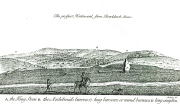
Only known drawing of Gough's Barrow

Only known drawing of Gough’s Barrow

In days of olde there were heathen sites around the edges of the beautiful Rollright Stones complex that have sadly fallen prey to the intensive agriculture of more modern ‘civilized’ times.  It’s become the way of things….. One site of importance in this geomythic  pantheon was the ‘Gough’s Barrow’—so named after a drawing was done of the site by Richard Gough, editor of the 1789 edition of Camden’s Britannia.  As far as I’m aware, it is the only one ever done of this monument.  The Oxford archaeologist George Lambrick (1988) saw “every reason to accept the position and details of the barrow”, upon which stood at least two large stones—one of which gained the description of a ‘druidical pillar.’

Stukeley's 1743 drawing

Stukeley’s 1743 drawing

The same barrow may have been recorded in one of drawings of the great William Stukeley, who visited the Rollright Stones in 1710 and then again in 1723.  On the left-side of the adjacent drawing you can see a denuded mound close to the edge of the picture, similar in shape and form to that drawn by Richard Gough.  It is probably the same tumulus or barrow.  Trial excavations at the site in 1983 looked for any remains of the old tomb, but nothing significant was uncovered.  Lambrick estimated that the site probably measured “about 18m wide and 20m long east-west,” and “was a megalithic barrow and was therefore probably Neolithic in origin.” 

References:

  1. Bennett, Paul & Chanter, James, The Complete Rollright Stones, forthcoming
  2. Bennett, Paul & Wilson, Tom, The Old Stones of Rollright and District, Cockley Press: Chipping Norton 1999.
  3. Burl, Aubrey, Great Stone Circles, Yale University Press 1999.
  4. Lambrick, George, The Rollright Stones, English Heritage 1988.
  5. Peters, Frances, “An Antiquarian Visit to the Rollright Stones,” in Wiltshire Archaeological & Natural History Magazine, volume 94, 2001.
  6. Stukeley, Willliam, Abury – A Temple to the British Druids, London 1743.

© Paul Bennett, The Northern Antiquarian


Barrow Hill Stone, Chastleton, Oxfordshire

Standing Stone (destroyed):  OS Grid Reference – SP 257 282

Archaeology & History

We have found only one reference to this lost standing stone that could once be seen adjacent to the very well-preserved Chastleton Barrow Camp to the east of the village. In her scarce little work on the history of Chastleton House, Margaret Dickins (1900) told that,

“the oldest thing to be seen at Chastleton is the prehistoric stone, which till lately served as a field gate post on the Barrow Hill.”

This monolith was one in a series of megalithic sites in and around the village that have been destroyed due to the actions of ill-informed land-owners. In this case, the standing stone was in close association with the subsequent Iron Age encampment (this missing stone should not be confused with the nearby Goose Stones, greatly damaged).

References:

  1. Bennett, P. & Chanter, James, The Complete Rollright Stones, forthcoming
  2. Dickins, Margaret, Chastleton House, Walker: Stratford 1900.

© Paul Bennett, The Northern Antiquarian


Strand Cross, Westminster, London, Middlesex

Cross (destroyed):  OS Grid Reference – TQ 3077 8093

Also Known as

  1. Stone Cross of the Strand

Archaeology & History

First mentioned in Latin manuscripts from 1274 CE, the best description of this long lost monument, curiously, appears to be in Gover’s Place Names tome.  In a slightly edited format he told us the following:

“There was a stone cross “without the bar of the New Temple” traditionally supposed to have been erected by William Rufus “in devotion to the Holy Cross and for the health of the souls of himself and his mother, Queen Maud… It was in the Strand, possibly on the site of the present church of St. Mary.  It is referred to as crucem lap’ in 1274; la Crois de Piere in 1293; …Stonecrouch in 1337; crucem fractum in 1342…”

In subsequent notes Gover et al (1942) tell of a man they found in historical records to be Thomas le Barber, “described alternatively  as being Thomas le Barber atte Stonecourche” in the Calendar of Rolls records of 1337, and again in the 1339 accounts.

Of the cross itself, information is minimal and scattered.  It was destroyed several centuries ago but is mentioned in a number of old books on the history of the city.  The historian Thomas Allen (1829), for example, told that

“opposite to Chester Inn stood an ancient cross.  On this cross in the year 1294, the judges sat to administer justice, without the City.”

It was also a site where legal pleas for the county of Middlesex were to be held, at “the Stone Cross of lad Straund” as it was then known.  Due to the early administrative function delivered from this cross, it strongly implies the place to have been a moot site prior to the erection of the cross, probably dating from the period in which tribal elders met here.

A Mr Newton tells in his London in the Olden Time that the top of the cross was damaged and knocked off by the crazy christians around the time of the Reformation and that for many years stood headless.  When Vallance (1920) came to describe it, he told merely that,

“the Strand Cross, near Covent Garden.  This cross was hexagonal on plan, and comprised four stages.  It was standing in 1547, but was ultimately removed, its site being occupied by the Maypole, which was spoken of in 1700 as new.”

The Strand Cross would have been on the ancient ley (not one of those ‘energy lines’ invented by New Age fantasists) described first of all by Alfred Watkins (1925)—running from St. Martins-in-the-Field to St. Dunstan’s in Fleet Street—but he seems to have been unaware that the monolith ever existed.  The alignment was subsequently described in more detail in Devereux & Thomson’s (1979) work on the same subject, but its existence seems to have evaded them too!  Chris Street (2010) did include it in his much more detailed walk down the same ley.   A maypole was also known to exist close to the site of the cross; with one account showing that the two monuments existed at the same time in 1543.

As the site seemed to have been an early moot spot, the Strand Cross may have been an omphalos in early popular culture (before the christians of course), or at the very least, a site of popular animistic tradition.

References:

  1. Allen, Thomas, The History and Antiquities of London – volume 4, Cowie & Strange: London 1829.
  2. Anon., Rotuli Hundredorum – 2 volumes, G. Eyre and A. Strahan: London 1812.
  3. Aungier, George James, Croniques de London, Camden Society: London 1854.
  4. Devereux, Paul & Thomson, Ian, The Ley Hunter’s Companion, Thames & Hudson: London 1979.
  5. Gover, J.E.B., Mawer, Allen & Stenton, F.M., The Place-Names of Middlesex, Cambridge University Press 1942.
  6. Newton, William, London in the Olden Time, Bell & Daldy: London 1855.
  7. Stevenson, W.H. (ed.), Calendar of the Close Rolls Preserved in the Public Record Office, HMSO: London 1900.
  8. Street, Christopher E., London’s Ley Lines, Earthstars: London 2010.
  9. Vallance, Aymer, Old Crosses and Lychgates, Batsford: London 1920.
  10. Watkins, Alfred, The Old Straight Track, Methuen: London 1925.

© Paul Bennett, The Northern Antiquarian


Cow Cross, Finsbury, London, Middlesex

Cross (destroyed):  OS Grid Reference – TQ 3180 8181

Archaeology & History

Site of Cow Cross on 1896 map

Site of Cow Cross on 1896 map

Not far from the long lost Fag Well could once be seen this old stone monument.  Although not illustrated on the first Ordnance Survey maps of the inner city, it is highlighted on the 1896 edition (as shown here), just where Cow Cross Street meets Charterhouse Street—right by the boundary line—and is marked as ‘Site of Cow Cross’.

The cross gained its named from the cattle market that was held here from very early times, on the boundary of the lands of the Knights Hospitallers in the 12th century.  Cattle itself–both horses and cows—were actually slaughtered at the market by the cross: a practice that has thankfully stopped (in public at least).  Despite the place-name being referenced in many early accounts, actual descriptions of the cross are few and far between due to it being destroyed at quite an early date.  When John Stow came to write his history of London in 1603, he told that it was no longer standing.  Whether the cross replaced an earlier standing stone, we simply do not know…

References:

  1. Gover, J.E.B., Mawer, Allen & Stenton, F.M., The Place-Names of Middlesex, Cambridge University Press 1942.
  2. Temple, Phillip (ed.), Survey of London – volume 46, LCC: London 2008.
  3. Vallance, Aymer, Old Crosses and Lychgates, Batsford: London 1920.

© Paul Bennett, The Northern Antiquarian


Power Station Road, Sheerness, Isle of Sheppey, Kent

Settlement (destroyed):  OS Grid Reference – TQ 932 733

Archaeology & History

An extensive site that was uncovered when a housing estate was being built on the south-side of Power Station Road at the end of the 20th century.  During the Spring and Summer of 1998, the Canterbury Archaeological Trust began cutting trenches across the land and did some minor excavation work on the west side of the area, finding some traces of early human activity.

A second series of investigations was then undertaken by the Hertfordshire Archaeological Trust  over the Autumn and Winter months of 1998-99, with the Kent Archaeological Rescue Unit then taking over for the rest of the year.  Their team split the land into eight large sections and began a more detailed analysis and uncovered a huge number of finds.  Amidst this, wrote Brian Philp (2002), there

“included an important collection of Bronze Age material, including large clay-weights, perforated baked-clay slabs and a good range of pottery types.  Of special interest was the spinal bone of a large whale, perhaps washed up on the nearby shore.

“The picture now emerging is that of a substantial Bronze Age settlement site, spread across several acres and probably farming the adjacent land… It seems likely that three large ponds and…eight stone-lined pits were primarily for water-storage, both for watering cattle and for other agricultural or semi-industrial purposes… All this seemed to be happening about 900-400 BC on what still appears to be the largest Bronze Age settlement so far discovered on this important island.”

The archaeocentric place-name of Barrows Hill rises a mile to the southwest.

References:

  1. Philp, Brian, Archaeology in the Front Line, KARU: Dover 2002.
  2. Schuster, Jorn, “The Neolithic to Post-Medieval Archaeology of Kingsborough, Eastchurch, Isle of Sheppey: From Monuments to Fields,” in Archaeologia Cantiana, volume 130, 2010.

Links:

  1. Kent Archaeological Review

© Paul BennettThe Northern Antiquarian 2016


Dumpton Park, Ramsgate, Kent

Tumulus (destroyed):  OS Grid Reference – TR 389 661

Archaeology & History

A little-known site which archaeologist Brian Philp (2002) called “a Bronze Age barrow”.  When the old Greyhound Stadium at Ramsgate was being demolished for a new housing estate, planning conditions required an archaeological evaluation and so Philps and his team set out to explore the area in February 2000.  They weren’t to be disappointed!  Unearthing a ring ditch nearly 20 yards (18m) across, they found that it had been cut into the local chalk some three feet deep.  Although there was no obvious entrance, the northeast section of the ancient monument,

“was found to be covered by a compact layer of flint metalling.  This was a wide and well-made surface or platform, perhaps of Iron Age date, which clearly covered the silted ring-ditch,  Nearby was a large male skeleton in a very shallow grave and with head missing due to later disturbances.”

The excavated ring ditch (after Philp 2002)

The excavated ring ditch (after Philp 2002)

The crouched skeleton (after Philp 2002)

The crouched skeleton (after Philp 2002)

But the best was yet to come!  In another section of the circular monument, cut into the chalk itself, they found a complete male skeleton laid in typical foetus position, on its left side, with a large beaker pot positioned in front of it.  These beakers are pretty common and tend to be seen as once holding food enabling the dead to eat in their journey into the Land of the Dead.  It makes sense.  The entire monument has since been completely destroyed.

References:

  1. Philp, Brian, Archaeology in the Front Line, KARU: Dover 2002.

Links:

  1. Kent Archaeological Review

© Paul BennettThe Northern Antiquarian 2016


Hickford Hill, Belchamp St Paul, Essex

Enclosure:  OS Grid Reference – TL 7872 4537

Archaeology & History

Ground-plan of enclosure & surrounding barrows

Plan of enclosure & surrounding barrows

Several hundred yards northeast from Hickford Hill, a cluster of prehistoric sites could once be seen close to each other just south of the River Stour below line of the Essex-Suffolk county boundary.  Several of these were tombs and are accounted for in Priddy’s (1981) essay on the prehistoric Barrows of Essex; but adjacent to them were also found faint traces of a large circular enclosure of some sort, which Harding & Lee (1987) included in their definitive survey of British henge monuments. Their account of it was brief and simple, saying:

“Enclosure defined by the cropmark of a sub-circular rather narrow ditch broken by two entrances.  No trace of a bank.  Internal traces of a concentric innner ditch in part of the circuit… Internal diameter range 56-57m…; width of outer ditch c.1.5-2.5m; width of entrances, c.7m (E) and 16m (NW); width of inner ditch c.2.5-5m.”

Although this large ringed enclosure was thought by the Haverhill & District Archaeology Group to “be a henge-type monument,” Harding & Lee (1987) thought it unlikely that these remains “belong to the henge class” of monuments.  A brief archaeological dig into one of the trenches here in 1997 showed the site to be Bronze Age; but finds by the local archaeology team have also come across finds in the fields hereby dating from the Mesolithic and Neolithic periods.

References:

  1. Harding, A.F. & Lee, G.E., Henge Monuments and Related Sites of Great Britain, BAR 175: Oxford 1987.
  2. Priddy, D., “The Barrows of Essex,” in A.J. Lawson’s The Barrows of East Anglia, Norfolk Museums Service 1981.

© Paul Bennett, The Northern Antiquarian


Boxted Cross Henge, Colchester, Essex

Henge Monument:  OS Grid Reference – TM 0093 3277

Archaeology & History

Boxted Henge plan (Colchester Archaeology Group)

Boxted Henge plan (Colchester Archaeology Group)

As with many sites in Southern England, intensive agriculture has taken its toll on the archaic monuments.  The Boxted Cross henge is no exception and hardly any elements of it remains today.  But it seems that it was an impressive fella in our more ancient heathen past.

The site was only rediscovered in the 1970s and was first described in Mrs Ida McMaster’s (1975) survey of crop-marks that had been revealed by aerial surveying in Essex and Suffolk counties.  Her brief account of the monument told it to be,

“A Class II henge with a wide somewhat ploughed out ditch. Various linear ditches are near, together with prolific variegated ‘field outlines’ of glacial subsoil cracking which extends into the next field southwards. The ditch terminals of the southwest entrance to the henge appear to be wider than the general run of the ditch, say 4-5 metres.”

When Harding & Lee (1987) examined the site, they were a little more cautious in their interpretation of it being a definite henge, citing that there was “insufficient information, but cannot be ruled out as henge-related,” adding that it “could also be a mill.”  This latter element seems unlikely, though a windmill may have been built onto the site at a later date.

More recently however the site has been categorized by Historic England as “a Late Neolithic henge.”  The monument itself was defined by a broad circular ditch with two large opposing entrances to the north and south.  The total diameter of the enclosure is 44 yards (40m) across; but with the surrounding ditch measuring 5½ yards (5m) across all around, the inner level of the henge was about 33 yards (30m) in diameter.  Plenty of room for partying old-style!

References:

  1. Harding, A.F. & Lee, G.E., Henge Monuments and Related Sites of Great Britain, BAR 175: Oxford 1987.
  2. McMaster, Ida, “Crop Marks Selected and Plotted,” in Colchester Archaeological Group Bulletin, volume 18, 1975.

© Paul Bennett, The Northern Antiquarian