Auchentorlie, Old Kilpatrick, Dumbartonshire

Cup-and-Ring Stones (lost):  OS Grid Reference – NS 444 747

Archaeology & History

A couple of interesting multiple-ringed carvings were found high up on the slopes above Bowling, not far from the Bow Linn waterfalls, near the end of the 19th century.  John Bruce (1893) told that, shortly after the discovery of the Cochno carvings,

“in the year 1889, two cup and ring marked stones were discovered in a dyke near the old farmhouse of Auchentorlie while the reservoir for the district water supply was being excavated close by.”

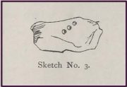
But since then, they seem to have disappeared.  Searches for them by the old petroglyph writer Ron Morris in the 1960s and the Royal Commission lads in the 1970s both drew a blank.  If we’re lucky, they might be hiding in a box somewhere, in the storage rooms of Glasgow’s Kelvingrove Museum.  As you can from the sketches done by W.A. Donnelly, they’re quite impressive.  The drawings give the impression that they were small portable carvings, which may suggest they were once part of a prehistoric cist or cairn, although no such site has been found in this locale.  If this isn’t the case, their small size is an oddity.

References:

  1. Bruce, John, The History of the Parish of West or Old Kilpatrick,  John Smith: Glasgow 1893.
  2. Morris, Ronald W.B. & Bailey, Douglas C., “The Cup-and-Ring Marks and Similar Sculptures of Southwestern Scotland: A Survey,” in Proceedings of the Society of Antiquaries, Scotland, volume 98, 1966.
  3. Royal Commission Ancient Historical Monuments, Scotland, The Archaeological Sites and Monuments of Dumbarton District…, HMSO: Edinburgh 1978.

© Paul BennettThe Northern Antiquarian

Dumbuck Hill, Milton, Dumbarton, Dumbartonshire

Cup-Marked Stone (lost):  OS Grid Reference – NS 419 747

Archaeology & History

Very little is known of this site.  It was discovered in the 1890s by a Mr W.A. Donnelly who was responsible for some of the early drawings of the famous Cochno Stone carving (found a few miles east of here), but it seems that he made no such sketch of this particular carving—although it doesn’t sound too impressive when we compare it to some of the others in this area.  It was thankfully mentioned, albeit briefly by John Bruce (1893), who told that it was “a boulder with a large basin and a duct heading therefrom…at the foot of Dumbuck Hill.”  The carving may well have been destroyed by quarrying.

References:

  1. Bruce, John, The History of the Parish of West or Old Kilpatrick,  John Smith: Glasgow 1893.
  2. Morris, Ronald W.B. & Bailey, Douglas C., “The Cup-and-Ring Marks and Similar Sculptures of Southwestern Scotland: A Survey,” in Proceedings of the Society of Antiquaries, Scotland, volume 98, 1966.
  3. Royal Commission Ancient Historical Monuments, Scotland, The Archaeological Sites and Monuments of Dumbarton District…, HMSO: Edinburgh 1978.

© Paul BennettThe Northern Antiquarian

Dunarbuck, Old Kilpatrick, Dumbartonshire

Cup-Marked Stone (lost):  OS Grid Reference – NS 449 740

Also Known as:

  1. Dunerbuck
  2. Greenland (5)

Archaeology & History

Bruce’s 1893 sketch

This small and visually trivial cup-marked stone is one of a number in this neck o’ the woods that have either been destroyed or simply lost.  This stone has the “lost” label stamped on it!  It was first described in John Bruce’s (1893) classic local history work where he told it to be “a boulder of sandstone with three cup-marks…(that) lies on the slope of the Hill of Dun, about 100 yards north of Dunerbuck  farmhouse.”  It doesn’t appear to have been seen since, as none of the classic petroglyph writers described seeing it and a search for it in Glasgow’s Kelvingrove Museum in the 1960s drew a blank.  The carving has subsequently been added to archaeological inventories with the standard, “this cup-marked boulder cannot now be located.”  It may yet be found, overgrown by grasses and mosses, just that hundred yards or so above the buildings behind Dunarbuck.  That entire area needs scanning to be honest…

References:

  1. Bruce, John, The History of the Parish of West or Old Kilpatrick,  John Smith: Glasgow 1893.
  2. Bruce, John, “Notice of Remarkable Groups of Archaic Sculpturings in Dumbartonshire and Stirlingshire,” in Proceedings of the Society of Antiquaries of Scotland, volume 301896.
  3. Royal Commission Ancient Historic Monuments, Scotland, The Archaeological Sites and Monuments of Dumbarton District…, HMSO: Edinburgh 1978.

© Paul BennettThe Northern Antiquarian

St. Patrick’s Well, Old Kilpatrick, Dumbartonshire

Holy Well (destroyed):  OS Grid Reference – NS 4631 7307

Also Known as:

  1. Trees’ Well

Archaeology & History

Photo of the Well in 1893

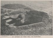
Sadly there are no longer any remains of this holy well which was found, “beside the church dedicated to St Patrick — which was said to be built on soil brought from Ireland in honor of its patron,” wrote John Bruce in 1893.  He told that its waters had “been used until lately from time immemorial by the villagers, but now has been found unfit for use and consequently ordered to be closed up.”  Although its waters were used for baptisms, he made no mention of any medicinal repute, which it surely would have possessed.

Site of well on 1939 map

The original position of the well, according to Mr Bruce, was “adjoining the church” but, according to the Ordnance Survey lads, when they came here in 1963 they located a drinking fountain on the other side of the road about 80 yards to the west and designated that as being St Patrick’s Well.  The place had earlier been given a wooden sign saying “St Partrick’s Well.”  Local tradition attributes St. Patrick as originally coming from this village, whose saint’s day is March 17.

The place was also known as Trees’ Well, suggestive, perhaps, of a local person, although I can find no reference as to who or what that might have been.

References:

  1. Bruce, John, The History of the Parish of West or Old Kilpatrick,  John Smith: Glasgow 1893.

Acknowledgements:  Huge thanks for use of the Ordnance Survey map in this site profile, reproduced with the kind permission of the National Library of Scotland

© Paul BennettThe Northern Antiquarian

Craigenkirn, New Kilpatrick, Dumbartonshire

Long Cairn:  OS Grid Reference – NS 51839 78157  —  NEW FIND

Getting Here
Aerial view of the cairn

Aerial view of the cairn

Take the A809 road several miles north out of Glasgow, between Bearsden and Drymen.  Once out of the suburban sprawl, passing Milngavie, you’re heading to the famous Carbeth hutters.  Before this, note the gold course on your right (east).  Park here and cross the road where a gate and overgrown footpath takes you onto the grassy hills.  Keep to the fence-side for about 700 yards until it veers downhill.  Don’t walk downhill!  Keep in the same direction into the short grasses and, veering gradually left, downhill for a couple hundred yards ahead and, across a small boggy area, you’ll note some large upright stones in front of a mound.  That’s it!

Archaeology & History
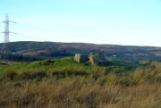
The SE stone 'entrance'

The SE stone ‘entrance’

There is no previous reference to this site which was found, quite fortuitously, by Nina Harris of Organic Scotland a few years ago.  She visited the site a number of times, puzzling over the curious line of possible standing stones at the edge the grass-covered mound—wondering if it was anything at all.  A few months ago she took us to see the place…
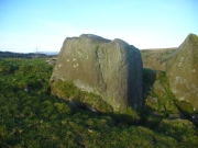
Modern gunshot cup-marks on entrance stone

Modern gunshot cup-marks on entrance stone

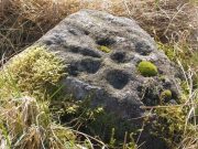
The site has been damaged and elements of it have been stripped for walling that are visible all around here.  The cairn is more than 55 yards in length, running from its southeastern stone ‘entrance’ to the gradually diminishing northwestern edges.  At its widest it is 14.6 yards (13.5m) across, near its southeastern end.  The main three standing stones at its entrance are four-feet tall at the highest, with one of them leaning upon another; an adjacent fourth stone, smaller than the main three, is more embedded into the cairn mass a couple of yards away.  Cup-marks on one of the three larger uprights here are recent gunshot marks; whilst the possible cup-marks on the largest upright are natural.
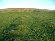
Line of ealling runs to the cairn

Line of ancient wall runs up and over the cairn
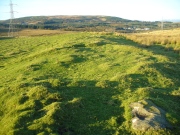
Looking NW along the cairn mass

Looking NW along the cairn mass

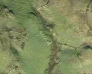
In standing on top of the long cairn, just above the large stones, you can see how sections of it have been stripped away.  Just beneath the surface is a line of internal walling, with what seems to be another one running parallel.  These run for a few yards until we reach a large circular depression within the overall cairn mass, a yard deep and 6-7 yards across; on the northern edge of which we can clearly see a section of walling beneath the surface.  When we look at the aerial view of this on Google Earth, we can clearly see how this walling actually begins way outside of the cairn mass itself, as a much denuded line of it (probably medieval in origin, though possibly Iron Age) curves across the grasslands from the west, crosses the long cairn and re-emerges on the other side of the adjacent boggy ground at its southeastern edges and continues on its way: indicating that the cairn mass beneath the wall is much older than the walls running across it.
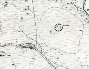
"X" marks the spot!

“X” marks the spot!

The main three 'entrance' stones

The main three ‘entrance’ stones

Audrey Henshall (1972) described the existence of another prehistoric chambered tomb like this one at Cairnhowit 1.95 miles (3.14km) southwest, and we find the Stockie Muir long cairn 3.12 miles (5.02km) to the northwest, clearly showing that the incidence of this monument is not an isolated one.  Others can be found not much further away.  The existence of the raised geological plate known as Carneddans Wood just over a mile south may have once been home to another chambered cairn.

Please note that the grid reference for this site fixes on the southeastern section of the cairn, where the upright stones are.

References:

  1. Henshall, Audrey S., The Chambered Tombs of Scotland – volume 2, Edinburgh University Press 1972.

Acknowledgements:  First and foremost to Nina Harris, for unknowingly finding the place; also to Paul Hornby and Marion Woolley for visits to the site.

© Paul BennettThe Northern Antiquarian