Culliford Tree Barrow, Upwey, Dorset

Tumulus:  OS Grid Reference – SY 6691 8548

Also Known as:

  1. Music Barrow
  2. Warne’s Barrow 22
  3. Whitcombe 1 (Grinsell)

Archaeology & History

Crowned by a clump of trees (planted in 1740), this hilltop site is one of the more impressive of a number of tombs hereby, with its nearest other neighbour being 70 yards southeast of here.  One of Dorset’s early tribal meeting places (Anderson 1934), the tomb was illustrated on Isaac Taylor’s 1765 map of the region and was dug into in 1858 “on the orders of a local magnate” (Marsden 1999), damaging some substantial portion of the tomb.  Of this, craniologist and antiquarian John Thurnam was most displeased; for in his description of the opening of Culliford Tree he wrote:

“A wide trench had been dug through it one side, from the summit and the rubble which had been thrown out had not been replaced… Another subject of regret was the fact that though, as we were told by the neighbouring rustics, human remains, with pottery and certain other relics, were found in the barrow, no authentic account of the exploration had, so far as we could learn, been put to print.”

Leslie Grinsell (1959) found the same trouble in his assessment of this site; and the Royal Commission (1970) lads could only describe the site thus:

“Large trench on south and top almost certainly dug in 1858 when four secondary extended inhumations, one with necklace of amber and two gold-plated beads, and cremation with incense cup in collared urn, were found.”

However, it seems that the necklace and gold-plated beads have been “lost” — i.e., someone has them in their own private collection somewhere!

Folklore

This is one of very few tombs in this part of the country where we find the tradition of fairy music.  Grinsell (1959) told that:

“The Culliford Tree barrow, formerly the meeting place of the Hundred of Culllingford Tree, is also known as the Music Barrow from the belief that music could be heard beneath the mound by those who listened at the apex at midday.”

References:

  1. Anderson, O.S., The English Hundred-Names, Lunds Universitets Arsskrift 1934.
  2. Grinsell, Leslie V., Dorset Barrows, Dorset Natural History & Archaeological Society: Dorchester 1959.
  3. Marsden, Barry M., The Early Barrow Diggers, Tempus: Stroud 1999.
  4. Royal Commission on Historical Monuments, An Inventory of Historical Monuments in the County of Dorset – Volume 2: South-East, Part 3, HMSO: London 1970.
  5. Warne, Charles, Celtic Tumuli of Dorset: An Account of Personal and other Researches in the Sepulchral Mounds of the Durotriges, Smith: London 1866.

© Paul Bennett, The Northern Antiquarian

Long Bredy Cursus, Dorset

Cursus:  OS Grid Reference – SY 5718 9115

Also Known as:

  1. Martin’s Down Cursus

Archaeology & History

Although very little of this cursus can be discerned on the ground, the scar of the monument is clearly visible from the air (as the GoogleEarth image shows, below).  In 1989 the great archaeo-geomancer, Paul Devereux, visited the place hoping to see the monument, but said that no remains were visible at ground level, although noted how its western end is marked by the Long Bredy burial mound.  Sitting amidst a mass of later neolithic and Bronze Age ceremonial remains, this old cursus aligned SE to NW.  Devereux told how,

“the extended axis of the cursus…to the east, goes through a group of round barrows on the crest of a ridge on Black Down about a mile away. If diagrammatic material published by an investigating archaeologist is accurate, the alignment continues to the Nine Stones circle…immediately by the roadside a short distance west of Winterbourne Abbas.”

The monument has been measured at be at least 130 yards (100m) long and 28 yards in diameter at its greatest point.

References:

  1. Pennick, Nigel & Devereux, Paul, Lines on the Landscape, Robert Hale: London 1989.

© Paul Bennett, The Northern Antiquarian

Litton Cheney, Dorset

Timber Circle / Earthworks:  OS Grid Reference – SY 556 917

Getting Here

From Litton Cheney go north up the White Way road until it meets the main A35 crossroad.  Go across the road, then get over the fence on your right and onto the rise in the hill.  These earthworks, or timber circle remains, are under your feet!

Archaeology & History

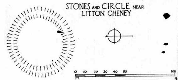
Lay-out of site by O.G.S. Crawford, 1939

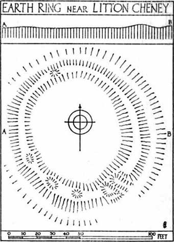
Shown on modern OS-maps as an ‘earthwork’, but ascribed elsewhere as a timber circle, when Stuart & C.M. Piggott visited and surveyed this site in the 1930s, they thought it to be the remains of stone circle.  Found on a prominent rise in the landscape with excellent views all round here, the Piggott’s description of the site told:

“It consists of a shallow ditch with internal bank, enclosing a somewhat oval area measuring 75 feet from north to south, and 63 feet from east to west. The ditch, which lies on the southeast, where the ground has been disturbed, does not reach a depth of more than about one foot, while the bank rises nowhere above 2.5 feet. It is possible there was an entrance on the southeast, but the bank is disturbed at this point. On the crest of the bank on the southwest are 3 almost circular depressions, some 6 feet in diameter, and placed 20 feet distant from one another along the circumference of the bank. Another similar depression is on the northeast, while yet another may have existed in the disturbed portion of the bank on the southeast.”

It was these finds which led them to suppose a ring of stones originally surmounted this small hillock, twelve in all.

Lay-out of the circular remains, by O.G.S. Crawford
Ground-plan by O.G.S. Crawford

Another site — which they called ‘Litton Cheney 2’ — was found less than 50 yards to the east of here by a Mr W.E.V. Young and the Piggotts.  These remains comprised of, “a very shallow and regular ditch surrounding a circular area 47 feet in diameter.  A single sarsen lies on the inner lip of the ditch on the southeast” which, they thought, may have been the solitary remains of yet another stone circle. Three other sarsen stones were found 90 feet south of here, but they were unsure whether they related to the circle or not.

Archaeological remains from here dated from 2200-1400 BC and local researcher Peter Knight (1996) thought that the sites ascribed here as megalithic rings to be correct.  He also found that tumuli visible some 5 or 6 miles southeast of here, on top of Black Down Hill (where the Hardy Monument’s found), “marks out the winter solstice sunrise.”  A dip in the horizon to the northwest, he claims, also marks the summer solstice sunset from here.  Knight also mentions how “both Litton Cheney sites lie close to a ley line going to the Nine Stone Circle and beyond.”

References:

  1. Knight, Peter, Ancient Stones of Dorset, Power: Ferndown 1996.
  2. Piggott, Stuart & C.M., ‘Stone and Earth Circles in Dorset,’ in Antiquity, June 1939.

© Paul Bennett, The Northern Antiquarian