Winterborne Came 18b, Bincombe, Dorset

Tumulus (destroyed):  OS Grid Reference SY 6800 8600

Also Known as:

  1. Monument No.1300126  (Pastscape)

Archaeology & History
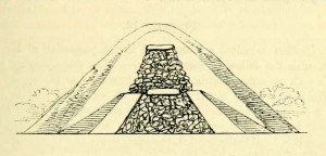
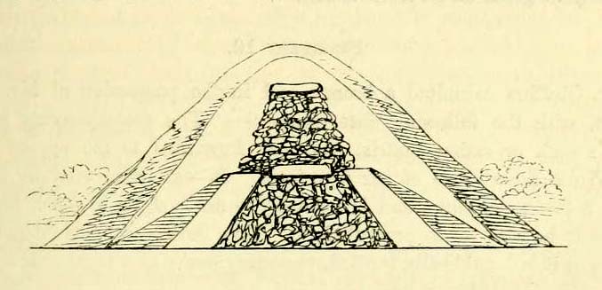
Charles Warne's 1848 drawing of the old tumulus
Charles Warne’s 1848 drawing of the old tumulus

A number of very large prehistoric burial mounds, or tumuli, were destroyed in this part of Dorset in the 19th century, including “three on the Came estate, near Dorchester, the property of the Hon Col. Damer.” This one—listed as a “bowl barrow” and known today as the Winterborne Came 18b tumulus in Grinsell’s (1959:148) brilliant survey—was found to house examples of petroglyphs, which are very rare in this part of Britain.  Thankfully before its destruction, the local antiquarian Charles Warne (1848) was present and has left us with a good description of its structure and contents.  After first telling of the demise of two other large tumuli close by, the biggest of them drew his attention:

“The last of these mighty mounds (and well do they merit the appellation from their vastness), measured rather more than ninety feet in diameter, and sixteen feet in height; this from the peculiarity of its contents was the most interesting of the three. The annexed rough sketch (above), shewing a central section of the tumulus, may serve to give some idea of the singularity of its composition. About the centre, at a depth of some three feet from the surface, was found lying flat a rough unhewn stone, with a series of concentric circles incised; this, on being removed, was seen to have covered a mass of flints from six to seven feet in thickness, which being also removed we came to another unhewn irregular stone, with similar circles inscribed, and as in the preceding case, covering another cairn of flints, in quantity about the same as beneath the first stone. It was in this lower mass that the deposits were found, consisting of all the fragments of an urn of coarse fabric, and apparently as if placed in its situation without either care or attention, no arrangement of the flints being made (as we have elsewhere seen) for its protection; the want of which observance had completed its destruction.  Under the flints, lying at the base, were the remains of six skeletons, and some few bones of the ox. The skeletons had apparently been placed without order or regularity: with the exception of a few bits of charcoal with the urn, there was no evidence of cremation.”

Nearly twenty years later, Sir James Simpson (1867) also described the tumulus and its carved rocks in his 19th century magnum opus, repeating much of Warne’s earlier description, saying:

“In his antiquarian researches in this county (Dorset), Mr Warne opened , at Came Down on the Ridgeway, a tumulus of rather unusual form. At its base…were found the remains of six unburnt human skeletons…and some few bones of the ox.  Above them, and in the centre of the tumulus, was built up a cairn or heap of flints around a coarse and broken urn, which contained calcined bones.  This mass of flints was surrounded and covered by a horizontal rough slab.  Above and upon this slab was built another large heap of flints, six or seven feet in thickness.  This second heap was capped with another rough slab, lying two or three feet below the surface of the tumulus.  Both these flat unhewn covering slabs had a group of concentric circles cut upon them.”

We don’t know for sure the exact whereabouts of the tumulus, nor the age of the tomb and its remains.  But the size of it may indicate an early Bronze Age and perhaps even neolithic status. The finding of the rock art in the tomb is also an indicator that could push the date back into late neolithic period—but we may never know for sure…

References:

  1. Grinsell, Leslie V., Dorset Barrows, Dorset Natural History & Archaeological Society 1959.
  2. Royal Commission on Historical Monuments (England), An Inventory of Historical Monuments in the County of Dorset – Volume 2: South-East, HMSO: London 1970.
  3. Simpson, James, Archaic Sculpturings of Cups, Circles, etc., Upon Stones and Rocks in Scotland, England and other Countries, Edmonston & Douglas: Edinburgh 1867.
  4. Warne, Charles, “Removal of Three of the Large Tumuli on the Came Estate, near Dorchester,” in Journal of the British Archaeological Association, volume 3, 1848.
  5. Warne, Charles, The Celtic tumuli of Dorset: An Account of Personal and other Researches in the Sepulchral Mounds of the Durotriges, J.R. Smith: London 1866

© Paul Bennett, The Northern Antiquarian 


Came Down Carving, Winterborne Came, Bincombe, Dorset

Cup-and-Ring Stone:  OS Grid Reference – SY 6800 8601

Also Known as:

  1.  Winterborne Came 18b Carving (Grinsell)

Archaeology & History

Charles Warne's 1848 drawing of the old tumulus
Charles Warne’s 1848 drawing of the old tumulus

On January 27, 1848, the great Dorsetshire antiquarian Charles Warne sent a letter to the British Archaeological Association about a series of three large tumuli he’d explored south of Dorchester in Dorset, within which he’d found some fascinating remains. And in what he called “the last of these mighty mounds (and well do they merit the appellation from their vastness),” which “measured rather more than ninety feet in diameter, and sixteen feet in height,” the most intriguing remains emerged. In the middle of what L.V. Grinsell (1959) catalogued as the Winterborne Came 18b tumulus, Mr Warne told:

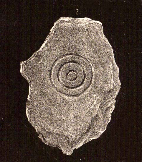
“About the centre, at a depth of some three feet from the surface, was found lying flat a rough unhewn stone, with a series of concentric circles incised; this, on being removed, was seen to have covered a mass of flints from six to seven feet in thickness, which being also removed we came to another unhewn irregular stone, with similar circles inscribed, and as in the preceding case, covering another cairn of flints, in quantity about the same as beneath the first stone.”

“…It will be seen that the most singular feature connected with this tumulus, is that of the incised stones: examples of which I am not aware have before been met with in like situations. It may be as well to forego any attempt at an elucidation, which must be purely hypothetical; but it seems more reasonable to believe that they bore some mystic reference, rather than that they were the unmeaning amusement of some Celtic idler.”

One of 2 carved stones found in the tumulus

Sir James Simpson (1867) described these carved stones in his 19th century magnum opus, giving an early illustration of one of them, as shown here.  You’ll note that the carving is devoid of any central ‘cup’ as commonly found, consisting simply of a mere series of concentric rings.

If anyone knows the whereabouts of this and its companion stone today, it would be good to see them.  Are they kept in some local museum?

References:

  1. Grinsell, Leslie V., Dorset Barrows, Dorset Natural History & Archaeological Society 1959.
  2. Royal Commission on Historical Monuments (England), An Inventory of Historical Monuments in the County of Dorset – Volume 2: South-East, HMSO: London 1970.
  3. Simpson, James, Archaic Sculpturings of Cups, Circles, etc., Upon Stones and Rocks in Scotland, England and other Countries, Edmonston & Douglas: Edinburgh 1867.
  4. Warne, Charles, “Removal of Three of the Large Tumuli on the Came Estate, near Dorchester,” in Journal of the British Archaeological Association, volume 3, 1848.

© Paul Bennett, The Northern Antiquarian


Woodhenge, Dorchester, Oxfordshire

Timber Circle (destroyed):  OS Grid Reference – SU 5775 9513

Also Known as:

  1. Dorchester 3
  2. NMR NUMBER: SU 59 NE 53
  3. Site no. 371.21.1

Archaeology & History

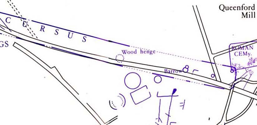
Dorchester's Woodhenge in the cursus
Dorchester’s Woodhenge in the cursus

Although ascribed as a wooden ‘henge’ by archaeologist Jean Cook, the site is more accurately a simple timber circle.  Cook (1985) described this little-known “Wood Henge” monument, as she called it, sat inside the lower southeastern end of the impressive Dorchester Cursus monument.  The site was obviously of some ritual importance, for a variety of reasons.  It was excavated in 1981 and,

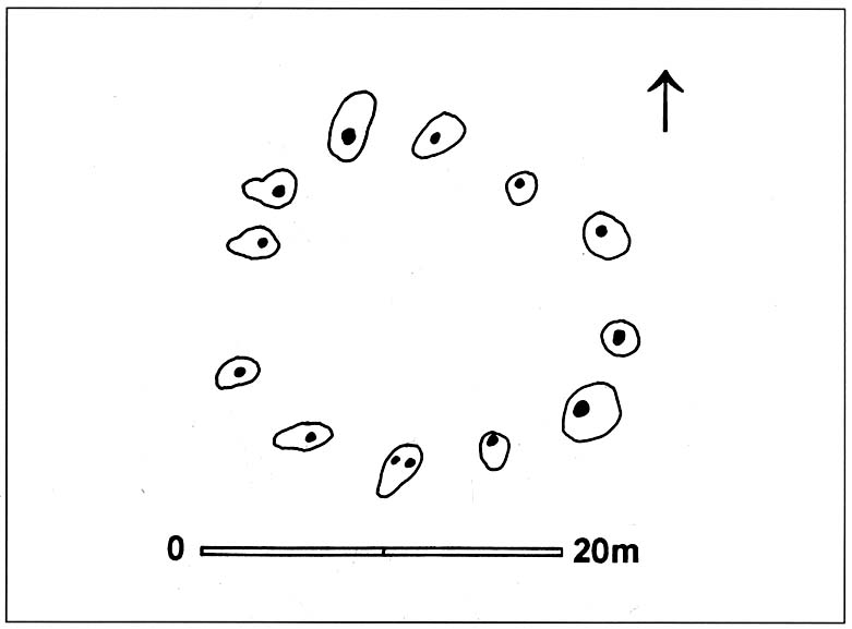
“it consisted of a ring of large pits enclosing an area some 18m in diameter.  The site was situated along the central axis of the (Dorchester) cursus, presumably influenced by the alignment.  The pits, which varied in size, had each contained a wooden post, in three instances consisting of an entire trunk of an oak tree.  All the posts were burnt in situ, presumably during some form of destruction ceremony.”

Groundplan of site

When Alex Gibson came here a few years afterwards to re-examine the site, his work and that of Richard Bradley (1988) also found the place to have been an elliptical ‘ring’ of once-upright timber posts.  Although Gibson (1998) later gave a confused version of where the site actually was (wrong grid-refs), his brief description gave us an outline of what was once here:

“An oval of 12 postholes containing the carbonized remains of 13 posts which had been burnt prior to the placing of cremations in the upper fills of the postholes.  The SW posthole contained the remains of two posts in the same socket.  There is a possible entranceway, marked by a wider gap between posts, in the NW.”

But this last line appears to be pure speculation. I’ve not read the longer archaeological accounts of this ‘wood henge’ and adjacent sites (Bradley & Chambers, 1988; Gibson 1992), which should give greater details about the site as a whole.  The Pastscape site gives the following information:

“A pit circle comprising a sub-circular arrangement of 12 pits was excavated in the early 1980s in advance of work on the Dorchester by-pass. The site lay within the Dorchester Cursus (SU 59 NE 5), circa 400 metres northwest of its southeastern terminal. The long axis of the pit circle was the same as that of the cursus. Each of the pits had held a timber upright, and some if not all had been burnt in situ. An air photograph of the site had suggested the presence of a central pit but this feature proved to be a natural pocket of sand. Six deposits of cremated bone came from various post pipes. Other finds included a handful of potsherds, one possibly of Early Bronze Age date, some animal bone fragments, and a few flints. Radiocarbon dates from cremated bone and charcoal centred on the mid 3rd millennium BC, with one slightly later.”

References:

  1. Bradley, R. & Chambers, R., “A New Study of the Cursus Complex at Dorchester-on-Thames, in Oxford Journal of Archaeology, volume 7, 1988.
  2. Cook, Jean, “The Earliest Evidence,” in Dorchester through the Ages, Oxford University 1985.
  3. Cook, Jean & Rowley, Trevor (eds.), Dorchester through the Ages, Oxford University 1985.
  4. Gibson, Alex, “Possible Timber Circles at Dorchester-on-Thames,” in Oxford Journal of Archaeology, volume 11, 1992.
  5. Gibson, Alex, Stonehenge and Timber Circles, Tempus: Stroud 1998.
  6. Pennick, Nigel & Devereux, Paul, Lines on the Landscape, Hale: London 1989.

© Paul Bennett, The Northern Antiquarian


Castle Hill, Little Wittenham, Oxfordshire

Hillfort:  OS Grid Reference – SU 5696 9244

Also Known as:

  1. Sinodun Camp
  2. Wittenham Clumps

Getting Here

Either reach this from Dorchester’s Dyke Hills by crossing the bridge over the Thames at its southwestern side and walk thru the village and up the fields to the wooded rise on your left; or simply get take the road between Brightwell-cum-Sotwell to the delightful village of Little Wittenham and, on your right-hand side, notes the unmissable clump of trees and rise in the fields on your right.  That’s the place!

Archaeology & History

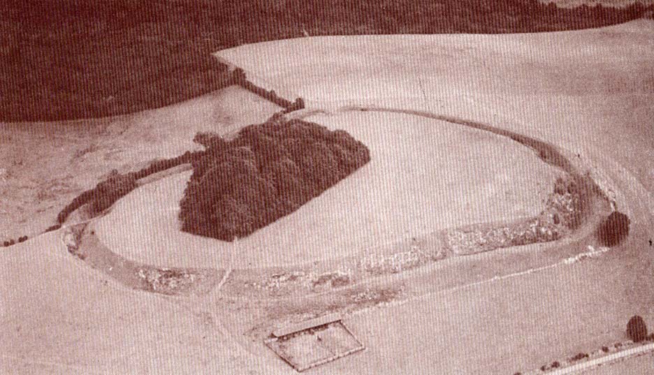
Major Allen’s 1932 photo

To be found on the southern side of the River Thames, across from the huge Dyke Hills camp, this prominent enclosed hillfort was thought to be a place where the tribal peoples of differing groups converged — the Dubonni, the Catuvellauni, and Atrebates peoples.  And to this day it remains impressive.  Long thought to have been merely the province of Iron Age settlers, in more recent years it has shown to have had a longer and richer history than academics previously dare write about.  In Jean Cook’s (1985) fine work on the archaeology of the region, she described the typical narrative Castle Hill elicited from professionals until only a few years back, saying:

“The hillfort on Wittenham Clumps covers approximately 4 hectares (c. 10 acres) and comprises a single ditch and rampart.  It commands superb views northwards up the Thames valley and to the south and west across the Vale of White Horse to the Berkshire Downs, where a series of similar hillforts follows the line of an ancient route — the Ridgeway.  The fort has never been excavated, although frequent past ploughings have produced Iron Age and early Saxon sherds as well as Romano-British pottery.  However, to the south of the hillfort…a well-stratified Iron Age settlement was found.  It seems probable on the basis of other excavated sites that the fort was permanently occupied.  It would have developed as  a regional administrative and political centre, with specialist craftsmen and traders and would have performed some of the same functions as a medieval market town.”

Although Cook’s latter remarks should be addressed with caution (market economics was far from the mythic perspectives of Iron Age people), this great site was of obvious importance.  But later excavations at the site in 2002-03 showed that the site had in fact been used by neolithic people and, around the tops, flints and other remains were found that took human activity here back into mesolithic times, with some finds dated around 6000 BC!  More surprisingly (to archaeologists anyway) was that Castle Hill continued to be used way into medieval times!

Thankfully much of this place is still pretty well-preserved and is well worth exploring to historians, pagans and walkers.

…to be continued…

References:

  1. Cook, Jean, “Before the Roman Conquest,” in Dorchester through the Ages, Oxford University 1985.
  2. Cook, Jean & Rowley, Trevor (eds.), Dorchester through the Ages, Oxford University 1985.

Links:

  1. An Interim Summary Report on Excavations at Castle Hill, Wittenham Clumps

© Paul Bennett, The Northern Antiquarian


Dyke Hills, Dorchester, Oxfordshire

Settlement:  OS Grid Reference – SU 5735 9364

Also Known as:

  1. Dorchester Dykes
  2. Dorchester Fort

Getting Here

Easy to find.  From Dorchester town centre, take the road at the bottom of town where the church is and walk along to the end where a footpath takes you into the field.  Once here you’ll note a rise in the land at the end, stretching away to the west and the River Thames.  That’s your Dyke Hills!

Archaeology & History

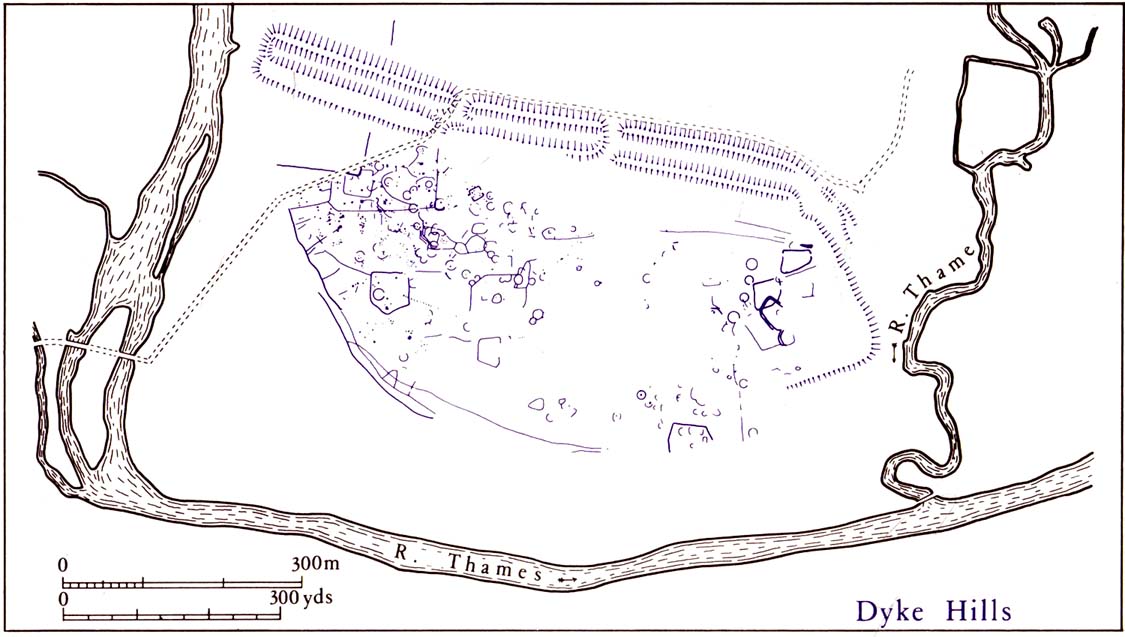
Plan of Dyke Hills (after Cook, 1985)

This site is another example of the considerable neglect shown to the prehistoric archaeological remains in and around the Dorchester region, despite Jean Cook (1985) describing the place as “a site of major local, regional and national importance.”  Which is a pity, as the site here was once huge and it seems that much could have been learned from here.  (you’ve gotta ask: do those doods who allegedly work for English Heritage care more for the ancient sites, or the money their organization gets?)

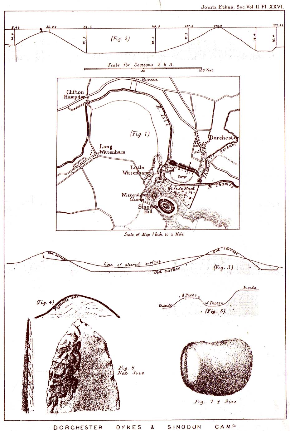
Lane-Fox’s 1870 survey

It would seem that the majority of the site was Iron Age in nature, with snifflings of Bronze Age remains scattered here and there. The primary position of the massive dykes and construction of internal domestic structures immediately below (south) of the dykes, was hemmed in on all sides by the surrounding River Thames and one of its tributaries, giving the place an excellent position in terms of food, plus shelter and protection from any intrusive tribes or hungry winter animals.

The first excavation at the huge dykes that define the northern edge of this ‘monument’ was done in 1870 by the renowned General Pitt-Rivers, then later Colonel Lane-Fox (at the time the Secretary of London’s Ethnological Society), as they were very concerned about the damage that was being inflicted upon the site, when the local landowner allowed sections of the banking to be “reduced for cultivation.”  An article in the Saturday Review magazine on July 2, 1870, told of these concerns and what was written — as Jean Cook so rightly tells — “has a depressingly modern ring to it”:

“…the fortress at Dorchester and the fortress on Sinodun (Castle Hill) are among the most speaking monuments of the earliest history of our island, and till lately they were among its most perfect monuments.  But it is a grievous truth that while we are writing, the dykes at Dorchester are being levelled.  Hitherto the neighbourhood ground has been grazed and the harmless sheep is no foe to history; but it has lately occurred to the owner of the ground hat a few shillings more of yearly profit might be gained by turning pasture land into arable; and to such a sordid motive as this these precious antiquities are at this very moment being sacrificed.  At least a third of the dyke has already been lowered, and will gradually be utterly destroyed beneath the yearly passage of ruin’s merciless plough share.  Such wanton destruction naturally aroused the indignation of men of taste and knowledge, especially in the neighbouring University.  A vigourous appeal to the owner to stay his hand was made by some of the most eminent Oxford residents, and an attempt was made to call public attention to the subject by describing the state of the case in various newspapers…”

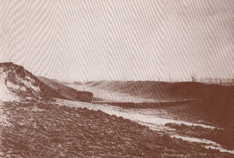
Lane-Fox’s 1872 photo

But the digging into the dykes continued.  For some time at least — until Colonel Lane-Fox himself went to the see the landowner and “persuaded” him to stop what he was doing.  A method we should always keep in mind ourselves…

The modern state of the Dyke Hills is summarised once again in Jean Cook’s (1985) fine survey of the region, where she wrote:

“This great enclosure, known to archaeologists as an oppidum, covered 46 hectares (c. 114 acres) and as defended by a massive double bank and ditch to the north and to the east.  The southern and western boundaries have all but disappeared, but can be traced in lines of modern field boundaries beyond which the Thames forms a natural boundary.  The interior is (now) empty, but cropmarks reveal that it is full of enclosures, pits and circular houses aligned along a regular pattern of internal roads.  Although there has been no scientific excavation within Dyke Hills, ploughing of the site has produced one of the densest concentrations of Iron Age coins in Britain.”

It would appear that this site was of considerable importance for local tribes and would have been home to powerful chiefs and impressive-looking shamans!  The large Castle Hill site immediately across the river would have had obvious links to this once-omportant prehistoric settlement.

References:

  1. Cook, Jean, “Before the Roman Conquest,” in Dorchester through the Ages, Oxford University 1985.
  2. Cook, Jean & Rowley, Trevor (eds.), Dorchester through the Ages, Oxford University 1985.
  3. Williams, Geoffrey, The Iron Age Hillforts of England, Horace Books 1993.

 © Paul Bennett, The Northern Antiquarian


Big Rings Henge, Dorchester, Oxfordshire

Henge (destroyed):  OS Grid Reference – SU 572 953

Archaeology & History

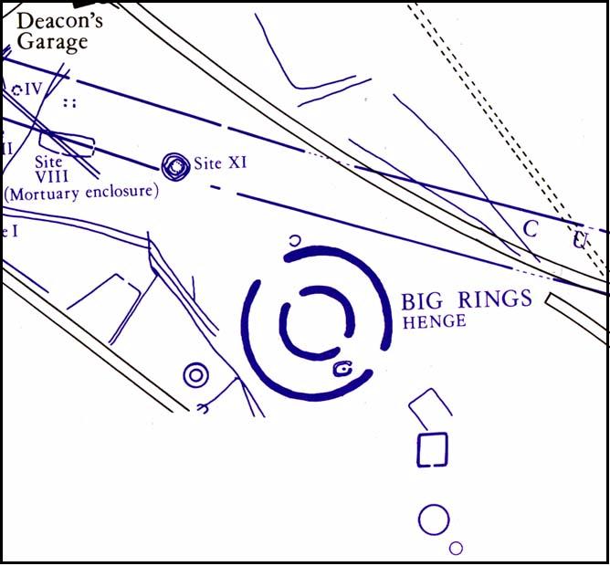
Very close to the once impressive Dorchester Cursus, this double-ringed prehistoric monument can no longer be seen thanks to the self-righteous arrogance of modern industrialists who care little for the ancestral monuments of the British people, destroying all traces of the site — an activity which, in this case, astonishingly started in more ancient times, as Jean Cook (1985) told: “The banks and the ditches had been levelled through agricultural activity, possibly in the Iron Age”!

Big Rings ground-plan
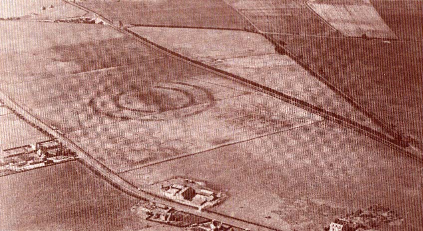
1938 photo of the Big Rings, by Major George Allen

The destruction of this environment continues to this day, destroying many important archaeological remains with little care.  Thankfully we we’ve got a good account of the site due to the archaeological excavations of R.J.C. Atkinson (1951) and his team in the late-1940s, from whom Cook and just about everyone else gets most of their data regarding the site.

The Big Rings Henge was probably built sometime in the middle of the second millenium BC.  It was an important prehistoric ritual site and, most likely, had some relevance to the adjacent cursus monument.  A number of important mortuary and ritual sites were also built close to the site over a period of nearly two thousand years, showing the importance this landscape had to our ancestors.

Jean Cook (1985) described the Big Rings henge as follows:

“The ditches, of which there were two, had opposed entrances on the NNW and SSE.  They were about 7.6m wide and 1.8m deep with flat bottoms.  Originally there seems to have been a broad low bank on the inner side of each ditch.  The southern entrance incorporated an existing monument, consisting of a ring ditch which enclosed a large four-post setting and contained a cremation and a stone axe.  Just outside the north entrance was a round barrow, containing a central oval burial pit which produced a crouched inhumation, together with a well-preserved beaker, two small copper or bronze knives and a rectangular wrist-guard of greenstone.  The Big Rings ditches themselves contained pottery belonging to the middle or late Beaker period.  Although the area within the ditches was trenched, there was no evidence of internal timber structures.”

References:

  1. Atkinson, R.J.C., “The Henge Monuments of Great Britain,” in Atkinson, Piggott & Sandars’ Excavations at Dorchester, Oxon (Department of Antiquities: Oxford 1951).
  2. Atkinson, R.J.C., Piggott, C.M. & Sandars, N.K., Excavations at Dorchester, Oxon, Department of Antiquities: Oxford 1951.
  3. Cook, Jean, “The Earliest Evidence,” in Dorchester through the Ages, Oxford University 1985.
  4. Harding, A.F., Henge Monuments and Related Sites of Great Britain, BAR 175: Oxford 1987.
  5. Harding, Jan, The Henge Monuments of the British Isles, Tempus: Stroud 2003.
  6. Wainwright, Geoffrey J., The Henge Monuments: Ceremony and Society in Prehistoric Britain, Thames & Hudson: London 1989.

© Paul Bennett, The Northern Antiquarian


Dorchester Cursus, Oxfordshire

Cursus:  OS Grid Reference – SU 569 958SU 581 948

Also Known as:

  1. Dorchester-on-Thames Cursus
  2. Overy Cursus

Archaeology & History

Dorchester cursus (after Atkinson)

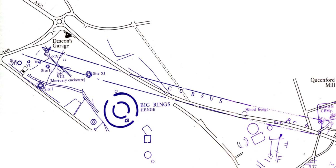
Nowadays marked on modern Ordnance Survey maps as part of a ‘Neolithic Sacred Complex,’ this linear monument was part and parcel of the Dorchester Big Rings henge complex and was associated with a  number of other important prehistoric sites, many of which have been destroyed by ecological disfigurement projects in recent years.  In Gordon Copley’s (1958) description of the monument, not long after its initial discovery, he said that this “was a cursus which consists of parallel ditches some 4000 feet long with 210 feet between them.”  In more recent times Paul Devereux (1989) described how the cursus here,

“ran for three-quarters of a mile (1.2km) in a northwest to southeast direction on the north side of the Thames and was 210 feet (64 metres) wide. The cursus was part of a complex of crop marks, the most notable being” the henge. “The northwest end of the cursus remains unknown; the southeast end was rounded. The southeast segment…was on a slightly skew alignment compared to the rest of the feature, though it may have been the earliest part of the monument – bones found there were radio-carbon dated to around 3000 BC. The southern ditch of the cursus ran through and connected two earlier sites which shared a different alignment. Deposits of cremated bones, a stone arrowhead, fragments of pottery, a polished flint axe, and a circle of pits, probably the remains of a ‘woodhenge’ structure, were all found with the cursus.”

Dorchester cursus plan 1985

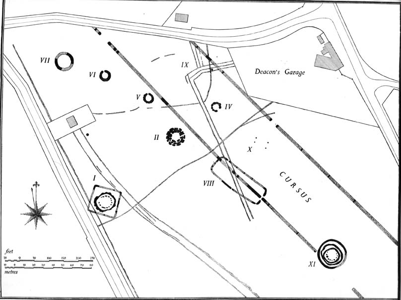
Jean Cook (1985) told that later excavations on the site in 1981, found that the shallow ditch which surrounded the entire cursus, “was interrupted by a central entrance on the southeast side.  The southeastern terminal ditch respected a small prehistoric monument which has been dated to approximately 2000 BC.”  This and other factors has led to the thought that the cursus may not all have been built at the same time.  And indeed excavations at other sites scattering the northwestern ends of the cursus (shown in the plan here, Ed.) proved that a D-shaped enclosure “pre-dates the rest of the structure.”  Other mortuary sites scattered the edges of the cursus that were added in the centuries which followed, but which need excavation work to uncover their secrets.  Although much of this was done in the Atkinson digs, they were summarised well by Jean Cook (1985), who told:

“Site VIII, excavated in 1948, was a monument known as a mortuary enclosure.  Sometimes such structures take the form of long barrows, but this one was a rectangular enclosure bounded on all four sides by a ditch with an internal bank.  There were narrow entrance gaps on the two longer sides and a wider entrance in the centre of the shorter southern side.  It is dated by the substantial sherds of Ebbsfleet ware (pottery) which were found in the upper filling of the ditch; part of a human jaw from within the enclosure helps to confirm the mortuary function.

“Site XI, excavated in 1949, consisted of three or more concentric ditches, of different dates, enclosing an incomplete ring of 14 pits.  The middle ditch seems to have surrounded an oval barrow or enclosure and to have then been converted to a circular plan.  Some of the pits contained animal bones, one contained an antler pick and one contained a complete human cremation, but there were no accompanying grave goods.

“Both these sites were in existence before the cursus was built. (my italics, Ed.)  This is shown by the fact that the southernmost ditch of the cursus cuts through Site VIII and abuts Site XI.  These two earlier sites seem to share the same alignment, but once the cursus was constructed it set a new alignment which may have been of significance until the end of the 3rd millenium BC.  Three monuments built after the construction of the cursus were located inside it, two of them being along the central axis, and two others were just outside the southernmost ditch of the cursus but shared the same general alignment.

“Sites IV, V and VI, which were also excavated in 1949, have a similar overall plan and all of them contained a number of cremation deposits suggesting that amongst other things they acted as cemeteries.  All three sites had a circular plan and consisted of an outer bank, to define the central area, and an inner ditch, the purpose of which seems to have been to provide earth for the bank.  In Site IV the ditch was made up of eight oval pits, enclosing an area of about six metres in diameter.  There was a broad entrance gap on the southeast side.  Inside the enclosed area there were 25 deposits of cremated bones.  An arrowhead was found with one of the cremations.  Site V was very similar in construction, except that the entrance gap was on the northwestern side and contained 21 cremation deposits.  No grave goods were found.  Site VI again had a similar plan with the entrance gap to the north.  There were 49 cremation deposits , one accompanied by a flint fabricator, an arrowhead and burnt flint flakes.

“Site 1 was excavated in 1946 and consisted of a small square ditch, enclosing another more or les circular ditch with an internal bank.  Inside this ditch were 13 holes, forming a ring with an entrance gap on the western side.  There were no entrances in the surrounding ditches.  A crouched burial was found within the entrance to the ring of holes but there were no accompanying grave goods.  Four cremations were found, two accompanied by fragmentary bone pins, in or besides four of the central holes.  At a later stage in the neolithic period, parts of the ditch may have been enlarged to make temporary shelters: it is not clear to which period of use the cremations belong.

“Site II, also excavated in 1946, consisted of a causewayed (interrupted) ring ditch which was enlarged on two occasions.  The third ditch had an internal bank in which were 19 cremation deposits.  Two more cremations were found at the centre of the enclosed area.  There was no evidence for any gap.  Bone pins were found with four of the cremations as were flint fragments.  In addition, antlers and other flint fragments were found, as well as pieces of pottery.

“In 1981 a small semi-circular enclosed ditch was excavated within the southeast terminal of the cursus.  Though sited off-centre, the ditch shared the same alignment with the cursus.  An antler (dated to c.2000 BC) was found close to the bottom of the ditch.  After the ditch had virtually filled up with silt, the surviving low central mound was used for cremation deposits, one of them associated with a heavily burnt flint blade.”

Paul Devereux (1989) pointed out how one of the archaeologists studying this site found that if the axis of the monument was extended southeast, across the river, it lined up perfectly with another set of perfectly straight lines which were thought “likely to be a Roman trackway.”  Unfortunately much of this area has been destroyed through the self-righteous ignorance of modern industrialism.

References:

  1. Atkinson, R.J.C. et al, Excavations at Dorchester, Oxon, Department of Antiquities: Oxford 1951.
  2. Barclay, A., Lambrick, G., Moore, J. & Robinson, M., Lines in the Landscape, OAU: Oxford 2003.
  3. Cook, Jean, “The Earliest Evidence,” in Dorchester through the Ages, Oxford University 1985.
  4. Cook, Jean & Rowley, Trevor (eds.), Dorchester through the Ages, Oxford University 1985.
  5. Copley, Gordon J., An Archaeology of South-East England, Phoenix House: London 1958.
  6. Loveday, Roy, Inscribed Across the Landscape, Tempus: Stroud 2006.
  7. Pennick, Nigel & Devereux, Paul, Lines on the Landscape, Hale: London 1989.

© Paul Bennett, The Northern Antiquarian