Cup-and-Ring Stone (lost): OS Grid Reference – Q 508 001
Archaeology & History
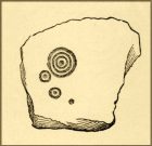
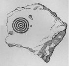
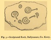
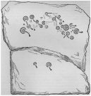
An impressive multiple cup-and-ring stone was discovered near the beginning of the 20th century by Rev. Orpen (1908) who gave a reasonably good description of its whereabouts and, thankfully, a sketch of the basic design. But since his day, it’s not been seen again. He told us that after,
“Leaving the Church of St. Martin, and passing down the main road towards Dingle, we take a turn to the left, and cross the river to the village of Furacht. Here, on the farm of Mr. Brosnan, about 300 yards up the hill towards the south, may be seen a carved stone…marked with cups and concentric circles. The stone is about 6 feet long by 4 feet wide. It was partially covered with sods of grass, which, when they were cleared away, revealed some other cups and circles. This stone lies on one of the ditches running north and south on Mr. Brosnan’s farm.”
The grid-reference given for this site is taken from Judith Cuppage’s (1986) fine survey, who had no success finding it. But a stone of this size shouldn’t be too difficult to locate—unless it’s either covered in vegetation or it’s been destroyed. Do any Lispole or Dingle folk know what’s become of it?
References:
- Cuppage, Judith, Archaeological Survey of the Dingle Peninsula, Oidhreacht Chorca Dhuibhne: Ballyferriter 1986.
- Orpen, R., “Antiquities near Lispole, Co. Kerry,” in Kerry Archaeological Magazine, volume 1, 1908.
Acknowledgements: Huge thanks for use of the Ordnance Survey map in this site profile, reproduced with the kind permission of the National Library of Scotland.
© Paul Bennett, The Northern Antiquarian
The map could not be loaded. Please contact the site owner.


