Sunset Stone, Silsden, West Yorkshire

Cup-and-Ring Stone:  OS Grid Reference – SE 06745 45368 

Getting Here

Sunset Stone cupmarks

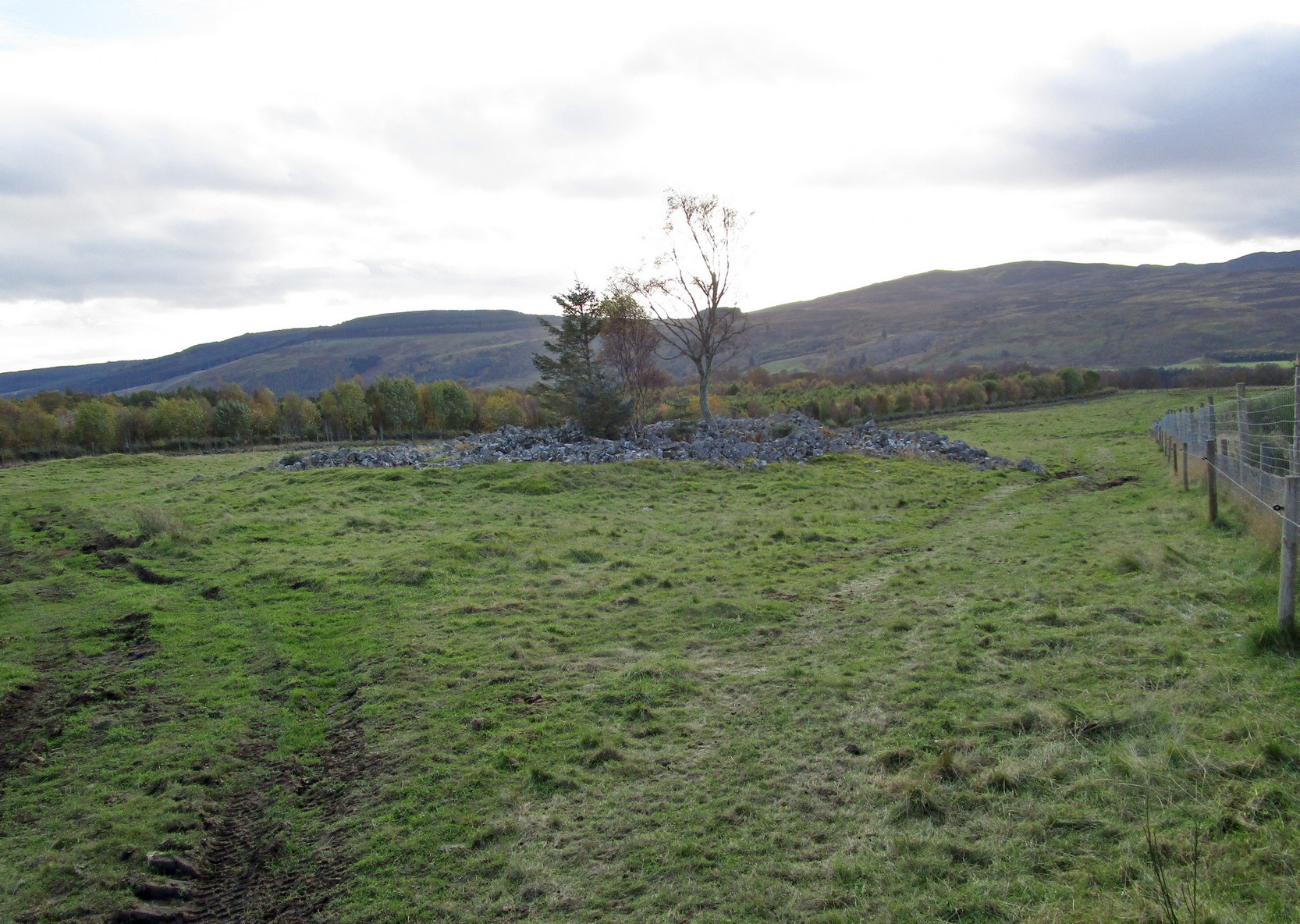
Along the B6265 old road between Keighley and Bingley, at Riddlesden go up Granby Lane, bending left into Banks Lane.  About a mile up you’ll reach the moorland road.  Turn left at the junction and nearly half-a-mile along there’s a layby on y’ right.  From here walk along the footpath on the edge of the ridge, half-mile along bending slightly above Rough Holden Farm until, a coupla hundred yards on, you hit the dirt-track.  There’s a long straight stretch of walling on your left: follow this for a few hundred yards, go through the gate and here walk on the other (left) side of the wall (if you’ve reach a derelict farm, you’ve gone too far).  Some 60 yards or so down here, keep your eyes peeled on the long earthfast stone right near the walling.  An alternative is to start at the steep hairpin bend up Holden Lane and follow the footpath into the woods. Walk along here (parallel with the stream below) for about 600 yards until you hit the bridge crossing the stream. Don’t cross over: instead double-back up the field on your right, go diagonally across and through the gate into the next field, and walk up along the walling to your right.  160 yards up, go through the gate and walk about 30 yards along the side of the walling again.  Tis there!

Archaeology & History

Unveiling the Sunset Stone

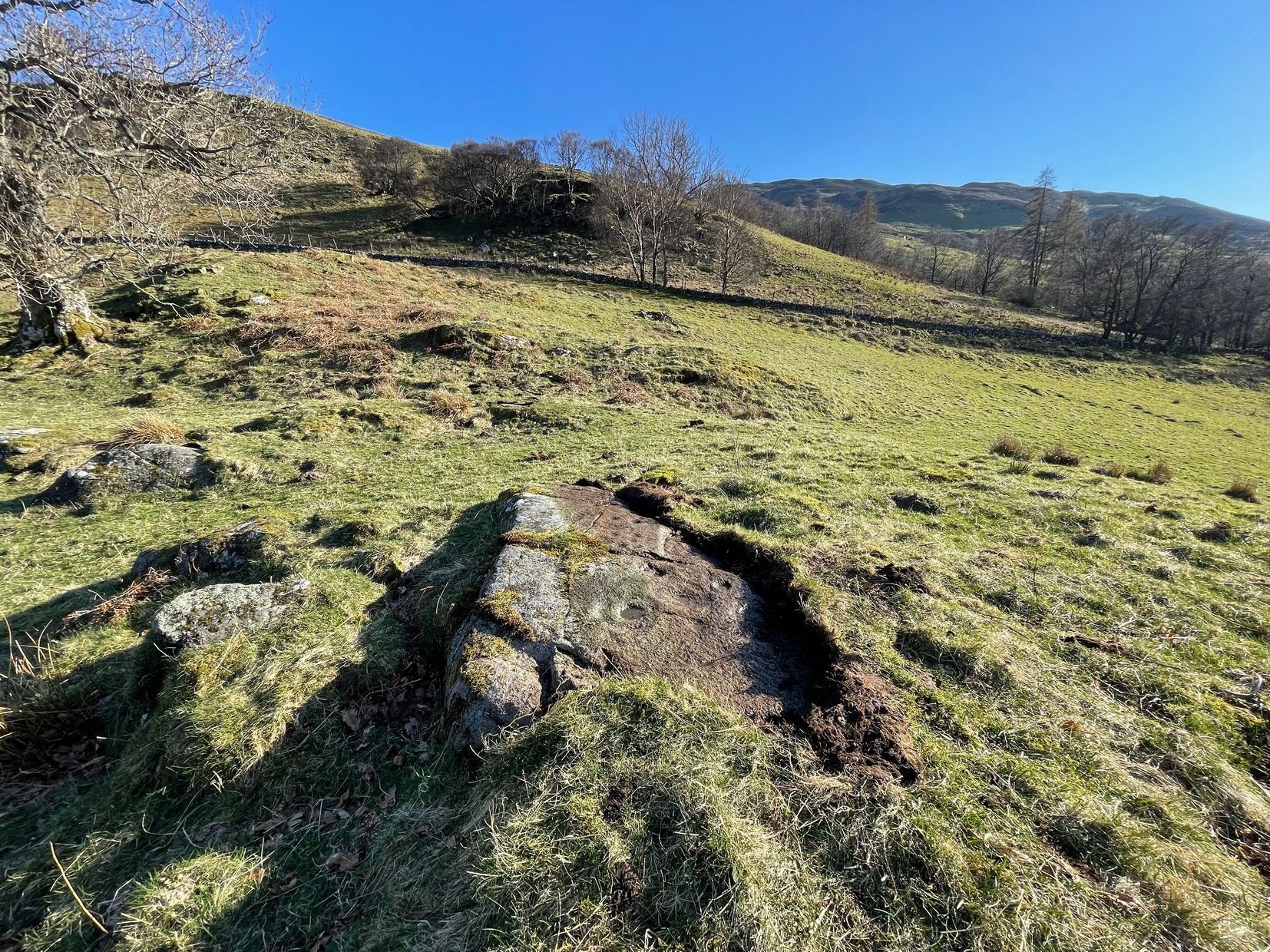
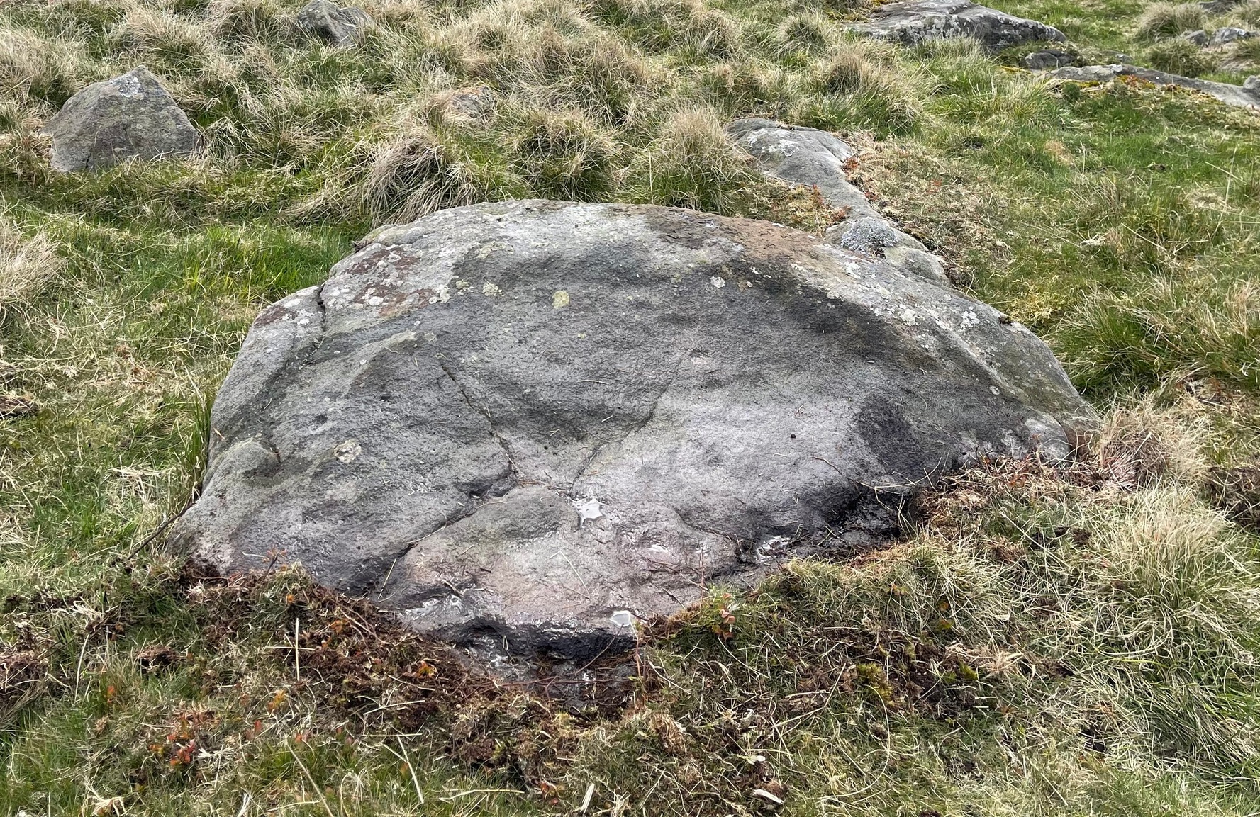
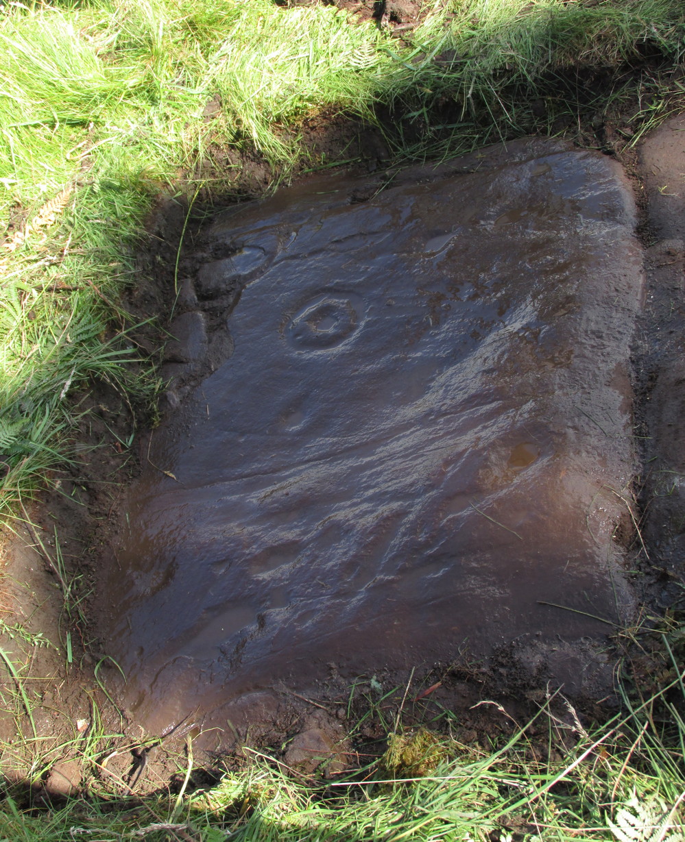
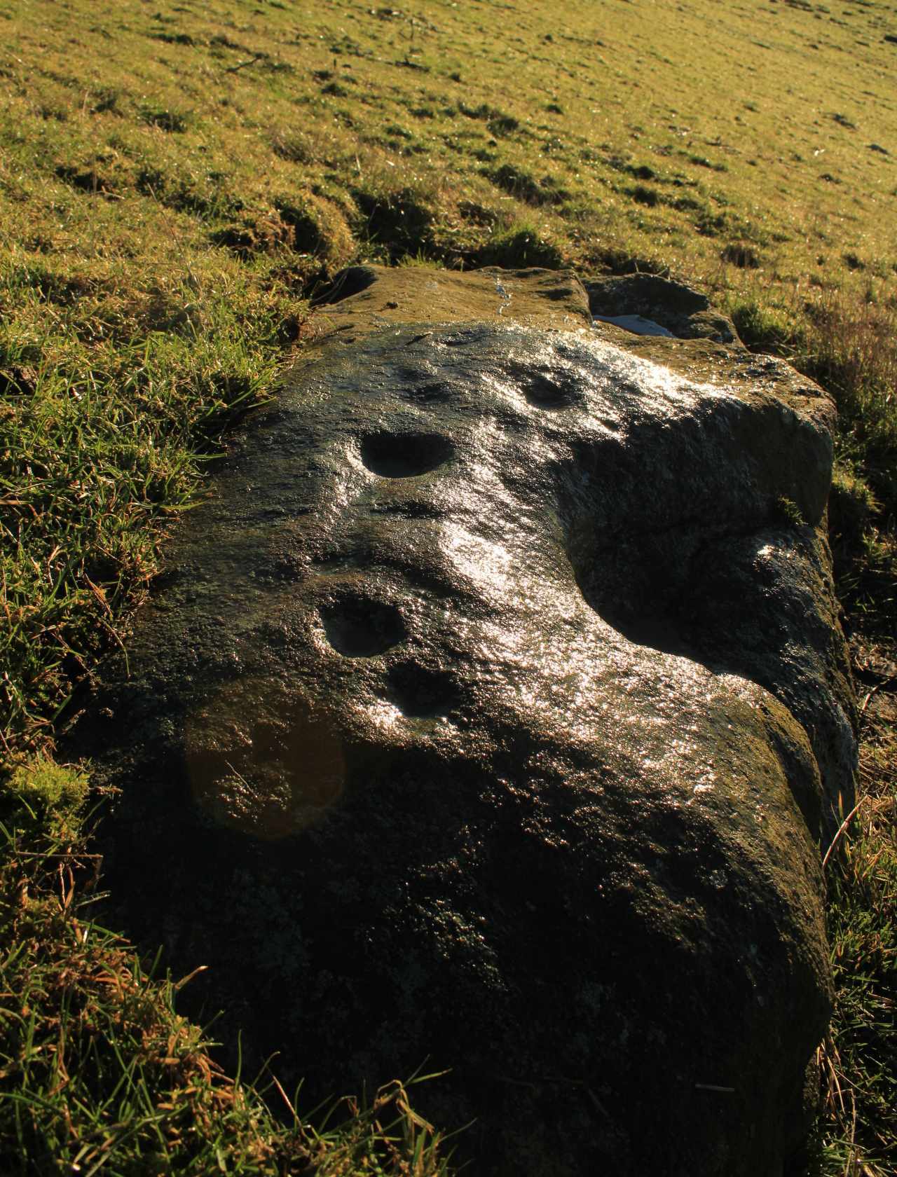
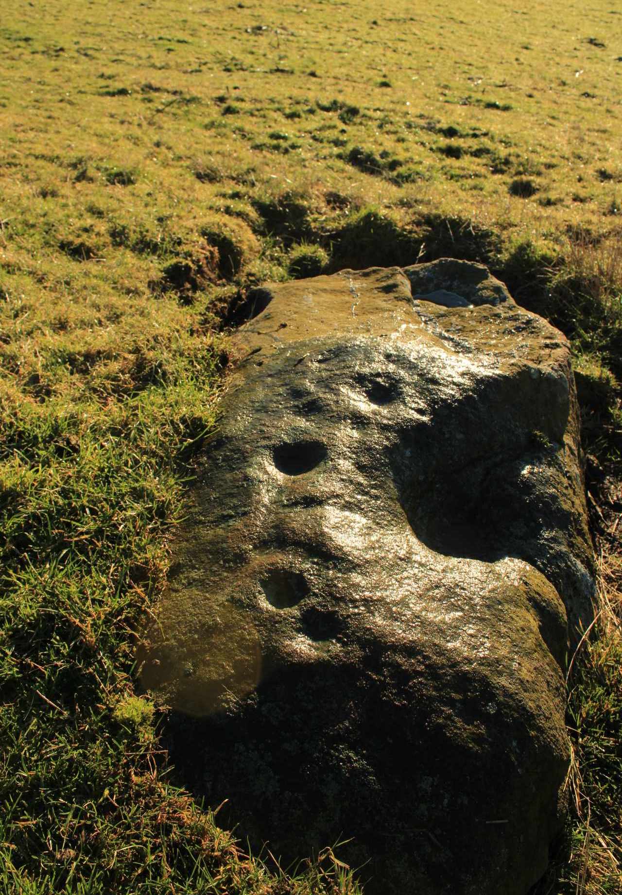
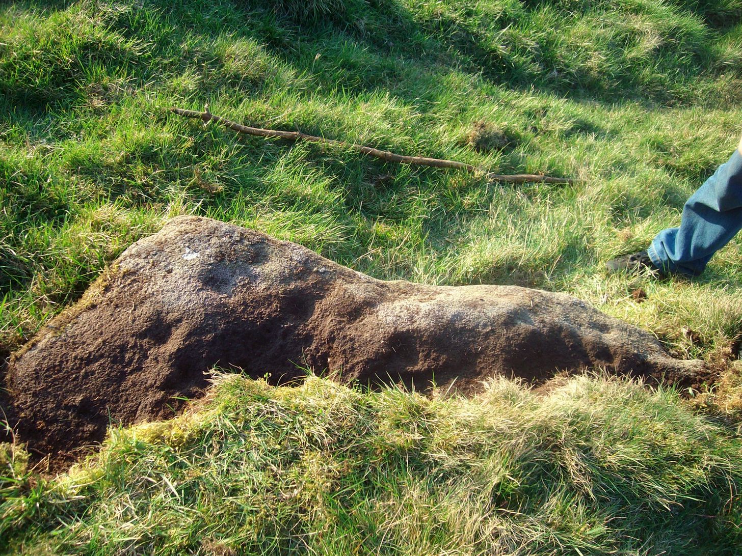
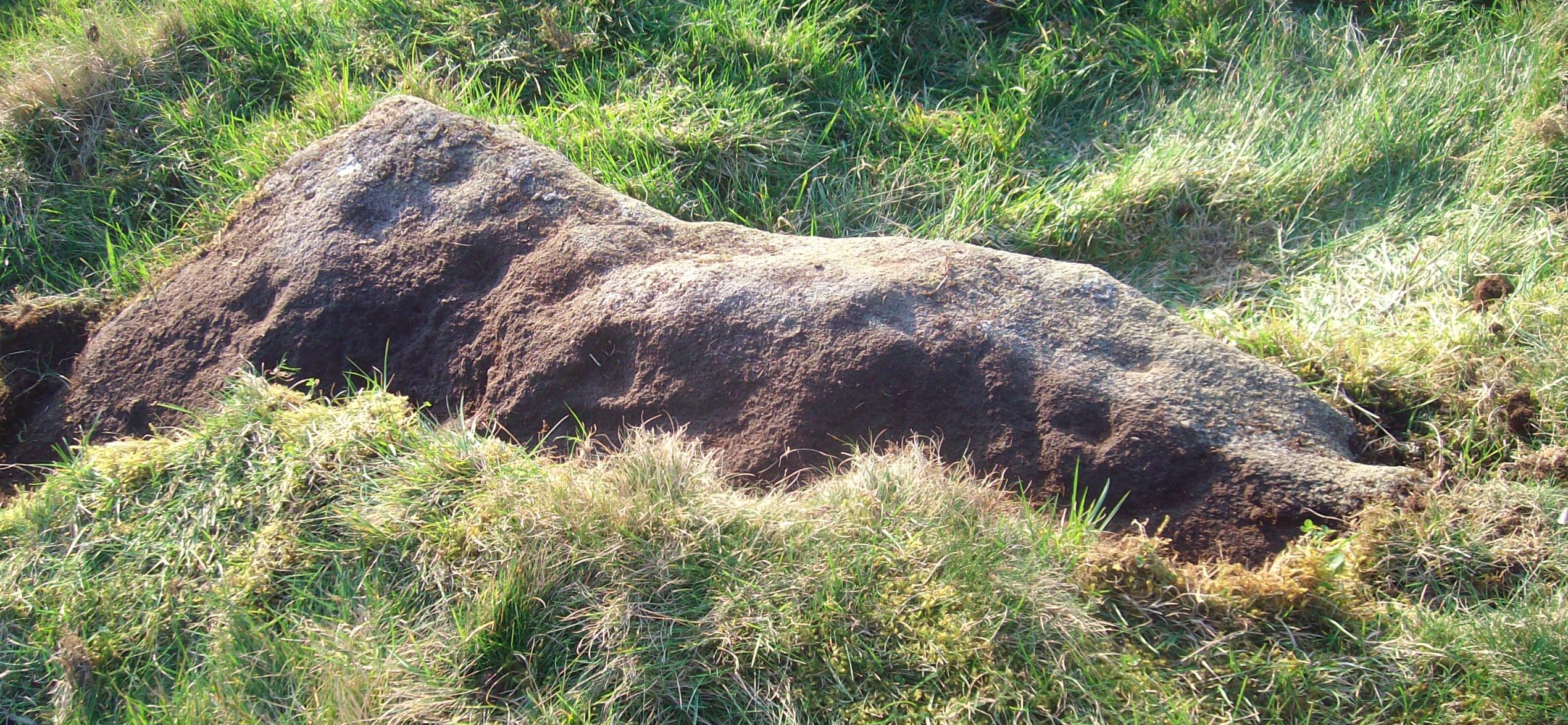
This is a fascinating carved stone on the western edge of Rombald’s Moor that I was fortunate to find in 2008.  It’s found in association with two other cup-marked stones, north and south of it.  I first noticed it when I was walking along the footpath by the side of the wall and saw that on a small exposed part of the rock a single cup-marking carved close to the vertical edge of the stone—and I’m glad that I stopped to give it more attention.  The stone was very deeply embedded and the covering soil so tightly packed that I could only shift a small part of it—but the section that I  managed to uncover and, importantly, the time of day when I did this, brought about an intriguing visage with subtle mythic overtones.

Carved arc on edge
Early photo in low light

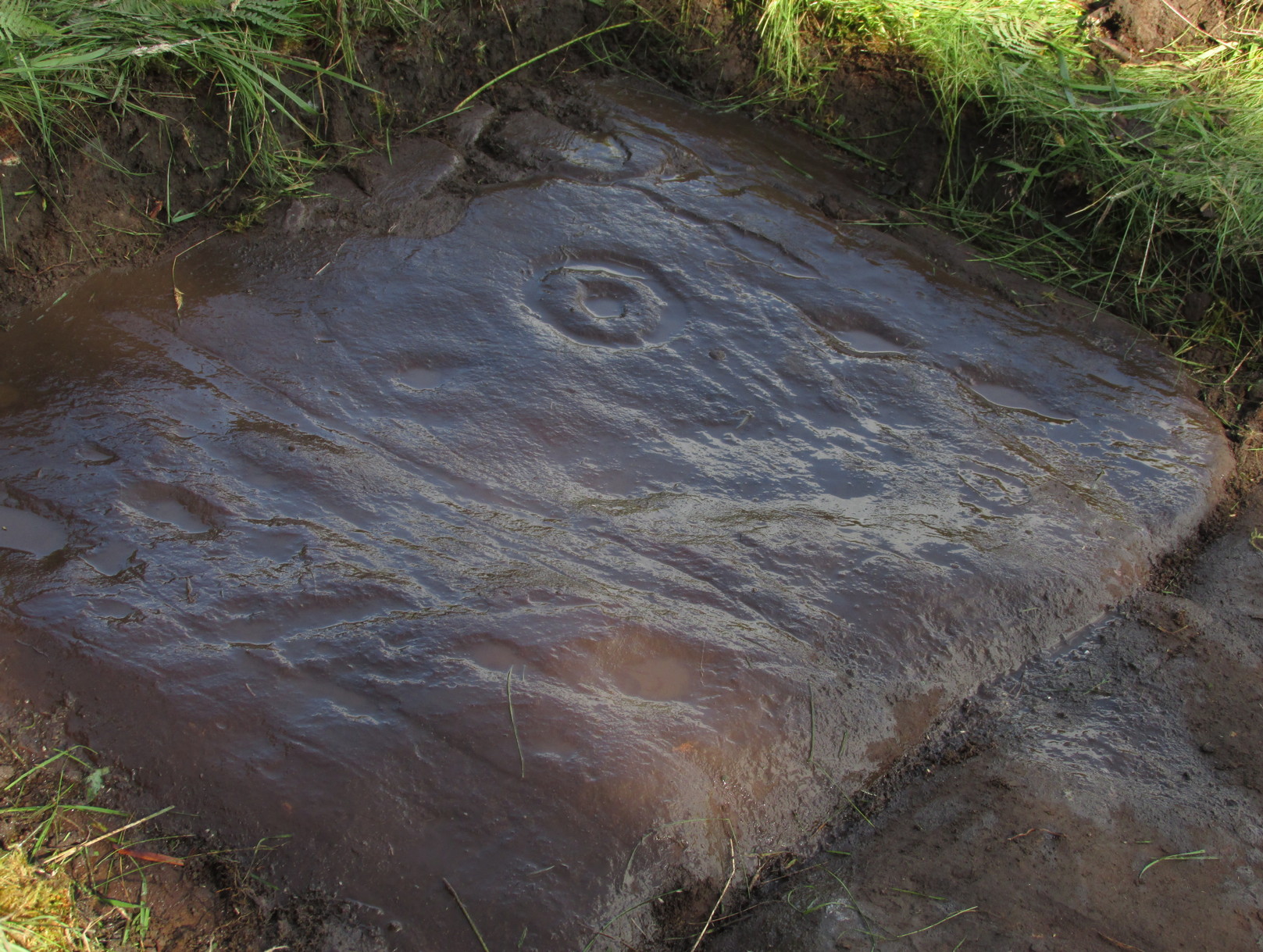
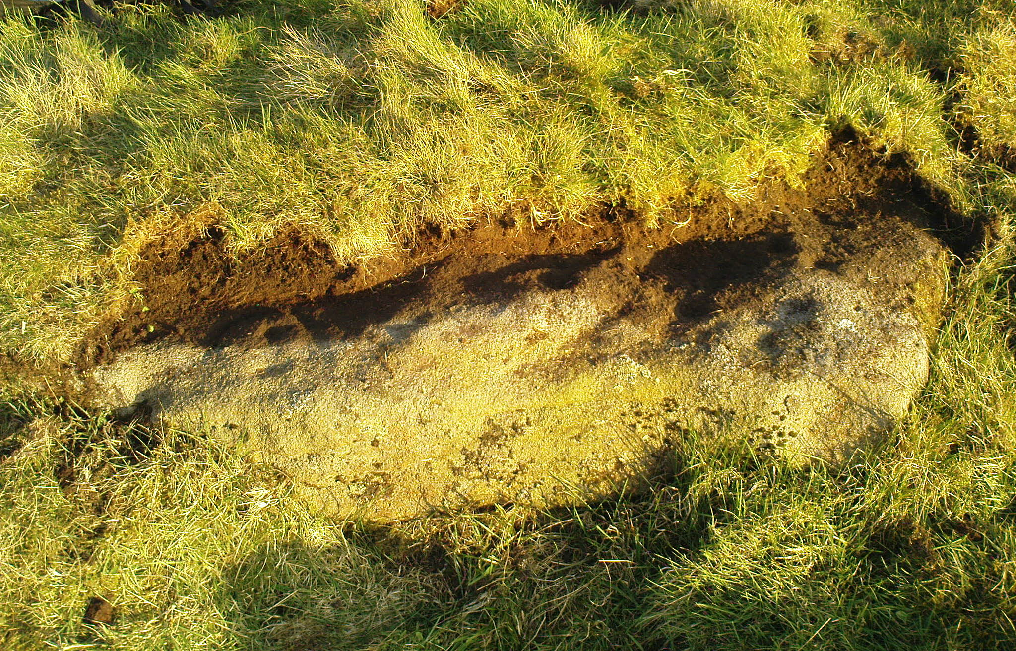
The carving was found near the end of the day just as the sun was setting and touching the far horizon.  I noticed there was a cup-and-half-ring to the side of where I’d sat for a rest, near the northern edge of the stone, and the clear but soft light of the evening caught this element and almost brought it to life!  As I gazed down at the half-ring, the sun highlighted it even more and I saw that some extended carved lines continued and dropped over the near vertical edge of the stone, becoming an unbroken elongated ‘ring’ that stretched twice the length of the half-ring on the flat surface.  Not only that, but a faint cup-mark seemed to be inside this extended vertical ring and, as I saw this, a dreaming epiphany hit me that the symbolism behind this was a representation of  the setting sun that I was watching at that very moment.  It was quite beautiful and the carving seemed to come to life.  The thought, nay feeling, that this part of the carving symbolized a setting sun not only slotted easily into a common animistic ingredient, but hit me as common sense too!  However, as my ego and rational sense rose back to the fore (I had to get mi shit together and walk a few miles home before night fell), I saw that this impression may be a completely spurious one; but, as the rock-face inclines west, towards the setting sun, the name of Sunset Stone stuck.  As I carefully fondled beneath the heavy overgrowth of vegetation covering the stone, I realised that I needed to come here again and uncover more of it, as additional cups and lines seemed to be reaching out from the mass of soil.

Cups near the S edge
Close-up of ring-edge

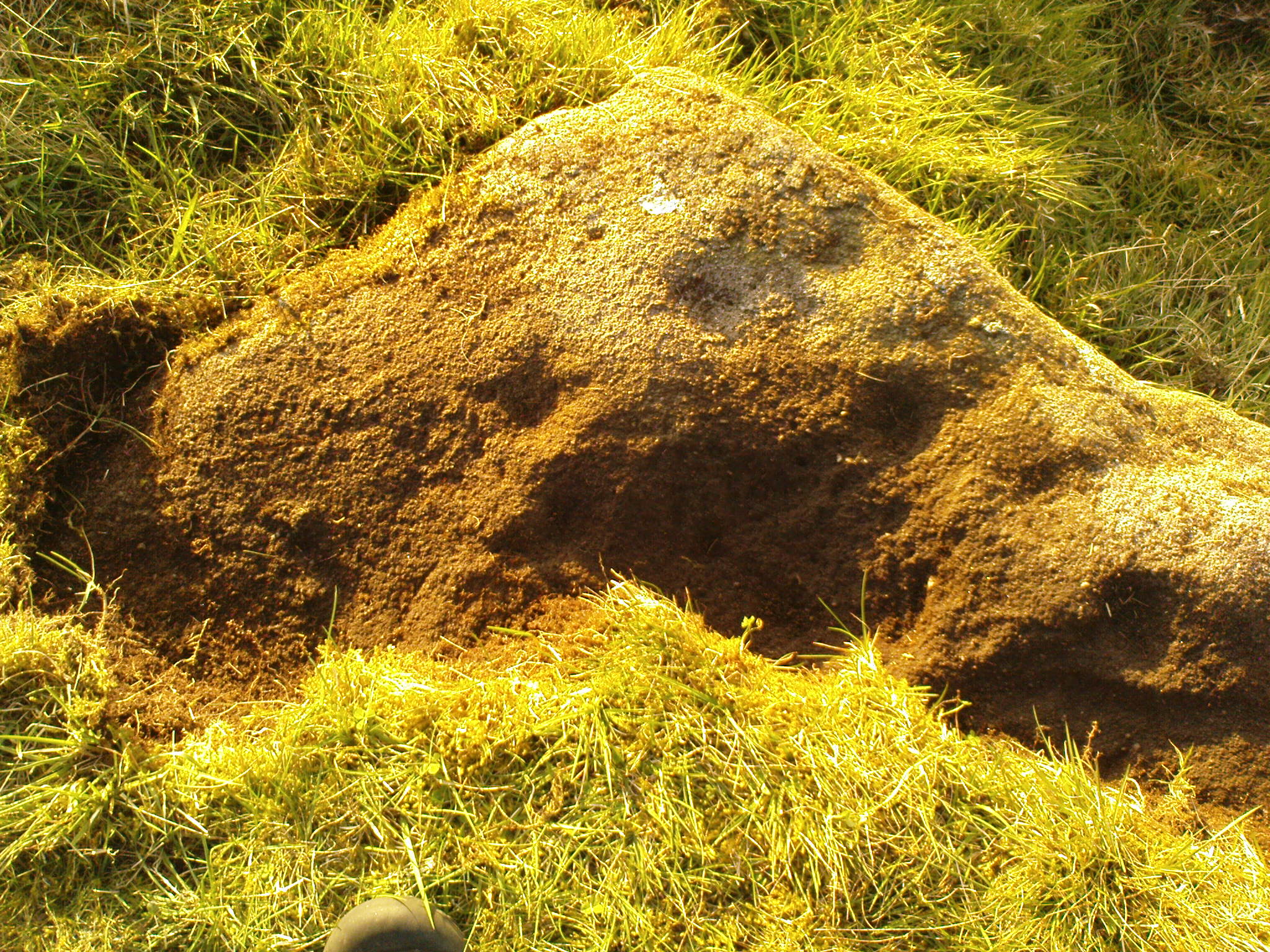
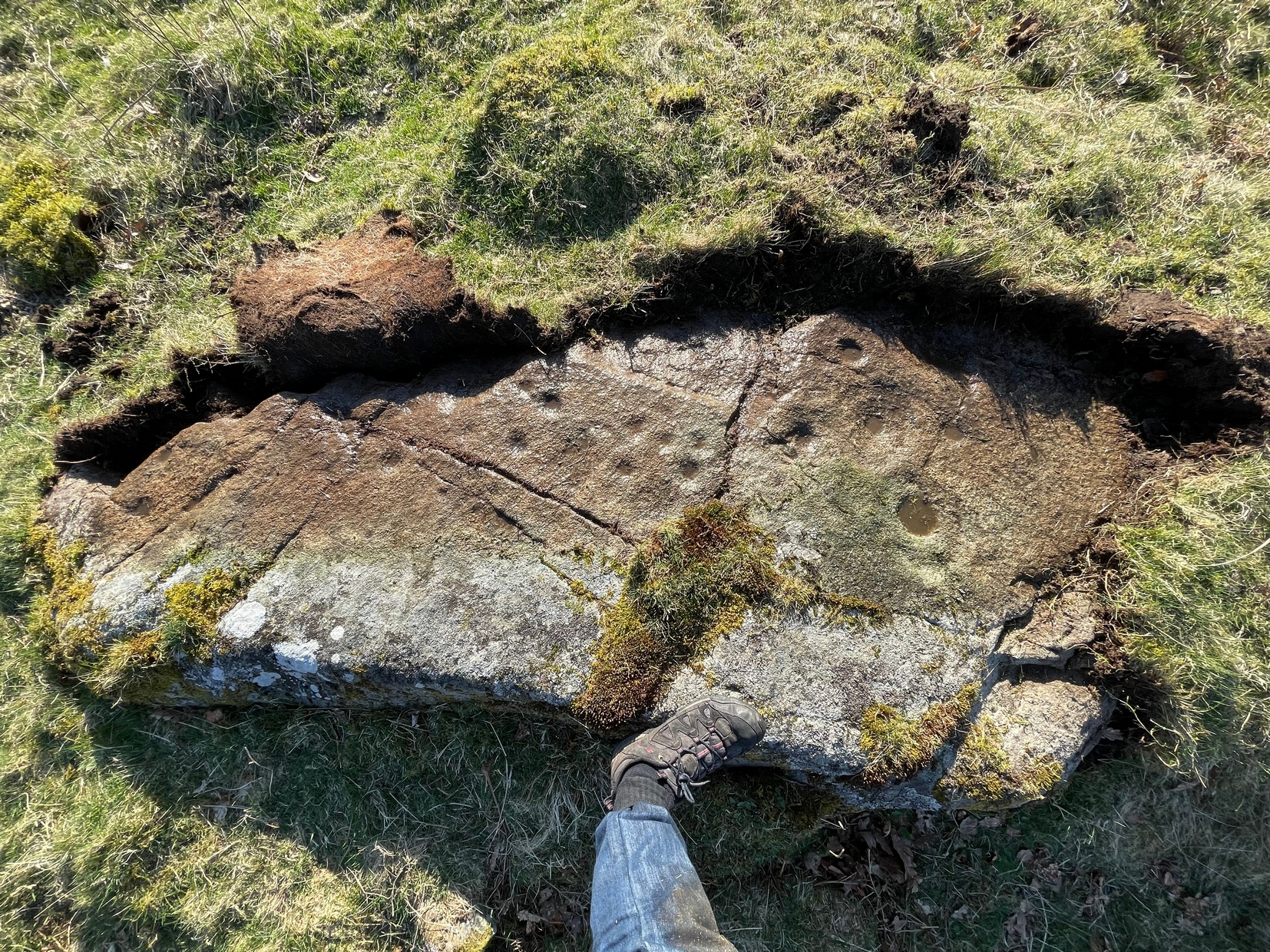
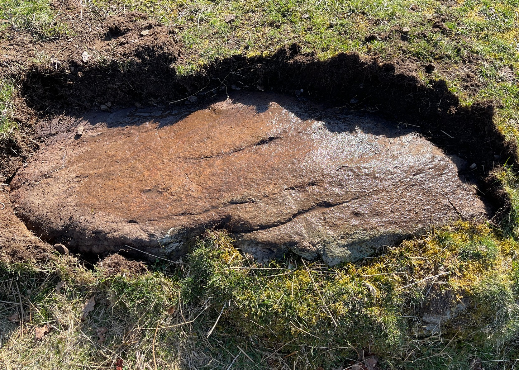
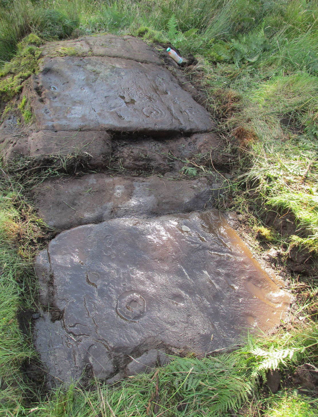
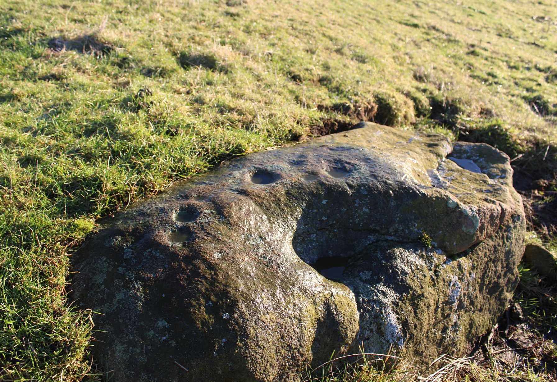
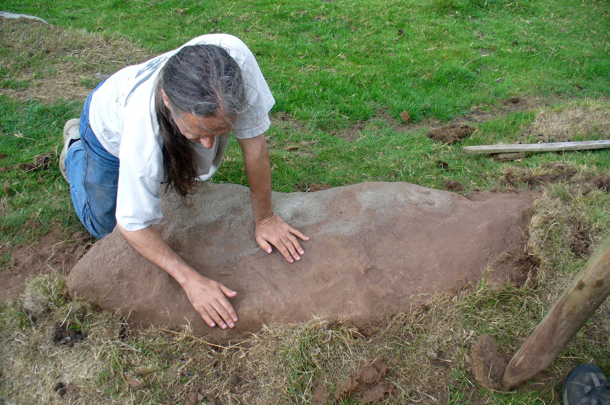
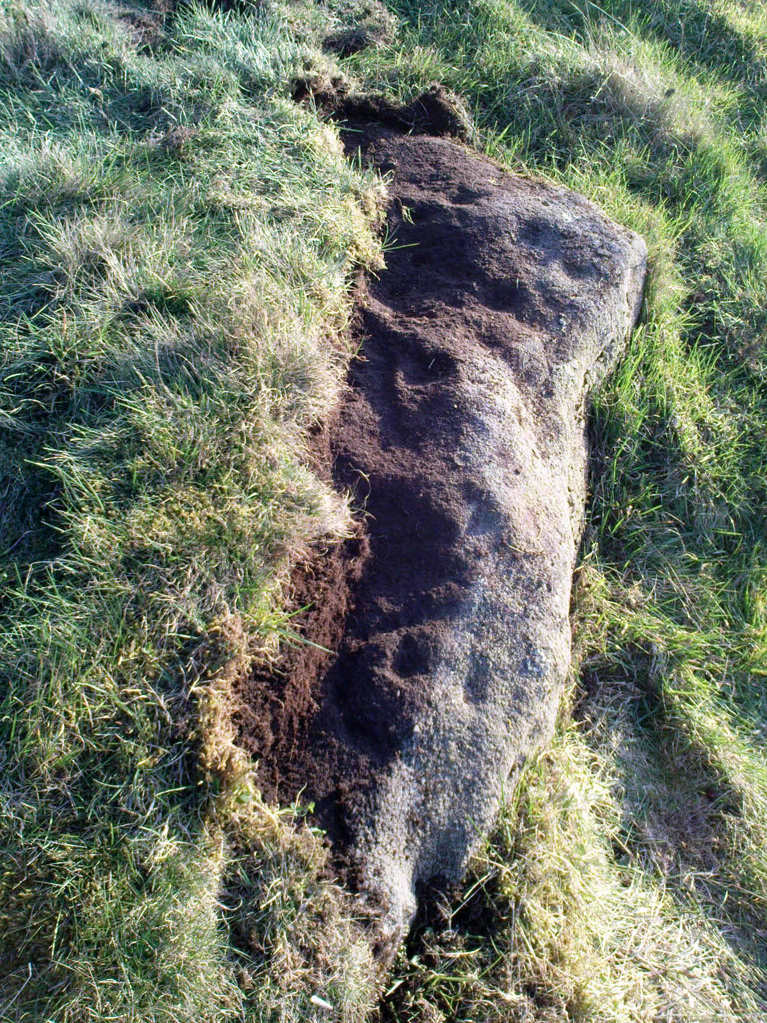
I returned to the stone a few times, but it was several years that I revisited the site with the intention of uncovering more of the design in the company of Richard Hirst and Paul Hornby on August 4, 2013—and it took considerable effort to roll back the turf that covered the stone.  But it was worth it!  For it soon became obvious that much of the stone that was covered over had been unexposed for many centuries: as Richard pointed out, the edge of the rock was very smoothed by weathering, whilst the covered section of the stone that we were revealing was still quite rough and misshapen all across the surface, lacking weather and water erosion.  Much of this design therefore, highlighted itself to us as it was when the mason first carved the stone.  And it turned out to be a pretty curious design!

Faded photo of the Sunset Stone
Faded photo of the carving
Faint proto-ring nr centre

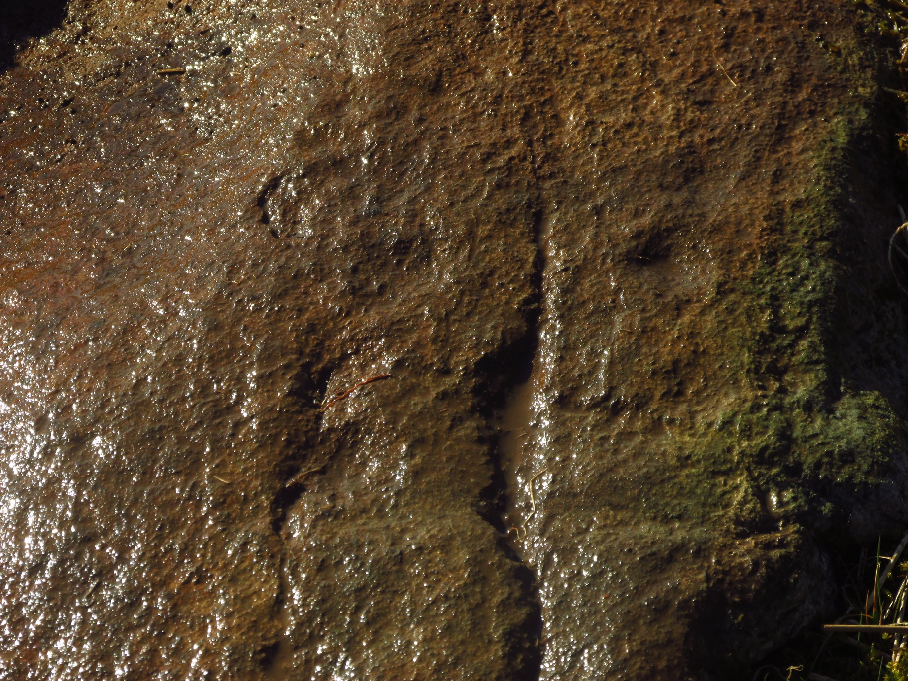
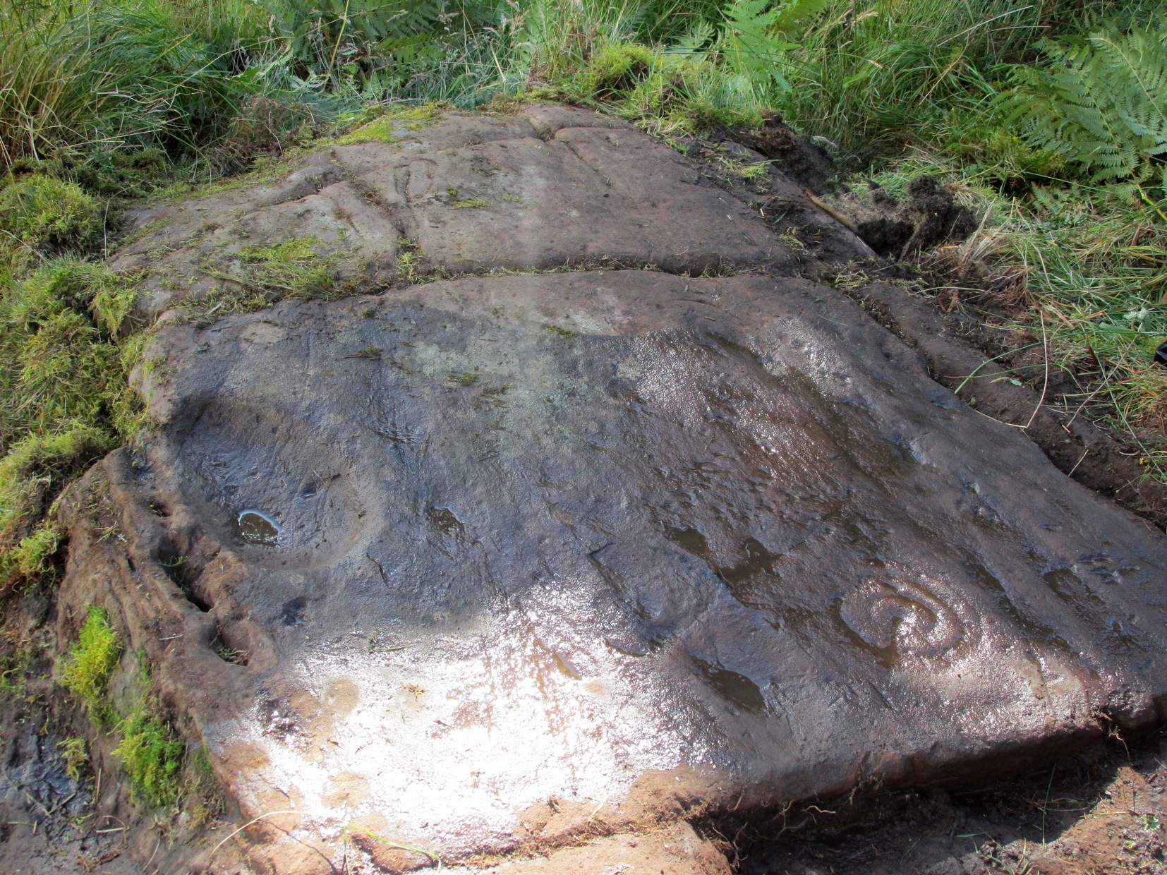
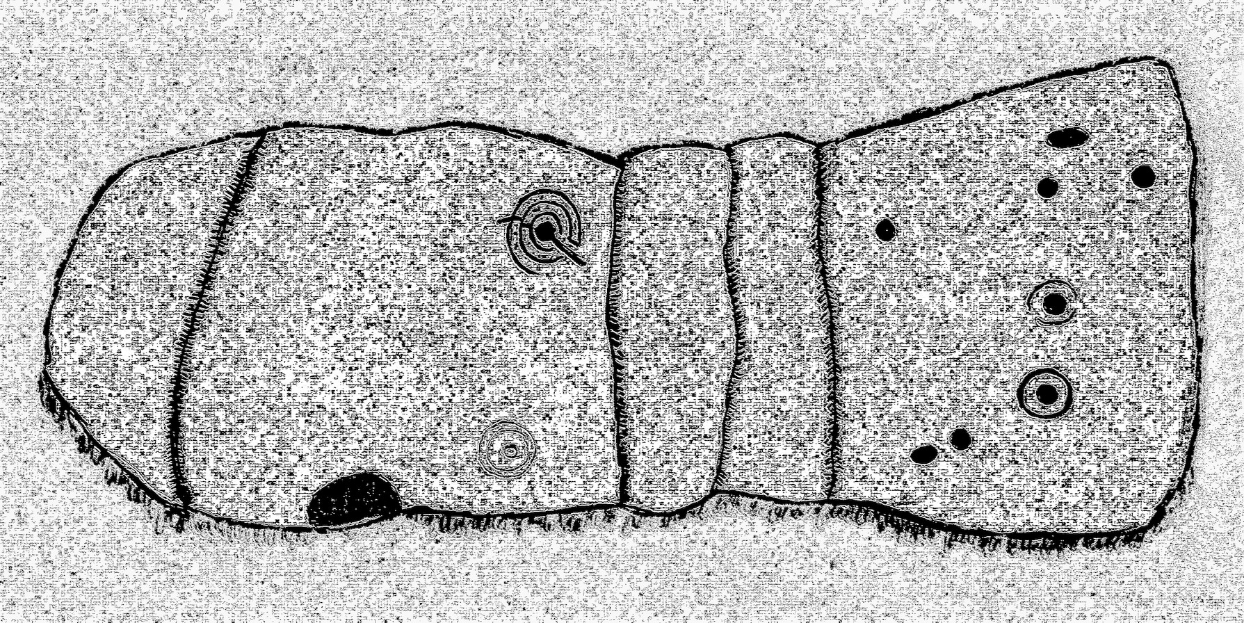
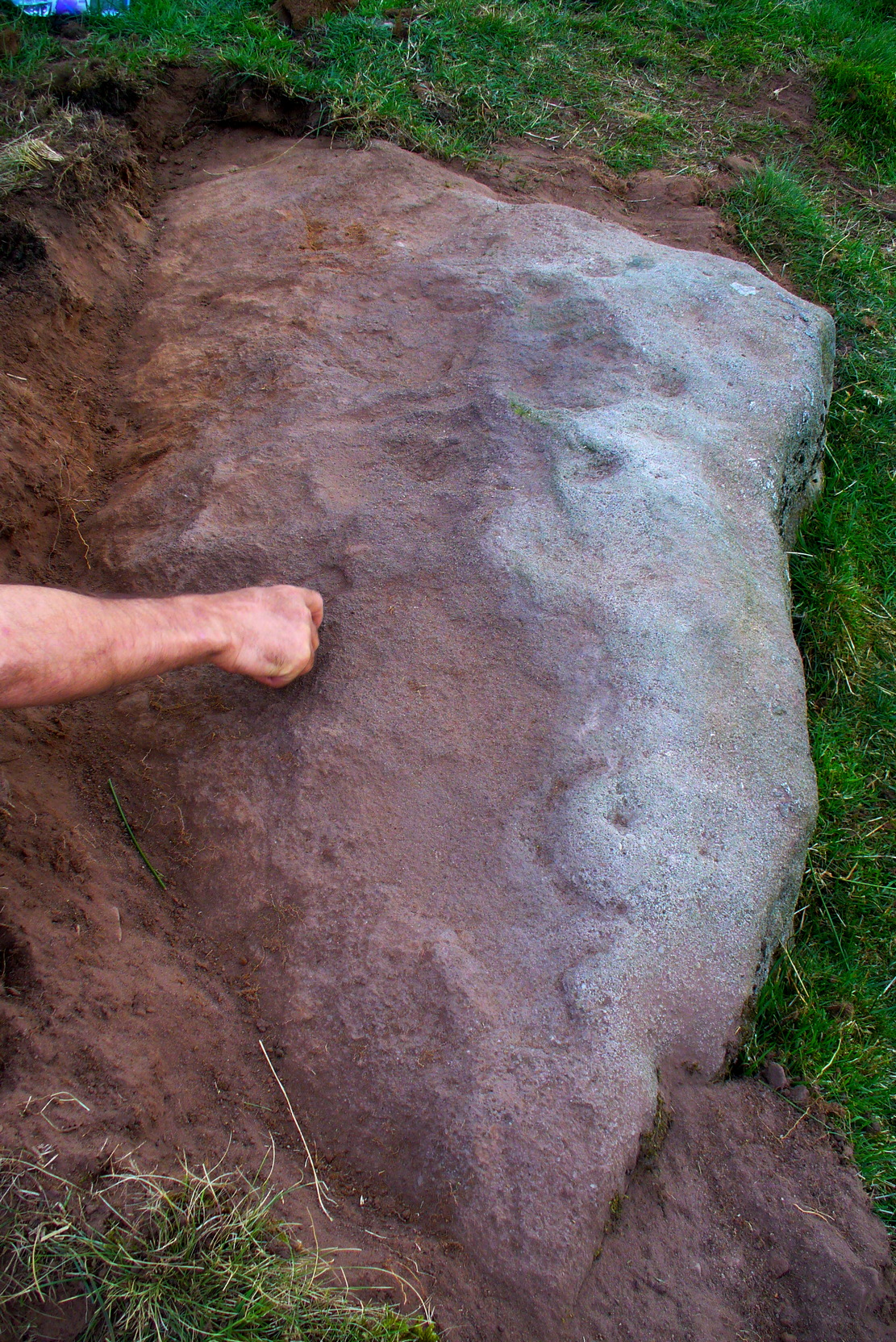
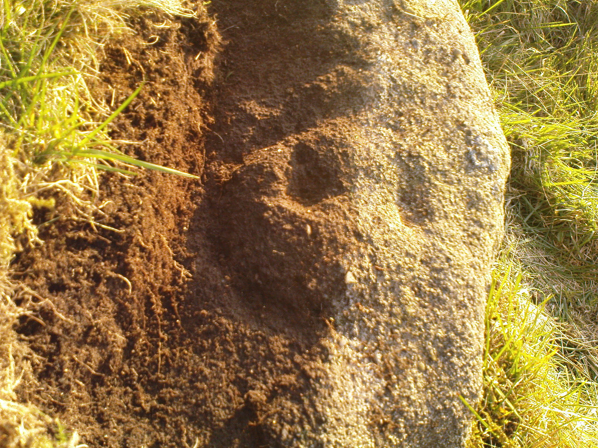
Our first impression was that the design comprised of two cup-and-rings near the middle of the rock, with another cup-and-drooping-ring near the northern edge of the stone, and between ten and twelve typical cup-markings, many on the western exposed side.  But curiously near the middle were also a couple of rings whose edges had been defined, but the hollowed-out ‘cup’ in the middle remained uncut or unfinished, being a proto-ring, so to speak.  Also, lines leading from these unfinished ‘cups’ were also pecked and laid out, but they were also unfinished.  Some sections of the unfinished lines ran onto the western edge of the stone and were very faint, but they were undeniably there.  Unfinished cups is an unusual feature for carvings on Rombald’s Moor.

Mr Hirst’s clearance
Cups & curves on edge

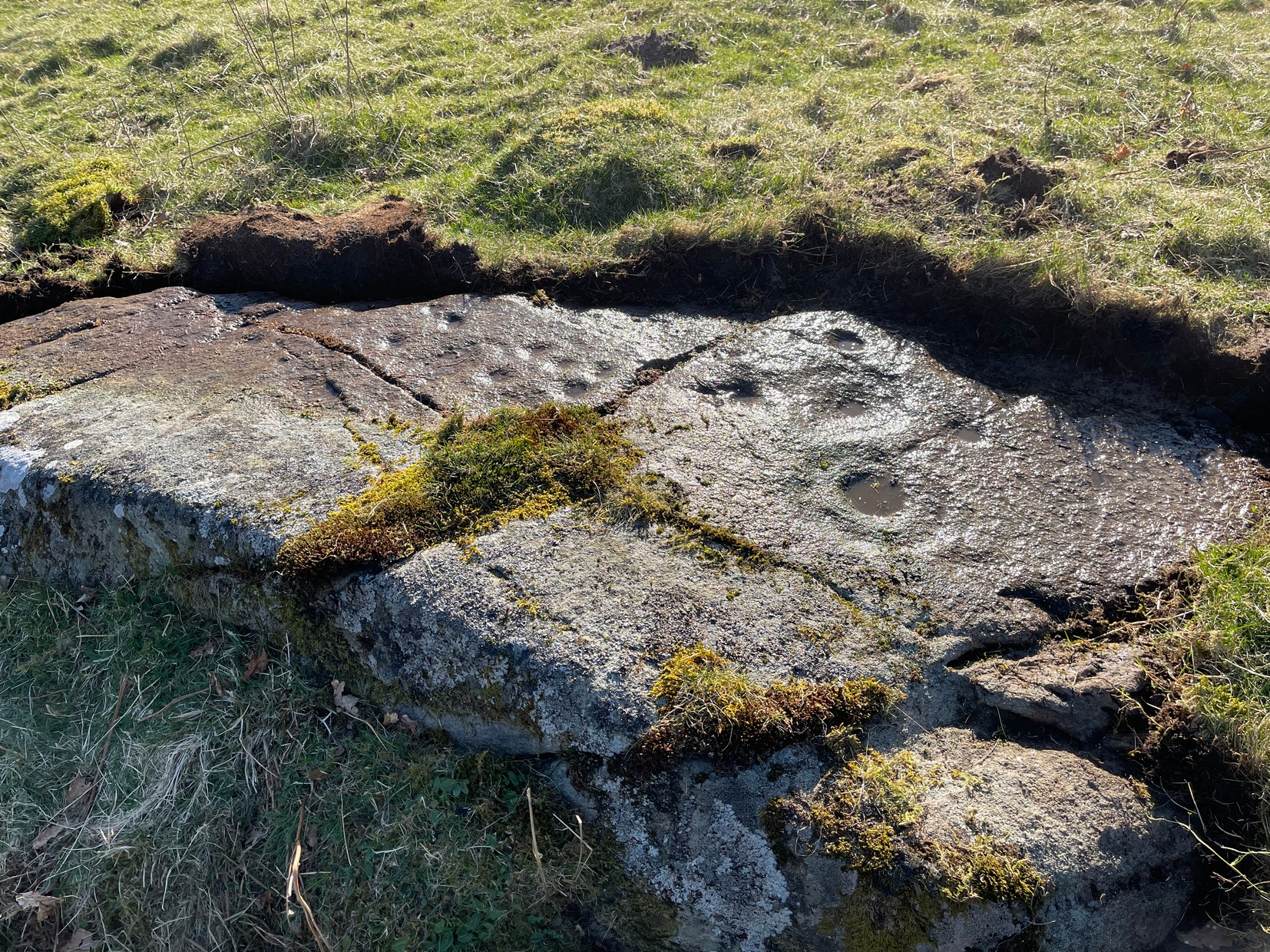
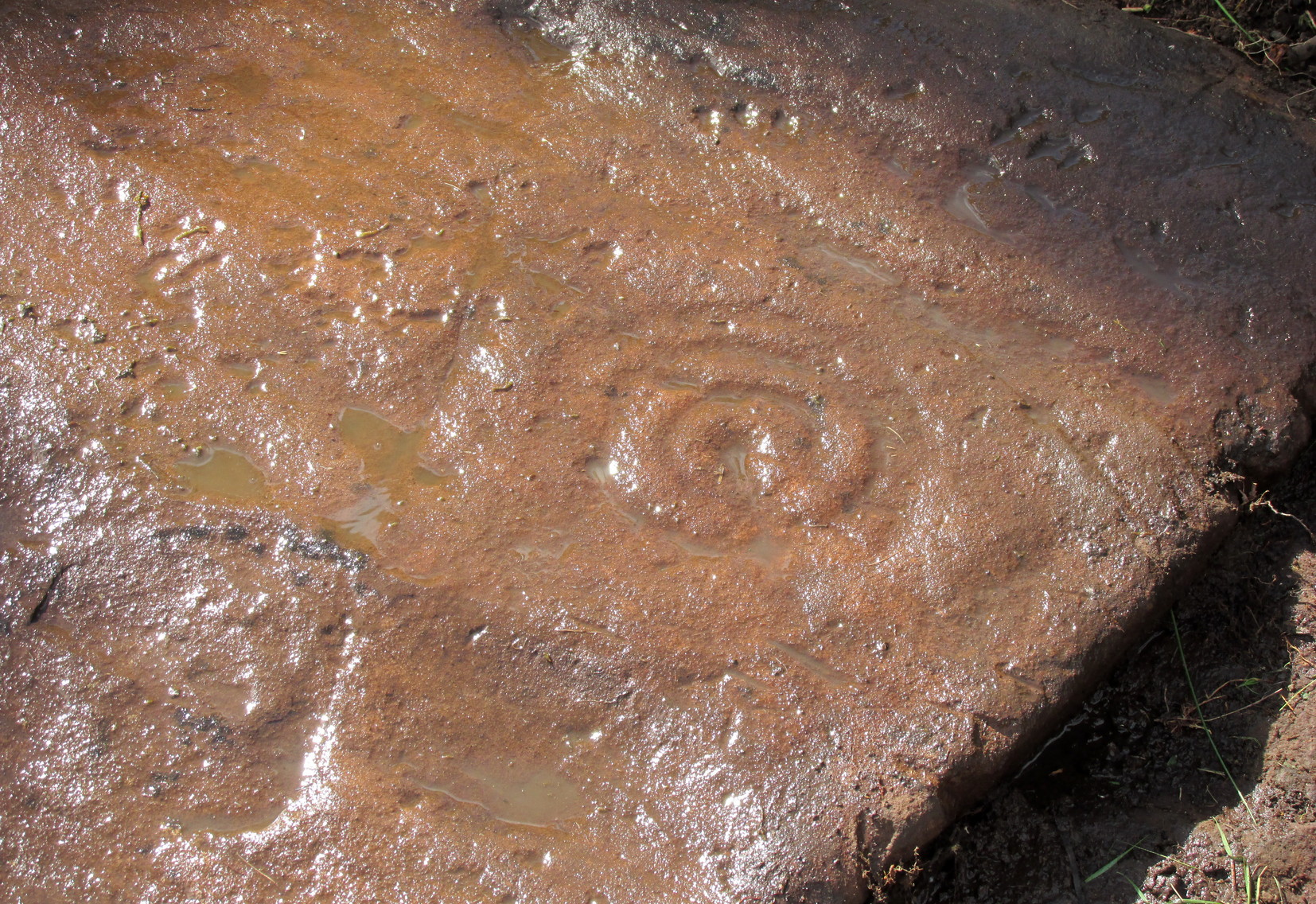
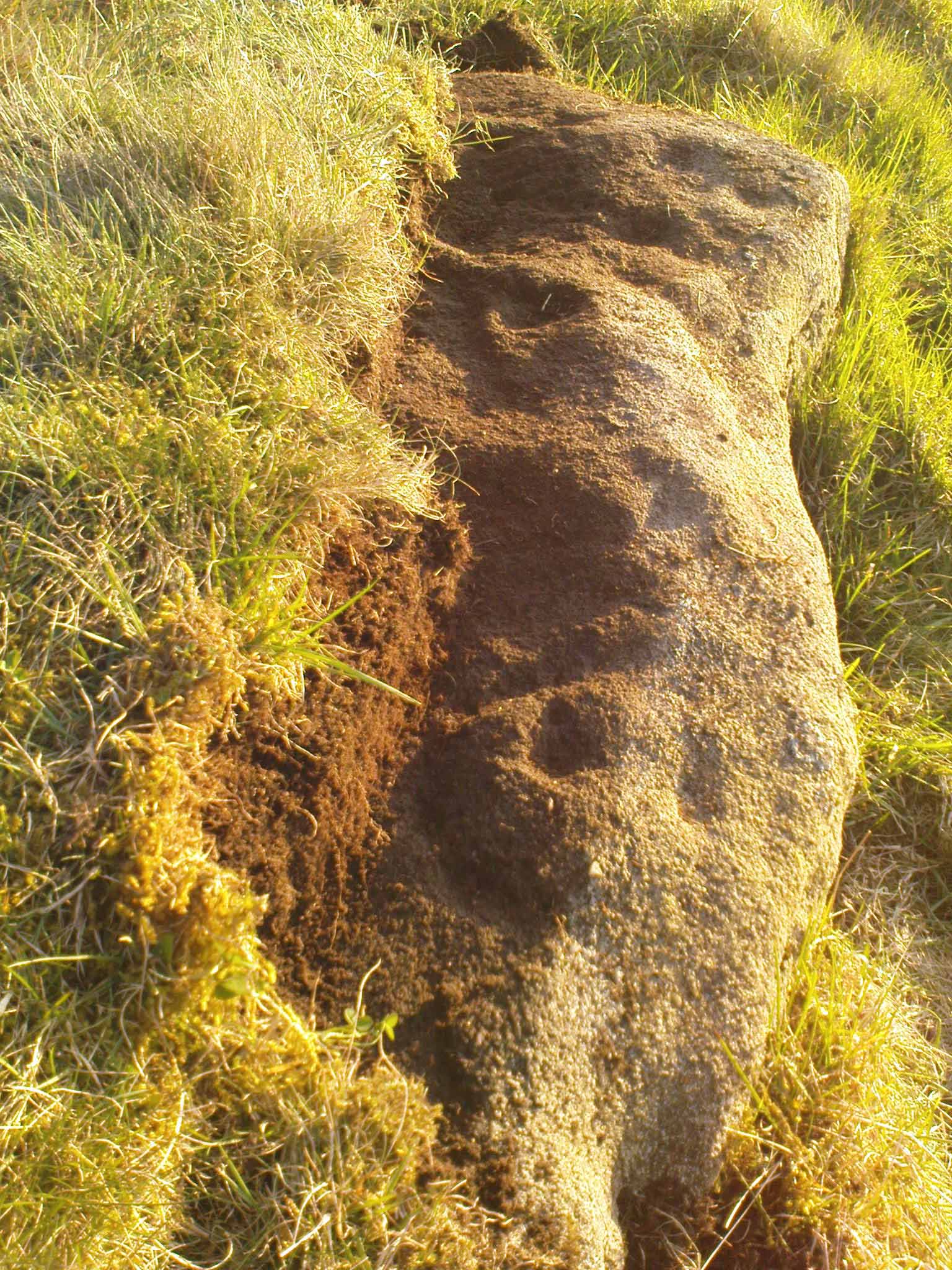
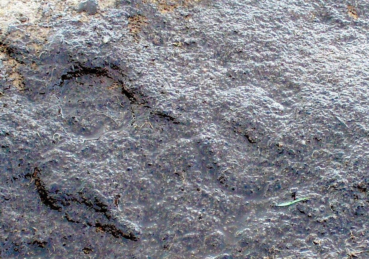
But the most interesting element in the fainter, seemingly unfinished carved lines, was what may be a small spiral that started above the two faint cup-and-rings.  This then continued in a sharp arc which doubled-back on itself.  In the other direction, the lines curve round and go down to the vertical face of the rock, before bending back up onto the level surface again, then disappearing.  The topmost cup-and-half-ring is also a curious feature.  When you visit here you’ll see how this aspect of the design looks for all the world like a simply cup-and-half-ring near the edge of the stone.  But, as I’ve already mentioned, closer examination shows that this “half-ring” has a larger oval body beneath it on the vertical face of the stone, very worn due to its exposure to the elements and very much in the shape of a bell—and within this large cup-and-ring ‘bell’ is a much fainter complete cup-and-ring, just below the topmost cup-marking.  I know that I’ve already mentioned this, but I’m giving it added emphasis as it’s a unique design element for carvings on these moors.

Early photo of the carving
Edge of the carving

The Sunset Stone really requires more attention, when the daylight conditions are just right, so that all of these intriguing aspects can be highlighted with greater lucidity.  There is also the potential that more carved ingredients remains hidden beneath the compacted soil.

What seems to be a more trivial single cup-marked stone can be seen roughly 20 yards to the north.

Acknowledgements:  Massive thanks to Richard Hirst of Hebden Bridge, and Prof. Paul Hornby, for their help in bringing this carving to light.

© Paul Bennett, The Northern Antiquarian

The map could not be loaded. Please contact the site owner.

Balimeanach (3), Loch Earn, Comrie, Perthshire

Cup-and-Ring Stone:  OS Grid Reference – NN 64118 22897

Getting Here

Balimeanach (3) carving

Loch Earn (between the villages of Lochearnhead and St Fillans) has a road running on each side: the north-side is the A85, the south-side is a minor single-track road.  You need to be on the south-side. Roughly halfway along the loch, there’s rough parking near Ardvorlich House; and from the track to Ardvorlich, keep on the lochside road, walking east for about 400 yards and then go up the dirt-track on your right.  Walk up here for 450 yards until your reach the cottage. There’s a field above you to the left with some small crags near the top: walk uphill (through the gate) for 175 yards and on the topmost crags you’ll see a telegraph pole.  The cup-and-ring stone is right next to it!

Archaeology & History

The first and only reference to this stone followed its rediscovery by George Currie (2011) in one of his many bimbling forays seeking out these old carvings.  He told, in his usual minimalist manner that,

“A stretch of bedrock adjacent to a telegraph pole on a terrace above Balimeanach farmhouse bears thirteen cup marks, at least two of which have single rings, including the largest at 70 x 25mm.”

Line of cup-and-rings
View from above

The two cup-and-rings are next to each other on the northen side of the stone, with one based on a small concave depression in the rock itself; but next to this is what seems to be another, third and very faint incomplete cup-and-ring (you can see it in some of the photos here).  We walked round and round this and whilst it seems quite obvious, some elements of it appear to be based on natural cracks in the stone, accentuated with minimal pecking by the artist.  These three cup-and-rings are next to each other in a veritable Orion’s Belt formation, with a single cup hanging down from the middle.

Carving, looking south
Looking across the design

The other main section of the carving consists of a series of plain cups, scattered in a typically chaotic form and clustering mainly round the centre of the stone; whilst on its southern tip a single cup sits quietly.

When we peeled the turf back to see the entire carving, we found there was a considerable scatter of broken quartz all along the western edge of the stone.  This element was also found at the Balimeanach (2) carving less than ten yards away and we’ve found this at a number of other petroglyphs in Perthshire and beyond.  Even more intriguing was a large carved stone spearhead covered in soil alongside the quartz scatter!  We left this where we found it.

In all probability, there are other carvings that remain undiscovered beneath the turf all along this ridge.  Get y’ gardening gloves out!

References:

  1. Currie, George, “Comrie: Balimeanach (BC 3), Cup-marked Rock”, in Discovery & Excavation Scotland, New series – volume 12, 2011.

© Paul BennettThe Northern Antiquarian

The map could not be loaded. Please contact the site owner.

Millstone Hill, Bradley Moor, Skipton, North Yorkshire

Cup-and-Ring Stone:  OS Grid Reference – SE 01343 50223

Getting Here

Millstone Hill carving

In High Bradley village, you need to go up Mill Lane for 140 yards and then bear left up High Bradley Lane for just over a half-mile, past the last row of houses on your left where it becomes a dirt-track and park-up a short distance up here. 400 yards up, in the field past the new house on your left, walk up the hill over the field, past the wall at the top and head for the large protruding boulder a few hundred yards further up on the near skyline.  Once here, walk to the right of it and there’s a scatter of rocks and stones.  Look around!

Archaeology & History

In an area that was extensively cut up by the Industrialists in the 18th and 19th century, Thomas Cleland came across this scarce example of a cup-marked, possibly cup-and-ring marked stone in March 2025 high up on Millstone Hill, where extensive views reach out to the south, east and west, gazing with particular attention to the mightily impressive King and Queen’s cairns, more than 1½ (2.6km) south of here—and which would have stood out much more back then than they do today.

Close-up of faint arc

An arc of cups is faintly visible on the more western-side of the stone—five, perhaps six of them.  Several others are in a typically chaotic scatter across the rock, with one or two looking as if they may have been affected by the heavy industrial actions that occurred up here.  When Tom first found the carving, he could see a faint ring around one of the cups near the middle of the stone, but on our visit here the sun was near its apogee and due to the slope of the rock to the north where the cups are carved, this was nigh on impossible to make out.  Near the bottom edge however (as shown in the photos), a cup-and-incomplete ring seems evident; although we didn’t notice this on our visit here and it may just be a fortuitous play of the light (but I hope I’m wrong!).  This is a design that mainly comes to life, so to speak, is more easily visible, when the sun is either rising or setting. (typical of many petroglyphs on flat rocks)

Acknowledgements:  Huge thanks to Thomas Cleland for use of his photos in this site profile. 

© Paul BennettThe Northern Antiquarian

The map could not be loaded. Please contact the site owner.

Riffa Wood, Leathley, North Yorkshire

Cup-Marked Stone (lost):  OS Grid Reference – SE 2556 4687

Also Known as:

  1. Carving no.556 (Boughey & Vickerman)

Archaeology & History

We know very little about this carving, which was first highlighted on Eric Cowling’s (1940) map of Wharfedale petroglyphs.  Described simply as one of the “cup-marked rocks”, he mentioned it briefly in Rombald’s Way (1946) as being “the most easterly carving” in mid-Wharfedale—which it was at the time (a very recent find by Benn Potts of a cup-marked stone at Weeton has pushed the boundary further eastwards).  Oddly for Cowling, he left no further notes nor sketch of the carving and when Stuart Feather (1961) came to write of it, he merely copied Cowling’s earlier words.  It’s not been seen since.  In Boughey & Vickerman’s (2003) survey, they could find no cup-marked stone in the wood but thought instead that,

“this may be due more to confusion than to loss of the carving.  Riffa Wood does contain a carving: of a Native American on a conspicuous rock alongside one of the many woodland paths. Furthermore, one or two local residents recall a German prisoner carving something on a rock in Riffa Wood during the Second World War.  Presumably, this is the origin of the Native American carving.  Could it be that this man added something of his own to what was already a carved rock, in which case the Native American as he now appears is the site noted by Cowling before the War?”

No cup-marks exist on this Native American carving, and it’s highly unlikely that Cowling would have made such an elementary mistake.  The carving no doubt lies covered in woodland vegetation waiting, once more, for the day that someone comes along and exposes its visage to the world again.  Let us know if you manage to find it…

References:

  1. Boughey, Keith & Vickerman, E.A., Prehistoric Rock Art of the West Riding, WYAS: Wakefield 2003.
  2. Cowling, E.T., ‘A Classification of West Yorkshire Cup and Ring Stones,’ in Archaeological Journal, volume 97, 1940.
  3. Cowling, E.T., Rombald’s Way: A Prehistory of Mid-Wharfedale, William Walker: Otley 1946.
  4. Feather, Stuart, “Mid-Wharfedale Cup-and-Ring Markings,” in Cartwright Hall Archaeology Group Bulletin, volume 6, no.3, March 1961.

Acknowledgements:  Huge thanks for use of the Ordnance Survey map in this site profile, reproduced with the kind permission of the National Library of Scotland

© Paul BennettThe Northern Antiquarian

The map could not be loaded. Please contact the site owner.

Balimeanach (2), Loch Earn, Comrie, Perthshire

Cup-Marked Stone:  OS Grid Reference – NN 64118 22892

Archaeology & History

Faint cups, bottom right

Less than ten yards south of the Balimeanach (3) petroglyph, this innocuous-looking cup-marked stone can be seen.  Paul Hornby and I came across it when looking for the adjacent carving.  Comprising of between three and five very faint shallow cups, when we peeled some of the turf over we found a broken hand axe resting on the rock itself.  We assumed that this had been the instrument that had been used to knock the cups into being.  There were also many small shards of quartz crystal all along the inner edge of the stone: a feature that we and others have found at quite a number of carvings in the Scottish mountains.  We left the ruined hand axe where we found it.

4? faint cups in a square

The impression we got here is that the cups are so shallow because the design was never actually completed.  Instead, perhaps, they turned to look at the stone ten yards away and thought it was a better choice to cut a more ornate design… Perhaps… It seems pretty likely that other unrecorded carvings will be found close by on the many turf-covered rocks in this area.

Acknowledgements:  Huge thanks to Paul Hornby for use of his photo in this site profile. 

© Paul BennettThe Northern Antiquarian

The map could not be loaded. Please contact the site owner.

Over Glenny (13), Port of Menteith, Stirlingshire

Cup-and-Ring Stone:  OS Grid Reference – NN 57047 02878

Getting Here

Over Glenny (13) section with ‘bowl’

Along the A81 road from Port of Menteith to Aberfoyle, watch out for the small road in the trees running at an angle sharply uphill, nearly opposite Portend, up to Coldon and higher. Keep going, bearing right past Mondowie and stopping at the dirt-track 100 yards or so further up on the left (ignore the english fuckers up here who tell you it’s a pwivate road and they don’t want you parking there—unless you’re blocking the road obviously!).  Walk up up here for ⅔-mile, as if you’re visiting the Over Glenny (5) carving, but as you get close to the defining sycamore tree, walk past it for about 60 yards towards the ruinous buildings. You’re looking for a reasonably large earthfast rock with a notable bowl about 12-inch across at the edge of the stone.  That’s your defining feature.

Archaeology & History

Arty sketch of the design

This is another decent design in the mass of petroglyphs on this plain overlooking the Lake of Menteith.  On our first visit here ten yeas ago, only one half of the rock was visible—and half of that was covered with grasses!  But with patience, we slowly rolled back the turf and slowly uncovered more and more, eventually seeing the main elements you can see in these photos and the arty sketch I’ve made here. (the Over Glenny [14] carving a few yards further east may be just be a continuation of this design)

Full length of the stone
The triple cup-and-ring

When the carving was first noticed by George Currie (2010), he only noticed “a cup mark surrounded by two penannulars, an arc and a single radial”—ostensibly meaning, a cup-and-triple ring, with the outer ring incomplete, and a line running out from the central cup.  But there’s more, obviously.  On our second visit, a very faint but distinct cup-and-double-ring was noticed in low light on the same section of the rock where the triple-ringed element is carved.  We weren’t able to get a photo that showed it, as the light wasn’t doing as we needed, but I’ve highlighted it on the sketch, where it’s to the right of the large ‘bowl’ at the very edge of the rock.  This ‘bowl’ probably had utilitarian functions, whether it was for just crushing herbs or grains, or to make organic paints: and this function most likely had some relationship with the petroglyph—but we know not what!  It’s possible that the people who lived in the adjacent ruin, several centuries ago, may also have made use of this.

East-end of the design
East-end angular pose

When we exposed the other half of the carving, a very well-cut and well-preserved cup-and-ring sat beside another much more eroded partner, which was almost impossible to see from some angles. You can just make it out in the photos here.  You’ll also notice a scatter of several other cup-marks and elongated ‘cups’ on the same section of rock.  It was difficult to work out whether some of these marks in the stone were Nature’s handiwork, or the result of human hands.  Some were obviously man-made, but we need to look at it again when the daylight conditions are good, so that we can make a more accurate assessment.

References:

  1. Brouwer, Jan & van Veen, Gus, Rock Art in the Menteith Hills, BRAC 2009.
  2. Currie, George, “Port of Menteith: Upper Glenny (UG 1), Cup-and-Ring Marked Rocks”, in Discovery & Excavation, Scotland, New Series – volume 11, 2010.

Acknowledgements:  Huge thanks to the crew: Paul Hornby, Lisa Samson & Fraser Harrick in making this carving come to life, and for use of a photo or two. 

© Paul BennettThe Northern Antiquarian

The map could not be loaded. Please contact the site owner.

Grey Cairn carving, Kirkmichael, Perthshire

Cup-Marked Stone:  OS Grid Reference – NO 10058 57013

Archaeology & History

When the Grey Cairn above Balnabroich, Kirkmichael, was explored in the second-half of the 19th century by John Stuart (1865) and a number of local labourers, they found the floor of the tomb had been paved with a number of large boulders.  Near its centre, along with finding remains of charred wood, they moved some of the rocks and,

“On turning over the stones a circular disc of stone with a hole in the centre was found, and also a small boulder with a cup on its flat face.”

Grey Cairn at sunfall

He made no further remarks about the carving and no intimation that it was removed, so we must presume it is still there, at the botton of the cairn.  Any visitors to the site might want to have a look at the massive scatter of surface stones that make up the cairn to see if any further cup-marks exist on them.  It’s not uncommon to find them on such giant tombs.

Folklore

A very curious folktale was known of the cairn in the 19th century, whose theme is recognized at numerous other prehistoric sites, but the mythic creature involved here is very much different from the ones we’re used to.  Mr Stuart told that,

“The popular belief is that a mermaid is buried beneath it. This mermaid used to throw stones at people who were coming from church at Kirkmichael, and she could only be seen through a hole in the knot of the pine tree.  At last she was chased to the hill at Balnabroch on her flight to the waters of Loch Marech, on the other side of the hill, and there killed, when the Grey Cairn was raised over her.”

References:

  1. Royal Commission on the Ancient & Historical Monuments of Scotland, North-East Perth: An Archaeological Landscape, HMSO: Edinburgh 1990.
  2. Stuart, John, “Account of Excavations in Groups of Cairns, Stone Circles and Hut Circles on Balnabroch, Parish of Kirkmichael, Perthshire,” in Proceedings Society Antiquaries, Scotland, volume 6, 1865.

Acknowledgements:  Huge thanks for use of the Ordnance Survey map in this site profile, reproduced with the kind permission of the National Library of Scotland

© Paul BennettThe Northern Antiquarian

The map could not be loaded. Please contact the site owner.

Cleland Stone, Skipton, North Yorkshire

Cup-and-Ring Stone:  OS Grid Reference – SE 00076 50540

Getting Here

Cleland Stone, Skipton

From near Skipton town centre, at the Cross Keys Inn along Otley Road, go up Short Bank Road all the way to the very top and then into the trees onto the Dales High Way footpath.  Walk up for literally ¼-mile (0.4km) and where the path bends and heads ENE, notice here a footpath that takes you over the wall.  Once on the other side, the path splits with one heading SE and the other roughly alongside the walling to the SW, which is where you need to go.  About 200 yard on, go through the gate into the field and then another 375 yards on you’re into another field (copse of trees in front of you).  Just as you’ve gone into this field, walk immediately left, uphill, by the walling for about 100 yards, over the marshy dip, then head into the field where, about 75 yards in, you’ll see some rocks scattered about…

Archaeology & History

Cleland Stone, looking S

In an area that’s had some considerable quarrying done to it, we’re lucky to find that this carving still exists.  It was rediscovered by Thomas Cleland (hence its name!) in the summer of 2024.  It consists of four distinct cups, with a possible fifth (and maybe more?) on its smooth elongated surface.  The cups, as we can see, are quite deep and unmistakable.  An incomplete ring seems to be around at least one of the cups; and there seems to be a carved straight line running between another two of them.  A simple but distinct design and in a lovely setting gazing cross the Airedale valley from here.

There are very few other carvings in this neck o’ the woods (the Great Laithe Wood carving aint too far away), but the fact that this has been found would suggest that others are probably hiding away in the undergrowth.  Check out the Iron Age Horse Close Hill enclosure while you’re up here too.

Acknowledgements:  A huge thanks to Thomas Cleland, not only for finding the carving, but also for allowing use of his photos in this site profile.

© Paul BennettThe Northern Antiquarian

The map could not be loaded. Please contact the site owner.

Lamancha, Newlands, Peeblesshire

Cup-and-Ring Stone:  OS Grid Reference – NT 200 522

Also Known as:

  1. La Mancha

Archaeology & History

Simpson’s 1867 drawing

This is what I’ve come to term dyslexic cup-and-rings, due simply to the fact that it’s a cup-and-ring stone carving, but the cup in the centre hasn’t been carved out or pecked away.  They’re rare – but for some odd reason, a small cluster of them occurs in this part of lowland Scotland.  The Drumelzier carving 13 miles SSW is one; the Carnwath carving 14 miles west is another; 14 miles to the south, the multiple-ringed carving in the Woodend cairn had no defined pivotal cup; and in Childe & Taylor’s (1938) short piece on the Hawthornden petroglyphs near Roslyn (less than 10 miles northeast), they noted—like Simpson & Thawley (1972) years later—the peculiarity of “the complete absence of cups”, akin to Lamancha’s carved rings. (although we should be cautious about the archiac nature of the Hawthornden carvings)

The carving here was first mentioned by one of the great petroglyphic pioneers James Simpson (1866; 1867):

“A broken slab, about two feet square, covered with very rude double rings and a spiral circle, was found by Mr Mackintosh, at La Mancha, in Peeblesshire, in digging in a bank of gravel.  There were some other large stones near it; none of them marked.  Possibly this stone, therefore, is sepulchral in its character.”

Lamancha carving (G. & A. Ritchie, 1972 )

Eoin MacWhite (1946) was somewhat sceptical of Simpson’s “sepulchral” association, simply due to there being no account of a burial here.  But in Simpson & Thawley’s (1972) survey of passage grave art, they thought the Lamancha carving was from “a possible cist slab.”  We might never know for sure one way or the other.

The carving ended up living in Edinburgh’s National Museum where it should, hopefully, still be on display.  As a result of this, it received the attention of the Royal Commission doods who gave a good description of the design in their Peeblesshire Inventory (1967).  They state that it

“is irregular in shape and has maximum dimensions of 2ft 6in by 1ft 10in; it averages 4in in thickness. The markings, which have all been formed by the pecking technique, occur mainly on one face, the most common symbol being single or double rings. There are four complete double-ring symbols, in which the outer rings measure from 5in to 7in in diameter, and the inner rings from 2in to 4in.  Round the margin of the face there are the broken arcs of five more double-ring symbols and of five single rings and one small V -shaped figure. As well as the ring markings there is a double-spiral, each lobe of which measures about 4in in diameter.  In one lobe the spiral has two and a half turns and in the other only one turn.  In addition, in a space which is otherwise free of  markings, there is an area, about 4in square, heavily pitted with punch-marks measuring one-eighth of an inch across and one-sixteenth of an inch in depth.  A remarkable feature of the stone is that three incomplete single ring symbols have been made on one edge. They have been formed by the same technique and measure 3in across; as in all the other symbols, the grooves themselves  measure about half an inch in width and about one-eighth of an inch in depth.”

References:

  1. Childe, V.G. & Taylor, John, “Rock Scribings at Hawthornden, Midlothian,” in Proceedings Society Antiquaries, Scotland, volume 73, 1938.
  2. McWhite, Eoin, 1946 “A New View on Irish Bronze Age Rock-Scriblings”, in Journal Royal Society Antiquaries, Ireland, vol. 76, 1946.
  3. Morris, Ronald W.B., “The Cup-and-Ring Marks and Similar Sculptures of South-West Scotland,” in Transactions of the Ancient Monuments Society, volume 14, 1967.
  4. Morris, Ronald W.B., “The Cup-and-Ring and Similar Early Sculptures of Scotland; Part 2 – The Rest of Scotland except Kintyre,” in Transactions of the Ancient Monuments Society, volume 16, 1969.
  5. Morris, Ronald W.B., The Prehistoric Rock Art of Southern Scotland, BAR: Oxford 1981.
  6. Ritchie, Graham & Anna, Edinburgh and South-East Scotland, Heinnemann: London 1972.
  7. Royal Commission on the Ancient & Historical Monuments, Scotland, Peeblesshire – volume 1, Aberdeen University Press 1967.
  8. Simpson, D.D.A. & Thawley, J.E., “Single Grave Art in Britain,” in Scottish Archaeological Forum, no.4, 1972.
  9. Simpson, J.Y., “On Ancient Sculpturings of Cups and Concentric Rings,” in Proceedings of the Society of Antiquaries, Scotland, volume 6, 1866.
  10. Simpson, James, Archaic Sculpturings of Cups, Circles, etc., Upon Stones and Rocks in Scotland, England and other Countries, Edmonston & Douglas: Edinburgh 1867.

© Paul BennettThe Northern Antiquarian

The map could not be loaded. Please contact the site owner.

Gortboy, Knockane, County Kerry

Cup-and-Ring Stone (destroyed):  OS Grid Reference – V 838 896

Archaeology & History

o’Connell’s 1939 sketch

In 1939 when D.B. o’ Connell wrote about this impressive cup-and-ring stone, he told that, with the exception of the Caherlehillan petroglyph (at V 569 837), this was “by far the most extensively decorated stone” that he’d seen in Kerry.  He would therefore have been appalled to hear that it was subsequently destroyed in the 1950s and some remaining fragments of the stone “were used to line a well”! (o’ Sullivan & Sheehan 1996)  Not good.  There had already been an attempt to destroy the stone at the end of the 19th century, but that was prevented.  Thankfully we had some early pioneer antiquarians who left us with information and sketches of this once great carving.

It was first described in John Cooke’s (1906) fine essay on the prehistoric antiquities scattering this part of Kerry.  According to him, a certain “Dr. Digby is due the credit of having discovered this stone” a few years prior to him writing his essay.  He told that:

Cooke’s 1906 sketch

“In one of the fields is a huge boulder, or rather earth-fast rock, somewhat rectangular in shape, of the purple grit of this district, and lying north and south.  It measures 7 feet 8 inches long, 5 feet 8 inches broad at the south end, and 4 feet 6 inches at north end, the heights respectively being 2 feet 6 inches, and 2 feet 3 inches.  A section from north to south would show a slight curve, as the rock is a few inches higher in the middle than at either end.  The greater portion of this massive rock is covered with an extraordinary number of cup-markings, and cups with concentric circles. There are connecting channels everywhere, and the whole, though apparently intricate and unmeaning at first, yet shows, on examination, evidence of intention and design.  It is much worn and weathered, and the north end has no markings. It is difficult to take a good rubbing of it, and still more difficult to sketch the markings, as the more it is examined, the more work does it show.”

This last comment applies to many petroglyphs.  Mr Cooke continued:

“A peculiar feature of the ornament consists in the groups on the top left-hand corner, not unlike the tentacles and cupules of a cuttlefish. The dumb-bell-shaped ornament is found on other stones, but the truncheon-shaped figures on the right below are, I think, exceptional.”

A discrepancy arose a few years later when Miss C. Hussey (1909) told how the carving had been discovered by a certain “Captain Magill, who some years afterwards saved it from destruction.”  She told how,

“One day, when shooting in the neighbourhood, he saw some men breaking it with crowbars, etc., merely to clear the field of stones, and his daughter, who first showed it to me, said she believed that before he reached the spot, some four feet or more had been broken off the broader (south) end.”

So whether it was him or Dr Digby, we may never quite know.  As for the design, Miss Hussey told us:

Miss Hussey’s sketch

o’Connell’s 1939 photos

“The stone itself is a large block of sandstone, some four feet in height, and six feet wide. The entire length at present is nine feet, but the flat carved top only measures seven feet four inches in length, as the northern side slopes gradually instead of being upright like the others. The largest circle on the stone is twelve inches in diameter, and the cups and hollows vary in size down to about an inch across.  It was difficult to be certain whether some hollows were cups or merely natural inequalities in the stone, but I have only given those which seemed to be unmistakably the work of man” in this sketch.

In o’ Connell’s (1939) description he echoed what our earlier writers had said, and thankfully gave us a couple of photos of the carving, highlighting the design in chalk so we could see it clearer.  It’s such a pity that it’s no longer with us…

References:

  1. Cooke, John, “Antiquarian Remains in the Beaufort District, County Kerry,” in Proceedings of Royal Irish Academy, volume 26, 1906.
  2. Hadingham Evan, Ancient Carvings in Britain: A Mystery, Garnstone: London 1974.
  3. Hussey, C., “Gortbuee Cup and Circle Stone,” in Kerry Archaeological Magazine, volume 1, 1909.
  4. o’ Connell, D.B., “Notes on Three Inscribed Stones in County Kerry,” in  Journal Cork Historical & Archaeological Society, volume 44, 1939.
  5. o’ Sullivan, Ann & Sheehan, John, The Iveragh Peninsula: An Archaeological Survey of South Kerry, Cork University Press 1996.

Acknowledgements:  Huge thanks for use of the Ordnance Survey map in this site profile, reproduced with the kind permission of the National Library of Scotland

© Paul BennettThe Northern Antiquarian

The map could not be loaded. Please contact the site owner.