Aikenhead Farm, Blairgowrie, Perthshire

Cup-and Ring Stone (destroyed):  OS Grid Reference – NO 143 430

Archaeology & History

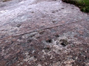
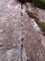
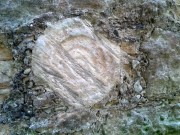
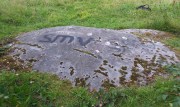
In John MacDonald’s History of Blairgowrie (1899), he describes a number of the prehistoric sites in the neighbourhood, including the cup-marked standing stone at nearby Glenballoch. However, one petroglyph that seems to have escaped the attention of all previous surveys was, “one unearthed in 1897 at Aikenhead,” southeast of Blairgowrie.  Mr MacDonald described it as possessing “a large number” of cup markings “of various sizes.” But even in his day he reported that the carving had, “unfortunately, been destroyed.”

I can find no other references to this site.  Is anyone aware of any, or know anything more about this lost stone?

References:

  1.  MacDonald, John A.R., The History of Blairgowrie, Advertiser: Blairgowrie 1899.

© Paul BennettThe Northern Antiquarian

The map could not be loaded. Please contact the site owner.


Glesart Stanes, Glassford, Lanarkshire

Standing Stones:  OS Grid Reference – NS 73609 46916

Also Known as:

  1. Avonholm
  2. Canmore ID 45595
  3. Glesart Stones
  4. Struthers Burial Ground
  5. Three Stones

Getting Here

Glesart Stones on 1864 map

From the roundabout in Glassford village, head west down Jackson Street along the country lane of Hunterlees Road.  About 600 yards on, turn right at the small crossroads (passing the cemetery on yer left) for about half-a-mile, before turning left along a small track that head to some trees 400 yards along.  Once you’ve reached the trees, walk uphill and follow the footpath to the right, keeping to the tree-line.  It eventually runs to a small private graveyard. You’re there!

Archaeology & History
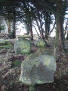
Glesart Stones,
looking west

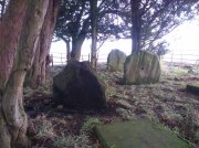
In the little-known private graveyard of the Struthers family on the crest of the ridge overlooking the River Avon and gazing across landscape stretching for miles into the distance, nearly a mile east of Glassford village, several hundred yards away from the Commonwealth graveyard, a cluster of yew trees hides, not only the 19th century tombstones, but remnants of some thing much more archaic.  Three small standing stones, between 2½ and 4 feet in height, hide unseen under cover of the yews, at the end of a much overgrown ancient trackway which terminates at the site.  They’re odd, inasmuch as they don’t seem to be in their original position.  Yet some form of archaic veracity seems confirmed by the weathered fluting: eroded lines stretching down the faces of two of the taller stones and, more importantly, what seem to be cup-markings on each of the monoliths.
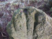
Cup-mark atop of east stone
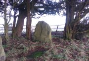
Easternmost stone

The tallest stone at the eastern end of the graveyard has a deep cup on its crown.  This may be the result of weathering; but we must exercise caution with our scepticism here.  Certainly the eroded lines that run down this stone are due to weathering – and many centuries of it; but the peculiarity is that the weathering occurs only on one side.  This implies that only one side of the stone was open to the elements.
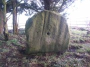
Central cup-marked stone
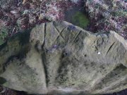
‘X’ carved atop of central stone

The second, central stone of the three, is slightly smaller than the first.  Unlike the eastern stone, its crown has been snapped off at some time in the past century or so, as evidenced in the flat smooth top.  But along the top are a series of small incised marks, one of which includes a notable ‘X’, which may have been surrounded by a circle.  A second fainter ‘X’ can be seen to its side, and small metal-cut lines are at each side of these figures.  Another small section of this stone on its southern edge has also been snapped off at some time in the past.  The most notable element on this monolith is the reasonably large cup-mark on its central west-face.  It is distinctly eroded, measuring 2-3 inches across and an inch or more deep.  Its nature and form is just like the one in the middle of the tallest of the standing stones at Tuilyies, nearly 31 miles to the northeast.
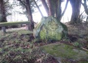
Western smallest stone
The Three Stones

The smallest of the three stones is just a few feet away from the central stone.  To me, it seemed oddly-placed (not sure why) and had seen the attention of a fire at its base not too long ago.  On its vertical face near the top-centre of the stone, another cup-marking seems in evidence, some 2 inches across and half-an-inch deep—but this may be natural.  The Glasgow archaeologist Kenneth Brophy reported that on a recent visit, computer photogrammetry was undertaken here, so we’ll hopefully see what they found soon enough.

There is some degree of caution amongst some archaeologists regarding the prehistoric authenticity of the Glesart Stanes – and not without good cause.  Yet despite this, the seeming cup-marks and, particularly, the positioning of the stones in the landscape suggest something ancient this way stood.  The stones here are more likely to be the remains of a once-larger monument: perhaps a cairn; perhaps a ring of stones; or perhaps even an early christian site.  At the bottom of the hill for example, just 350 yards below, is a large curve in the River Avon on the other side of which we find the remains of an early church dedicated to that heathen figure of St. Ninian (his holy well close by); and 300 yards north is the wooded Priest’s Burn, whose history and folklore seem lost.

The Glesart Stanes were the subject of an extended article by M.T. M’Whirter in the Hamilton Advertiser in 1929 (for which I must thank Ewan Allinson for putting it on-line).  He wrote:

“Situated on the highest hill-top on the estate of Avonholm, north to the house of that name, is the private burial ground of James Young Struthers… Situated within the burial ground are three upright flagstones of a dark brown colour, rough and unhewn,  Each stone is facing the east, and placed one behind the other, though not in a straight line, and the space between the eastern and the middle stone is eight feet, and the space between the middle and the western stone is seven feet.  The stone flags vary in measurement, the eastern stone being the greater, standing four feet three inches high, three feet eight inches broad, and one foot thick.  The middle stone is three feet high, three feet ten inches broad, and nine inches thick; and the western stone is three feet high, four feet broad and ten inches thick.  The two outer stones bear no letters, figures or marks, but the centre stone has rudely sculptured on the top-edge the Roman numerals IX, and on the western side of the stone there is a cup-shaped indentation about two inches in diameter.  A groove 26 inches in length extends from the top of the stone to below the level of the cup indentation.  The groove is deeper at the top, but gradually loses in depth towards the bottom end.  I have seen grooves similar to above by the friction of a wire rope passing over a rocky surface.  The numerals, cup indentation and groove do not appear to be part of the original placing of the stones and, if a cromlech, then in the centuries that have gone, the stones becoming exposed to view by the removal of the mound, would invariably have led to a search for stone coffins or urns, yet no discovery of either has ever been recorded.”

Indeed, Mr M’Whirter was sceptical of them being part of a prehistoric burial site, preferring instead to think that a megalithic ring once stood here.  He continued:

“From an examination of the three stones, I am convinced that they form a segment of a circle, and assuming that nine additional stones complete the circle, it would enclose a space of roughly one hundred feet in circumference, with each stone facing an easterly direction.”

But we might never know for certain…. The only other literary source I have come across which describes the site is that by the local vicar, William Stewart (1988), who told us that:

“The stones stand erect, six feet apart, three rough slabs of coarse-grained sandstone, three feet high, three feet broad and six inches thick, free of any chisel marks.  Two have their back to the east, the third, oblique to the others, has its back to the south-east, thus there is no suggestion of a stone circle.  There are vertical grooves on two of the stones, while the centre stone has a cupmark, below which is a faint circle, one foot in diameter.  They stand at the end of a long narrow strip of land with low earthen walls on either side, perhaps an old agricultural field division, and they gave their name ‘Three Stanes’, to a now partly-lost road which eventually reached The Craggs and ended as Threestanes Road in Strathaven…”

The Three Stones

The “faint circle” described by Mr Stewart is barely visible now.  And the idea that these “three stones” gave their name to the farmhouse and road of the same name at the other side of Strathaven, three miles west, seems to be stretching credulity to the limits.  Surely?

Folklore

In 1845, Gavin Laing in the New Statistical Account for Lanarkshire told that:

“These stones are known simply as the “Three Stones”. There is a tradition in the neighbourhood that three Lords were buried here, after being killed while looking on at a Battle. The stones are about 3½ feet high and about as thick as flag stones. They stand upright being firmly fixed in the ground.”

The stones and their traditional origin were also mentioned in Francis Groome’s Ordnance Gazetteer (1884), where he echoed the 1845 NSA account, but also added:

“Three tall upright stones are here, and have been variously regarded as Caledonian remains, as monuments of ancient noblemen, and as monuments of martyrs.”

Then at the end of the 1850s, when the Ordnance Survey lads came here, they reported,

“Three high stones stand upright on a small eminence upon the lands of Avonholm, respecting their origin there are various opinions. They are probably the remnants of Druidical superstition.”

References:

  1. Groome, Francis H., Ordnance Gazetteer of Scotland – volume 1, Thomas C. Jack: Edinburgh 1884.
  2. M’Whirter, M.T., “The Standing Stones at Glassford,” in Hamilton Advertiser, 1929.
  3. Stewart, William T., Glasford – The Kirk and the Kingdom, Mainsprint: Hamilton 1988.
  4. Wilson, James Alexander, A Contribution to the History of Lanarkshire – volume 2, J. Wylie: Glasgow 1937.

© Paul BennettThe Northern Antiquarian

The map could not be loaded. Please contact the site owner.

Langside House, Cathcart, Glasgow, Lanarkshire

Cup-and-Ring Stone (removed):  OS Grid Reference – NS 5726 6128

Also Known as:

  1. Bluebell Woods
  2. Canmore ID 44291
  3. Langside Stone

Archaeology & History

In a region where, today, the busy city spreads its urban tendrils on the south-side of Glasgow, there could once be found an excellent multi-ringed prehistoric petroglyph.  It was located in the landscape of Langside and Battlefield, betwixt where now large houses grow, a few hundred yards south of the hillfort-topped Queen’s Park. According to the official records, it was all alone – but I don’t buy that for one minute! (petroglyphs rarely occur in isolation)

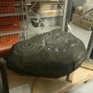
The carving in Kelvin Hall, Glasgow (photo by Donny McIntyre)
Langside House carving

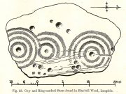
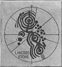
Before being noticed by archaeologists, the stone was apparently being used as a stone seat in the woods on which people would sit, rest and admire the view!  It was probably a part of a larger monument, perhaps a cairn of some sort.  As we can see in the sketches that were made of it, along with Donny’s photo of it (right) in the Glasgow Museum store-rooms, the stone was part of a larger piece and was likely to have had companions, but records seem to be silent on the matter.  The most detailed description of it comes from the pen of northern antiquarian Fred Coles (1906), who gave us the following literary portrait:

“The first notice of the Stone incised with the design shown below was due to Mr W. A. Donnelly, who contributed a description and a sketch to The Glasgow Evening Times of 25th June 1902.  Later, Mr Ludovic Mann, at my request, sent me certain notes he had taken of the cup-and-ring-marks.  But prior to this, the Stone itself had, on the instigation of Mr Donnelly, I think, been removed from its site in the wood, and placed near one of the entrances to the new Kelvinside Museum.  There I saw it and made measurements in July 1903.

“The Bluebell Wood lies in a curving line to the west and south of Langside House, and the cup-marked Stone was at a point in the southern extremity of the wood, above and north of the river Cart.  It is interesting to be able also to record that the longer axis of the Stone lay almost precisely north and South, and the opposite axis east and west.*  The Stone is of a hard, whitish sandstone, a good deal weathered and rounded at the edges. It measures 4 feet 9 inches in length and 3 feet 2 inches in breadth, and varies in thickness from 2 feet 6 inches to 1 foot 7 inches.  The striation of the Stone has helped to efface the cuttings which, though perfectly clear and measurable, are shallow in proportion to their width.  And this feature I have endeavoured to portray in the accompanying illustration (above).  Beginning at the north end of the Stone, there is one cup placed just where the outermost ring of that group touches the edge of the Stone.  The ring has a groove leading towards but not into a central cup, and four other cups are placed on the two outermost rings, there being four rings in this group.  The middle group consists of a central cup and three rings, flanked on the west by a row of three cups (one of which is the largest of all), and on the east by a double row of six cups, three of which are almost obliterated.  This middle group is imperfectly concentric, two of its arcs running into the fourth ring of the group on the south, which has a fine deeply picked central cup.  All the better-preserved rings are very nearly 1½ inches in width of cutting.

“The diameters of the outermost rings in each group are: of the north group, 1 foot 9 inches; of the middle group 1 foot 5 inches; and of the south group 1 foot 7 inches.  The cups vary in diameter from 3 inches to 1½.

“Considering the extremely easily weathered nature of this Stone, and the fact that its sculptured surface has already suffered much ill-usage, its present position, near the entrance of the Art Galleries, entirely unprotected by a railing and exposed to all sorts of abuse by casual passers-by as well as the weather, is not a fit and proper place for a Stone of such interest.”

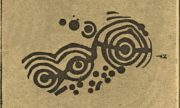
A few years after this, the local historian Ludovic MacLellan Mann (1930) wrote a piece for the Glasgow Herald, in which he thought that both this and another carving in the area,

“commemorate chiefly…an eclipse of the sun seen in Glasgow district in the year 2983 BC, at three o’ clock in the afternoon of the sixth day after the Spring Equinox.”

Mann’s 1930 sketch

A fascinating idea…  Mann was intrigued by the theory that petroglyphs represented astronomical events or maps of the skies – and we know from cultures elsewhere in the world that some carvings had such a function; but it’s not integral to all carvings by any means.

The stone was included in Ron Morris’ (1981) survey, merely echoing the description of Fred Coles, adding nothing more.  And so it seems that the carving is still in the museum somewhere.  Canmore has it listed as “Accession no: 02-78”.  Does anyone know of its present situation?  Can anyone get a photo so we can give it a more fitting site profile?  It looked a damn good carving!  And, if anyone lives nearby, I note that there are small patches of the old woodland still visible on GoogleEarth: therein, perhaps, a diligent explorer may just find another carving….

References:

  1. Coles, Fred, “Notices of Standing Stones, Cists and Hitherto Unrecorded Cup-and-Ring Marks in Various Localities,” in Proceedings of the Society of Antiquaries, Scotland, volume 40, Edinburgh 1906.
  2. Donnelly, W.A., “Letter”, Glasgow Evening Times, 25 June, 1902.
  3. Mann, Ludovic MacLellan, “The Eclipse in 2983 B.C. – Discovery near Glasgow,” in Glasgow Herald, 17.09.1930.
  4. Morris, Ronald W.B., “The Cup-and-Ring Marks and Similar Sculptures of South-West Scotland,” in Transactions of the Ancient Monuments Society, volume 14, 1967.
  5. Morris, Ronald W.B., The Prehistoric Rock Art of Southern Scotland, BAR: Oxford 1981.
  6. Morris, Ronald W.B. & Bailey, Douglas C., “The Cup-and-Ring Marks and Similar Sculptures of Southwestern Scotland: A Survey,” in Proceedings of the Society of Antiquaries, Scotland, volume 98, 1966.
  7. Small, Sam, Greater Glasgow: An Illustrated Architectural Guide, RIAS: Edinburgh 2008.

ACKNOWLEDGEMENTS:  Huge thanks to beautiful Aisha for putting me up; and to Donny McIntyre for letting us use his photo.

* Although Coles did note how its earlier use as a stone seat probably negates his axial measurements.

© Paul BennettThe Northern Antiquarian

The map could not be loaded. Please contact the site owner.


High Banks (03), Kirkcudbright, Kirkcudbrightshire

Cup-and-Ring Stone (lost):  OS Grid Reference – NX 709 489

Archaeology & History

One of the lost High Banks carvings

One of the lost High Banks carvings

The drawing here is another by the legendary Fred Coles, previously unpublished until Maarten van Hoek (1990) brought it out of the dusty archives of the Stewartry Museum, Kirkcudbright, and described it in his article on prehistoric rosette motifs.  As with its fellow carving of High Banks 2, the location of the site remains unknown; and van Hoek wondered whether these two lost carvings “could have been located at the spot where now the little quarry at High Banks site is found.”  Let’s hope not!

References:

  1. Morris, Ronald W.B., The Prehistoric Rock Art of Galloway and the Isle of Man, Blandford: Poole 1979.
  2. van Hoek, M.A.M., “The Rosette in British and Irish Rock Art,” in Glasgow Archaeological Journal, volume 16, 1990.

© Paul BennettThe Northern Antiquarian

The map could not be loaded. Please contact the site owner.


High Banks (02), Kirkcudbright, Kirkcudbrightshire

Cup-and-Ring Stone (lost):  OS Grid Reference – NX 709 489

Archaeology & History

One of the lost High Banks carvings

One of the lost High Banks carvings

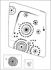
This impressive carving was found somewhere in the vicinity of the well-known High Banks (01) cup-and-ring menagerie, with its clustered mass of cups and multiple rings.  And the carving we see here possesses something of a similarity with its complex neighbour—but it remains lost.

The drawing was done by our old Scottish megalithomaniac Fred Coles, who discovered the carving when he visited the area around the beginning of the 20th century.  It remained unpublished until fellow rock art student Maarten van Hoek (1990) explored the region and found it hiding away in the archives at the Stewartry Museum, Kirkcudbright.  The multiple rings of cups surrounding central cups and cup-and-rings are very rare things indeed and this carving is utterly unique in the British Isles.

In Coles’ drawing, as well as the large carving, we have two other elements below, boxed.  These are taken from a notebook found in the same Stewartry Museum and thought to have been done by a Mr G. Hamilton around 1866.  In the lower-box, the double-ringed cup with its surround of two more rings of cup-marks was suggested at first by van Hoek (1990) to possibly be the same carving as that found by Coles.  But he questioned this, sensibly, as the carved design ‘B’,

“comprises 35 cups (its diameter stated to be 21 inches / 51cm), whereas Coles’ diagram of ‘A’ shows only 24 outer cups.  The unknown artist moreover says that, ‘The above (B) is one of a splendid group on Banks Farm.’  So this rosette (B) might be a completely different specimen altogether.”

I have to agree with him.  In the second smaller box, ‘C’, the drawing of the cluster of cup-marks is taken from the same 19th century notebook in which the author said there was a cluster of

“70 to 100 small cups without any apparent system, except being in a group of 7 with cup in the centre—also 3 or 4 circles.”

No other details were given.  Petroglyph explorers in the area should keep their senses peeled when meandering about here, for this and other missing carvings (High Banks 3).

References:

  1. Morris, Ronald W.B., The Prehistoric Rock Art of Galloway and the Isle of Man, Blandford: Poole 1979.
  2. van Hoek, M.A.M., “The Rosette in British and Irish Rock Art,” in Glasgow Archaeological Journal, volume 16, 1990.

© Paul BennettThe Northern Antiquarian

The map could not be loaded. Please contact the site owner.


West Strathan Carving, Melness, Sutherland

Cup-and-Ring Stone: OS Grid Reference – NC 56428 64071

Getting Here

West Strathan Petroglyph

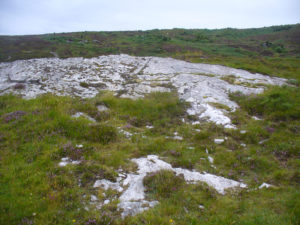
Along the A836 road between Durness and Tongue, take the minor road north to Melness. Keeping to the right all the way along, drive almost to the very end, shortly before which is a double right-hand bend uphill. Park here and walk back along the road, north, past the cottage of Dun Bhuidhe for about 100 yards until you see the large sloping rock face with the telegraph post sticking out of it. That’s the place!

Archaeology & History

Not previously recorded, this cup-and-ring stone is right by the roadside up the far, lonely but beautiful glen west of Melness, which runs to a dead-end and into the heart of the silent moors high up in Sutherland’s remote landscape — and it’s a damn good one!  It’s also the most northern example known of a Neolithic or Bronze Age petroglyph on the British mainland.   The carving has been etched onto a large easterly sloping rock, fractured into several sections, with the decayed broch of Dun Bhuidhe rising to its immediate southwest. The setting alone is outstanding!

Sketch of the carving
3 cups on the lower-east side

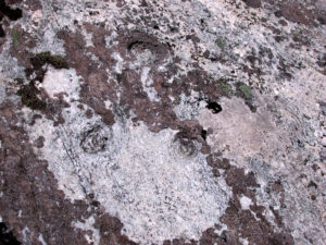
It was rediscovered on 25 August, 2015, after Prof Hornby and I had analysed the chambered tomb south of Dalvaid about half-a-mile away. In walking back to explore the aforementioned broch, I cut across the bottom of a nearby rock and found three distinct cup-markings etched near the bottom of its sloping face. Calling out to Prof Hornby, he retreated in his direction to the broch and came back to look at the top of this very large rock surface.

“There are some more cups on this section of the stone!” he called – and began to count them. “At least ten in this little section,” he said. There were indeed!

Carving, looking west

Carving, looking west

Carving, looking south

Carving, looking south

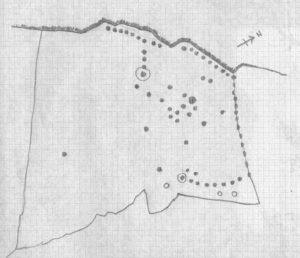
By the time we’d finished counting, drawing and assessing the design etched onto the rock surface, amongst at least two cup-and-ring elements we found at least 67 cup-markings, mainly carved onto the northwest portion of the stone. The first three that I’d seen were on the much lower eastern part and were etched in deliberate isolation from the primary design.  However, of these three isolated cups, it looks as if one of them may have a spiral element curving out of it. This needs assessing in much better lighting conditions, because when we found it the skies were very grey and overcast, making an accurate survey very difficult (cup-marks on rocks can be hard to see unless daylight conditions are just right) – and, after a short while, the legendary Scottish midges appeared and began to feast on us, which stopped us in our work. The little buggers!

On a subsequent visit here with Sarah MacLean of Borgie in the summer of 2018, she found several more cup-marks beneath the lower arc shown in the above drawing (which I need to update, obviously).

Central features of the carving

Central features of the carving

Scatter of central cups

Scatter of central cups

The most notable feature to this carving is the arrangement of the great majority of the cup markings. They were quite deliberately carved along the very top of the stone, close to its edge, in two contiguous lines of nine with a small gap separating them. At the northwestern end of this, a very notable feature occurs: a natural crack in the rock runs down the stone and, almost all the way down, we find a line of cups have been pecked onto the stone along the natural crack, with some of them near the top that are unfinished. These cup-marks are more elongated in form than the usual circular status; but this is due to them being etched into the cleft itself. From top to bottom there are 13 such cups. At the bottom of this line, another linear stretch of cups change direction and move back onto the main rock surface, just above another large long natural crack cutting across the rock.  This gentle arc of cups (with two other possible cups beneath these) ends at a cup-and-ring, above which are two extra cups next to each other. Above these are a number of other cups of roughly similar size and depth, with a notably large one that gives the impression that the smaller cups around its edges are satellites to its larger parent body.

Line of cups on western edge

Line of cups on western edge

Row of cups etched into natural crack

Row of cups etched into natural crack

Without any doubt there are other faint features that have been carved onto the stone, but due to the poor visibility factor at the time of its discovery we could not see anything other than the elements highlighted in the rough sketch.  In looking through the many photos we took of this carving, there seem to be other faint lines, rings and cups within the overall design, but until we revisit the site (or someone else does!) such further features cannot be added to the drawing.

As the images of this petroglyph clearly shows, the primary feature defining it is the extensive line of continuous cup-markings running along the edges and enclosing a smaller number of internal cups. It’s an unusual element. Sequential line features such as these, defined by cups, are not common. My impression of this feature is that it was a pictorial representation of the horizons, inside which is played the story of….. something… But horizons they seem. Of course, this is a simplistic interpretation and is open to criticisms of any form. I care not!  Much more importantly as far as I’m concerned is the fact that we’ve uncovered yet another unrecorded carving – and according to the official records, no such carvings exist here; but where one such carving exists, others are close by!

Watch this space…..

Acknowledgements: Considerable thanks must be given to Prof Paul Hornby, for use of his photos and without whose help this carving might never have been located. Cheers dood!

© Paul BennettThe Northern Antiquarian

The map could not be loaded. Please contact the site owner.


Raith Gardens, Kirkcaldy, Fife

Cup-and-Ring Stone:  OS Grid Reference – NT 27131 91374

Getting Here

The multiple-ringed petroglyph of Raith, Kirkcaldy

The multiple-ringed petroglyph of Raith, Kirkcaldy

On the more south-side of Kirkcaldy, head for the roundabout at the meeting of the A910, B925 and B9157, heading out west along the Auchtertool road; but just 60-70 yards past the roundabout, take the first right along Raith Drive.  Wibble along here for a few hundred yards until you reach Raith Gardens.  Walk down here for 50 yards and cross onto to the grasses opposite where a path runs parallel with a large old stone wall.  Barely 2 feet above ground level, keep yer eyes on the walling!

Archaeology & History

Close-up of the carving

Close-up of the carving

This is a peculiar one.  A very peculiar one!  Found embedded in some very old walling, it is similar in size, style and design to the curiously un-eroded multiple-ringed Binn-1 petroglyph 3.9 miles (6.2km) southwest, this concentric four-ringed ‘cup-and-ring’ stone actually seems to have no central cup.  That aint too unusual.  But the oddity here is its complete isolation—not merely from any other petroglyphs, but from any other neolithic or Bronze Age site.

The concentric rings are incomplete on the outer two rings, with openings or gateways to the inner two rings (a common element).  Several parallel scars are clearly visible that have been cut across the surface of the stone, affecting the clarity of the carving.  Whether these scars are geophysical, or were caused when the carving was moved and fit into the wall, we do not know.

The stone may or may not have been a portable one, typical of those attached to cairns or tomb-covers; or it may have been broken from a large piece of rock.  We just don’t know.  The design is typical of those found in relation to prehistoric tombs, yet none are known to have been here.  In 1872 The Antiquary Journal covered the story of four stone coffins being found when the first Co-op building was being built in Kirkcaldy, on top of which was “an earthen urn” – but where was that exactly?  Did the carving come from there?  We do know that the walling in which the carving has been fixed was once part of an old Abbot’s Hall – but whatever was here before that, history seems to have forgotten.

A fascinating little mystery this one…..

Acknowledgements:  Huge thanks to Penny Sinclair for showing us to this little-known site. Cheers Pen. 🙂

© Paul BennettThe Northern Antiquarian

The map could not be loaded. Please contact the site owner.


The Binn (01), Burntisland, Fife

Cup-and-Ring Stone:  OS Grid Reference – NT 22741 86948

Also Known as:

  1. Binn House
  2. Canmore ID 269301
  3. Craigkelly 
  4. Silverbarton Farm

Getting Here

The Binn1-2

Penny pointing the way

From Burntisland, go up the Cowdenbeath road for just over half-a-mile, then turn right and walk into the woods up the footpath.  Go uphill, over the first stile until you reach the field less than 200 yards above.  Follow the line of the trees, right, along the edge of the field for about 100 yards, then walk uphill into the trees again until you reach a small rocky outcrop.  That’s the spot!

Archaeology & History

Rediscovered in the summer of 2003, this is one in a small cluster of little-known petroglyphs on the western slopes of the hill known as The Binn.  Found less than a yard away from another carving, this ornate-looking fella consists of a wide cup-mark with three very well-defined concentric rings around it.  A carved line runs out from the central cup, down the gentle slope of the rock and out of the rings entirely; whilst 60° left of this line, a second one runs from the central cup to the inner edge of the third concentric ring. To the left of the 3-rings is another concentric system, with one clear ring around a faint shallow inner-cup and what seems to be a faint outer secondary ring.  A possible third isolated cup-mark is to the top-left of the multiple rings.

The carving under the overhang

The carving under the overhang

Close-up of the multiple rings

Close-up of the multiple rings

This is one of two carvings that are right next to each other and it is curious inasmuch as the erosion on it seems negligible.  This may be due to the overhanging rock which shelters it considerably from normal weathering processes.  Indeed, if the carving was uncovered from beneath a covering layer soil, the lack of erosion on it makes complete sense.  However, I have to say that I was slightly skeptical about assigning any great age to this particular design—and until we get an assessment from a reputable geologist we should perhaps be cautious about giving it a definite prehistoric provenance.  It’s still very much worth seeing though.  The carving on the adjacent rock however, is a different kettle o’ fish altogether!

Acknowledgements:  Huge thanks to Penny Sinclair for guiding us to this little-known site. Cheers Pen. 🙂

© Paul BennettThe Northern Antiquarian

The map could not be loaded. Please contact the site owner.


Cochno (05), Duntocher, Dumbartonshire

Cup-Marked Stone:  OS Grid Reference – NS 50301 73655

Also Known as:

  1. Auchnacraig
  2. Canmore ID 44536

Getting Here

The sprayed Cochno-5 stone

The sprayed Cochno-5 stone

Along the A810 Bearsden to Dunochter road, 100 yards past the Faifley roundabout, turn right up Cochno Road. Go up for literally 1 mile and hit the car-park.  Go back onto the road and walk uphill.  Barely 50 yards up, turn right and walk down the track.  About 350 yards along its bendy route, some grasslands appear on your right and there, about 40 yards away, is the large Cochno-5 carving.

Archaeology & History

First described by James Harvey (1889) in association with adjacent carvings, he told that “there are eight isolated cups, two of which have a diameter of 2½ inches” on this stone.  Harvey was one of those who loved the idea that our ancestors were etching cup-marks as receptacles for collecting blood and similar christian fantasies. It was a bittova fad at the time.

Close-up of topmost cupmarks

Close-up of topmost cupmarks

The sprayed Cochno-5 stone

James Harvey’s 1889 sketch

As we can see, the kids have sprayed their own ID onto the stone.  It’s highly unlikely that they were even aware of this being a prehistoric site as there’s nothing to indicate it as such, and I know of archaeologists who wouldn’t have even seen the cup-marks on the stone, so we can’t really apportion blame. (We must recall that businessman Tom Lonsdale and Ilkley Council branded such things as “twenty-first century informal unauthorised carvings” when they sought and succeeded to get large amounts of cash to justify their own ‘brand’ of vandalism and called it ‘art’.  Very common amongst those social types.)

References:

  1. Harvey, James, “Notes on Some Undescribed Cup-Marked Rocks at Duntocher, Dumbartonshire”, in Proceedings Society Antiquaries, Scotland, volume 23, 1889.

Acknowledgements:  Huge thanks to the awesome Aisha Domleo and her little dynamic duo for helping us get to this site.

© Paul BennettThe Northern Antiquarian 

The map could not be loaded. Please contact the site owner.


Coilsfield, Tarbolton, Ayrshire

Cup-and-Ring Stone (lost):  OS Grid Reference – NS 4469 2624

Also Known as:

  1. Canmore ID 42713
  2. King Coil’s Grave Stone
  3. Old King Cole’s Stone (Morris 1981)

Archaeology & History

Daniel Wilson's 1851 sketch of the carving

Daniel Wilson’s 1851 sketch of the carving

This fascinating and very ornate prehistoric carving was found on the underside of a grave-slab beneath Old King Coil’s Grave, or an adjacent prehistoric burial feature (we don’t know for sure).  In Daniel Wilson’s (1851) superb early work on prehistoric Scotland is a detailed drawing of this ornate petroglyph—similar in design and form to those found across the waters in Ireland—copied “from a drawing presented to the Royal Society of Edinburgh by Colonel Hugh Montgomery of Shielmorly, in 1785.”  Mr Wilson informed us that,

“It formed the cover of a cist, discovered in digging a gravel-pit at Coilsfield, in Ayrshire, and underneath it was found an urn filled with incinerated bones. The dimensions of the stone were about five feet in length by two and a half feet in breadth”

James Simpson's 1866 sketch

James Simpson’s 1866 sketch

A few years later Sir James Simpson (1866; 1867) wrote and published the earliest (and still one of the finest) books on aboriginal rock carvings in the British Isles, and all but echoed what Wilson had described.  He added a further description of the designs that were carved onto the stone, telling us that,

“it had cut upon it a series of concentric circles, consisting of six rings placed around a central cup, the rings traversed by a straight radial groove.  On the drawing are marks of other cups and rings, or rather volutes, and a number of angular lines… This sculptured stone covered an urn…”

Following the descriptions of our early authors, many archaeologists and antiquarians explored the site but could find little else about the carving.  In Ron Morris’ (1981) most recent survey, he told us that it was,

“a gritstone slab, 1½m by ¾m (5ft x 2½ft), possibly broken after carving, had on one side (not now known if this was the inner of outer face); a cup-and-six-complete-rings with radial groove from the cup – diameter 50cm (20in) – 5 other cups-and-rings, mostly partly broken off or incomplete, an irregular ‘reversed-S-shaped’ single spiral with 3 convolutions at each end, other irregular grooved figures, 4 cups and about 7 ‘dots’ (6 of these are in the cup-and-six-rings).”

The Royal Commission at Canmore tell us that “the present location of the food vessel and cist cover is unknown”; yet the rock art researcher Ronald W.B. Morris (1981) reported the petroglyph was “said to have been given to the Society of Antiquaries of Scotland but (is) now missing”; whilst the local writer E.H. Letham (1900) told us “the urns were conveyed to Eglintoun Castle.”  This aint good.  Has anyone subsequently found out what became of it?

Folklore

The tumulus of King Coil’s Grave was the legendary resting place of the “Old King Cole” of popular rhymes.  There were two such northern kings in ancient times and, as William Robertson (1889) said, “the only difficulty is to say which of the King Coils he was, whether the Coilu who lived three hundred and thirty years before Christ; or Coel, King of the Roman districts, who must have lived in the third century.”

References:

  1. Letham, E.H., Burns and Tarbolton, D.Brown: Kilmarnock 1900.
  2. Morris, Ronald W.B., The Prehistoric Rock Art of Southern Scotland, BAR: Oxford 1981.
  3. Morris, Ronald W.B. & Bailey, Douglas C., “The Cup-and-Ring Marks and Similar Sculptures of Southwestern Scotland: A Survey,” in Proceedings of the Society of Antiquaries, Scotland, volume 98, 1966.
  4. Morrison, Alex, The Bronze Age in Ayrshire, Ayrshire Natural History & Archaeology Society 1978.
  5. Robertson, William, Historical Tales and Legends of Ayrshire, Thomas D. Morrison: Glasgow 1889.
  6. Paterson, James, History of the County of Ayr – volume 2, Thomas Stevenson: Edinburgh 1852.
  7. Simpson, J.Y., “On Ancient Sculpturings of Cups and Concentric Rings,” in Proceedings of the Society of Antiquaries, Scotland, volume 6, 1866.
  8. Simpson, James, Archaic Sculpturings of Cups, Circles, etc., Upon Stones and Rocks in Scotland, England and other Countries, Edmonston & Douglas: Edinburgh 1867.
  9. Smith, John, Prehistoric Man in Ayrshire, Elliot Stock: London 1895.
  10. Wilson, Daniel, The Archaeology and Prehistoric Annals of Scotland, Sutherland & Knox: Edinburgh 1851.
  11. Young, Alison, “Cup-and-Ring Markings on Creag Ruenshin, with Some Comparative Notes,” in Proceedings of the Society of Antiquaries, Scotland, volume 72, 1937.

© Paul BennettThe Northern Antiquarian 

The map could not be loaded. Please contact the site owner.