Burhill Kiln Allotment (415), Appletreewick, North Yorkshire

Cup-and-Ring Stone:  OS Grid Reference – SE 07792 61829

Also Known as:

  1. Carving no.415 (Boughey & Vickerman)
Burhill’s cup-and-ring stone (image courtesy ‘QDanT’)

Getting Here

Probably the easiest way is to park up at Stump Cross Caverns on the B6265 road, then walk down the road for 200 yards till you reach the track on your left running over the fields in the direction towards Simon’s Seat.  Walk along the track past the Skyreholme Wall carving, where it starts going downhill and, 100 yards before you reach the fork in the tracks, look in the field on your left.  The other route is to go east through Appletreewick village up to and through Skyreholme as far as you can drive, where the dirt-track begins.  Keep going up till you hit the fork in the tracks.  Go left, then thru the first gate you come to and walk up into the second field up where the notable rock stands out.  If you can’t see it at first, look around!

Archaeology & History

Boughey & Vickerman’s plan of the carving

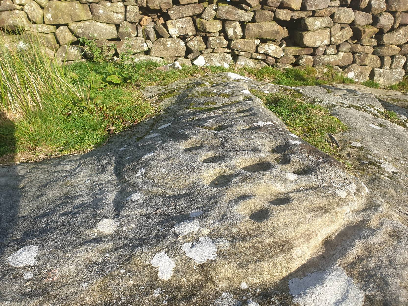
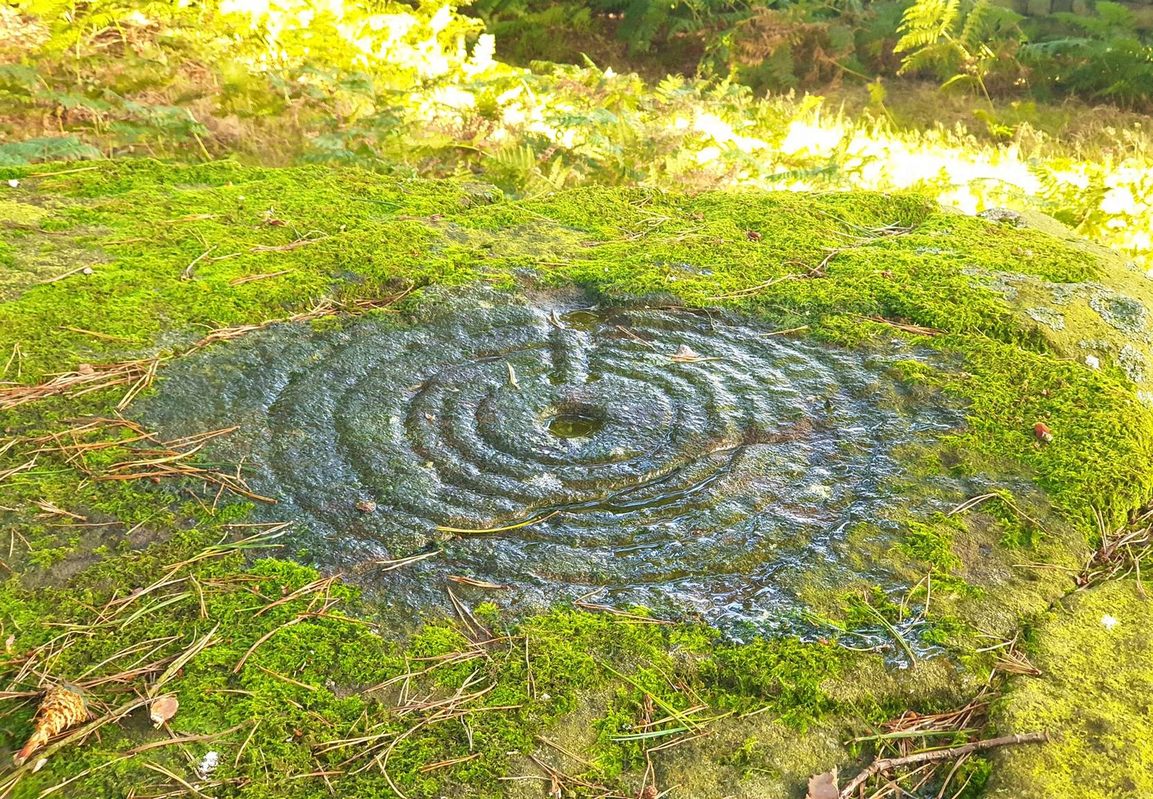
This carving was rediscovered by Stuart Feather (1964) in one of his ambles in the area — and he would have been pretty pleased when he found this one!  It is the most complex and ornate of all the prehistoric carvings in and around this large open field.  With at least nine cup-and-rings and more than fifty other cups etched onto its rounded upper surface, there are various other lines and grooves linking up some elements of this mythic design. The best ones are on the upright and sloping east-face of the rock, into the rising sun.  In animistic terms the rock is distinctly female in nature.

Illustrated in one of Stan Beckensall’s (1999) works, the rock art students Boughey & Vickerman (2003) also include it in their survey, but give an inaccurate grid reference for the site.  They nevertheless describe it as:

“Large upstanding rock with slightly domed top surface. Most of top surface decorated but weathering makes detail uncertain: over sixty cups, eight or more with rings, many grooves.”

Many other carvings can be found in the area.

References:

  1. Beckensall, Stan, British Prehistoric Rock Art, Tempus: Stroud 1999.
  2. Boughey, Keith & Vickerman, E.A., Prehistoric Rock Art of the West Riding, WYAS: Wakefield 2003.
  3. Feather, Stuart, “Appletreewick, W.R.” in ‘The Yorkshire Archaeological Register, 1963’, Yorkshire Archaeological Journal, 41 (part 162), 1964.
  4. Morris, Ronald W.B., “The Prehistoric Rock Art of Great Britain: A Survey of All Sites Bearing Motifs more Complex than Simple Cup-marks,” in Proceedings of the Prehistoric Society, volume 55, 1989.

Acknowledgements:  Huge thanks to the pseudonymous ‘QDanT‘ for use of the photo in this profile.  Cheers Danny!

© Paul Bennett, The Northern Antiquarian

The map could not be loaded. Please contact the site owner.


Burnett’s Ridge (421), Appletreewick, North Yorkshire

Cup-and-Ring Stone:  OS Grid Reference – SE 08103 61500

Also Known as:

  1. Carving no.421 (Boughey & Vickerman)
The beautiful stone… (courtesy ‘QDanT’)

Getting Here

One way is to go east through Appletreewick village up to and through Skyreholme (making sure you bear right at the turn and not go up the left turn, which takes you uphill and elsewhere!) as far as you can drive, where the dirt-track begins.  Keep going up till you hit the fork in the tracks, and here, look into the field on your right.   The other way is to park up at Stump Cross Caverns on the B6265 road, then walk down the road for 200 yards till you reach the track on your left running towards Simon’s Seat.  Walk all the way down this till you reach the fork in the tracks.  There’s a gate into the field just yards below the split in the tracks.  Go thru it and walk into the middle of the field where the stone unmistakably calls out for you to go sit with it for a while!

Archaeology & History

Boughey & Vickerman’s plan of the cup-marks

Sat near a ridge due north of the magnificent Simon’s Seat, this faded carved stone gets its name from the field in which it lives — and as Danny’s photo here shows, it’s a fine stone indeed in a very fine setting.  The cup-marks on its top were first described by Stuart Feather (1964), who found there to be around 20 cup-markings on the top, with some grooves — possibly natural, possibly man-made — linking them together.

However, in the fields north of here are a number of other cup-and-ring carvings, but much of the landscape has been damaged by industrial workings.  It makes you wonder how many there used to be here before the industrialists started digging the land up…

References:

  1. Boughey, Keith & Vickerman, E.A., Prehistoric Rock Art of the West Riding, WYAS: Wakefield 2003.
  2. Feather, Stuart, “Appletreewick, WR,” in Archaeological Register, Yorkshire Archaeological Journal, volume 41, 1964.
  3. Morris, Ronald W.B., “The Prehistoric Rock Art of Great Britain: A Survey of All Sites Bearing Motifs more Complex than Simple Cup-Marks,” in Proceedings of the Prehistoric Society, volume 55, 1989.

Acknowledgements:

Huge thanks to the pseudonymous ‘QDanT‘ for use of the photo in this profile.  Cheers Danny!

© Paul Bennett, The Northern Antiquarian

The map could not be loaded. Please contact the site owner.


Corrycharmaig 3, Glen Lochay, Killin, Perthshire

Cup-Marked Stone:  OS Grid Reference – NN 52774 35504

Also Known as:

  1. Allt Coire Charmaig

Getting Here

Corrycharmaig 3 stone, with Meall Dhuin Croisg rising…

Go thru Killin and, just past the Bridge of Lochay hotel, take the tiny road on your left.  Go down here for 3 miles till you pass the gorgeous Stag Cottage (with its superb cup-and-rings in the field across the road) for another 300 yards, until you see Duncroisk Farmhouse set back on your right.  On the other side of the road, go thru the giant deer-gates (close ’em behind you) to the river-bridge and across it.  Walk along the track till you reach the turning to Corrycharmaig House on the right (over the stream), but here, go up into the field thru the gate.  Walk up the hill ahead of you with its trees on the left, walking up onto the grassy level, then up again to the rounded knoll another 100 yards up.  You’re here!

Archaeology & History

This is the most visually impressive of the set of four cup-marked rocks along this ridge — although if you visit here when the light is poor, or the sky’s overcast, you’ll be lucky if you can actually see much of the material.  For example, I counted 38 cups on this particular stone on a day when the sky was bright, but upon checking later, found that Mr Morris (1981) described there being, “40 widely scattered cups of which, however, 29 well-defined cups are in a compact group of which 6 are in line.”  Whereas more recently the Canmore website told there to be,

Corrycharmaig-3 carving
Close-up of line of cups

“At least 48 cupmarks are visible on the most westerly exposure. The cupmarks range in size from 25mm in diameter and 5mm in depth to 100mm in diameter and 40mm in depth.  A straight line of six cupmarks arranged close together is orientated running from NW to SE.”

This line of six cups is very distinct and stands out as the most notable aspect on this carving, probably because it gives a sense of ‘order’ or linearity, whereas the rest of the carving (as with oh so many of them, thankfully) possess that non-linear feature of scattered cups and lines, dissolving reason and ego, and eliciting the natural meditative state, if one so cares to allow. On our most recent visit here, our eyes and fingers traced what appeared to be the faint remains of a carved line running along the bottom edge of the row of cups and then bending around the bottom cup in the same line — a little bit like the carved lines which run around the edges of the row of cups on Ilkley Moor’s Idol Stone.  You can just make this ‘line’ out in the photo, below.

Cup-mark and flint
Clusters of cups and faint line

On our most recent visit to the site when we stayed at Corrycharmaig house below (huge thanks to Sylvana!), other sections of the carving were visible that we’d missed before, highlighting at least 45 cup-marks that we counted.  Several of the cups had been exposed by animals (sheep or deer – we couldn’t tell) cutting into the soaking wet earth and in carefully checking a couple of cups whose edges were exposed, found a small worked flint within one of the cups!  I looked at it, held it, puzzled over it, then laid it back where we’d found it.  You can see it in the photo here, on the right.

This carving obviously grows on you with time.  And like its carved companions of Corrycharmaig 1, 2 and 4 both left and right of here, the stone rests within a natural theatre of dreams, eliciting — if only in a slight way — the non-focal perspective necessary to receive the carvings as its executor knew…

References:

  1. Cormack, E.A., “Cross-Markings and Cup-Markings at Duncroisk, Glen Lochay,” in Proceedings of the Society of Antiquaries, Scotland, volume 84, 1952.
  2. Morris, Ronald W.B., The Prehistoric Rock Art of Southern Scotland, BAR 86: Oxford 1981.
  3. Royal Commission on the Ancient & Historical Monuments of Scotland, Archaeological Sites and Monuments of Stirling District, Central Region, Society of Antiquaries of Scotland 1979.

© Paul Bennett, The Northern Antiquarian

The map could not be loaded. Please contact the site owner.


West Agra Plantation 3, Colsterdale, North Yorkshire

Cup-and-Ring Stone:  OS Grid Reference – SE 14236 81675

Also Known as:

  1. WAP 3a & 3b (Brown & Brown)

Getting Here

West Agra 3 Rock

From Masham take the Fearby Road & go through the village, onwards & past Healey village and less than a mile on where the road forks, bear to the right past and go along the gorgeous little-known vale of Colsterdale.  Less than 2 miles on, walk up the notable track veering to your right that goes diagonally uphill and past the bottom of West Agra farm along the wallside till you reach the gate.  Thru the gate, walk immediately uphill on your right following the walling for a coupla hundred yards until you reach another gate into the field on your right.  You’ll see a cluster of large boulders in the first field, which you need to walk past and look at the large boulder up against the walling in the next field.  You can’t miss it!

Archaeology & History

Photo by Geoff Watson

First mentioned — albeit briefly — in Brown’s (2008) work, this large bedrock stone, covered down its eastern side by a line of drystone walling, has a good scattering of cups and lines, mainly on its central and westerly side.  A cluster of them were etched onto a natural rise near the middle of the rock, which itself has a long circuitous line running around its northern and western sides, which you can just see below centre in the photo (below left).  Altogether on this side of the rock surface there appears to be some 56 cup-marks plus a number of long carved grooves curling in differing directions: some of these appear to have been Nature’s handiwork that were subsequently modified by human hands.  It’s an impressive-looking petroglyph.

Main rock surface
Cluster of cups – by QDanT

If we go over to the other side of the walling, we find more cup-markings.  This discovery led Paul & Barbara Brown (2008) to classify the site as being two separate carved rocks — calling them 3a and 3b — thinking that the much smaller carved area on the other side of the wall, “may have originated from WAP 3a’s quarried southern section.”  On this smaller section we find some 7 cup-markings with possible carved lines running off the edge of the stone and some running roughly parallel to the walling.  Whatever the truth of the Browns’ assertion, this is a fine carving well worth looking at!

References:

  1. Brown, Paul & Barbara, Prehistoric Rock Art in the Northern Dales, Tempus: Stroud 2008.

Links:

  1. Agra Wood Rock Art – more notes & images

Acknowledgements:  For use of their photos, many thanks to Geoff Watson; and QDanT and his Teddy!

© Paul Bennett, The Northern Antiquarian

The map could not be loaded. Please contact the site owner.


West Agra Plantation 2b, Colsterdale, North Yorkshire

Cup-Marked Stone:  OS Grid Reference – SE 14126 81669

Also Known as:

  1. WAP 2b (Brown & Brown)

Getting Here

West Agra Carving 2b

From Masham, take the Fearby Road to the village, keep going on the same road through Healey village and less than a mile on where the road forks, bear to the right past and go along the gorgeous little-known vale of Colsterdale.  It’s bloody beautiful!  Less than 2 miles on, walk up the notable track veering to your right that goes diagonally uphill and past the bottom of West Agra farm along the wallside till you get to the gate.  Thru the gate, follow the wall immediately uphill to the right for a coupla hundred yards until you reach a gate into the field on your right.  The cluster of large boulders in front of you is where you need to be!

Archaeology & History

Cluster of cups on WAP-2b (image by ‘QDanT’)

This carving is to be found on the largest of the boulders in this cluster.  It’s a large scattered cluster of cup-markings and natural bowls all over the rolling surface of the rock.  It was first described in the Browns’ (2008) survey, although as they have given this and one of the adjacent stones incorrect grid-references, it made it troublesome to initially work out which carving was which!  But the photos here certainly lets you know which one I’m describing!  In the event that I’ve got the wrong title for this one, someone lemme know and I’ll remedy the situation!

Brown (2008) describes this design as being “cups some linked by grooves, a rectangular feature and eroded cups and depressions.”  We couldn’t work out any further elements on the stone, but the cloudy conditions when we were here prohibited a decent view of the surface.

References:

  1. Brown, Paul & Barbara, Prehistoric Rock Art in the Northern Dales, Tempus: Stroud 2008.

Links:

  1. Agra Wood Rock Art – more notes & images

© Paul Bennett, The Northern Antiquarian

The map could not be loaded. Please contact the site owner.


West Agra Carving, Colsterdale, North Yorkshire

Cup-Marked Stone:  OS Grid Reference – SE 14069 81627

Getting Here

Cup-marked stone near West Agra

From Masham, take the Fearby Road to the village, keep going on the same road through Healey village and less than a mile on where the road forks, bear to the right past and go along the gorgeous little-known vale of Colsterdale.  It’s bloody beautiful!  Less than 2 miles on, walk up the notable track veering to your right that goes diagonally uphill and past the bottom of West Agra farm along the wallside till you get to the gate.  Thru the gate, follow the wall immediately uphill to the right and, about 100 yards up, watch out for the large flat stone by the side of the footpath.  You can’t really miss it.

Archaeology & History

Initially we thought that this carving was one described in Paul Brown’s work as ‘West Agra Plantation no.1’, but this is clearly a different carved stone.  It is found close to WAP-1 (as he called it), but a few yard further up alongside the footpath by the walling.  With two large bowls on the top of the stone and another at the edge, two average-sized cup-markings are several inches away to the bottom-right of the largest bowl.  What seems to be a carved line runs from one of the cups.  We need to visit this stone again and look at it when there’s better lighting conditions so we can get a more accurate assessment of its nature.

References:

  1. Brown, Paul & Barbara, Prehistoric Rock Art in the Northern Dales, Tempus: Stroud 2008.

Links:

  1. Agra Wood Rock Art – more notes & images

© Paul Bennett, The Northern Antiquarian

The map could not be loaded. Please contact the site owner.


West Agra Plantation 8, Colsterdale, North Yorkshire

Cup-and-Ring Stone:  OS Grid Reference – SE 14250 81756

Also Known as:

  1. WAP 8 (Brown & Brown)

Getting Here

The ‘West Agra 8’ Stone (after ‘QDanT’)

From Masham, head westwards along the country lanes to Fearby village (passing the old cross on the green), through old Healey village (where once stood four stone circles, seemingly destroyed) and onwards to Gollinglith.  From here, keep going up the winding steep lane until you’re at the top where, on the right-hand side of the road, a footpath takes you diagonally northwest over the uphill fields.  When you hit the walling which leads to the woods, follow it up and, once at the corner of the trees, follow the track back eastwards along the wall edge, keeping your eyes peeled when you pass the second line of walling that runs down the slope.  You’re damn close!

Archaeology & History

One of a cluster of fascinating carvings in this remote region of the upland Dales, this is perhaps the most impressive multiple-ringed carving of the group, known collectively as the West Agra Plantation group.  The carving was rediscovered sometime in 2002 by Emily McIntosh and was described by Brown & Brown (2008) thus:

“This boulder measures 5.5 x 3.1 x 1.28m and has a multiringed motif 50cm in diameter linked by a number of grooves and isolated cups.”

Teddy with his rings! (after ‘QDanT’)
Primary cup-and-multiple-rings (after ‘QDanT’)

But this barely does the stone justice.  The main focus is on the cup with six surrounding rings, intersected by an intrusive double-line from outside the series of rings then running into the central ring itself — though not touching the focal cup at the very centre.  This double line points to the southeast and is somewhat akin to a sliver of light running to or from old solar designs.  It is a little bit like some aspects of the carved stones found on Ilkley’s Panorama Stones (though Ilkley’s carvings are much fainter).  At the end of the intrusive double-line is a small cluster of cup-marks.  There’s also another curious singular carved line running outwards from the third ring, running out of the concentric rings then heading off further down the stone.  More cups and lines scatter other parts of the stone and there may be another faint line running from near the central cup all the way out of the rings close to the main ‘ray’ of lines.

Photo by Geoff Watson

A large standing stone can be seen if you walk a few hundred yards east along the side of the wall.  It’s quite impressive.

Apparently the woodland in which this carving (and its associates) can be found is supposedly ‘private’ and one is supposed to contact some group calling itself Swinton Estates to set foot in the woods.  Not the sorta practice we usually put up with in Yorkshire.  If anyone has their contact details, please add them below in the event that anyone has need to ask ’em about going for a walk here.

References:

  1. Brown, Paul & Barbara, Prehistoric Rock Art in the Northern Dales, Tempus: Stroud 2008.

Links:

  1. Agra Wood Rock Art – more notes & images

AcknowledgementsFor use of their photos, many thanks to Geoff Watson; and QDanT and his Teddy!

© Paul Bennett, The Northern Antiquarian

The map could not be loaded. Please contact the site owner.


Solar Stone, Askwith Moor, North Yorkshire

Cup-and-Ring Stone:  OS Grid Reference – SE 17738 51003

Also Known as:

  1. Carving no.567 (Boughey & Vickerman)
  2. TV Stone

Getting Here

Stone at cairn edge

From the scruffy Askwith Moor lay-by car-park, along Askwith Moor road, follow the fence north up along the roadside until you reach the gate on your right.  Go thru this and head due west into the moor, towards the small cluster of other carved stones (carvings 581, 582, etc), particularly the Small Rings Stone (carving 579).  Around here, you’ll notice a cluster of about 10 mounds in the heather, which seem to be prehistoric cairns, and this particular stone rest against the northwestern side of one of them, about 30 yards west of carving 579.  If you’re patient, you’ll find it! (if you fancy a look at all these on the moor, gimme a shout & I’ll take you straight to ’em – but you need to make a booking!)

Archaeology & History

This carving takes a bitta finding amidst the mass of deep heather and open moorland and is probably only gonna be of interest to real cup-and-ring fanatics.  But it’s the setting which makes it more intriguing — for me anyhow!

Trying to highlight the internal CnR
Solar Stone carving

Like other carvings on this moorland, we find it in direct association with a prehistoric tomb (though it aint been excavated), resting up against the edge of one.  However, it seems to have been moved from its original position and may, perhaps, have actually faced the other way at some time in the past.  We might never know.  However, some student in the recent past saw fit to name this small carving the ‘TV Stone’, thanks to the slightly cronky outline of an old television screen, with its small half-cup-and-ring near the bottom corner of the rock.  You can see where they were coming from!

Boughey & Vickerman (2003) made only a brief note of the stone, seeing only the cup-and-half-ring here; but there seems to be a faint cup-marking near the middle of their TV screen, along with faded evidence of an incomplete ring around it.  You can just about make it out in the poor photos we took of it. (sadly, we were without water when we visited it, which would have highlighted the additional cup-and-slight ring more clearly)

Close-up of cup-and-half-ring

We gave this stone the title ‘Solar Stone’* as it seems more appropriate and would certainly have more mythic relevance to the people who carved this.  The curious natural ring, or TV outline, running round most of the stone (with the faded cup-and-part-ring near its centre) may have been attached with more animistic attributes than us moderns tend to give things — children notwithstanding!  Circular forms in Nature have universal tendencies in more traditional cultures with such heavenly bodies as sun or moon, which might have been relevant here with the stones association with a tomb.

…Again, we might never know…

References:

  1. Boughey, Keith & Vickerman, E.A., Prehistoric Rock Art of the West Riding, WYAS: Wakefield 2003.

* though did debate in somewhat primitive northern lingo: “Ugh – errr…solar? lunar? Ey? — Solar? Lunar?” uttering the same queried mantra numerous times between ourselves till we got tired and stuck with ‘solar’, as seems common these days (though I preferred ‘lunar’, it’s gotta be told!).

© Paul Bennett, The Northern Antiquarian


The map could not be loaded. Please contact the site owner.


Monzie Carving, Crieff, Perthshire

Cup-and-Ring Stone:  OS Grid Reference – NN 88161 24176

Getting Here

Andy Finlayson’s original piece

From Gilmerton village, take the A822 Dunkeld road north.  Go for about 200 yards and take the little road to Monzie; watching carefully another 200 yards on for the dirt-track on the left taking you across the fields.  Go along the track, watching out for the small stones in the field on your right less than 200 yards along.  You can’t really miss ’em!  This small ring of stones is the Monzie Cairn Circle.  The carving is just in front of it!

Archaeology & History

Although we know this brilliant carved stone has some relationship with the Monzie cairn circle only five yards away (it was linked via a man-made stone causeway, running between the circle and the carving), the stone itself is very much deserving of its own entry here — and at the same time I can give Andrew Finlayson’s (2010) excellent book a decent plug aswell! (the superb drawings of the stone, top & bottom, are from Andy’s work)

Allen’s 1882 drawing
Carving & proximity of circle

First mentioned (I think) in Simpson’s (1867) early survey, the carving was described soon after by J. Romilly Allen (1882), who gave us an early drawing of the stone.  Thought by some to have originally stood upright, the carving was described by Aubrey Burl (2000) as being, “decorated with forty-six cupmarks, cup-and-rings, nine double, one triple, there are grooves and a pair of joined cups.”  It’s certainly an impressive carving!

Although the carving has been posited by some archaeologists as an outlier to the Monzie circle, it’s probable that the circle emerged from the carving — a concept that some may find difficult to understand.  I’m not aware of any modern excavations here (the last, I think, was in 1938), but my guess would be that the stone causeway laid between the cup-and-ring stone and the circle ran towards the circle from the carving, and not the other way round.  The carving is probably older than the stone ring — though of course, without excavation, my idea could be utter bullshit! (there are also some cup-marked stones in the circle aswell – though none as impressive as this)

The carving in shadow (© Andrew Finlayson)

One of my truly favourite megalith fanatics (despite some of his alignments being out), Alexander Thom, came here and thought this old carving “coincided with a rough stellar alignment from the centre-point of the cairn” (Hadingham 1974); though his notes in Megalithic Rings (1980) tell that,

“from the cupmarked stone beside the circle, the midsummer sun sets above an outlier some 800ft distant.”

The “outlier” that Thom mentions is known as the Witches’ Stone of Monzie; which Simpson (1867) appears to have mistakenly thought was the name of this very carving.

References:

  1. Allen, J. Romilly, “Notes on some Undescribed Stones with Cup Markings in Scotland,” in Proceedings of the Society of Antiquaries Scotland, volume 16, 1882.
  2. Burl, Aubrey, The Stone Circles of Britain, Ireland and Brittany, Yale University Press 2000.
  3. Finlayson, Andrew, The Stones of Strathearn, One Tree Island: Comrie 2010.
  4. Hadingham, Evan, Ancient Carvings in Britain, Garnstone: London 1974.
  5. Simpson, James, Archaic Sculpturings of Cups, Circles, etc., Upon Stones and Rocks in Scotland, England and other Countries, Edmonston & Douglas: Edinburgh 1867.
  6. Thom, Alexander, “Megalithic Astronomy: Indications in Standing Stones,” in Vistas in Astronomy, volume 7, 1966.
  7. Thom, A., Thom, A.S. & Burl, H.A.W., Megalithic Rings, BAR: Oxford 1980.

© Paul Bennett, The Northern Antiquarian

The map could not be loaded. Please contact the site owner.


Dean Church, Cumbria

Cup-and-Ring Stone:  OS Grid Reference – NY 0708 2536

Getting Here

Photo & drawing of Dean’s cup-and-ring (after Beckensall, 1992)

St Oswald’s church stands at the western edge of the village of Dean beside the road to Branthwaite. The village is located some 5 miles due south-west of Cockermouth and about 6 miles to the south-east of Workington.

Archaeology & History

In the nave of St Oswald’s church there is now housed a small sandstone boulder that has a well-defined central cup-mark around which are two large concentric rings, a third ring being left open – perhaps indicating a portal (gateway), and three other well defined cup-marks at the side of that, one of which has become almost adjoined to the other through erosion.

The boulder was ploughed up in a field at nearby Park Hill to the south-west of the village in 1918. It was then placed in the churchyard but, in recent times it was brought into the church for safety reasons.

References:

  1. Beckensall, Stan, Cumbrian Prehistoric Rock Art, Abbey Press: Hexham 1992.
  2. Beckensall, Stan, British Prehistoric Rock Art,Tempus: Stroud 1999.
  3. Beckensall, Stan, Prehistoric Rock Art in Cumbria, Tempus: Stroud 2002.

© Ray Spencer, 2011

The map could not be loaded. Please contact the site owner.