Rhiwderin, Newport, Monmouthshire

Cup-Marked Stone (lost):  OS Grid Reference – ST 260 870

Archaeology & History

Rhiwderin cup-marks

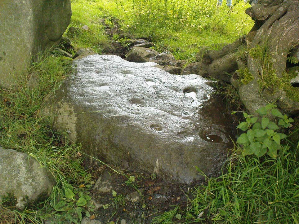
This fine-looking cup-marked stone was uncovered during a botanical outing in the last decade of the 19th century.  Described as being around the township of Rhiwderin, the exact whereabouts of the carving is unknown and it’s not been seen since the first description of it in an early edition of Archaeologia Cambrensis by Mr T.H. Thomas. (1895)  John Sharkey (2004) mentioned the site in his recent survey of Welsh rock art, saying simply “location unknown.”

The missing Rhiwderin stone

Although we know there are no hard and fast rules for working out the location of cup-and-ring markings, one may be fortuitous in exploring any nearby Bronze Age or neolithic tombs (cairns, tumuli, etc) in the Rhiwderin district, as they do tend to enjoy the company of such sites — but I must stress, this is by no means a dead cert!

Mr Thomas’s description of the carving was as follows:

“I enclose a sketch of what seems to be a cup-marked stone which I observed yesterday near Rhiwderin, Monmouth.  Unless there be some operation which simulates such markings with which I am unacquainted, I take the specimen to add an instance of these mysterious prehistoric remains to the very short list given for Wales by Mr. Romilly Allen, and to be the first reported for South Wales.

“The stone displaying the cup-markings is a mass of millstone grit, earth-fast, the slanting surface appearing above the turf being about a yard wide, and 4 feet long.  Upon the upper half of the surface is a group of twelve cups from 1½ to 2in diameter, and about 1in deep. On first noticing the cups they were taken for holes out of which quartz pebbles, abundant in the local millstone grit, had been weathered, but examination of the block showed that no pebbles of large size exist, or had existed in it, and the conclusion was arrived at that the cups are artificial.

“On turning back some of the turf covering the base of the slope of the stone, no other cups were discovered.

“The stone lies within an old enclosure, as shown by wild apple-trees and an abundance of daffodils, and still more clearly by ruins, which seem those of a cottage or small farm near by. This contiguity to a habitation which does not seem to have been abandoned more than a century, made me suspect some medieval or more recent origin for the markings. I cannot, however, account for them otherwise than by supposing them to be cup-markings in the technical archaeological sense.

“The stone was observed while in the company of Dr C.T. Vachell of Cardiff, searching for varieties of narcissus which occur at several points in the neighbourhood…”

If anyone comes across this lost carving, please let us know!

References:

  1. Sharkey, John, The Meeting of the Tracks: Rock Art in Ancient Wales, Gwasg Carreg Gwalch: Llanrwst 2004.
  2. Thomas, T.H., ‘Archaeological Notes and Queries,’ in Archaeologia Cambrensis, volume 12 (5th series), 1895.

© Paul Bennett, The Northern Antiquarian 

The map could not be loaded. Please contact the site owner.


Slade Cairnfield, Blubberhouses Moor, North Yorkshire

Cairnfield:  OS Grid Reference – SE 141 543

Getting Here

One of several recently discovered small cairns

Follow the same directions to reach the recently discovered Slade-02 carving; and simply walk 30 yards southwest.  The scattered ruins of numerous small stone piles, visible only when the heather’s been burnt back, is what you need to be looking for.

Archaeology & History

First discovered on a Northern Antiquarian outing in July 2011, it’s difficult to give an accurate appraisal of this site as much of the landscape all round here is very overgrown in deep heather.   Added to this, there is evidence of more recent medieval and post-medieval industrial activity that’s intruded and/or affected the earlier prehistoric remains that are evident here.  But these factors aside, we can say with certainty that here is a previously unrecognized prehistoric cairnfield — and it may be of some considerable size.

Ruined hut or cairn circle

We have so far located at least seven individual cairns and a cairn circle in relative proximity to each other, thanks to local rangers burning back the heather.  It was the discovery of the cairns which then led to the discovery of the nearby cup-and-ring stones.  Amidst the cairn-spoils there are also distinctive lines of stone, indicative of either walling or embankments of some form or another.  Some of the stone making up this cairnfield appears to have been robbed. We also found that in walking through the deeper heather surrounding this ‘opening’ (where it had been burned away a few months previously), a number of other man-made piles of stone were evident that seemed to indicate more cairns.  There is also evidence of further lines of prehistoric walling, whose precise nature is as yet unknown. But we do know that people have been on this moorland since Mesolithic times (structural and other remains of which are still evident less than a half-mile away).

The site requires greater attention the next time the heather’s been burnt back.

References:

  1. Davies, J., “A Mesolithic Site on Blubberhouses Moor, Wharfedale,” in Yorkshire Archaeological Journal, part 161 (volume 41), 1963.

© Paul Bennett, The Northern Antiquarian

The map could not be loaded. Please contact the site owner.


Badbury Barrow Carving, Shapwick, Dorset

Cup-Marked Stone:  OS Grid Reference – ST 9583 0294

Also Known as

  1. Badbury Rings Carving
  2. Shapwick 6a carving

Archaeology & History

Badbury Barrow carving (after J.F.S. Stone 1958)

Amidst what was once a veritable gathering of prehistoric tombs on the ground immediately west of the Badbury Rings hillfort — a small necropolis no less! — one particular tumulus which Leslie Grinsell named as ‘Shapwick 6a‘ was in the process of being destroyed at the end of October, 1845, but was fortunate in receiving the quick attention of a local historian called John Austen, who gave us the first known account of the place. (a fuller profile of the Badbury Barrow can be found here)  Inside the churned-up remains of Badbury Barrow, which measured 62 feet across and 9 feet high, Mr Austin found a fascinating number of urns and other remains and, shortly after, this rare example of a petroglyph was identified.  The stone now lives in the British Museum where, the last I knew, you could certainly check it out.  But it’s not its original size, as sections of the stone were broken off.  As Aubrey Burl (1987) told us, the stone was originally about half-a-ton in weight, on which,

“were carvings of five cupmarks, two bronze daggers and two flat, triangular axes of early Breton type.”

Grinsell’s more detailed description of the carving from his work on Dorset Barrows (1959) tells a little more of the design found on this seeming ‘tomb-stone’:

“Sandstone slab, probably from stone cist, decorated with pecked carvings of two daggers with hilts, resembling those on stone 53 at Stonehenge; two triangular objects probably intended to be flat bronze axe-heads expanding at their cutting-edge; and five cup-shaped hollows.  The existing decorated fragment (in British Museum) is 1ft 10in long, and was detached from the original slab which weighed probably more than half a ton.  The size suggests, perhaps, a cover-slab.”

It may well have been.  Certainly it had some relationship to death!  The design was suggested in the 19th century to perhaps have been influenced by Greek imagery, when such notions were in vogue.  As Grinsell tells,

“In the centre according to Durden…was the well-known large slab of sandstone which was decorated with carvings of daggers and axes, the former of type similar to those from Stonehenge, conjectured to be of Mycenean type.”

But the Mycenean nature of the carvings is highly unlikely.  What is intriguing with this carving is the appearance of cup-markings (commonly associated in or adjacent to prehistoric tombs) alongside defined symbols of daggers.  We could infer a magickal relationship between the two symbols here: one of which, the cups, comes from a much earlier period than the dagger-design.  A more in-depth analysis of the human remains within the tumulus and a plan of the site would perhaps be more revealing…

…to be continued…

References:

  1. Austen, John H., “Archaeological Intelligence,” in Archaeological Journal, volume 3, 1846.
  2. Burl, Aubrey, The Stonehenge People, Guild: London 1987.
  3. Grinsell, Leslie V., Dorset Barrows, Dorset Natural History & Archaeological Society 1959.
  4. Knight, Peter, Ancient Stones of Dorset, Power: Ferndown 1996.
  5. Royal Commission on Historical Monuments, England, An Inventory of the Historical Monuments in the County of Dorset – Volume 5: East Dorset, HMSO: London 1975.
  6. Stone, J.F.S., Wessex Before the Celts, Thames & Hudson: London 1958.
  7. Warne, Charles, The Celtic Tumuli of Dorset, John Russell Smith: London 1866.

© Paul Bennett, The Northern Antiquarian

The map could not be loaded. Please contact the site owner.


Panorama Stone (226), Ilkley Moor, West Yorkshire

Cup-and-Ring Stone (lost):  OS Grid Reference – SE 1015 4702

Also Known as:

  1. Panorama Rock 226

Archaeology & History

J.R. Allen’s 1879 drawing

It would seem that this excellent looking cup-and-ring stone may have been destroyed sometime around 1890 during the construction of the Panorama Reservoir and the building of the houses on the southwestern edge of Ilkley, right by the moorside.  But this isn’t known for certain; and the carving could still exist beneath vegetation in the trees just north of the reservoir.  In requesting to explore some National Archives data in which there may be information relating to this carving (and others nearby), I was directed to Bradford Council’s community archaeologist, Gavin Edwards (to whom requests should be made), but he denied access to look at the files, then completely ignored subsequent queries that might enable us to locate this and other important prehistoric carvings.  So we did our best and this is what we’ve found so far (forgive any errors).

As there’s a slight ambiguity in the precise location of this lost carving, we cannot say for certain whether or not this site was included in the sale of Property Lots, numbers 7-34, “surrounding the far-famed Panorama Rocks,” which may have led to the site’s destruction and subsequent removal of the protected Panorama Stones to Saint Margaret’s Park on the other side of the road from the church, closer to Ilkley centre.  The sale of this “building land” as it was called was advertised in the Leeds Mercury, Saturday September 4, 1880, with a brief description of the respective “lots” near this and the adjacent carvings.  But this Panorama Stone 226 may have been left alone and be buried under the surface…

J.T. Dale’s 1880 sketch

Historical notes on this particular stone are scattered and sparse, but digging through old journals and texts has given us a reasonably good vision of the place.  It was first described, albeit in passing, in A.W. Morant’s edited third edition of Whitaker’s History of Craven (1878: 289), where it was described in context with the other cup-and-ring east of here on the same ridge.  All of them were described as being located within a now-destroyed prehistoric enclosure (precise nature unknown), with carving 226 at the westernmost end.  However, the following year J. Romilly Allen (1879) gave more details of this, “the third stone” as he called it and furnished us with a damn good drawing to boot!

As we can see, there are four double-ringed cups and eight or nine archetypal cup-and-rings, with the usual scatter of cups falling across the design.  The curious ‘ladder’ markings found on one of the other Panorama Stones, the Barmishaw Stone, Willy Hall’s Wood carving and at least one of the Baildon Moor carvings, were also quite prominent.  Although when J. Thornton Dale visited here around the same time and did his own drawings, the ladders weren’t quite as pronounced.  This would have been due to the simple factors of cloud cover, poorer sunlight and the time of day the drawings were done (the pseudoscientific proclamation of local archaeologist Gavin Edwards that such artistic difference is due to some Victorian chap adding, or removing sections of the carvings for his own pleasure, negates common sense and is strongly lacking in evidence).  Romilly Allen’s own description of the site was as follows:

“The Panorama Rock lies one mile south-west of Ilkley, and from a height of 800 feet… About 100 yards to the west of this spot appears to be some kind of rough inclosure, formed of low walls of loose stones, and within it are the three finest sculptured stones near Ilkley. They lie almost in a straight line East to West… The third and most westerly stone of the group measures 10ft. by 9ft. and lies almost horizontally, having its face slightly inclined. On it are carved twenty-seven cups, fourteen of which have concentric rings round them. Some of the cups have connecting grooves, and three have the ladder-shaped pattern before referred to.”

Notes from a few years later told that this carving was still in situ when the companion carvings were moved and imprisoned behind railings across from St. Margaret’s Church in Ilkley.   The carving was shown at the grid reference given above on the 1895 Ordnance Survey map of the region before the reservoir was built, correcting the coordinates given in Boughey & Vickerman’s (2003) otherwise fine survey.  They described this very ornate carving thus:

“According to Thornton Dale (1880), this was a large rock with 27 cup, eighteen of which had single rings.  Some of the cups had connecting grooves and three had the same ladder motif as the Panorama Stone.”

…to be continued…

References:

  1. Allen, J. Romilly, “The Prehistoric Rock Sculptures of Ilkley,” in Journal of the British Archaeological Association, volume 35, 1879.
  2. Allen, J. Romilly, “Notice of Sculptured Rocks near Ilkley,” in Journal of the British Archaeological Association, volume 38, 1882.
  3. Allen, J. Romilly, “Cup and Ring Sculptures on Ilkley Moor,” in The Reliquary, volume 2, 1896.
  4. Bennett, Paul, The Panorama Stones, Ilkley, TNA: Yorkshire 2012.
  5. Boughey, Keith, “The Panorama Stones,” in Prehistory Research Section Bulletin, no.40, Yorkshire Archaeological Society: Leeds 2003.
  6. Boughey, K.J.S. & Vickerman, E.A., Prehistoric Rock Art of the West Riding, WYAS: Leeds 2003.
  7. Collyer, Robert & Turner, J.H., Ilkley: Ancient and Modern, William Walker: Otley 1885.
  8. Jennings, Hargrove, Archaic Rock Inscriptions, A.Reader: London 1891.
  9. Turner, J. Horsfall, “British or Prehistoric Remains,” in Collyer & Turner, Otley 1885.
  10. Whitaker, Thomas Dunham, The History and Antiquities of the Deanery of Craven in the County of York, (3rd edition) Joseph Dodgson: Leeds 1878.

© Paul Bennett, The Northern Antiquarian

The map could not be loaded. Please contact the site owner.


Eller Edge (429), Pock Stones Moor, Thruscross, North Yorkshire

Cup-Marked Stone:  OS Grid Reference – SE 0902 6150

Also Known as:

  1. Carving no.429 (Boughey & Vickerman)
Eller Edge stone 429

Getting Here

A slight walk to get here.  Follow the same directions as if you’re going to the Eller Edge 431 carving.  Once here, walk west as if you’re going into the middle of the field, keeping your eyes peeled about 20 yards along for a small-ish rounded stone with nice colours of lichen amidst the grasses.  If you’re patient, you’ll find it soon enough!

Archaeology & History

This is another simple cup-marked stone on the grassland ridge overlooking higher Wharfedale.  The carving here is a little clearer and more well-defined than that of its close neighbours, with a number of simple cups visible on its rounded surface.  We counted seven such cups on our cloudy-day visit, but Boughey & Vickerman (2003) thought there might be a little more, describing the stone simply:

from another angle
B & V’s drawing

“Small lichen-covered rough grit rock.  About eight cups and two depressions.”

A rubbing of this small stone (as practiced by English Heritage and rock art students alike) would prove useful in bringing out any other ingredients in the ancient design.  And whilst you’re in this field, have a look at the curious Spiral Stone and some of the other cup-markings close by.

References:

  1. Boughey, Keith & Vickerman, E.A., Prehistoric Rock Art of the West Riding, WYAS: Wakefield 2003.

Links:

  1. Eller Edge Rock Art – more notes & images

© Paul Bennett, The Northern Antiquarian

The map could not be loaded. Please contact the site owner.


Eller Edge (424), Pock Stones Moor, Thruscross, North Yorkshire

Cup-Marked Stone:  OS Grid Reference – SE 08973 61487

Also Known as:

  1. Carving no.424 (Boughey & Vickerman)
Eller Edge carving 424

Archaeology & History

A slight walk to get here, but well worth it once you arrive!  Follow the same directions as if you’re going to the Eller Edge 426 carving.  Once you reach this stone, notice the larger rounded rock about 20 yards to your west, a bit further down the field.  You can’t really miss it!

Archaeology & History

A large rounded stone just on the meadows before it begins to slope more steeply downhill, there are several of those large natural ‘bowls’ that we see on a lot of cup-marked and not-so-cup-marked stones in our northern hills.  These basins or bowls may, at times, may have had significance for our ancestors, but it’s the cluster of cup-markings on this stone which are of importance to us here.  There are perhaps as many as a dozen cup-marks here, all very well worn, and mostly to be seen on the eastern sides of the rock.  When I came here with Paul Hornby and QDanT a few months back, the cloud cover stayed with us all day, so I didn’t get any decent images of the carving.  Ne’er mind…

Close-up of faint cups

The stone was described by Boughey & Vickerman (2003) simply as:

“Very large, uneven, rough grit rock with face with scooped-out areas sloping down to grass.  Eleven possible cups and six basins.”

A plain carving, perhaps only of interest to the fanatics amongst you.  But if you do visit here, check out carving 432, 431, and others in the same field.

References:

  1. Boughey, Keith & Vickerman, E.A., Prehistoric Rock Art of the West Riding, WYAS: Wakefield 2003.

Links:

  1. Eller Edge Rock Art – more notes & images

© Paul Bennett, The Northern Antiquarian

The map could not be loaded. Please contact the site owner.


Eller Edge (432), Pock Stones Moor, Thruscross, North Yorkshire

Cup-and-Ring Stone:  OS Grid Reference – SE 09078 61479

Also Known as:

  1. Carving no.432 (Boughey & Vickerman)
Carving 432, close to the wall

Getting Here

A slight walk to get here.  Follow the same directions as if you’re going to the Eller Edge 426 carving, but as you reach the field edge, walk up the slope (in the field itself) along the side of the wall.  You’ll pass rudimentary Carving 431 and about 30 yards further uphill this little fella will catch your eye!  You can’t really miss it.

Archaeology & History

Another basic cup-marked stone that’s probably only gonna be of interest to the purists amongst you.  A single cup-marking sits on the edge of a small patch of old dark lichen, although the rock art students Boughey & Vickerman (2003) reckon there could be another two on here—but I aint so sure misself.  The stone was described by them simply as:

“Medium-sized rectanguar rock of medium gritstone, with vertical edges except for finely striated sloping W side.  One cup near possibly quarried edge and perhaps two more.”

Single faint cup-mark

Another single cup-marked stone of the same size, type and quality as this one can be found on another stone not far from this stone, which aint in the Boughey & Vickerman survey.  There’s also evidence of ancient lines of walling close by, but with little surface clues as to its age.

References:

  1. Boughey, Keith & Vickerman, E.A., Prehistoric Rock Art of the West Riding, WYAS: Wakefield 2003.

Links:

  1. Eller Edge Rock Art – more notes & images

© Paul Bennett, The Northern Antiquarian

The map could not be loaded. Please contact the site owner.


Guisecliff Wood (629), Bewerley, North Yorkshire

Cup-and-Ring Stone:  OS Grid Reference – SE 16415 63565

Also Known as:

  1. Carving no.629 (Boughey & Vickerman)

Getting Here

A box of cup-and-rings!

Takes a bitta finding this one – especially a this time of year when the bracken’s high – but it’s worth the walk.  You’re probably best finding your way to the open-air carving on the slopes above Westcliff Farm, the Guisecliff Wood 626 carving (it’s pretty easy to find).  From here, walk eastwards across the top of the two fields until you hit the old gate that take you back into the woods.  Now it gets difficult!  Walk less than 100 yards in the same direction, if you’re lucky, along the small footpath that runs pretty level through the trees, keeping your eyes peeled for a large sloping rock above you.  I’d say that it’s probably best to start checking the relevant rocks (large ones) after 50 yards in the trees, just to be on the safe side.  If you aint been here before it’s probably best to check it out at the end of Winter or during Spring time.  Good luck!

Archaeology & History

As noted by several people in our visit here the other day, some aspects of this carving are similar in design to the Tree of Life Stone on the eastern edge of Askwith Moor, 10 miles south of here.  But the features on this large carved rock have intriguing elements of their own here: not least of which is the large square ‘box’ into which a cluster of otherwise normal cup-and-rings are enclosed.  It’s a unique feature in prehistoric carvings in this part of the world — although such ‘box’ motifs can be seen further north at Dod Law in Northumberland.

The fainter cup-and-rings
Boughey & Vickerman’s 2003 drawing

There are two distinct sections of carvings on the stone, both of which have a similar tree-motif patterns, but the boxed one grabs your attention more once you’ve sat with the stone for a while. The other small cluster of cups are a little more difficult to notice, but once you see them they almost grow into life!  You can just make out the surrounding rings and lines around some of these fainter cups, which I tried to capture in the photos (but without much success).

Our visit here didn’t pass without some voicing the thought that ‘box’ section could have been added at a much later date — perhaps a Victorian addition?  But we could be way off the mark with that one!

There’s every likelihood of other carvings being found in and above the woodlands here, though any further exploratory excursions here can wait till winter time, as the Nature’s summer growth here is considerable and covers most of the rocks in green.  The carving was first described in Boughey & Vickerman’s (2003) text as a

“Very large rock with extensive flat surface on which there seems to be two separate designs.  Seven cups are joined in a branch-like pattern, the whole within a square groove from which the ‘stem’ of the branch just protrudes; away from this is an approximately linear feature with three cups enclosed by linked rings at one end and then six more cups with a partial ring.”

If you’re a rock art enthusiast, or a real healthy heathen, this site is well worth checking out!

References:

  1. Boughey, Keith & Vickerman, E.A., Prehistoric Rock Art of the West Riding, WYAS 2003.

Links:

  1. More images of Guisecliff Wood carvings

© Paul Bennett, The Northern Antiquarian

The map could not be loaded. Please contact the site owner.


Fertility Stone, Dacre, North Yorkshire

Cup-and-Ring Stone:  OS Grid Reference – SE 18552 62228

Also Known as:

  1. Carving no.638 (Boughey & Vickerman)

Getting Here

Fertility Stone carving

Take the same directions as if you’re visiting the Eastwoods Cross base and cup-marked stone, but at Eastwoods Farm itself, walk downhill following the field-wall, past the large house, then through the first gate you come to. (it’s got a ‘private’ sign on it and has some handy bulls in the field – but ask at the house and the folks there are friendly)  Following the footpath along the top of the field, cross the small stream, then head across the next field to the gap in the wall.  You’re here!

Archaeology & History

Boughey & Vickerman’s 2003 sketch

One of a cluster of cup-and-ring stones around the Bryan’s Wood and Eastwoods area, this carving is well worth a visit, but can be covered in shit and muck as the bulls pass through the gap here on their daily amble.  If the daylight isn’t good here, it can be difficult to see the carving – and when we visited the place the other day, the cloud was low and the heavens were ready to open, so our luck was out for a change!  There are a number of cup-and-rings plus a double-ring, fading their ways around the more defined cup-markings.  The stone appears to have been found in the 1990s, but records of it are scant.  Boughey & Vickerman (2003) fail to tell the origin of the name, nor when or who rediscovered the site.  Their description of the carving tells simply:

“Large flat smooth rock sloping slightly to E.  Thirteen possible cups, one with partial double ring and four with partial single-rings; three ringed cups have grooves leading from them.”

Several other excellent cup-and-ring carvings can be found around here.  The hugely impressive Morphing Stone and a prehistoric lightning-carving can be found three fields away to the south, past the trees on the other side of the stream.

Folklore

Close-up of the stone

The title of ‘fertility stone’ seems a modern one, although word has it that it relates to Beltane fertility rites.  However, I can find no documentary information relating to this, and the people at Eastwoods Farm and adjacent house know nothing to account for it.

References:

  1. Boughey, Keith & Vickerman, E.A., Prehistoric Rock Art of the West Riding, WYAS 2003.

Links:

  1. Graeme Chappell on the Fertility Stone
  2. Guidecliff Woods & Fertility Stone images

© Paul Bennett, The Northern Antiquarian

The map could not be loaded. Please contact the site owner.


Guisecliff Wood (626), Bewerley, North Yorkshire

Cup-and-Ring Stone:  OS Grid Reference – SE 16078 63641

Also Known as:

  1. Carving no.626
  2. Hogback Stone
  3. Lower Intake carving
Carving 626, looking NNW

Getting Here

From Pateley Bridge take the B6265 road towards Grassington, turning left just a coupla hundred yards over the river bridge, towards Bewerley.  Go through the hamlet and take the second on the right, up the steep zigzagging lane.  A half-mile up the hill, watch out for the track onto Westcliff Farm.  Go along here and onto the footpath, then as you walk through the field, look uphill where the long wall runs into the trees, and you’ll see a rock in the walling near the top.  That’s it!

Archaeology & History

Just over the edge of the northern section of The Intakes at the western end of Guisecliff Wood, on a large rock in the walling near the very top of the field above Westcliff Farm, we find this little-known but very impressive cup-and-ring stone.

Close-up of some cups
Boughey & Vickerman’s drawing

Upon first sight the rock was aptly described by Danny Tierney as being like a Viking Hogback Stone with cup-markings along the sloping side of the long rock as it grew into the drystone walling.  He had a point!  It’s a curious carving (how many times do I say that!?), with the majority of the cup-marks and lines etched into the south-sloping face of the rock.  Other cups found further down the stone stretch along the eastern side towards ground level; and we have a small line of cups etched onto the normal horizontal face halfway along the stone.

The carving was rediscovered by Stuart Feather in the ‘Sixties and was all-but-forgotten until Boughey & Vickerman (2003) rejuvenated it in their catalogue.  They told it to be:

“Large rock of coarse grit lying with long uneven surface E to W, at ground level to S and E, but with high N and W faces.  Up to eighty cups but some may be due to pebbles or other natural causes; one cup has two half-rings which, like some grooves visible, suggest a now incomplete design.”

The fascinating ‘boxed’ cup-and-ring stone of Guisecliff Woods 629 can be found less than 200 yards east of here, in the trees, and is certainly worth seeking out!

References:

  1. Boughey, Keith & Vickerman, E.A., Prehistoric Rock Art of the West Riding, WYAS 2003.
  2. Feather, Stuart & Hartley, C.E., “The Yorkshire Archaeological Register, 1964: Bewerley. W.R.”, in Yorkshire Archaeological Journal,  volume 41, 1965.

Links:

  1. More images of Guisecliff Wood carvings

© Paul Bennett, The Northern Antiquarian

The map could not be loaded. Please contact the site owner.