Devil’s Dyke, Poynings, Sussex

Hillfort:  OS Grid Reference – TQ 260 111

Also Known as:

  1. Brighton Dyke
  2. Poor Man’s Wall 

Getting Here

Map of Devil's Dyke
Map of Devil’s Dyke

Plenty of ways of approaching this huge fella!  Personally, I’d take it from the steep valley immediately east and north where the ramparts drop you down the hill, if only to get a decent idea of the scale of the thing!  But those of you into taking it easy can do no better than take the country road south out of Poynings village (towards Brighton), down Saddlescombe Road, for just under a mile, where you should take a right-hand turn along the Summer Down lane for a mile. You’ll then hit the Devil’s Dyke Road. Turn right here and go to the end.  You’re right in the middle of it!

Archaeology & History
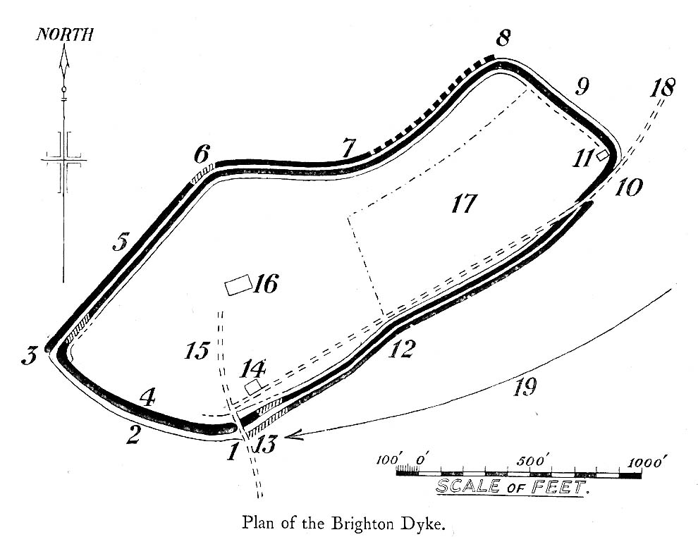
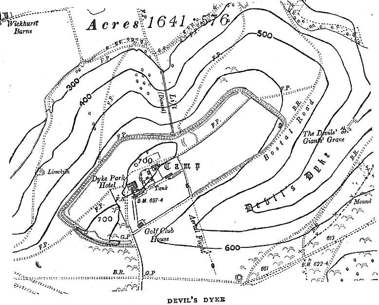
Early plan of Devil’s Dyke ‘camp’

Although most of this huge monument hasn’t been given the investigation it deserves — hence making knowledge of its origins more speculative than factual — as Jacquetta Hawkes (1973) wrote, seemingly all those years ago now, “it is known that a village lying half in and round them was occupied in the Belgic period at the end of the Iron Age.”  And it’s certainly big enough!  The encircling circuit of dykes themselves stretch all the way round a distance of more than 2150 yards long (that’s 1.22 miles, or 1.97km!), with the longest east-west axis being more than half-a-mile across.

Nowadays it seems, the Devil’s Dyke is the name given to the steep valley below the encampment, but a hundred years back it was the camp itself that was known by this name.  Described by the wandering antiquarian R. Hippisley Cox (1927) as “a camp containing forty acres (with) very steep and difficult approaches,” another early account in The Antiquaries Journal — commenting on a ground-plan of the site from the Brighton and Hove Herald of 1925 — told:

“The heavy encircling lines represent ramparts, and the thin line marks the outer margin of the accompanying ditch.  A spur renders the earthwork weakest on the south-west, and the rampart is therefore highest between the points 1 and 3, rising 21ft vertically above the ditch, which is nearly filled up at the present time.  On the north-west there is steep slope outside the camp, and the ramparts are considerably lower, the iner ditch being nearly obliterated.  The outer rampart is now wanting betwen 7 and 8, but this inner one becomes stronger as the outer slope of the ground decreases, only to die away again on the south-east where the camp overlooks the steep Dyke Valley.  A double-bank and inner ditch can still be traced from the north-east angle to a point near the old golf-club house.”

I first came here as a young lad and the site was lost on me (in them days, if monuments weren’t stiff and upright, I really didn’t see the point!).  These days however, the size of it alone blows you away somewhat.

Folklore

As you’d expect the creation myths of this site and its edges relate to our old heathen friend, the devil!  The landscape itself was, in old lore, the work of the devil (though prior to this, the devil was known in peasant-lore to be a legendary giant, though I am unaware of the name/s of the giant in question); and the great valley below the Devil’s Dyke encampment was actually dug out by Old Nick in the old tales.  That old folklorist Jacqueline Simpson (1973) takes up the story:

“The Devil…had been infuriated by the conversion of Sussex, one of the last strongholds of paganism in England, and more particularly by the way the men of the Weald were building churches in all their villages.  So he swore that he would dig right through the Downs in a single night, to let in the sea and drown them all.  He started just near Poynings and dug and dug most furiously, sending great clods of earth flying left and right — one became Chanctonbury, another Cissbury,  another Rackham Hill, and yet another Mount Caburn.  Towards midnight, the noise he was making disturbed an old woman, who looked out to see what was going on.  As soon as she understood what he was up to, she lit a candle and set it on her window-sill, holding up a sieve in front of it to make a dimly glowing globe.  The Devil looked round, and thought this was the rising sun.  At first he could hardly believe his eyes, but then he heard a cock crowing — for the old woman, just to make quite sure, had knocked her cockerel off his perch.  So Satan flew away, leaving his work half done.  Some say that as he went out over the Channel, a great dollop of earth fell from his cloven hoof, and that’s how the Isle of Wight was made; others, that he bounded straight over into Surry, where the impact of his landing formed the hollow known as his Punch Bowl.”

That’s the story anyway — take it or leave it!  Of importance in this fable is the figure of the “old woman”: a much watered-down version of the cailleach figure of more ancient northern and Irish climes, where tales of her doings are still very much alive.  And many are the tales of her battles with other giant figures, just as we evidently once had here.

Ghosts have been reported by local people upon this hill-top site; and there are a number of other folktales to be found here…which I’ll unfold over time as the months pass by…

References:

  1. Anon., “Notes: The Brighton Dyke,” in The Antiquaries Journal, 5:4, October 1925.
  2. Clinch, G., “Ancient Earthworks,” in Victoria County History of Sussex – volume 2 (edited by W. Page), St. Catherine’s Press: London 1905.
  3. Cox, R. Hippisley, The Green Roads of England, Methuen: London 1927.
  4. Hawkes, Jacquetta, A Guide to the Prehistoric and Roman Monuments in England and Wales, Chatto & Windus: London 1973.
  5. Hogg, A.H.A., “Some Aspects of Surface Fieldwork,” in The Iron Age and its Hillforts (edited by M. Jesson & David Hill), Southampton University Archaeology Society 1971.
  6. Simpson, Jacqueline, The Folklore of Sussex, Batsford: London 1973.
  7. Simpson, Jacqueline, “Sussex Local Legends,” in Folklore Journal, volume 84, 1973.

© Paul Bennett, The Northern Antiquarian


Adam’s Oak, Brierley, South Yorkshire

Legendary Tree:  OS Grid Reference – SE 4280 1015

Also Known as:

  1. Adam & Eve’s Oak
  2. Wind-gap Oak

Archaeology & History

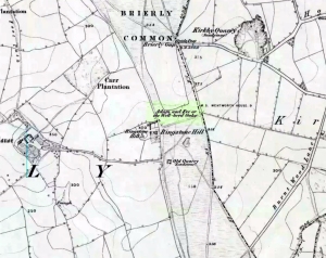
Highlighted on the 1854 Ordnance Survey map close to the township boundary line as Adam & Eve’s Oak, between Brierley and South Kirkby, I can’t find too much about this once great tree.  However the Wakefield historian W.S. Banks (1871) told us the following:

“Upon the common at Ringston Hill grows the remarkable ‘old Adam’ oak, much decreased in size in late years.  It is an ancient and large tree measuring twenty-seven feet in girth at a yard above the ground.  The trunk is hollow and the north side is broken away.  Most of the branches are also gone.  In 1868 a very large branch was blown off by the wind; but on the southerly side are still some very vigorous limbs.”

The old oak on the 1854 map

Even when Banks wrote this he said how the tree “must be many centuries old.”  In the time of King Charles II there used to be an old inn by Adam’s Oak at the foot of Ringston Hill, where the famous highwayman, Nevison (much-loved by many Yorkshire-folk because of his Robin-Hood-like character), used to stay.  The inn was owned by one Adam Hawksworth, but was ordered “to have his sign taken down for harbouring Nevison.”

Folklore

W.S. Banks also wrote of this once great tree:

“The people at Brierley tell of Nevison the highwayman lodging in it and hiding stolen treasures in it, things which probably did not happen, though Nevison’s name is connected with Ringston Hill.”

The treasure legend may have more to do with the adjacent stone circle, as we find ‘treasure’ a common motif at such places.

References:

  1. Banks, W.S., Walks in Yorkshire: Wakefield and its Neighbourhood, Longmans, Green  Co.: London 1871.

© Paul Bennett, The Northern Antiquarian 


Nine Stones Close, Harthill, Derbyshire

Stone Circle:  OS Grid Reference – SK 2254 6264

Also Known as:

  1. Grey Ladies
  2. Hartle Moor Stone Circle

Getting Here

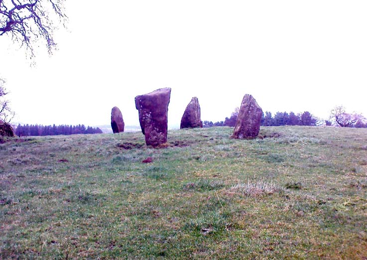
Nine Stones Close circle

From Bakewell take the A6 Matlock road, follow this till just past the signs for Haddon Hall where you take a right (the first major junction) for Youlgreave the B5056.  After about 1km take the first left over the bridge.  You then take the first right turn: a steep lane with restriction signs (don’t worry there’s access for cars but no wide vehicles). Take the first left you come to by the barn and then just follow the road, up through the woodland where the lane narrows then shortly after you’ll see Robin Hood’s Stride to your left.  Park a little way after the field gateway and look across the field to your left.  The stones are visible from the road.

Archaeology & History

This is a fine-looking ring of stones — though perhaps the word ‘ring’ is slightly misleading here, as only four of (apparently) nine originals still remain and they are, by definition, more in a square-shape than a circle!  But it’s a lovely site.  When Geoff brought us here for the first time only last weekend, despite the dark clouds and cold grey day, along with the fact that we’d been sleeping rough the night before and got soaking wet through, there was a subtle feel to this place which my shivering senses still touched.  Only just though…!

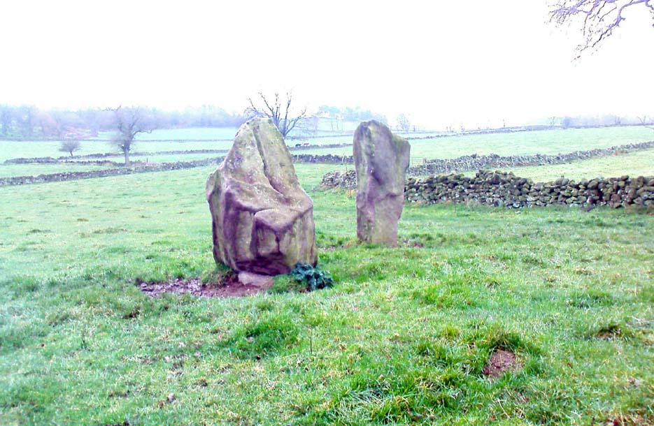
Two southernmost stones

Mebbe it was the rising crags of Robin Hood’s Stride to its immediate south?  Or the quietly hidden companionship with other stones and sites in the locale?  I don’t really think so.  There was something a little more about its own genius loci that tingled very slightly on the rise in the field upon which the circle sits.  Some people would, perhaps, acquaint my sense of a subtle genius loci here to the various leys or ley-lines that have been drawn through here by other writers— but it wasn’t that.

When earlier writers came here, they too had various inspirations of differing forms.  John Barnatt’s (1978) early impressions of the place had him signing astronomical events in and around the remaining stones here, despite knowing that the site had been damaged.  In later years he revised his early notions — as most of us do as our perspectives are enriched — but the astronomy is still assumed here.  As Clive Ruggles (1999) told:

“Other rings are located where natural features coincide with astronomical events, such as Nine Stone Close in Derbyshire…from which the Moon at the southern major standstill limit, sets behind the gritstone crag of Robin Hood’s Stride to the SSW, between ‘two stubbly piles of boulders jutting up at either end of its flat top.'”

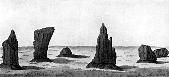
Major Rooke’s drawing of the Nine Stones Circle, c.1780

The stones that remain here are quite tall, between 6½ and 8 feet tall.  One of them seems to have originally been taken from a stream or river-bed.  They stand upon the small rise in the field and has diameters of 40 and 45 feet respectively.  Aubrey Burl described there being seven uprights still here in 1847, and the early drawing of the site near the end of the 18th century by Major Hayman Rooke highlights 6 stones around the spot where the circle now stands.  In J.P. Heathcote’s (1947) summary, he wrote that,

“Bateman, in his Vestiges, says an excavation in 1847 yielded some indications of interments in the form of ‘several fragments of imperfectly-baked pottery, accompanied by flint both in a natural and calcined state.’  In 1877, Llewellyn Jewitt and Canon Greenwell…turned their attention…to the Nine Stones.  They dug at the foot of the second highest stone and the Canon directed a good deal of digging within the circle, but nothing special turned up. The area in the circle is now quite level, but it is probable that there was, as Bateman says, a tumulus in the centre.”

This latter remark is the impression I got of the place.  Tis a really good little site.  All around here are a number of other sites: cup-marked stones, enclosures or settlements, prehistoric trackways, and more.

Folklore

One of the old names of this site was The Grey Ladies.  This came from the well known tale found at other sites across the world, that some ladies were dancing here at some late hour and were turned into stone.  A variation on this theme told how Robin Hood stood on the nearby rock outcrop to the south and pissed over the landscape here, “where seven maidens upon seeing it turned to stone.”  In this case, Robin Hood replaced an older, forgotten account of a giant, who forged the landscape and the sites around Harthill Moor.

Another tale — whose origins and nature are allied to that of the petrification of the Grey Ladies — narrated with considerable sincerity by local people, was that the circle was a place where the little people gathered and where, at certain times of the year, “fairy music and the sight of hundreds of dancing shapes around the stones” would happen.

Said by Rickman and Nown (1977) to be “Derbyshire’s most magical ancient site,” they thought the site was on a ley that linked up with Arbor Lowe, less than 5 miles west, crossing a couple of tumuli on its way.

References:

  1. Barnatt, John, Stone Circles of the Peak, Turnstone: London 1978.
  2. Burl, Aubrey, A Guide to the Stone Circles of Britain, Ireland and Brittany, Yale University Press 1995.
  3. Clarke, David, Ghosts and Legends of the Peak, Jarrold: Norwich 1991.
  4. Heathcote, J. Percy, Birchover – Its Prehistoric and Druidical Remains, Wilfrid Edwards: Chesterfield 1947.
  5. Rickman, Philip & Nown, Graham, Mysterious Derbyshire, Dalesman: Clapham 1977.
  6. Ruggles, Clive, Astronomy in Prehistoric Britain and Ireland, Yale University Press 1999.
  7. Thom, A., Thom, A.S. & Burl, Aubrey, Megalithic Rings, BAR: Oxford 1980.

© Paul Bennett, The Northern Antiquarian


Pots and Pans Stone, Greenfield, Lancashire

Legendary Rocks:  OS Grid Reference – SE 01008 05072

Also Known as:

  1. Druid Stone

Getting Here

Pots & Pans on 1854 OS-map

Dead easy! From the townships of Grasscroft, Uppermill, or Greenfield, take the legendary moorland road up to Saddleworth tops (A635), keeping your eye on the modern obelisk on the hilltop to your left and you’ll see a large rock outcrop almost next to it.  That’s where you’re heading.  Once you reach near the moorland level, walk in whatever way you see fit towards the obelisk and large stones.  Enjoy…!  I s’ppose though, it’d be better for you if you started from the valley bottom at Uppermill and walked up the hill.

Folklore

Seemingly a ritual place of the sun, this fine site was known by the local folk-name of the Druid Stones, according to Jessica Lofthouse. (1976)  But more importantly in legend, this great rocky outcrop was the abode of an old giant called Alphin, who had a rival called Alder who also wandered the moors here.  Both these giants vied for the hand of a lady called Rimmon, who preferred Alphin to Alder. In good old fashioned ways they contested for her hand, throwing giant rocks across the moors at each other, but “Alphin was hit and killed, with Rimmon looking on.”  His grave lies on these moors somewhere, seemingly unfound.   …And intriguingly it seems that we’ve actually located a prehistoric tomb which may account for the legend of Alphin’s death! (Watch this space!)

A slight variation on the tale describes the Lady Rimmon to be of fairy stock, named ‘Raura Peena’ (a phonetic spelling of a local dialect name), who in one account from the Notes & Queries journal, 1850, tried luring a local man into her magickal recess of the Fairy Holes, on the slopes beneath the Pots and Pans Stone.

Local tradition also tells that the naturally-worn ‘bowls’ atop of the rocks held magical properties — water being collected from them was said to be good to cure eye problems.  This is a curative theme we find at some bullauns, cup-marked stones and old cross-bases and would strongly indicates that pre-christian practices did once take place here.

References:

  1. Lofthouse, Jessica, North Country Folklore, Robert Hale: London 1976.

© Paul Bennett, The Northern Antiquarian


Man Stone, Whitworth, Lancashire

Legendary Rock:  OS Grid Reference – SD 893 171

Also Known as:

  1. Monstone

Getting Here

Man Stone on 1851 map

In terms of getting here, follow the directions given by H.C. Collins (1946), who reached here from Healey, north of Rochdale.  “Once past Lousy Hillock the track continues in front of Brown House Reservoir… The track climbs Faffelty Brow under the lea of Man Stone Edge on the left”, above the Rossendale Way footpath. You can of course come straight up from Whitworth, heading up the eastern hill over Lobden golf course.  The site’s to the northeast edge of the course.

Folklore

I first read of this a couple of decades back, in Jessica Lofthouse’s (1976) folklore book, but her pronunciation of the site — which I sought and sought, without success — made finding the place really troublesome.  Thankfully, the local guidebook of Harold Collins (1946) has brought this site into focus once more and, it would seem, the probable site of prehistoric archaeological remains.  But until we get over here and have a good look round, that aspect of the Man Stone will have to await assessment.

Collins (1946) described the “huge stone on the moortop on the left of the track” he’d been walking along, telling how “according to legend it bears the imprint of a human hand and was thrown (here) from Blackstone Edge by Robin Hood.”

Lofthouse (1976) told similarly when she was describing the folklore of Robin Hood’s Bed, about six miles east of here, by the Yorkshire-Lancashire border, saying,

“Robin was a mighty hurler as well as a bowman without peer.  To while away waiting time in the Bed he took a large boulder from the giant’s overspill at hand, threw it and watched its course.  Six miles away on Monstone Edge that boulder dropped, a feat amazing , and has been called Robin Hood’s Quoit ever after!”

But the “quoit”, said Lofthouse, was there centuries before any legendary Robin Hood — as it would have been.  As far as I can find though, no such prehistoric relic ‘officially’ exists upon this hill.  But as those of us who’ve been into seeking these old sites know, that doesn’t necessarily mean a thing.  Henry Fishwick’s (1889) notes about the markings on the rock — “and certain impressions on its surface are said to be the marks of the fingers and thumb of the thrower” —may also prove fruitful.

Adding fuel to an authentic animistic history is the existence, once, of the Old Man’s consort: his Old Woman, or Cailleach, whose well and other landscape features existed to the north.  Much of our peasant history is clearly just beneath the surface in this unexplored archaeomythic region…

References:

  1. Collins, H.C., Rambles round Rochdale, Thomas Yates: Rochdale 1946.
  2. Fishwick, Henry, History of the Parish of Rochdale, James Clegg: London 1889.
  3. Lofthouse, Jessica, North Country Folklore, Robert Hale: London 1976.

© Paul Bennett, The Northern Antiquarian 


Worm Well, Fatfield, Durham

Sacred Well: OS Grid Reference – NZ 3115 5401

Getting Here

This seems a bittova cheat really – and on two counts: i) I aint been here yet; and ii) we’re not sure that there’s any remains left to be seen.  But these notes might produce a result, so direction pointers are worthwhile I reckon!  Various ways to come, but you need to end up on the weird-sounding Bonemill Lane – whether you get there via Worm Hill Terrace or Biddick Lane aint important.  Once on the right road, you wanna stand by the supposedly haunted Biddick Inn, and walk down the road a short distance until you reach a path on your right which heads up towards the ruined Worm Hill.  Halfway along here – or thereaboots – the old Worm Well could once be seen.

Archaeology & History

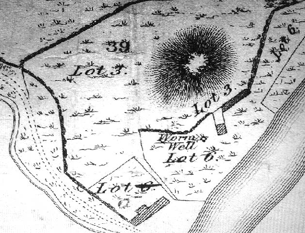
This was initially very difficult to pin down with any certainty, though after a few hours investigation, Keighley archives researcher Michala Potts found it highlighted on a field-map of the region from 1750, as the illustration here clearly shows.

Map highlighting the Worm Well, 1750
Map highlighting Worm Well, 1750

During its “missing years”, several accounts describe the well as being between Worm Hill and the River Wear, which is what’s clearly shown here.  So the possible confusion there may have been (which I initially had aswell) between the riverside spring opposite the pub and the now missing Quarry Well on the far western side of Worm Hill, can at least been dispelled.   The position of the site was described by the holy wells writer, Alan Cleaver [1985], who told that “the well still exists, having been restored in 1974, at the foot of Worm Hill at Penshaw on the north bank of the river.”  Local history records tell that a plaque commemorating the site was put here the same year; and this note is again confirmed in Paul Screeton’s [1978] excellent survey of the dragon legends hereabouts.  Records from the mid-18th century tell that the Worm Well possessed “a cover and an iron dish or ladle” (Binnall & Dodds 1943) to protect the waters.

Folklore

We find from old records that in the middle of the 18th century, “it was a wishing well and a place of festivity on Midsummer Eve.”  The common veneration of crooked pins were offered at this legendary site.

…And then, of course, we have the great Legend of the Lambton Worm, whose spirit form gives this site so much importance.  This well-known folk-tale tells that the great serpent emerged from this very water source.  In this renowned creation myth of the landscape, and the sites upon it, we have the dragon, the cailleach, the waters, and more…

In a recent narrative of the Lambton Worm story, author Karen Liebreich (2012) sent us an excerpt from her new book, UneXplained: Spine-tingling tales from Real Places in Great Britain and Ireland, which outlines more of the tale.  Karen writes:

“Simon, the heir to Lambton Castle, was a wild boy who never paid attention to his lessons or his elders. He liked only to play with the local boys from the village and their games were rough and annoyed other people. They went joy-riding with carts and donkeys, they stole apples from the trees, they frightened younger children. They liked to go hunting for rabbits and fishing for eels in the local river. The lord of the manor, Simon’s father, thought his son should behave better since one day he would be in charge. Simon could not be bothered.

“One Sunday, when he should have been in church, Simon played truant with Stephen, his friend, and two other boys from the village, and went fishing in the river Wear.  After hours of dull waiting, chatting and eating their picnic, Simon caught a strange-looking animal. It did not look like the regular eels and small fish they usually caught. It was no longer than his finger, dark green and with two little fins on its back. Its skin was rough and scaly, and it had four short legs, with sharp clawed feet. Its face was repellent, with a long pointed snout, twelve little teeth sharp as pins, and red glowing eyes.

“Stephen peered over Simon’s shoulder at the animal. “Yuk, throw it back,” headvised. But Simon had caught nothing else, and he was intrigued by the little beast. He put it in his pouch. As the boys walked home, kicking stones and chatting, they noticed a foul smell. It came from Simon’s pouch. They were just passing the well by the castle, so Simon tossed the squirming worm in, and promptly forgot all about it….”

Read the rest of the story in on Kindle at – http://amzn.to/SsjKK6

…to be continued…

References:

  1. UneXplained - LiebreichBinnall, P.B.G. & Dodds, M.H., ‘Holy Wells in Northumberland and Durham,’ in Proc. Soc. Antiq. Newcastle-upon-Tyne, 4th series, volume 10:2, January 1943.
  2. Cleaver, Alan, ‘Holy Wells – Wormholes in Reality,’ in Source magazine, no.3, November 1985.
  3. Liebreich, Karen, UneXplained: Spine-tingling tales from Real Places in Great Britain and Ireland, Kindle 2012.
  4. Screeton, Paul, The Lambton Worm and other Northumbrian Dragon Legends, Zodiac House: London 1978.

© Paul Bennett, The Northern Antiquarian


Cow & Calf (& Bull) Rocks, Ilkley Moor, West Yorkshire

Legendary Rocks:  OS Grid Reference – SE 1306 4679

Getting Here

Dead easy!  Get to Ilkley train station and look across the road to your left, cross it and walk along.  100 yards on is Cowpasture Road.  Walk up it!  You’ll be at the rocks in 10-15 minutes.

Archaeology & History

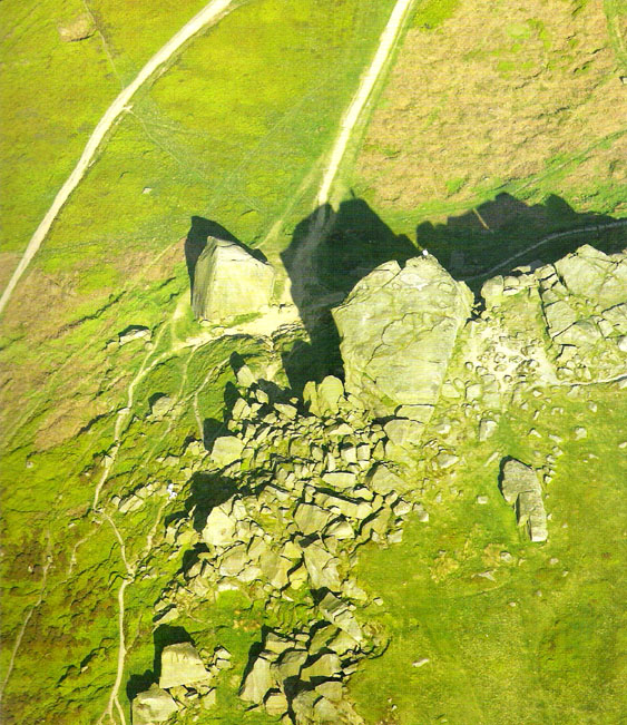
Cow & Calf Rocks from above - thanks to Jason Hawke's superb 'Yorkshire from the Air'
Cow & Calf Rocks from above – thanks to Ian Hay’s superb ‘Yorkshire from the Air’

There’s nowt specifically archaeocentric directly relating to these great rocks — well, nowt that’s been found out about anyway! — though all around here over the last coupla centuries people have found numerous flints, and we have various examples of rock-art (cup-and-rings) carved on rocks close by.  There have been attempts to verify what may be cup-marks on both the Cow and the Calf — with the old master, Harry Speight (1900) telling how there used to be remains of cups and lines on the rocks, but apart from some well-worn ‘cups’ on some of the edges, these seem hard to find.  For worrits worth: if Speight said there were some carvings here, its more than likely true.

I think the main relationship ancient man would have had with this great rock outcrop would have been a ritual one: the rocks themselves had no need of human imprints: their size and nature would deem them of great spirit indeed, to anyone with an ounce of feeling.  Not sure that’s the way most modern folk would see things – but that’s to be expected I s’ppose!

Folklore

These grand rocks once had the even greater Bull Rock as a close companion. It was on top of this, wrote Eric Lodge (1939:40), that,

“the only point in the immediate vicinity of Ilkley from which a view of York Minster was obtainable. ‘Tis some sixty years ago, however, that a local tradesman recognised its value in building stone, and despite strong protests, quarried it for the construction of the Crescent Hotel, situated at the corner of Brook Street and Leeds Road in Ilkley.”

The matter was described in the Leeds Mercury in 1899, thus:

“About the year 1850 an act of vandalism was perpetrated at Ilkley, which would have been impossible in these days, when the Ilkley Local Board watches with such a keen eye anything that may enhance the historical interest of this rapidly increasing watering-place.

“Below the two huge rocks known as ‘The Cow and Calf,’ which have attracted thousands of visitors and invalids on to the breezy heights whereon they stand, stood a rock larger than the Calf, which was known as the ‘Bull.’  It was much nearer the highway than the Calf…

“The ‘Bull’ rock had its name cut in large letters on the side that lay nearest the road, and it is much to be regretted that an unfortunate dispute between the owners of the free-hold and the lord of the manor, in which the former won the day, gave them the right to break up this noble rock and cart it away for building purposes. It is said that the Crescent Hotel was mainly built from this stone, so some idea may be formed of its vast size and proportions.”

Incredible – they’ve turned a gigantic sacred rock into a large hotel! (and I’ve never been in it) Let’s hope it’s haunted to buggery!  Does anyone know any Fortean history about the place?

Another legend tells that one day the local giant, Rombald (who gave his name to these moors and lived up here, somewhere, with his even greater but unnamed wife), decided to meet a friend a few miles away to the east, at Almscliffe Crags.  So in just one step he strode over the Wharfe valley right across to the legendary crags, but he slightly stumbled and in doing so, left he footprint embedded on the face of the Cow Rock, which can still be seen today.

In modern times, the Cow & Calf have been the centre for occasional UFO, or earthlight sightings.  But this appears to go back a bit earlier than when such curious light-forms were thought of as visiting ETs; for good old Nicholas Size (1936) reported seeing burning lights and curious figures up here — but when he saw these lights they took the form of druids and pagan spirits.  One wonders what they’ll morph into next!

References:

  1. Bennett, Paul, The Old Stones of Elmet, Capall Bann: Milverton 2001.
  2. Collyer, Robert & Turner, J. Horsfall, Ilkley Ancient and Modern,William Walker: Otley 1885.
  3. Cowling, E.T., Rombald’s Way, William Walker: Otley 1946.
  4. Hay, Ian & Pritchard, Lisa, Yorkshire from the Air, Myriad: London 2005.
  5. Lodge, Eric, Yorkshire Walks, Arthur Wigley: Leeds 1939.
  6. Size, Nicholas, The Haunted Moor, William Walker: Otley 1936.
  7. Speight, Harry, Upper Wharfedale, Elliott Stock: London 1900.

© Paul Bennett, The Northern Antiquarian


Hitching Stone, Keighley Moor, West Yorkshire

Legendary Rock:  OS Grid Reference – SD 98665 41698

Getting Here

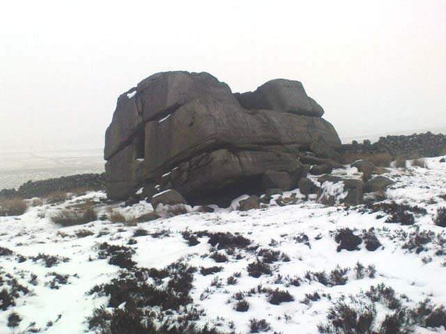
Hitching Stone through fog and snow
Hitching Stone through fog & snow

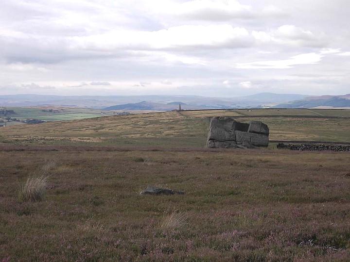
The easiest way to get here is via Cowling – though you can approach the place via moorland roads from Sutton-in-Craven, Oakworth and Keighley, but Cowling’s the closest place (so we’ll take it from there).  Turn east off the A6068 up Old Lane at the Ickornshaw side of town and go up the steep and winding road until you hit the moors.  Just as the road levels out with walling on either side of the road, there’s some rough ground to your left.  You can park here.  You’ll blatantly see our Hitching Stone on the moorland a few hundred yards above you on the other side of the road.  Walk up the usually boggy footpath straight to it!

Archaeology & History

For me, this is a superb place! Each time I come here the place becomes even more and more attractive — it’s like it’s calling me with greater strength with each visit.  But that aside…

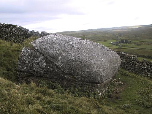
Supposedly the largest single boulder in Yorkshire, it possesses several legends, aligns with the sacred Pendle Hill in Lancashire, is an omphalos (centre of the universe spot) and has other good points too! My first visit here was near the end of the Great Drought of 1995.  All of the streams and springs had dried up on the moors but, on the very top of this huge rock, measuring at least 8 feet by 4 feet across (and 3 feet deep) was a large pool of water, not unlike a bath, in which a couple of you could easily bathe (and do more besides, if the fancy takes you!).  It was surreal!  Water-boatmen and other insects were living in this curious pool on top of the rock.  Yet all other water supplies for miles around had long since dried-up.  It didn’t really seem to make sense.

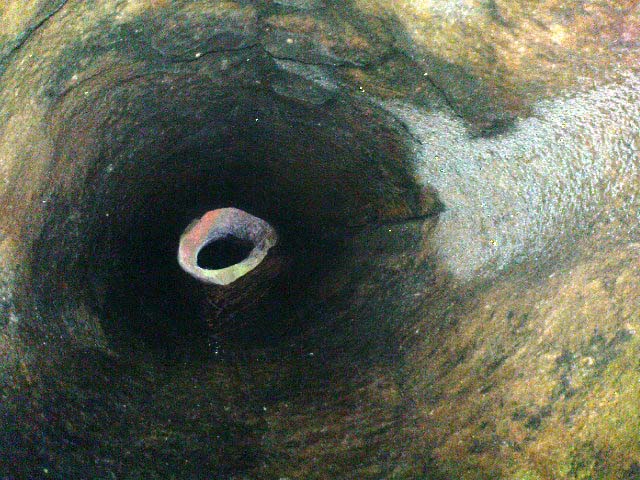
Crystalline tunnel in the Hitching Stone

On the west-facing side of the boulder, about 8 feet up, is a curious deep recess known as the Druid’s or Priest’s Chair, into which initiates were sat (facing Pendle Hill, down which it seems the equinox sun “rolls”) and is believed, said Harry Speight, “to have some connection with Druidical worship, to which tradition assigns a place on these moors.” If you climb up and inside the Priest’s Chair section you’ll notice a curious “tunnel” that runs down through the boulder, about 12 feet long, emerging near the northern base of the rock and out onto the moor itself.  This curious tunnel through the rock is due to the softer rock of a fossilised tree (Lepidodendron) crumbling away — and not, as Will Keighley (1858) believed, “the mould or matrix of a great fish.” When we visited the stone the other day in the snow, we noticed how the inner surface of this tunnel was shimmering throughout its length as if coated in a beautiful crystalline lattice (you can sort-of make this out in the image here, where the numerous bright spots on the photo are where the rock was lit up). Twas gorgeous!

The Hitching Stone, looking north

The boulder lies at the meeting of five boundaries, and was the starting point for horse-racing event until the end of the 19th century.  A short distance away “are two smaller stones, the one on the east called ‘Kidstone’, the other ‘Navaxstone’, which stands at the terminus of the race-course.” (Keighley 1858)  Lammas fairs were also held here, though were stopped in 1870.

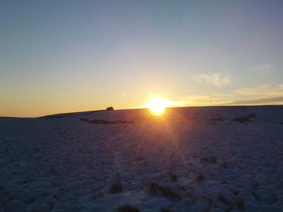
The cup-marked Winter Hill Stone a few hundred yards to the northeast, which I previously thought aligned with this site around winter solstice, but which happens to be a few degrees of arc off-line, would have indicated a very early mythic relationship, but this thought may now have to be put to bed.  I’ve not checked whether the winter solstice alignment shown in the photo below (with the Hitching Stone being shown on the near-horizon as the sun rose on winter solstice, 2010, from Winter Hill Stone) would have been closer in neolithic times or not.  Summat to check out sometime in the future maybe…

This aside, there is little doubt that this was an important sacred site to our ancestors.

Folklore

Winter Solstice sunrise, 2010 (from Winter Hill Stone)

Legend has it that the Hitching Stone used to sit on Ilkley Moor. But it was outside the rocky house of a great witch who, fed up by the constant intrusion the boulder made to her life, tried all sorts of ways to move it, but without success. So one day, using magick, she stuck her wand (or broomstick) into the very rock itself and threw it several miles from one side of the valley to the other until it landed where it still sits, on Keighley Moor.

A variation on the same tale tells that she pushed it up the hill from the Aire valley bottom. The “hole” running through the stone is supposed to be where our old witch shoved her broomstick!

References:

  1. Bennett, Paul, The Old Stones of Elmet, Capall Bann: Milverton 2001.
  2. Gray, Johnnie, Through Airedale form Goole to Malham, G.F. Sewell: Bradford 1891.
  3. Keighley, William, Keighley, Past and Present, R. Aked: Keighley 1858.
  4. Wood, Eric, Cowling: A Moorland Parish, Cowling Local History Society 1980.

© Paul Bennett, The Northern Antiquarian


Devil’s Stone, Addlebrough, Bainbridge, North Yorkshire

Legendary Rock:  OS Grid Reference – SD 943 880

Getting Here

From the small town of Bainbridge, head south down the Carpley Green Road. Less than a mile before the end, look to the west-facing slope of Addlebrough Hill and this huge Devil’s Stone can be seen resting halfway up the slope.

Archaeology & History

Devil's Stone, Addlebrough
Devil’s Stone, Addlebrough

One of the legends of this place suggested there might be cup-and-ring markings on the stone, but the curious markings on top of the rock seem to be natural.  It’s a superb stone though, dropped here no doubt by some great glacier as it retreated north, in ages truly olde…

There’s a lot of archaeology round here that aint in the books.  We’ve come across some intriguing stuff of late, which you’ll read about soon enough.

Folklore

One legend tells that long ago Addlebrough was the home of a great unnamed giant — but a friendly giant by all acounts.  However, one day the devil turned up and wanted possession of the giant’s hill and so a fierce row broke out between them.  Perched on the top of the crag — which is the rough ridge to the west of here — the giant who lived here hurled huge boulders down at the devil, but they fell short and landed at the side of Lake Semerwater (itself an important spot in local prehistory).  In return, Old Nick himself began throwing boulders back — and one of those which the devil threw landed here, halfway up the western flank of Addlebrough Hill (a couple of the large granite boulders which the giant threw can be seen on the edge of Semerwater and are known as the Carlow and Mermaid stones).  Hence it’s name of the Devil’s Stone!

In Edmund Bogg’s Richmondshire (1908), he told how, “the curious markings on (the Devil’s Stone) are accounted due to the pressure of the devil’s fingers” which were caused when he threw this giant stone from somewhere to here.

This is a theme we find at countless other stone sites, i.e. the Devil burning holes into rock — and in some cases these devil’s “fingerprints” have turned out to be prehistoric cup-markings.  Such tales relate to the pre-christian Creation Myth of a place and would, before the “devil” was supplanted onto a site, have had wider significance in the landscape as a whole, in a manner known to the local people.  Devils usually replaced legendary giants, or hero-figures, who created the land in primordial times according to the myths of our ancient ancestors.  A greater examination of the nearby sites in association with the folklore of the region would no doubt be quite profitable…

References:

  1. Bogg, Edmund, Richmondshire, James Miles: Leeds 1908.

© Paul Bennett, The Northern Antiquarian


Devil’s Apronful, Appletreewick, North Yorkshire

Cairn:  OS Grid Reference – SE 07485 59355

Getting Here

Devils Apronful on 1853 map

An excellent spot with fantastic views. There’s many ways to approach the place, but a good one is from the roadside by Howgill, then following the track uphill until you reach the moor, then head towards the spectacular and legendary, Simon’s Seat (which folklore ascribes to be named after the great druid, Simon Magus). You’ll pass an old Grey Stone (two large rocks) from which you can espy the old tomb if you stand on top of ’em. Keep walking uphill and it’s about 100 yards off the footpath to your right. A large boulder is nestled just beneath the tomb itself, which stands out on a ridge.

Archaeology & History

When Harry Speight visited here (1900) he described it as being 40 yards in circumference. He also described “an upright stone below the cairn” with apparent cup-markings on the west-side.  I’m not quite sure where this has got to – but the site has shrunk somewhat since Speight’s day.  It’s only about 20 feet across now, and the middle of it has been hollowed into a grouse-shooting butt for the toffs!

About 100 yards southeast (towards the Truckle Stones) are the remains of some neolithic walling in a straight line.

Folklore

One of many old tombs in our northern hills said to have been created by the devil who, as usual, accidentally dropped some stones he was carrying. The old folklorist Thomas Parkinson (1888) said the following of this place:

“The Apronful of Stones is a group of rocks heaped together in delightful confusion, their disorder and name being thus explained:  Once upon a time—whether when he built the bridge over the valley, or at some other time, the record saith not—the Devil was determined to fill up the ravine, or gill, of the Dibble. For this purpose he was carrying these enormous crags in his apron, when, too intent upon his object to properly observe where he placed his feet, he caught with one foot upon the top of Nursa Knott, and, stumbling, the strings of the apron broke, and the contents were thrown upon the ground as they now appear. It is also said of them that if any of them, even now, were to be removed, they would certainly be brought back to their original place during the succeeding night.”

Another legend tells that the Devil’s Apronful is also the grave of some local unnamed hero.

References:

  1. Parkinson, Thomas, Yorkshire Legends and Traditions – volume 1, Elliott Stock: London 1888.
  2. Speight, Harry, Upper Wharfedale, Elliott Stock: London 1900.

© Paul Bennett, The Northern Antiquarian