St. Sennen’s Well, Sennen Cove, Cornwall

Holy Well (lost):  OS Grid reference – SW 3550 2626

Archaeology & History

The springs of Chapel Idne

Highlighted on the 1888 Ordnance Survey map of Sennen Cove are the remains of Chapel Idne, just above the coast.  Across the road from the chapel on its south-side, and also next to an old inn to its immediate west, springs of water are shown and it would seem more than likely that one of these two would have been the forgotten holy well of Sennen that was described, albeit briefly, in the great Mr Blight’s (1861) literary tour of the area.  He told us that:

“At Sennen Cove was an ancient chapel, called by the people Chapel Idne, the “narrow chapel” being forty-five feet long and fifteen feet wide.  It is now converted into a dwelling. Tradition says it was founded by one Lord of Goonhilly, who possessed dome portion of the land of Lyonesse.  There was a holy well of some repute here also.”

The waters of St. Sennen’s Well were used in an act of ceremonial magick in the Arthurian tale known as the Battle of Vellan-druchar, as told in Robert Hunt’s (1865) great Romances.  An attempted invasion by the Danes was met with by Arthur and nine other kings and the foreigners were slaughtered.

“A few had been left in charge of the ships, and as soon as they learned the fate of their brethren, they hastened to escape, hoping to return to their own northern land. A holy woman, whose name has not been preserved to us, “brought home a west wind” by emptying the Holy Well against the hill, and sweeping the church from the door to the altar.  Thus they were prevented from escaping, and were all thrown by the force of a storm and the currents either on the rocky shore, or on the sands, where they were left high and dry.  It happened on the occasion of an extraordinary spring-tide, which was yet increased by the wind, so that the ships lay high up on the rocks, or on the sands; and for years the birds built their nests in the masts and rigging.

Thus perished the last army of Danes who dared to land upon our western shores.

King Arthur and the nine kings pledged each other in the holy water from St Sennen’s Well, they returned thanks for their victory in St Sennen’s Chapel, and dined that day on the Table-men.

Merlin, the prophet, was amongst the host, and the feast being ended, he was seized with the prophetic afflatus, and in the hearing of all the host proclaimed–

“The northmen wild once more shall land,
And leave their bones on Escol’s sand.
The soil of Vellan-Druchar’s plain
Again shall take a sanguine stain;
And o’er the mill-wheel roll a flood
Of Danish mix’d with Cornish blood.
When thus the vanquish’d find no tomb,
Expect the dreadful day of doom.”

References:

  1. Blight, J.T., A Week at the Land’s End, Longmans Green: London 1861.
  2. Hunt, Robert, Popular Romances of the West of England, 1865.
  3. Straffon, Cheryl, “Chapel Idne and the Holy Well,” in Meym Mamvro no.34, 1997.
  4. Weatherhill, Craig, “A Guide to Holy Wells and Celebrated Springs in West Penwith,” in Meym Mamvro no.4, 1997.

Acknowledgements:  Big thanks for use of the early edition OS-map in this site profile, Reproduced with the kind permission of the National Library of Scotland

© Paul BennettThe Northern Antiquarian

Maiden’s Well, Launceston, Cornwall

Holy Well (destroyed):  OS Grid reference – SX 3285 8477

Archaeology & History

Site of well on 1884 map

Very little is known about this holy well on the north-western side of town that was apparently destroyed sometime in the 19th century; for when the Ordnance Survey lads visited here in 1882, they found no running water but only the location of where it had been and they indicated this on their 1884 map of the area, marked as “Site of.”

It was first mentioned in a short topographical notice in 1582, which told that the “Magden Well in the Quarrie Haye”—along with another well—was “found to be in decay.” (Peter 1885)  Then, when the Ordnance Survey lads resurveyed the area again in 1951, once more they could find no trace of it.

References:

  1. Peter, Richard, The Histories of Launceston and Dunheved, W. Brendon: Plymouth 1885.

Acknowledgements:  Big thanks for use of the early edition OS-map in this site profile, Reproduced with the kind permission of the National Library of Scotland

© Paul BennettThe Northern Antiquarian

Holy Well, Lawhitton, Cornwall

Holy Well:  OS Grid reference – SX 3546 8252

Archaeology & History

Site shown on 1882 OS-map

Highlighted on the 1882 OS-map several hundred yards north of St. Michael’s church, this site seems to have fallen back to Earth as no remains of it have been found in recent visits.  It was described in Charles Henderson’s (1914) notes as the “holy well at Barton Farm”, and was visited by J. Meyrick (1982) in April of 1980, who told that it could be found by taking “the track immediately east of Lawhitton church which runs through the farm of Mr Lancaster…  After going through the yard proceed ¼ mile down track to the valley where you reach a stream and the Well is on the right.”  It was sought after by Cheryl Straffon (1998) but following her visit to find the Well she told that “there was nothing now to see except a kind of natural basin by the small bridge.”

References:

  1. Henderson, Charles, Notebooks of Parochial Antiquities, Unpublished MS 1914.
  2. Meyrick, J., A Pilgrims Guide to the Holy Wells of Cornwall, Falmouth 1982.
  3. Straffon, Cheryl, Fentynyow Kernow: In Search of Cornwall’s Holy Wells, Meyn Mamvro: Penzance 1998.

Acknowledgements:  Big thanks for use of the early edition OS-map in this site profile, Reproduced with the kind permission of the National Library of Scotland

© Paul BennettThe Northern Antiquarian

St. Martin’s Well, Looe, Cornwall

Holy Well:  OS Grid Reference – SX 2569 5407

Archaeology & History

St Martins Well on 1888 map

An early dedication to the St Martin of this well is from the 13th century, when referring to the “church of sanctus Martinus” in 1282, whose building is a half-mile to the north.  The well itself is located on the old parish boundary, on the footpath today known as the North View.

In earlier days, the water from this site came “flowing out of a rock” giving birth to St Martin’s stream (Quiller-Couch, 1894).  “It was much used by the villagers,” they wrote, “because of the excellent quality of the water; now it is covered in with an ordinary wooden lid, and is used to supply the town of Looe with water.”

Things hadn’t changed when Mr Lane-Davies (1970) visited the place, who was far from pleased at its status.  “The spring,” he told, “has been enclosed in an ugly shed and the water piped away.”

Despite this, when Meyrick (1982) came here, he thought the site had “a romantic and grotto-like air” to it, but he was equally displeased by barbed wire preventing folk from easily accessing the waters and “spoilt by a certain amount of rubbish.”  Unfortunately due to a dreadful accident here in 1993, when a young child fell into the waters and drowned, the site is now completely enclosed by railings to prevent this happening to anyone else.

References:

  1. Bond, Thomas, Topographical and Historical Sketches of the Boroughs of East and West Looe, J. Nichols: London 1823.
  2. Lane-Davies, A., Holy Wells of Cornwall, FOCS: St Ives 1970.
  3. Meyrick, J., A Pilgrims Guide to the Holy Wells of Cornwall, Falmouth 1982.
  4. Quiller-Couch, M. & L., Ancient and Holy Wells of Cornwall, C.J. Clark: London 1894.
  5. Straffon, Cheryl, Fentynyow Kernow: In Search of Cornwall’s Holy Wells, Meyn Mamvro: Penzance 1998.

© Paul BennettThe Northern Antiquarian

Holy Well, Trelawne, Cornwall

Holy Well (lost?):  OS Grid reference – SX 2258 5311

Archaeology & History

This spot is where an old field-name has preserved the memory of an all-but-forgotten holy well, known as the “Holywell Ground.”  Although it may have fallen back to Earth, there are two possible spots regarding its position: i) a spring that was marked on the 1882 OS-map at SX 2258 5315, and ii) a “Well” that’s shown on the recent OS-maps (SX 2257 5306).  Hence, the grid-reference I’ve given to this place is the halfway spot between them both. (it has to be pointed out that the “well” on recent maps occurs right next to an old quarry, which are well known to bring forth water sources that were previously deep underground)  Whether or not Sclerder Abbey—about 400 yards west of here and only built in 1843—had anything to do with the sanctifying this well, I do not know.

© Paul BennettThe Northern Antiquarian

Wishing Well, Bone Valley, Madron, Cornwall

Sacred Well (lost):  OS Grid reference – SW 4614 3259

Archaeology & History

It’s difficult to know what to make of this site: whether it was merely a healing well or whether it possessed greater esoteric functions.  In all likelihood it was the latter as many so-called “wishing wells” in earlier centuries possessed oracular attributes.  It’s also difficult to work out precisely where this well happened to be, as we know little about it apart from the singular reference of Quiller-Couch (1894), who told simply that,

“There was also a wishing-well in the Bone Valley; it is now only a small stream, and is not used for purposes of divination.”

Hidden spring on 1878 map
Line of wells on 1908 map

There were a number of wells along the Bone Valley road highlighted on the early OS-map, all of which may have been known to Quiller-Couch at the time, three of which appeared to have streams emerging from them back then: one just above Bosoljack (SW 4556 3319) and one below it (SW 4571 3292), each just off the roadside; but then a slightly more enticing one is hidden a little further down the lane and up the tinier lane to Higher Boskinning, in the trees on the right (east).  Shown on the first OS-map as a simple “spring”, a small stream runs from it and then into the larger Bone Valley Brook which runs towards Penzance.  The solace and quietude of this spot would seem much more favourable than the other two…. but my impressions may be wrong.  It would be good if someone could find this old place…

References:

  1. Quiller-Couch, M. & L., The Holy Wells of Cornwall, C.J. Clark: London 1894.
  2. Russell, Vivien, West Penwith Survey, Cornwall Archaeological Society 1971.

Acknowledgements:  Big thanks for use of the early edition OS-map in this site profile, Reproduced with the kind permission of the National Library of Scotland

© Paul BennettThe Northern Antiquarian

Chapel Well, Botrea, Sancreed, Cornwall

Holy Well (lost):  OS Grid reference – SW 4025 3062

Archaeology & History

Just over a mile northwest of the superb Sancreed Well, we find documentary evidence from 1778 recording the field-name of Chapel Well Close here, although there seems to be no remaining spring or well and nothing is shown on the early OS-maps.  Official records define it as a “medieval well” and speculate that it may have been associated with the nearby Boscence Chapel and possibly dedicated to St. Winwaloe.

References:

  1. Anon., The Church and Parish of Sancreed in the County of Cornwall, Brewer: Sancreed c.1960.

© Paul BennettThe Northern Antiquarian

Glastonbury Well, Sunny Corner, Truro, Cornwall

Holy Well (lost?):  OS Grid Reference – SW 837 434

Archaeology & History

There’s a minor discrepancy of opinion as to the exact location of this site, so I’ve chosen to go right in-between the positions cited by Leggat (1987): SW 836 433, and Meyrick (1982): SW 838 434.

The site was mentioned by Charles Henderson, who told that around the year 1750 there was a medicinal well at Sunny Corner, known as “Glastonbury Well”.  Its waters had the ability to “cure all disorders,” but its reputation was apparently short-lived, which would suggest that its fame beyond local villagers was concurrent to the rise of Spa Wells amongst the upper- classes at that time.

In the Leggats’ (1987) survey, no locals they spoke with had ever heard of the place; but that they “found a spring halfway up the lane adjacent to Sunnyside House which had been used in the past from time immemorial as a domestic water supply to a scattering of local cottages” and wondered if this might have been the long long Glastonbury Well…

References:

  1. AdamsJ.H., “The Mediaeval Chapels of Cornwall,” in Journal Royal Institution of Cornwall, volume 3 (new series), 1957. 
  2. Henderson, Charles, One Hundred and Nine Parishes of the Four Western Hundreds of Cornwall, Oscar Black: Truro 1955.
  3. Leggat, P.O. & D.V., The Healing Wells: Cornish Cults and Customs, Dyllansow Truran: Redruth 1987.
  4. Meyrick, J., A Pilgrims Guide to the Holy Wells of Cornwall, Falmouth 1982.

© Paul BennettThe Northern Antiquarian

Holy Well, Gunwalloe, Cornwall

Holy Well (lost):  OS Grid Reference – SW 6602 2053

Archaeology & History

The old church at this headland just above the sea was, said Padel (1988), dedicated to Saint Gunwalloe or Winwalloe in 1332 and is thought to have been the character (a hermit by all accounts) who deemed this well to be ‘holy’.  In Alfred Cummings (1875) history of Gunwalloe parish, he devotes a short but singular chapter to this holy well which, according to most accounts, has fallen back to Earth.  It was found, said Cummings, “close to the church porch, only a few feet over the precipitous rock…and (was) doubtless the resort in former days of many a lad and maiden.”

Yet even in his day, he lamented its loss, telling that.

“The spring that once bubbled up in its rocky basin is no longer there; sand and stones fill up the well at each high tide, and though occasionally cleaned out for the satisfaction of the wayfarer’s curiosity is yet only an imperfect semblance of its former self.”

Yet remnants of practices and traditions of the well were thankfully remembered:

Gunwalloe church in 1885

“That Gunwalloe was considered by the country folk a well of some importance there can be little doubt, for one day in the year, which was called Gunwalloe Day, was set apart for cleaning out this holy well — it was quite at a different time of year to this parish feast — and now only remembered by two old men out of the whole population of the place.

“They fix the time in their memories as the period of tilling barley, for they recollect that on this Gunwalloe Day it was the custom for the men to mend all the cliff roads (doubtless these were useful in days of smuggling when a successful run was a desirable thing), and so strictly was it kept that, if any were found labouring in the fields, a party would go and take them by force, and press them into the service of the holiday makers, who, having mended the roads and cleared the holy well at Gunwalloe, wound up the day with merriment and revelry.”

Such practices are long since gone of course and, so most modern accounts would tell us, the holy well with it.  But when J. Meyrick (1982) came looking for the site on the summer solstice of 1980, he seemed a little more fortunate than his predecessors.  Located just a few yards from the detached church tower, he spoke with a

“Mrs Wilson, a churchwarden (who) told me that in heavy rain the tower continues to be flooded so the spring is still somewhere about, and curiously enough by the stile to the beach is a small granite trough with rainwater put there by someone no doubt in lieu of the Well and who is to say that the water is not holy!  The stream across the dune still meanders a few feet beneath the tower and into this the water from the well would have run, but there seems now no sign of an originating spring in the rocks around.”

Folklore

The church itself possesses a folktale found up and down the land.  “It is said,” wrote Blight (1885),

“that the builders intended to erect the church on higher ground, nearer the centre of the parish, at Hingey; but as fast as materials were brought to the place they were, by some mysterious agency, removed during the night to the present site.  And here the church was built, it being found useless to contend with a supernatural power.”

The supernatural agencies that are nearly always responsible for such actions tend to be the devil, fairies or other types of little-people.

References:

  1. Blight, J.T., Churches of West Cornwall, Parker: London 1885.
  2. Cummings, Alfred H., The Churches and Antiquities of Cury and Gunwalloe, W. Lake: Truro 1875.
  3. Meyrick, J., A Pilgrim’s Guide to the Holy Wells of Cornwall, J. Meyrick: Falmouth 1982.
  4. Padel, O.J., Cornish Place-Names, Alison Hodge: Penzance 1988.
  5. Quiller-Couch, M. & L., Ancient and Holy Wells of Cornwall, C.J. Clark: London 1894.

© Paul BennettThe Northern Antiquarian

Boskenna Cross, St Buryan, Cornwall

Wayside Cross:  OS Grid Reference – SW 42579 24266

Also Known as:

  1. Historic England Grade II Listed Building No. 1007955

Boskenna Cross on 1887 map

Getting Here

Travelling along the B3315 from Penzance to Lands End, the Cross is on the south side of the road at the junction with the minor road to St Buryan, past the Merry Maidens stone circle.

Archaeology & History

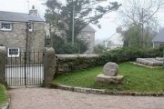
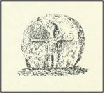
Arthur Langdon (1896), in his magnum opus on Cornish Crosses, describes this wheel-headed wayside cross:

Sketch from Langdon’s 1896 book

The only ancient part of the monument is the little cross at the top, which is mounted on a base made up of an extraordinary collection of apparently disused circular granite stones. Immediately beneath the cross is a cylindrical piece, the upper edge of which is roughly rounded off. Beneath this comes a short drum, about two inches wider than the piece above and nine inches deep. The next two stones are much wider but not so deep as the last, the bottom one consisting of the lower portion of an old cider-press, with its surrounding channel and lip !

Its roadside position.

There is a good deal to admire in the feeling which prompted this effort to once and for all preserve so ancient a relic, and the care bestowed in the erection of this curious substructure goes far to remove its incongruity.

Front — The figure of our Lord here sculptured is quite the best example in which He is represented wearing the tunic; the expanded sleeves are especially apparent, as well as the outline of the garment above the knees. The feet are very large, and turn outwards at right angles.

The Crucifixion face

Back — On the head is a cross with expanded limbs, flush with the surface of the stone. The four triangular sinkings, or recesses, which form the background are not of uniform size, the lower being considerably larger than those above, thus making the lower limb the longest. The inner portion of each sinking is raised, forming bosses in low relief.

Dimensions — Total height of the monument, 6 ft. 10 in; height of the cross, 2 ft. 4 in; width of head, 1 ft. 8 in; width of shaft, 12½ in.

The cross has had a chequered history. It is not known when it was demolished.  Langdon, once more, takes up the story:

The opposite face.

Mr. J. H. Johns, landlord of the “King’s Arms”, St. Buryan, informed me of the circumstances connected with the discovery of this cross. It appears that formerly one of the angles at the intersection of these roads was so sharp and awkward for traffic that, in 1869, the local authorities decided to ease this corner by rounding off the hedge, which was then about ten feet thick. Mr. Johns’ father was one of the men employed on this work, and shortly after commencing he found the cross buried in the hedge. By the advice of His Honour Charles Dacres Bevan, County Court Judge of Cornwall, and then residing at Boskenna Mansion House, the cross was erected on the triangular piece of grass in the middle of the roads, a spot on which it is extremely likely it originally stood.

Side view from the east.

In 1941 and 1942, the Cross was demolished by road vehicles, whereupon the council removed it to its present roadside position. It was again hit by a vehicle in 1992. And in 2002 there was another incident, reported by Meyn Mamvro:

..In February the top of the cross was found lying by the roadside. It is not known whether this was the result of deliberate vandalism or a road traffic accident, but local village witch Cassandra Latham acted quickly in alerting Cornwall Archaeological Unit, who took it away for repair and restoration…

References:

  1. Langdon, Arthur G., Old Cornish Crosses, Truro, Joseph Pollard, 1896.
  2. Langdon, Andrew, Stone Crosses in West Penwith, The Federation of Old Cornwall Societies, 1997.
  3. Meyn Mamvro, No 49, Autumn 2002, p. 4

© Paul T. Hornby 2018