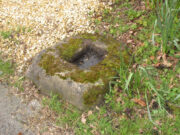
St. Bennet’s Well, Cromarty, Ross & Cromarty

Holy Well:  OS Grid Reference – NH 7923 6502

Archaeology & History

St Bennets Well 1880 map

An old church dedicated to St Bennet once existed on the hill above where this spring of water emerges, but little is now left of the building.  Thankfully the holy well hasn’t quite followed in the footsteps of the church.  Miss Riley (1935) told us that it can be found “near the high-water mark…situated at the foot of a beautiful little glen which runs inland from the coast” – and from all accounts it is still there.

Shown on the 1880 OS-map of the region, the dedication to St Bennet is obscure.  Mr Pullan (1927) suggested it derived from the 6th century St Benedict of Nursia, but this is improbable.  The Royal Commission lads thought it more likely derived from “a Celtic foundation.”

Folklore

The earliest description I’ve found regarding the traditions surrounding this well are by Hugh Miller (1835).  He wrote:

“It is not yet twenty years since a thorn-bush, which formed a little canopy over the spring of St. Bennet, used to be covered anew every season with little pieces of rag, left on it as offerings to the saint, by sick people who came to drink of the water.”

But the tradition didn’t die out, as evidenced by a short article by Miss M.D. Riley (1935) in Antiquity journal where she gave us further valuable information about its folk history, saying:

“In order to insure the fulfilment of the wish it is essential that the wisher should drink the water and leave something of his personal attire.  When the writer visited the spot there was a heterogeneous collection of ‘rags’ hanging on the branches.

“Mr Francis Scott tells me that the site is locally supposed to be the place of judgement.  It is close to the ruins of St Bennet’s Chapel and the ground is said to be cursed as it was stoeln by the Church. Even at the present day the owner has to provide each year at Christmas-tide 8 cwt of oatmeal free for the poor of the parish.  This has been operative since 1630 and though the owner has tested the matter in the highest court of law in Scotland, his appeal was not allowed.”

The tradition of giving offerings to the spirit of this well was still recorded in 1966.

References:

  1. Hiley, M.D., “Rag-Wells,” in Antiquity, volume 9:4, December 1935.
  2. Innies, Cosmo, Origines Parochiales – volume 2:2, W.H. Lizars: Edinburgh 1855.
  3. Miller, Hugh, Scenes and Legends of the North of Scotland; the Traditional History of Cromarty, William Nimmo: Edinburgh 1835.
  4. Morris, Ruth & Frank, Scottish Healing Wells, Alethea: Sandy 1982.
  5. Pullan, L., The Banner of St Boniface, London 1927.

© Paul BennettThe Northern Antiquarian

St. Serf’s Well, Crieff, Perthshire

Holy Well (lost):  OS Grid Reference – NN 8457 2323

Archaeology & History

St Serfs Well on 1866 map

A mile to the west side of Crieff, in the grounds of the 18th century mansion known as Ochtertyre House, could once be seen the little-known sacred well of St Serf.  Sadly its waters seem to have disappeared beneath the rising waters of the loch known as St Serf’s Waters—which is a pity, as the place was of importance in the annual traditions of the local people, who left offerings to the spirit of the place, as was common in days of olde.  It was described in Mr Porteous’ (1822) account of Monzievaird parish, in which he told that,

“Nigh to this place is St Serf’s Well, and the moor whereon St Serf’s market is held.  He was the tutelary saint of the parish of Monivaird.  This well is a plentiful spring of water.  About sixty years ago, our people were wont, on Lammas day, to go and drink it, leaving white stones, spoons, or rags, which they brought with them; but nothing except the white stones now appear, this superstitious practice being quite in oblivion.  It has been useful in a strangury, as any other very cold water would be; for a patient, taking a tub full of it immediately from the well, plunging his arms into it, which were bare to the elbows, was cured.

“St Serf’s fair is still kept on the 11th of July, where Highland horses, linen cloth, etc., both from the south and north, are sold.”

Although the well is deemed to be ‘lost’, it is possible that its waters might be seen after a good drought.  Please let us know if that happens.

Folklore

St. Serf was said to have been a hermit and tutor of the more renowned St. Mungo.

References:

  1. Morris, Ruth & Frank, Scottish Healing Wells, Alethea: Sandy 1982.
  2. Porteous, A., “Extracts from a History of the Parishes of Monivaird and Strowan“, in Archaeologia Scotica, volume 2, 1822.

Acknowledgements:  Big thanks for use of the 1st edition OS-map in this site profile, Reproduced with the kind permission of the National Library of Scotland

© Paul BennettThe Northern Antiquarian


St James’ Cross, Barton-upon-Humber, Lincolnshire

Cross (destroyed):  OS Grid reference – TA 0424 2064

Archaeology & History

This long lost wayside cross was described in various local records from 1621 upwards.  In the definitive place-name survey of this area, Kenneth Cameron (1991) told us that this was,

“A medieval cross dedicated to St James, situated at the point where the Thornton and Burnham roads meet… Mr R. Newton comments, “said to have replaced a wayside shrine.  The foundations of the shrine were exposed when the Home Guard dug a defensive trench there at the beginning of the last war.  Foundations destroyed by a bomb.””

References:

  1. Cameron, Kenneth, The Place-Names of Lincolnshire – volume 2, EPNS: Nottingham 1991.

© Paul BennettThe Northern Antiquarian

Dawe’s Cross, Cambridge, Cambridgeshire

Cross (destroyed):  OS Grid Reference – TL 455 578

Archaeology & History

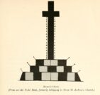
This is one of several medieval stone crosses in Cambridge that were destroyed several centuries ago.  This particular one was erected on a three-stepped stone base at the old crossroads where, today, the modern A1307 of Regent Street meets the A603 Lensfield Road.  It was described in an old Field Book of 1575 as standing being beside an old poplar tree, long gone.  Mr H.P. Stokes (1915) gave us a short account of the site, telling:

“In describing the lane called “Deepway” between the London Road and the Hadstock Way and known as “King’s Lane” from the latter road to Hinton Way, mention was made of a Cross (called Dawe’s Cross) which stood at what is now known as Hyde Park Corner.  Dawe’s Cross is often mentioned in ancient deeds, and in an old Field Book, which formerly belonged to the vestry of the Church of St Andrew the Great, there was a most interesting representation of it.  This is here reproduced…from a copy in the celebrated Bowtell MSS.”

The cross stood along one of Alfred Watkins’ (1932) “archaic tracks”, or leys, in this area—although he wasn’t aware of its existence.

References:

  1. Stokes, H.P., Outside the Barnwell Gate, Cambridge Antiquarian Society 1915.
  2. Watkins, Alfred, Archaic Tracks round Cambridge, Simpkin Marshall: London 1932.

© Paul BennettThe Northern Antiquarian

St Ellen’s Well, Harrisend Fell, Scorton, Lancashire

Holy Well: OS Reference – SD 53683 50975

Also Known as:

  1. St Ellin’s Well

Getting Here

The Well on the 1846 Map

Approaching the site from the north, walk along the Lane Head track, and along the path south-eastwards, then turn right onto the main footpath until coming to the stream. Follow the stream up the fell to the large clump of reeds, then follow your ears until you locate the spring! Or you can approach it along the main footpath from the Oakenclough – Galgate road. The well and the path to it
are on access land.

Archaeology & History

Fortunately recorded by the Ordnance Survey on their 1846 6″ map Lancashire XL, the story of St Ellen’s Well was taken up sixty years later by local holy wells historian Henry Taylor (1906):

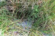
Listen for the spring in the reeds

“The site of this holy well is marked on the ordnance map at a lonely spot on Harris Fell, five hundred feet above the sea-level, four and a half miles in a north-easterly direction from the town of Garstang.

“Mr. A. King has kindly examined the site.  He writes, 4th August, 1902: “We had no difficulty in locating the spot…. There is no outward indication of the place being used for curative means, and there is no stonework at all. It is a beautifully cold spring which is at the side of ‘Bonny Pad’, a pathway leading across the moor from Harris End, and it was grown around with rushes….  All I can glean about it is that one of the oldest inhabitants, when asked if he knew of it, replied, ‘It will be th’ holy well, you mean.'”

The original dedication of this remote holy well was clearly to St. Helen, and its presence next to the Bonny Pad or path may indicate a pre-Christian dedication to a local cognate of the Celtic Elen Luyddog, Elen of the hosts or ways.  The Bonny Pad is shown but not not named on the 1846 map, and follows a broadly southwest to northeast direction from Harris End (again not named on the 1846 map) up to Grizedale Head on the southern edge of the Catshaw Vaccary.  It was perhaps an ancient route used by farmers to take their animals up onto the fell for the summer, and return them to the lowlands in the autumn.

Bubbling away at source

The western portion of Bonny Pad is not shown on the modern map and St Ellen’s Well is not marked, and both have it seems passed out of local memory.  An elderly farmer I encountered on my way up to the fell had never heard of the Well.

It is certainly worth the walk if only for the delightful sound of this powerfully flowing spring, the water is pure and cold, and it commands a fine view over the Lancashire plain to the coast.

References:

  1. Taylor, Henry, The Ancient Crosses and Holy Wells of Lancashire, Sherratt & Hughes: Manchester 1906.
  2. Wise, Caroline, “Elen of the Roads of Country and Town”, in Finding Elen – The Quest for Elen of the Ways, edited by Caroline Wise, Eala Press: London 2015.

© Paul T. Hornby, 2020

Bradshaw Cross, Long Lane, Nether Wyresdale, Lancashire.

Wayside cross: OS Reference – SD 52474 51414

Also Known as :

  1. Historic England Grade II Listed Building No. 1163927 

Getting Here

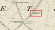
Cross shown on 1846 map

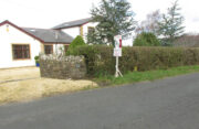
Follow Long Lane northwards from Scorton, over the crossroads at Crosshill Four Lane Ends, and the cross base will be found at the road edge immediately to the right of the driveway of ‘Sandalwood’ on the left hand side of the road.

Archaeology & History

Described in the Historic Buildings listing citation as:

“Cross base, probably mediaeval. A sandstone boulder, roughly rectangular, with rectangular socket.”

Cross base at the roadside
‘A sandstone boulder, roughly rectangular’

The base of one of the numerous mediaeval wayside crosses that once adorned this part of Lancashire. So what happened to the cross? It’s possible that it was wilfully destroyed in the early nineteenth century as we have a likely culprit in the person of the Reverend Richard ‘Cross Smasher’ Wilkinson (c.1791 – 1823), Curate of Whitechapel, who took it upon himself to destroy the symbol of his religion wheresoever he could find it.

Immediately to the north west of the Cross is Cross Hill.  The cross itself was probably a waymarker on the road over Harrisend Fell from Oakenclough, and Bradshaw may be the name of the locality, there being a Bradshaw Bridge just outside Street to the north west, while the 1846 6-inch OS map records a ‘Bradshaw Smithy’ on the same road.

Note: More has been recorded about Wilkinson in the profile of Stump Cross, near Goosnargh.

Reference:

  1. Taylor, Henry, The Ancient Crosses and Holy Wells of Lancashire, Sherratt and Hughes, Manchester, 1906

© Paul T Hornby, The Northern Antiquarian, 2020

Clach an Eolas, St Kilda, Outer Hebrides

Legendary Stone:  OS Grid Reference – NF 101 996?

Also Known as:

  1. Stone of Knowledge

Archaeology & History

This stone has very similar qualities to the one found upon Mullach-geal, ⅔ of a mile to the west, as a place where ritual magick was performed.  And, just like the Mullach-geal stone, we only have an approximate position of its whereabouts: “behind the village”, as Mr Sands (1878) said.  The same words were used by other St Kildan writers when it came to describing the whereabouts of Tobar Childe, so we must assume it to be reasonably close to the old well.

Folklore

Mr Sands seems to be the first person to write about it, telling us,

“At the back of the village is a stone, which does not differ in external appearance from the numerous stones scattered around, but which was supposed to possess magical properties.  It is called Clach an Eolas, or Stone of Knowledge.  If any one stood on it on the first day of the quarter, he became endowed with the second sight — could “look into the seeds of Time,” and foretell all that was to happen during the rest of the quarter.  Such an institution must have been of great value in Hirta, where news are so scanty.  To test its powers I stood on it on the first day of Spring (old style) in the present year, but must acknowledge that I saw nothing, except two or three women laden with peats, who were smiling at my credulity.”

Charles MacLean (1977) mentioned the stone a hundred years later, but seems to have just copied this earlier description.  Does anyone up there know its whereabouts?

References:

  1. MacLean, Charles, Island on the Edge of the World, Canongate: Edinburgh 1977.
  2. Sands, J., Out of the World; or Life in St. Kilda, Maclachlan & Stewart: Edinburgh 1878.

© Paul BennettThe Northern Antiquarian

Mullach-Geal Stone, St Kilda, Outer Hebrides

Legendary Rock:  OS Grid Reference – NF 092 996

Archaeology & History

This is a most intriguing site, whose exact location seems to have been forgotten.  It was first mentioned in Macaulay’s History of St Kilda (1764) as being one of four stone altars that the islanders used for worship.  Three of them were related to the early christian figure of St. Brendan, whose well and chapel remains are on the south-side of the island.  However, this fourth stone altar possessed a purely magickal and heathen function.  Macaulay initially gives the location as being “on top of a hill to the southwest” of St. Brendan’s chapel; but subsequently tells us it was upon “Mulach-geall” which is a mile NNW.  It was an important place to the people of Hirta and its exact position needs to be found and, hopefully, the altar still exists.

Folklore

Despite Macaulay’s conflicting directions of how to get here (a common feature of early writers), he wrote:

“I have already made mention of one St. Kilda altar, that in Brendans Chapel.  There are no less than four more in the island, of which three lie at considerable distances from the holy places.  There is one particularly on the top of a hill to the south-weft (sic), dedicated according to tradition to the God who presides over Seasons; The God of thunder, lightning, tempests and fair weather.  To avert the terrible judgments inflicted by this mighty Divinity, the ancient St. Kildians offered propitiatory sacrifices on this altar, sacrifices of different forts, much like the old Pagans, who offered a black sheep to Winter, or the Tempest, and a white one to the Spring…  The place where the people of this island, offered their victims to Taranis, is called Mulach-geall, that is to say, the White eminence or hill…”

More than a hundred years later, Seton (1878) made mention of it, but added no further details.

The invocation to Nature’s elements is something we find echoed at some sites further east, such as the Well of the North Wind on Iona and its compatriot Well of the South Wind.  At both these places, so-called ‘pagan’ rituals were used to both placate and invoke the gods and spirits of the wind.  This one on St Kilda possessed additional magickal prowess.  But where is it?  Have we lost it, or is it sleeping somewhere on the edge of Mullach-Geal…?

References:

  1. Macaulay, Kenneth, The History of St. Kilda; Containing a Description of This Remarkable Island; the Manners and Customs of the Inhabitants; the Religious and Pagan Antiquities There Found, T. Becket: London 1764.
  2. Seton, Gordon, St. Kilda – Past and Present, William Blackwood: Edinburgh 1878.

© Paul BennettThe Northern Antiquarian

Holy Well, Barking, Essex

Holy Well (destroyed):  OS Grid Reference – TQ 4421 8484

Archaeology & History

Barely 200 yards to the immediate southeastern edge of the once gigantic hillfort of Uphall Camp, could once be found an old holy well, last recorded it would seem in 1456.  The site was located just yards to the south of the old boundary that separates the parishes of Ilford and Dagenham.  Its location was described in the Victoria County History:

“A mile south of Ilford Bridge the Roding is joined by Loxford Water, a stream rising near Hog Hill, in Dagenham, and known in its upper reaches as Seven Kings Water. In 1456 the lower part of the stream was called Halywellbrooke.”

We also have an account in the Barking Abbey Rental, which told us there was “land in Longland at Halywellbrooke”, as well as “pasture lying at the northern head of Luzias land…near Halywell and…at Loxfordbrigge.” (Harte 2008)  It has long since been destroyed.

References:

  1. Harte, Jeremy, English Holy Wells – volume 2, Heart of Albion Press: Marlborough 2008.
  2. Powell, W.R. (ed.), A Victoria County History of Essex – volume 5, OUP: London 1966.

LinksHoly Well, Barking on The Megalithic Portal


St. Peter’s Well (2), Leeds, West Yorkshire

Holy Well (destroyed):  OS Grid Reference – SE 308 336

Archaeology & History

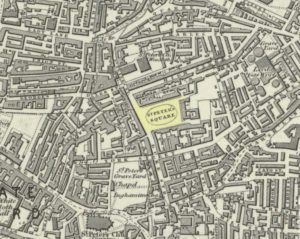
St Peters Well locale in 1852

This is one of three wells that were dedicated to St Peter in the Leeds district.  The first of them, near the city centre, was described by the northern antiquarian Ralph Thoresby (1715) as being in St. Peter’s Square—which has now been completely built over, but was situated “at the bottom or west end of High Street,” (Bonser 1974) about 50 yards west of the modern Quarry Hill buildings.  It was well known in the area in early times with a good curative reputation due seemingly to its sulphur content.  Mr Thoresby told that us, it

“is intensely cold and very beneficial for such as are afflicted with rheumatic pains, or weakness, rickets, etc, for which reason it is much frequented by such, who might otherwise have recourse to St. Mungus or Mongah, as it is more truly writ. This Spring, according to St Anselms Canon, which forbad a credulous attributing any reverence, or opinion of holiness to fountains…must either have been of great antiquity, or have had the bishop’s authority.”

Local folk of course, would have long known the goodness of this water supply long before any crude bishop.  The well either possessed a very large stone trough or it had been fashioned and added to by locals, as Thoresby reported “trying the cold bathing of St Peter’s.”  He took his youngest child there, Richard, to help him overcome an osteopathic ailment.  In his diary entry for April 8, 1709, he wrote:

“Was late at church, and fetched out by a messuage from the bone-setter (Smith, of Ardsley), who positively affirms that one part of the kneebone of my dear child Richard, has slipped out of its proper place; he set it right and bound it up; the Lord give a blessing to all endeavours!  We had made use of several before, who all affirmed that no bone was wrong, but that his limp proceeded rather from some weakness, which we were the rather induced to believe, because warm weather, and bathing in St. Peter’s Well, had set him perfectly on his feet without the least halting, only this severe Winter has made him worse than ever.”

It later became at least one of the water supplies for Maude’s Spa close by.  As usual with health-giving waters at this period in the evolving cities, money was to be made from them and local folk had to find their supplies from other sources.  St Peter’s Sulphur Baths (as it was called) were built on top of it in the 19th century and, said Bonser “flourished until the early years of the (20th) century.”

Although I can find no notices of annual celebrations or folklore here, St. Peter’s Day is June 29 — perhaps a late summer solstice site, though perhaps not.

It would be good if Leeds city council would at least put historical plaques in and around the city to inform people of the location of the many healing and holy wells that were once an integral part of the regions early history.  Tourists of various interest groups (from christian to pagan and beyond) would love to know more about their old sacred sites and spend their money in the city.

References:

  1. Atkinson, D.H., Ralph Thoresby, the Topographer – volume 1, Walker & Laycock: Leeds 1885.
  2. Baines, Edward, The Leeds Guide, E.Baines: Leeds 1806.
  3. Bonser, K.J., “Spas, Wells and Springs of Leeds,” in Publications Thoresby Society, 54:1, 1974.
  4. Harte, Jeremy, English Holy Wells – volume 2, Heart of Albion: Wymeswold 2008.
  5. NiBride, Feorag, The Wells and Springs of Leeds, Pagan Pratlle: Leeds 1994.
  6. Robinson, Percy, Relics of Old Leeds, P.Robinson: Leeds 1896.
  7. Smith, Andrea, ‘Holy Wells Around Leeds, Bradford & Pontefract,’ in Wakefield Historical Journal 9, 1982.
  8. Thoresby, Ralph, Ducatus Leodiensis, Maurice Atkins: London 1715.
  9. Whelan, Edna & Taylor, Ian, Yorkshire Holy Wells and Sacred Springs, Northern Lights 1989.

© Paul BennettThe Northern Antiquarian