Charles Pooley (1868) gave a somewhat vague description of this site, telling that, “there is authority for believing that at one time a Cross was set up in the village.” I can find no other reference to this monument which, I presume, has been destroyed. (the grid reference cited is an approximation near the centre of the village, where village crosses were usually located)
References:
Pooley, Charles, Notes on the Old Crosses of Gloucestershire, Longmans Green: London 1868.
Cross (destroyed): OS Grid Reference – SO 9674 1321
Archaeology & History
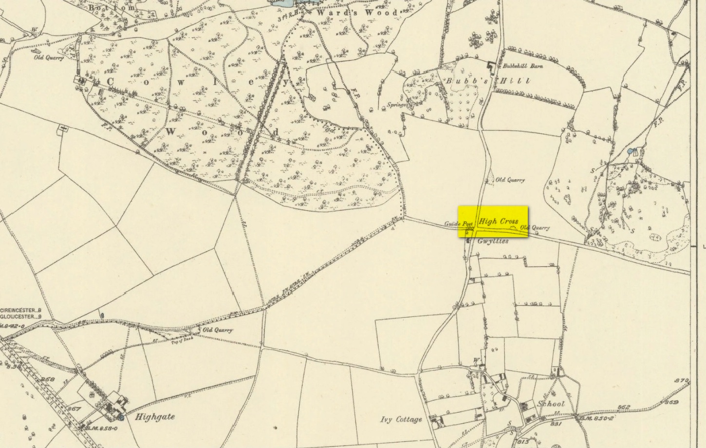
High Cross on 1883 map
First shown on a 1775 map of the region, this long-lost site is preserved in several place-names near the old crossroads a half-mile north of Elkstone village. It is mentioned, albeit briefly in Charles Pooley (1868) county survey, where he told that, “in former times a very handsome and lofty High Cross stood in this parish.” However, there’s the possibility that the name ‘High’ cross may here derive simply from a cross located at a high point in the landscape.
An old ‘Guide Post’ marked on the early Ordnance Survey map at the same spot has been suggested by Danny Sullivan—and not without good reason—to be a prehistoric standing stone. He may be right.
References:
Pooley, Charles, Notes on the Old Crosses of Gloucestershire, Longmans Green: London 1868.
Sullivan, D.P., Old Stones of the Cotswolds and the Forest of Dean, Reardon: Cheltenham 1999.
In days of olde, Charles Pooley (1868) told us that “an old cross formerly stood in the Market-place” in the centre of the town where the old crossroads meet—as was customary for crosses and maypoles—just outside the church of St. Lawrence. Pyramidal in form, it was mentioned in an old manuscript cited by Adin Williams (1888), which told us,
“Leland saith that in his days there was a Piramid of Stone at ye west end of ye Church, whose foundations are to be seen near Slaughter’s Well, which is said to be medicinal water.”
And although we don’t know when the cross was erected, we know when it was destroyed. Williams again tells us:
“About 1770, Sir Jacob Wheate pulled down this cross. He is said to have taken the stones to the house he was building.”
References:
Pooley, Charles, Notes on the Old Crosses of Gloucestershire, Longmans Green: London 1868.
Williams, Adin, Lechlade: Being the History of the Town, Manor and Estates, The Priory and the Church, E.W. Savory: Cirencester 1888.
In Charles Pooley’s (1868) definitive account of Gloucestershire county crosses, he informs us that,
“there was formerly a Cross erected in this village, but it has long since disappeared.”
He gives no further information about its history, but we must surmise that it was either associated with the ancient priory on the north side of the village, or in the traditional place at the centre of the the village. The grid-reference cited places the lost cross in the grounds of the priory.
References:
Pooley, Charles, Notes on the Old Crosses of Gloucestershire, Longmans Green: London 1868.
In Charles Pooley’s (1868) definitive history on the county crosses, this monument is mentioned in passing without any known history, apart form it been destroyed sometime in the early 19th century:
“A cross formerly stood in the churchyard, but it has been removed within living memory.”
References:
Pooley, Charles, Notes on the Old Crosses of Gloucestershire, Longmans Green: London 1868.
Cross (destroyed): OS Grid Reference – SY 5167 9622
Archaeology & History
This old cross was almost lost to history, but thanks to personal notes written by one John Banger Russell in 1780, we’ve been left with a description of the monument, which Alfred Pope (1906) published in his survey:
“In the middle of this parish are the remains of a large cross, which has been much injured by time. The shaft, which seems to have been of considerable height, has been taken down, tho’ the base or pediment still continues in its proper place. The ascent was by four steps but the whole is very ruinous.”
Nearly a hundred years later in the hugely updated magnum opus of John Hutchins (1863), the site had long gone:
“A mutilated cross which stood in the centre of the village at the beginning of the present century, has since been destroyed.”
References:
Hutchins, John, The History and Antiquities of the County of Dorset – volume 2, Bowyer & Nichols: London (3rd edition) 1863.
Pope, Alfred, The Old Stone Crosses of Dorset, Chiswick Press: London 1906.
In days of olde an old stone cross used to stand “at the crossroads just outside the churchyard,” wrote Alfred Pope (1906); but even in his day he told that “the cross has long since disappeared.” He continued:
“The Rev A.S.B. Freer, vicar, informs the writer that the site is still known as ‘The Cross’, and is never called by any other name by the villagers.”
The church in the village is dedicated to All Saints, whose festival date was known in older times to be the pre-christian New Year’s Eve, or Halloween, when the spirits of the dead move across the landscape.
References:
Pope, Alfred, The Old Stone Crosses of Dorset, Chiswick Press: London 1906.
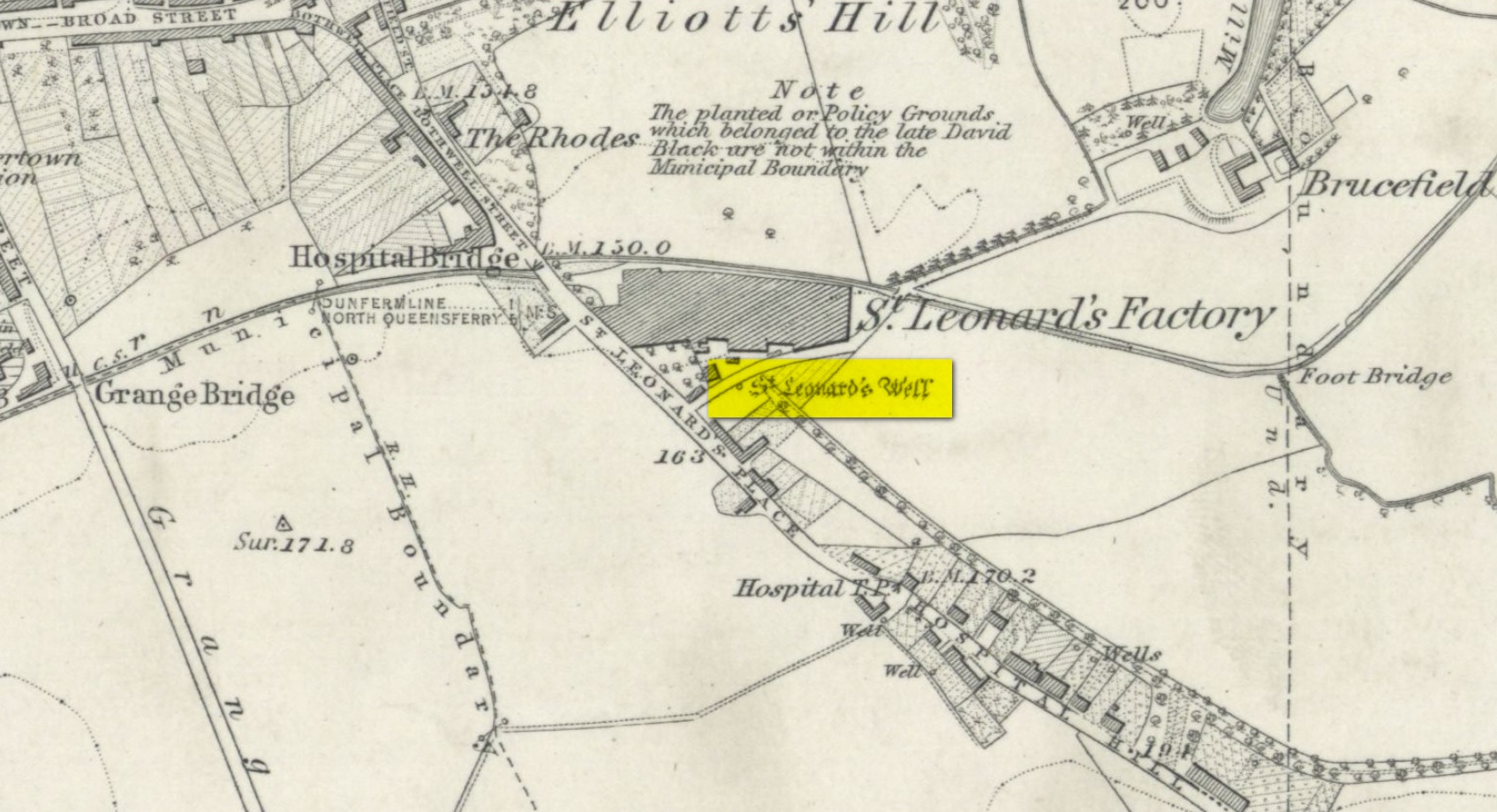
In Pete Chalmers (1844) historical brief about the long lost chapel and hospital of St. Leonard (and its associated holy well), mention is made of this long forgotten relic. Its memory was preserved in an old place-name, and was to be found less than half-a-mile southeast of St. Leonard’s sites on,
“the high part of the road, about a quarter of a mile to the south, the Spital-Crosshead, (named) from a pillar which, according to tradition, was erected there, decorated on the top by a St Andrew’s Cross, and removed probably towards the close of the 16th or 17th century.”
The cross is believed to have been erected in the 15th century.
Holy Well (destroyed): OS Grid Reference – NT 0976 8666
Archaeology & History
Site shown on 1856 map
There seems to be very little information available about this holy well, lost long ago and now hidden beneath the foundations of a food superstore! It was found in close association with both a chapel and a hospital in St. Leonard’s name—both of which have also been destroyed. The water from here may have been used by the monks for patients in the hospital, but that’s purely speculative. St. Leonard was known to be connected with lepers, which may be something that the waters here were used to treat. But again, I’m speculating…
When the Ordnance Survey lads came here in 1853, the waters were still running and they subsequently added it to their map a few years later. The site was still visible when Erskine Beveridge (1917) came here, telling us briefly that,
“St. Leonard’s Well still remains a little to the south-east, and, though now built up, is recognisable.”
But a few years later it had been destroyed and its position was shown on the updated OS-map of 1926 as “Site of.” The old well had gone…
Simpkins, John Ewart, Examples of Printed Folk-lore Concerning Fife, with some Notes on Clackmannan and Kinross-shires, Sidgwick & Jackson: London 1914.
Walker, J. Russel, “‘Holy Wells’ in Scotland,” in Proceedings of the Society of Antiquaries of Scotland, vol.17 (New Series, volume 5), 1883.
Acknowledgements: Big thanks for use of the 1st edition OS-map in this site profile, Reproduced with the kind permission of the National Library of Scotland.