Dave’s Stone, Rivock, Riddlesden, West Yorkshire

Cup-Marked Stone:  OS Grid Reference – SE 07634 44209
Getting Here

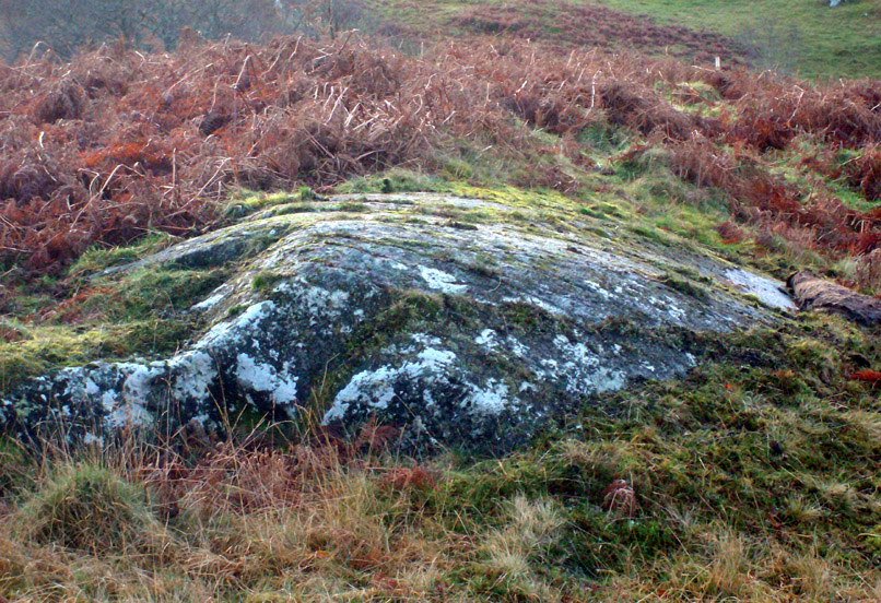
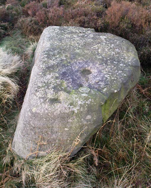
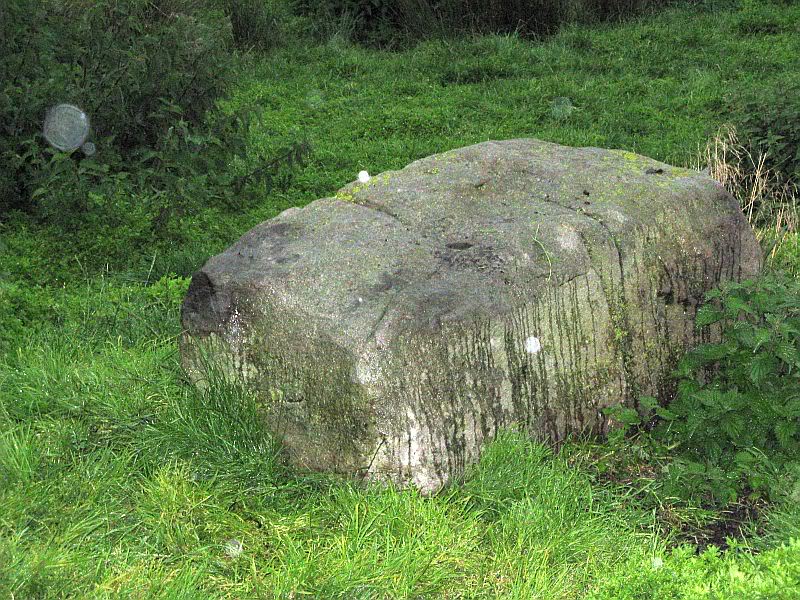
Rock with cup-markings

From the B6265 valley road between Bingley and Keighley, just near Riddlesden Hall, take the road up and over the canal into Riddlesden, bearing left up past West Riddlesden Hall and up Banks Lane. As you reach the T-junction at the top, where you hit the Silsden Road that goes round the moors, park up. Takes the footpath across the road and walk straight uphill, all the way to the top just above where the tree line ends and you’re on the moorland flat.  Bear right, over one wall, then walk 20-30 yards further and the stone in the photo here should be roughly under thine nostrils!

Archaeology & History

There’s no previous record of this as a cup-marked stone, so it needs adding here.  I’ve gotta admit that I’m not 100% sure about it as a real prehistoric carving — but considering the dubious nature of the nearby Carving no.58 and the Rivock Nose Stone, this is roughly somewhere in-between in terms of its legitimacy as an ancient carved stone.  Certainly I’ve come across other cup-markings, adjudged by newly-qualified ‘professionals’ as fine, but which I find highly questionable — so this one that Dave Hazell came across a couple of years ago should certainly be added to their professional rock art catalogues.

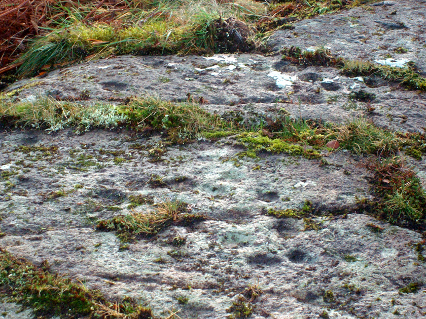
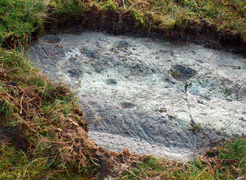
Close-up of the cupmarks

It’s simple enough: a four-feet long stone, whose top east-facing edge has been worked in more recent centuries by the miners who dug on the slopes below (perhaps to turn it into a gatepost?).  There are three notable ‘cups’ that are clearly visible on the photos here.  The topmost cup is something pretty recent, having had industrial attention given it; the largest cup may be natural; but the one in the middle seems to be what our English Heritage rock-art enthusiasts term a legitimate prehistoric petroglyph.  It certainly seems a good one!  Have a look for yourself and see what you reckon! It’s in a good spot and is certainly worth the wander, if only to have a look at other cup-and-rings in the region.

© Paul Bennett, The Northern Antiquarian

Rivock Edge (60), Silsden, West Yorkshire

Cup-and-Ring Stone:  OS Grid Reference – SE 07476 44475

Also Known as:

  1. Carving no.22 (Hedges)
  2. Roof Stone

Getting Here

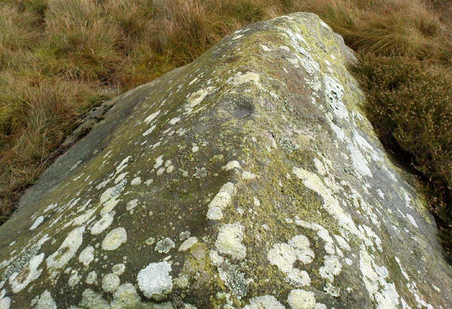
Cup-mark on top of the rock

From the B6265 valley road between Bingley and Keighley, just near Riddlesden Hall, take the road up and over the canal into Riddlesden, bearing left up past West Riddlesden Hall and up Banks Lane. As you reach the T-junction at the top, where you hit the Silsden Road that goes round the moors, park up. Cross the road and follow the footpath up the field, but walk up the side of the field-wall where the woods are, all the way to the top. On the flat, you’ll see a gap in the woods on your left, and the triangulation pillar atop of Rivock Edge 150 yards away.  Head towards it, watching out for one of the natural rocks rising near the middle of the grasses. It’s one of them!

Archaeology & History

Faint cup-and-ring, centre of photo

Exactly halfway between the cup-marked Niplet Stone and the large flat Carving 58 (Boughey & Vickerman survey) is this natural long upright rock, shaped in the form of a house-roof, with its apex running along an axis SE-NW, its sloping sides dropping either side into the deep wet heather.  Upon its crown is what may be a singular cup-marking, almost perfectly formed, though is just as likely to be Nature’s handiwork as much as anything else.  But on its western-face, within the mass of old lichen painting the rock surface, a more distinct man-made cup-mark has been cut.

On its eastern face, close to where the rock meets the boggy Earth, a singular faint cup-and-ring design can be made out, albeit a somewhat mis-shapen one.  It’s easily missed if the lighting isn’t too good as it’s very eroded indeed.  The carving was first described in Mr Hedges (1986) survey, where he told:

“Rough grit rock with ridge, in crowberry and heather with cup and ring on E edge and possible cups and grooves.”

The stone’s certainly worth visiting, as a number of other cup-and-ring stones scatter this region — half of them officially recorded, but nearly as many again that aren’t.  It’s a good area to explore.

References:

  1. Bennett, Paul, “The Prehistoric Rock Art and Megalithic Remains of Rivock & District (parts 1 & 2),” in Earth, 3-4, 1986.
  2. Boughey, Keith & Vickerman, E.A., Prehistoric Rock Art of the West Riding, WYAS 2003.
  3. Hedges, John (ed.), The Carved Rocks on Rombald’s Moor, WYMCC: Wakefield 1986.
  4. Morris, Ronald W.B., “The Prehistoric Rock Art of Great Britain: A Survey of All Sites Bearing Motifs more Complex than Simple Cup-marks,” in Proceedings of the Prehistoric Society, volume 55, 1989.

© Paul Bennett, The Northern Antiquarian 

Rivock Edge (58), Silsden, West Yorkshire

Cup-Marked Stone:  OS Grid Reference – SE 07466 44497

Also Known as:

  1. Carving no.21 (Hedges)

Getting Here

Take the same directions as if you’re visiting the Rivock Edge 060 Carving.  It’s 25 yards NNW – you can’t really miss it!

Archaeology & History

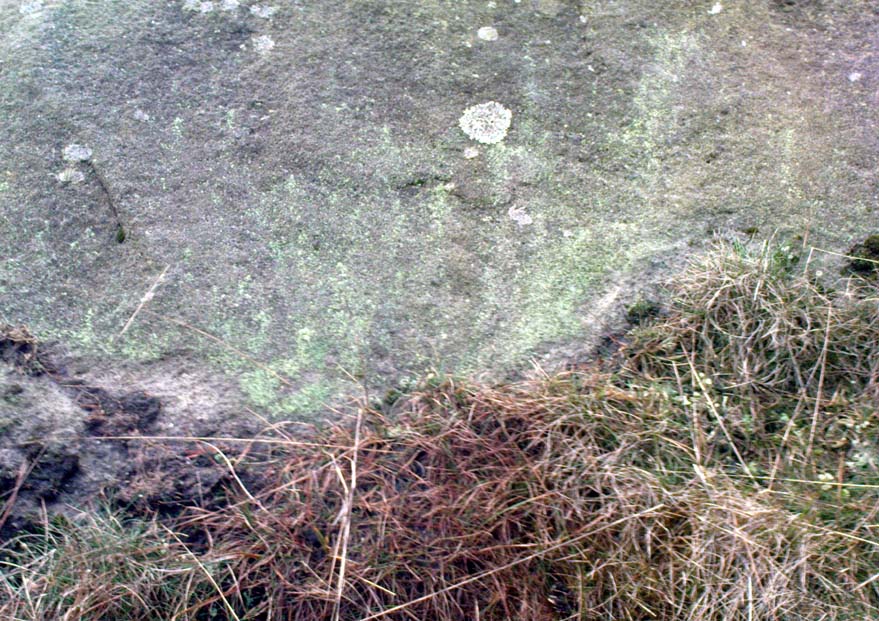
Rivock Edge, carving 58

This large flat rock, with a couple of long lines almost splitting the rock into sections, was first mentioned as a prehistoric site in John Hedges (1986) survey, where he described it simply as, “Large rough grit rock with possible four cups, in crowberry.” Boughey & Vickerman (2003) said even less about it!  One of the cups is very distinct, but the others are somewhat faded and perhaps even dubious.  It’s still worth a look at, if only due to the other better carvings nearby.

References:

  1. Bennett, Paul, “The Prehistoric Rock Art and Megalithic Remains of Rivock & District (parts 1 & 2),” in Earth, 3-4, 1986.
  2. Boughey, Keith & Vickerman, E.A., Prehistoric Rock Art of the West Riding, WYAS 2003.
  3. Hedges, John (ed.), The Carved Rocks on Rombald’s Moor, WYMCC: Wakefield 1986.

© Paul Bennett, The Northern Antiquarian 
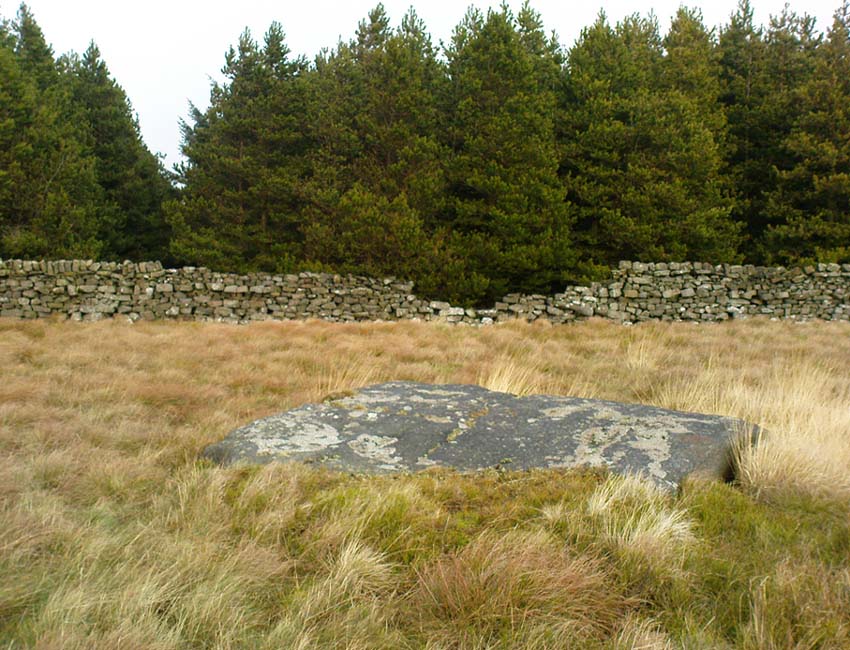

Snowden Carr Carving (569), Askwith Moor, North Yorkshire

Cup-and-Ring Stone:  OS Grid Reference – SE 17746 50923

Getting Here

Inma’s Drawing of the Carving

Takes a bitta finding unless you’ve got a GPS system, or someone like me to show you where it is! The best way’s probably via the Askwith Moor Road car park, up the road 160 yards till you hit the straight line cut into the moor on your right, where the landscape’s been damaged.*  Walk along this for less than 100 yards, then walk right, through the heather and onto the singular tree roughly 200 yards away.  From here, walk 75 yards (strides) north from the tree.  You’re damn close!

Archaeology & History

About 20 feet from a line of ancient walling in an area pretty rich in prehistoric sites, is this medium-sized stone with a lovely cup-and-ring design.  The carving was first recorded by fellow antiquarian, Eric Cowling (1937), in his short survey of other carved stones in the area.  He called this ‘carving no.7’ and described it, thus:

“In the central area of Snowden Carr is a barrow group, which occupies a slight ridge running from the edge of the bog to the east, almost to the moor road on the west.  The ridge is almost devoid of vegetation except at the higher end.  Here, on a heather-covered boulder, is marking no.7.  The cups are smaller than usual, and only one ring completely surrounds a cup.  The lines linking the cups are only lightly incised, and the whole marking has a delicate appearance.”

Old photo of the carving
Cowling’s 1937 drawing

I first visited this stone in the 1980s with fellow rock art student and author, Graeme Chappell, and for some reason it has always impressed me (I recall Graeme laughing whilst I made joyous noises and stroked the rock, reverentially!).  Cowling’s description of the stone as ‘delicate’ is appealing, as the stone and its design has a nurturing aspect to it, female in nature. (forgive me — but many of these stones tend to capture me in such ways!)  The stone was described more clinically in Boughey & Vickerman’s (2003) more recent survey as follows:

“Fairly large, flat, smooth grit rock with crack.  Up to seventeen possible cups, one with complete ring, one with partial ring, one with possible ring; connecting groove.”

Doesn’t quite capture the feel of the place, which I’m sure they’d admit.  The next time I’m up here, I’ll get some better photos of the carving.

References:

  1. Boughey, Keith & Vickerman, E.A., Prehistoric Rock Art of the West Riding, WYAS 2003.
  2. Cowling, E.T., ‘A Classification of West Yorkshire Cup and Ring Stones,’ in Yorkshire Archaeological Journal 1940.
  3. Cowling, E.T., Rombald’s Way: A Prehistory of Mid-Wharfedale, William Walker: Otley 1946.
  4. Cowling, E.T. & Hartley, C.A., ‘Cup and Ring Markings to the North of Otley,’ in Yorkshire Archaeological Journal 33, 1937.

ACKNOWLEDGEMENTS: Huge thanks to one of my fine ladies, Inmaculada Ibanez-Sanchez, for the drawing! Cheers Inma!

* A pipeline was laid across the moor here, and subsequent work (I presume by the same company) was done again in early 2011, cutting through and damaging several prehistoric monuments and destroying at least one prehistoric cairn.  An archaeological survey of the region should have been done before any work proceeded here, but I’m unaware of any such excavations, or archaeological reports preceding or concurrent to the ecological and historical damage performed.

© Paul Bennett, The Northern Antiquarian


Eastwoods Rough 3, Dacre, North Yorkshire

Cup-Marked Stone:  OS Grid Reference – SE 1850 6177

Getting Here

Cup-marked stone

Follow the same directions as if you’re going to the excellent Morphing Stone cup-and-ring carving.  From the carving, look up the field to the where the dirt-track is and, by the closest gate with a tree near it, walk straight towards it.  Roughly halfway between the Morphing Stone and the gate you’ll find — eventually — the small stone in the photo with well-defined cups on it.  You might need to wander back and forth until you find it, as there’s many rocks to check out here!

Archaeology & History

Possible cup-marked rock

This small cup-marked stone was rediscovered by Danny Tiernan in the late afternoon of Thursday, August 18, 2011, just as the heavens opened and the rains poured down!  With at least one well-defined cup-mark and another two near the edge of the stone where the grasses had grown, this stone probably needs another look at it, as there may be more beneath the surface, much like when we first found at Morphing Stone.

Danny also found and photographed another larger boulder, a bit further up the field closer to the fence, where what may be a single cup-mark is clearly seen living on top of the rock.  It’s one of those dodgy English Heritage ones though, so I’ll let those ‘qualified’ chaps check this one out and give it their expertise!  It could well be another unrecorded cup-marked stone though…

Links:

  1. Eastwoods Rough & other Nearby Sites

ACKNOWLEDGEMENTS: Thanks to ‘QDanT’ for him & Teddy’s photos, above.

© Paul Bennett, The Northern Antiquarian
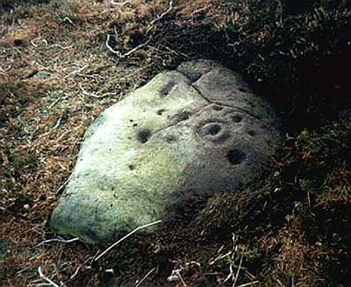

Lochmaloney, Kilmany, Fife

Cup-and-Ring Stone (destroyed):  OS Grid Reference – NO 379 204

Archaeology & History

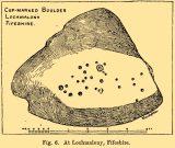
J.R. Allen’s 1882 sketch

Here’s another old carving that has succumbed to the lack of animistic respect endemic in modern culture.  Ronald Morris (1981) reported that this carved rounded boulder was “dynamited by the farmer and (is) now no longer extant.”  First described in 1882 and later included in the Fife Inventory (1935), the large smooth rock used to lay within a nice copse of dense gorse, measuring 2½m x 1¾m across and about 1m high from ground level.

It was uncovered in 1872 and mentioned briefly for the first time in Arthur Mitchell’s (1874) fine essay on the antiquities of Cromar, where he told that “Dr. Batty Tuke tells me there is a cup stone on a moor forming part of Lochmalonie farm, in the parish of Logie, Fifeshire.”  His notes were followed up by the great Romilly Allen (1882), whose sketch is all that remains of this ancient site.  The carving was subsequently included in one of Ron Morris’s (1981) survey of Scottish petroglyphs, describing it simply as,

“2 cups-and-one-complete ring (one mostly weathered off), diameters 10cm (4in) and 27 cups (carving depth and angle of slope not now known.”

Its isolation from any other known petroglyphs is a little odd and there is every possibility is accompanied a prehistoric burial of some sort; although from the attitude of the farmer, all trace of that would have gone too.  On a more positive note, when Batty Tuke spoke with Romilly Allen about this carving, he told that he has “frequently noticed well-marked cups on dry stone dykes in the Glenduckie area.”  Petroglyph explorers amongst you might want to spend some time meandering in this neck o’ the woods….

References:

  1. Allen, J. Romilly, “Notes on some Undescribed Stones with Cup Markings in Scotland,” in Proceedings of the Society of Antiquaries Scotland, volume 16, 1882.
  2. Mitchell, Arthur, “Vacation Notes in Cromar, Burghead and Strathspey,” in Proceedings of the Society of Antiquaries Scotland, volume 10, 1874.
  3. Morris, Ronald W.B., The Prehistoric Rock Art of Southern Scotland, BAR: Oxford 1981.
  4. Royal Commission on Ancient & Historical Monuments, Scotland, Eleventh Report with Inventory of Monuments and Constructions in the Counties of Fife, Kinross and Clackmannan, HMSO: Edinburgh 1935.

© Paul Bennett, The Northern Antiquarian
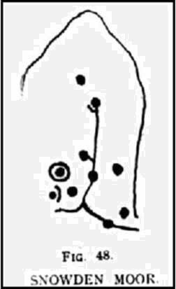

Queen’s Wood, Acharn, Kenmore, Perthshire

Cup-and-Ring Stone:  OS Grid Reference – NN 7640 4291

Also Known as:

  1. Canmore ID 25010

Getting Here

Ornate cup-and-ring in Queens Wood (after RCAHMS 2004)

From Kenmore, take the road towards Acharn on the south-side of Loch Tay for about a mile. Just as you go out of Acharn, watch for the small road of Queens Drive on your left going uphill. Go up here, following the tree-lined burn (stream) towards the superb Falls of Acharn, crossing the track over it and winding uphill still, until the track veers left across open fields towards the large woodland 400 yards east.  Just before the track meets the trees, notice the small burn running into the woods.  Follow this for some 200 yards – and where it bends more sharply to go uphill, keep going for another 75 yards upstream until you meet with another opening going east.  The rocky outcrop here is where this carved stone is found.  Look around!

Archaeology & History

Hidden deep within the woods where wet feet and good ankles come together, is this fine example of a cup-and-ring stone, perhaps having something in times of olde to do with the meeting of the waters.   A cluster of urisks and prehistoric remains scatter this lovely rolling section of southern Loch Tay, but I’ve found nothing specific to this bitta woodland that might give added mythos to the site.  The carving was described in Mr Stark’s (2005) fine little work on the local rock art, saying:

“A rock outcrop, situated in woodland between Acharn Burn and the burn running down to Remony House, bears at least thirty-six cupmarkings.  There are twenty-four plain cups, three cups each with a single ring, three cups each with double rings, and a cup surrounded by three faint rings, which has a gutter leading to the NW.  The cups range from 40mm to 75mm in diameter and from 60mm to 120mm in depth.”

The next time we visit the place, I’ll make sure I get some good photos – and visit the stone circle and settlement a few hundred yards further up the hill…

References:

  1. Stark, Gordon (ed.), Cupmarked Stones in Strathtay, Breadalbane Heritage Centre 2005.

© Paul Bennett, The Northern Antiquarian
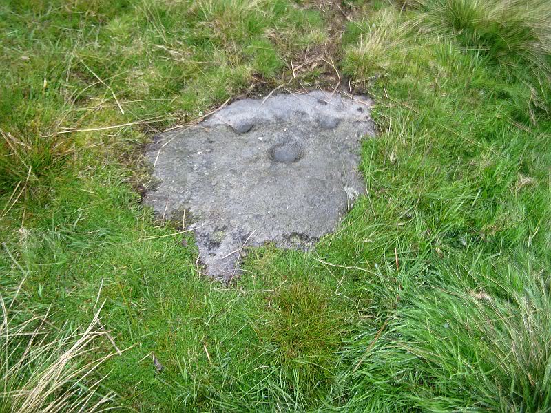

Corrycharmaig 1, Glen Lochay, Killin, Perthshire

Cup-Marked Stone:  OS Grid Reference – NN 52794 35503

Also Known as:

  1. Allt Coire Charmaig
  2. Canmore ID 24163

Getting Here

Corrycharmaig 1 stone

Go thru Killin and, just past the Bridge of Lochay hotel, take the tiny road on your left.  Go down here for 3 miles till you pass the gorgeous Stag Cottage (with its superb cup-and-rings in the field across the road) for another 300 yards, until you see Duncroisk Farmhouse set back on your right.  On the other side of the road, go thru the giant deer-gates (close ‘em behind you) to the river-bridge and across it.  Walk along the track till you reach the turning to Corrycharmaig House on the right (over the stream), but here, go up into the field thru the gate.  Walk up the hill ahead of you with its trees on the left, walking up onto the grassy level, over the deer-fence, then up again to the rounded knoll another 100 yards up.  You’re here!

Archaeology & History

On my first visit to this stone, in overcast and wet conditions — the easternmost of at least four separate carved rock faces along the same geological ridge — I only noticed a handful of cup-marks etched onto the northeastern section of the stone. But I was sure there were supposed to be more.  And when I returned home to check up, found that Ron Morris (1981) said there were “40 widely scattered cups of which, however, 29 well-defined cups are in a compact group, of which 6 are in a line.”  Much more than what I saw! And when I checked further, it was evident that even more cup-marks were once visible on the rock.  In the very first description of this carved stone, E.A. Cormack (1952) told:

“On the easterly area there are about 70 small cups, roughly one inch in diameter, in groups of ten to twelve. Most are on the flatter rock surface, but some are on the steeper slope facing south, which also bears the marks of deep glacial scorings.”

A sample of cups on ‘Corrycharmaig 1’

So on our visit here again a few weeks ago when we stayed at Corrycharmaig house*, a couple more visits allowed a slightly better investigation, albeit in even wetter and cloudier conditions than our first visit!  And the more we looked, the more we could see; and it was plainly evident that a number of cup-marks had become receptacles for moss-growth!  We counted at least 40 cup-markings on this ‘Corrycharmaig 1’ stone, but it seemed pretty obvious that beneath the grasses and vegetation, more carvings would be found.

Walking SSE along the same rocky ridge brings you to the other rock faces of Corrycharmaig 2, 3 and 4 — all with their own carvings.  Corrycharmaig 2 possessing the only known complete cup-and-ring on the ridge.  More carvings remain hidden nearby…

References:

  1. Cormack, E.A., “Cross-Markings and Cup-Markings at Duncroisk, Glen Lochay,” in Proceedings of the Society of Antiquaries, Scotland, volume 84, 1952.
  2. Morris, Ronald W.B., The Prehistoric Rock Art of Southern Scotland, BAR 86: Oxford 1981.
  3. Royal Commission on the Ancient & Historical Monuments of Scotland, Archaeological Sites and Monuments of Stirling District, Central Region, Society of Antiquaries of Scotland 1979.

* Huge thanks Sylvana!! – please let us know when we can stay again!

© Paul Bennett, The Northern Antiquarian

Duncroisk 6, Glen Lochay, Killin, Perthshire

Cup-Marked Stone:  OS Grid Reference – NN 53466 36485

Getting Here

Position of ‘Duncroisk 6’ cup-marked stone

Follow the same directions to reach the Duncroisk Crosses stone.  From here, look up the slope to your right and you’ll see the line of fencing running uphill.  Follow this until you reach the ruined remains of the old sheepfold building.  From here, look towards the tree-lined gorge of Duncroisk Burn, a few hundred yards west and walk towards it for about 50-60 yards.  There’s a group of three rocks hereby, two are large, but the carving’s on the smallest one in the middle.

Archaeology & History

This cup-marked stone was rediscovered as a result of the fine archaeological survey work by that Glasgow bunch of Certified Field Archaeologists, in their assessment of remains in and around Duncroisk Farm.  As well as mentioning — albeit briefly — the carvings of Duncroisk Farm and Duncroisk Crosses, Dugald MacInnes (2001) and his team came across another that hadn’t been recorded before.  Described in their survey as ‘feature 2’, he told,

“Some 20 metres downslope from the sheep fank and about 60 metres NW from it, there is a group of large boulders.  On the southeast sloping face of one of these there are three previously unrecorded cup-marks.  These are oriented vertically on a northeast to southwest alignment and are no more than 4cm apart.  They are all about 7cm in diameter and 2.5cm deep.”

The carved rock is a relatively small one sitting roughly in between two much larger rocks, both of which are easily visible from the Duncroisk Crosses stone less than 100 yards down the slope.  It’s probably only gonna be of interest to the rock-art purists among you and some may even question its veracity, particularly the bottom of the three cups, which gives the impression of being unfinished.  If you visit the site in summer and autumn it will be much harder to find, as it gets overgrown with bracken. (we did take a number of photos of this stone, but managed to somehow delete them all before saving to disk – so have gotta check it again when we next visit here)

References:

  1. MacInnes, Dugald, An Archaeological Field Survey of a Deserted Settlement at Duncroisk Farm, Glen Lochay, Association of Certified Field Archaeologists: Glasgow 2001.

© Paul Bennett, The Northern Antiquarian

Corrycharmaig 4, Glen Lochay, Killin, Perthshire

Cup-Marked Stone:  OS Grid Reference – NN 52768 35504

Getting Here

‘Corrycharmaig 4’ cup-marked stone

Follow the same directions to get to the Corrycharmaig 3 carving; and just a yard or two to the right of the far western edge of the rock, you’ll see another smaller slightly sloping rock, closer to the fencing, with faint cup-markings.  That’s the one! (note that the 10-figure grid reference given here might need adjusting slightly)

Archaeology & History

This small slightly sloping piece of exposed rock is on the western extremity of the Corrycharmaig cluster of carvings, but is a distinctly separate piece of rock from the Corrycharmaig 3 stone (though part of the same outcrop).  The stone itself has two sections to it, with a natural crack in the rock defining eastern and western section — both of which possess cup-marks.

The easternmost section of the stone has seven cup-marks, some of which were only recently uncovered.  A large single cup-mark sits near the middle of this portion of the rock; this is probably what Mr Cormack (1952) was talking about when he told that, “further west (of the Corrycharmaig 3 carving, PB) is one isolated larger cup of 4-inch diameter.”  On the western side of the stone, we find just two or three cup-marks, though one large cup-marking here would seem to be Nature’s handiwork.

It is highly likely that beneath the excessive vegetational growth around this carving and others along this ridge, other sections of prehistoric carvings remain to be found.

References:

  1. Cormack, E.A., “Cross-Markings and Cup-Markings at Duncroisk, Glen Lochay,” in Proceedings of the Society of Antiquaries, Scotland, volume 84, 1952.
  2. Morris, Ronald W.B., The Prehistoric Rock Art of Southern Scotland, BAR 86: Oxford 1981.
  3. Royal Commission on the Ancient & Historical Monuments of Scotland, Archaeological Sites and Monuments of Stirling District, Central Region, Society of Antiquaries of Scotland 1979.

© Paul Bennnett, The Northern Antiquarian