Flat Howe (1), Sleights Moor, Sleights, North Yorkshire

Tumulus:  OS Grid Reference – NZ 85483 04866

Also Known as:

  1. Flat Howe (north)

Getting Here

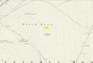
Flat Howe-1 on 1853 map

Along the A169 road that runs may miles from Whitby to Pickering, as you go through the small town of Sleights, the road gets steep for a mile or so, until you reach the moorland tops, where the road runs dead straight.  After 1.2 miles (1.93km) along the straight road, a small minor road is to your right.  Go along here for literally half-a-mile (0.8km) where you’ll see a small dirt-track on your right, with a locked gate.  There’s place to park here.  You’ll see the large rounded mound of Flat Howe-2 about 200 yards NE.  Head there, then another 250 yards north.  You’ve arrived!

Archaeology & History

Of the two ‘Flat Howe’ burial mounds on Sleights Moor, this is the northern one of the two, being 250 yards (230m) away from its southern companion (at NZ 85510 04614).  It’s quite a big fella too – and so you’d expect there to be quite a bit of information about it.  But there isn’t!  No recorded excavation has taken place here, despite the top of the monument being cut into.  But this might have occurred when the Ordnance Survey lads built one of their triangulation pillars into the side of it.  Thankfully it’s not done too much damage.

I was quite surprised to find that even Frank Elgee (1912; 1930) had little to say about either of the two Flat Howes, simply mentioning them in passing in relation to the numerous other prehistoric tombs on these moors.  Despite this, the archaeologist L.V. Grinsell (1936) thought this site to be one of “the finest peristalith barrows I have ever seen.”  And this one in particular is still very impressive.
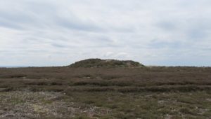
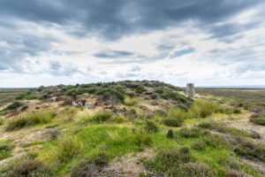
Flat Howe from the south
Flat Howe (by James Elkington)

First shown on the 1853 OS-map, this large heather-covered mound of earth and stone is some six feet high and measures roughly 22 yards (20m) east-west by 19 yards (17.5m) north-south.  The tomb was originally constructed within a circle of reasonably large boulders, some of which were upright.  These can still be seen, mainly along the western and southern sides of the monument, although many have been dislodged over time and fallen at various angles, as you can see in the photo.  Whether or not these stones were erected first and then the mound built inside the ring, we do not know.  It’s the highest point in the landscape on Sleights Moor, with damn good views in all directions: an element that is common to many large prehistoric tombs, for obvious reasons.  Other tombs of similar size and probably similar periods in prehistory can be seen close by and on the skyline.  Whether this was a deliberate visual ingredient by our tribal ancestors is difficult to say, as the moors here were covered in scattered woodlands in prehistoric times.  Only detailed archaeo-botanical surveys would be able to tell us one way or the other.

Folklore
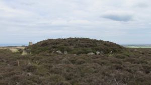
Flat Howe, with large stones defining its edge

Although we have nothing specific relating to this tomb, an olde creation myth told us that the local giants, Wade and his wife Bel, left their young son (whose name seems to have been forgotten) somewhere on Sleights Moor (which aint a big place).  It is worth narrating simply because it may have related to this tomb or its companion close by.  Giant legends have long been associated with the creation of many prehistoric tombs in this country and abroad.  The story was first written down by George Young (1817) in his magnum opus on Whitby and the tale was subsequently re-told by many others – Mrs Gutch (1901) for one:

“Young Wade, even when an infant, could throw a rock several tons weight to a vast distance; for one day when his mother was milking her cow near Swarthoue, the child, whom she had left on Sleights moor, became impatient for the breast, and seizing a stone of vast size, heaved it across the valley in wrath, and hit his mother with such violence, that though she was not materially hurt, her body made an impression on the stone which remained indelible, till the stone itself was broken up, a few years ago, to mend the highways!”

This rock was Bel’s Rock, whose exact location seems to have been lost.

References:

  1. Elgee, Frank, Early Man in Northeast Yorkshire, Frank Bellows: Gloucester 1930.
  2. Elgee, Frank, The Moorlands of North-Eastern Yorkshire, A. Brown: London 1912.
  3. Grinsell, Leslie V., The Ancient Burial Mounds of England, Methuen: London 1936.
  4. Gutch, Mrs, County Folk Lore – volume 2: Examples of Printed Folk-lore Concerning the North Riding of Yorkshire, York and the Ainsty, David Nutt: London 1901.
  5. Jeffrey, P. Shaw, Whitby Lore and Legend, Home: Whitby 1923.
  6. Roberts, Anthony, Sowers of Thunder, Rider: London 1978.
  7. Smith, A.H., The Place-Names of the North Riding of Yorkshire, Cambridge University Press 1928.
  8. Young, George, A History of Whitby and Streoneshalh Abbey – volume 2, Clarke & Medd: Whitby 1817.

AcknowledgementsA huge thanks to Lindsay Mitchell for getting us up to see this great tomb and its companion; and to James Elkington for use of the photograph.

LinksThe Megalithic Portal on Flat Howe

© Paul BennettThe Northern Antiquarian


Southdown Cottage, Cotmandene, Dorking, Surrey

Tumulus (destroyed):  OS Grid Reference – TQ 1686 4958

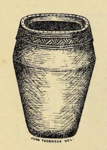
The Cotmandene urn

Archaeology & History

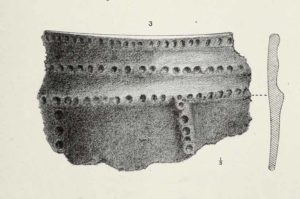
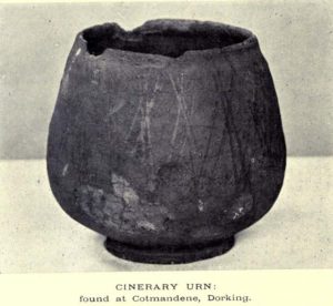
Highlighted on the 1914 OS-map (as ‘Site of’), nothing now remains of the prehistoric structure that either covered or surrounded the ancient burial urn, found fortuitously by a Mr Turner in the garden of Southdown Cottage at the beginning of the 20th century.  Believed to be either Iron Age or Romano-British in origin, the find was noted by Mr Malden (1913) in his brief in the Surrey ArchaeologicalCollections, who wrote:   

“Early in 1913 it came to my knowledge that some years ago some discoveries had been made in the garden of a house on Cotmandene, Dorking.  Mr Turner…was digging for sand in his garden when he found a small cinerary urn (see illustration), with ashes in it.  The height is only 5 inches, the diameter across the top about 4 inches, but at the widest part 5⅜.  The urn is so small that it probably contained the ashes of a child: it is wheel-made, but badly; the diameter is not precisely the same across the top from every direction: Mr Reginald Smith attributes it to the first century BC.  Some fragments of other urns were found.  Mr Turner has kindly presented the whole specimen to the Society’s Museum.  At a lower depth in the same garden were numerous flints, some implements, many flakes, and traces of a hearth with several burnt stones. These clearly belonged to an earlier date, considerably, than the interments, but as the finds were made about 1906-7, and not investigated till this year, it is impossible to be precise about the depth at which they occurred.”

References:

  1. Malden, H.E., “A Cinerary Urn and other Matters found at Dorking and Betchforth,” in Surrey Archaeological Collections, volume 26, 1913.

© Paul BennettThe Northern Antiquarian


Rolleston’s Barrow, Rushmore, Tollard Royal, Wiltshire

Tumulus:  OS Grid Reference – ST 95552 18233

Archaeology & History

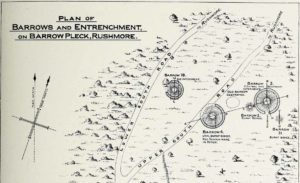
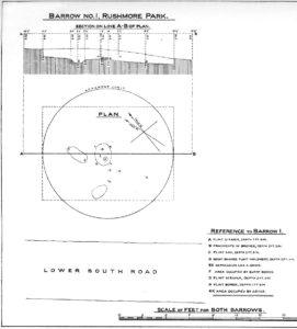
Plan of Rollestons Barrow, 1880

In what today seems a barely visible tumulus, amidst the large cluster that could once be found upon the large estate grounds of Rushmore House, were once the overgrown ruins of an old tumulus.  It seems to have been rediscovered in the 19th century, when the legendary antiquarian, General Pitt-Rivers, moved onto the huge estate.  It was all but hidden even in his day, he told, but being “of such slight elevation that, like many others, it had never been noticed.”  It was the first of all the barrows they excavated on his Estate, and is to be found “near the house on the south side of the lower south coach road.”

So, in 1880, he got some of the estate lads to help him and Rolleston start a dig into the old tomb – and they weren’t to be disappointed.  It wasn’t anything special, but it was the first amongst many hereby.  In Pitt-River’s (1888) massive tome on the prehistory of the region, he told us:

“This was the first barrow opened at Rushmore, on the 10th August, 1880. Professor Rolleston and the Rev. H. Winwood were present at the opening. The elevation was so slight that it had hitherto escaped notice.  In the centre, 1 foot 6 inches beneath the crest, a layer of charcoal and ashes, 9 feet by 6 feet, was found containing a burnt body.  The body appears to have been burnt on the spot, and not gathered up after cremation, but a mound raised over the funereal pile.  A few fragments of bronze, probably the remains of some implement which had corroded or been burnt, were found in the ashes, and in the body of the barrow two flint scrapers, a well-formed flint borer, and a boat-shaped flint…were found (see illustration above, PB).  A few scattered fragments of pottery found in the barrow were of a superior and harder baked quality than is usual in barrows.  No trace of a ditch was found around the barrow, but towards the north of the centre, a depression—EE on plan—which might, or might not, have been a grave, but filled with mould and without remains, was discovered.  The barrow is undoubtedly of the Bronze Age, and is interesting on account of it being the last at the opening of which Professor Rolleston assisted shortly before his death.”

As a result of this, he decided to name to barrow after his old friend and also planted a beech tree on top of it in remembrance of him.

References:

  1. Pitt-Rivers, A.H.L.F., Excavations in Cranborne Chase, near Rushmore – volume 2, Harrison & Sons: London 1888.

© Paul BennettThe Northern Antiquarian


Old Pleck Barrow, Rushmore, Tollard Royal, Wiltshire

Tumulus (destroyed):  OS Grid Reference — ST 95459 17548

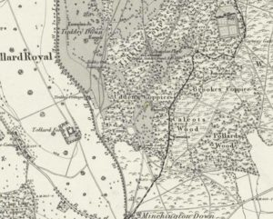
Old Pleck on 1889 OS-map

Archaeology & History

This long-lost burial mound was one in a large group of prehistoric tombs that were explored in the 19th century by the legendary antiquarian, General Pitt-Rivers. It had already been destroyed before the General came to live on his Rushmore estate in southern Wiltshire, but thankfully, his diligence as an inquirer prevailed and he was able to recover at least something of the old site.  Shown on the 1889 OS-map of the area (despite already having been destroyed), in Pitt-River’s (1888) extensive writings he told how, in the scattered woodlands hereby, was

Pitt-Rivers 1888 site-map
Old Pleck Barrow urn

a collection of large barrows near the South Lodge.  They were covered with a thick grove of hazel and other underwood.  One of the barrows—marked by a dotted circle (see sketch-map, left, PB)—had been destroyed before my arrival at Rushmore in 1880.  The earth of the barrow had been removed and a good urn found in it, which had been broken and scattered, but I was fortunate enough to recover one of the fragments which had been preserved by the estate carpenter.

From a sketch that was made of the urn remnant, Pitt-Rivers told how “the character of its ornamentation” resembled that on another urn found in one of the nearby tumuli.

References:

  1. Pitt-Rivers, A.H.L.F., Excavations in Cranborne Chase, near Rushmore – volume 2, Harrison & Sons: London 1888.

© Paul BennettThe Northern Antiquarian 


Lower Lanshaw Dam (02), Burley Moor, West Yorkshire

Cup-Marked Stone:  OS Grid Reference – SE 14223 44888

Getting Here

Along the moorland road between Cow & Calf and The Hermit pub, park up at the small wooded bit by the right-angle bend and cross over the Coldstone Beck.  Walk up onto the moor itself and stick to the path that runs roughly parallel with the slowly-drying stream, towards Lower Lanshaw Dam.  About 100 yards before it, walk left, into the heather, for about 50 yards.  You’re damn close!

Archaeology & History

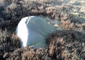
Lower Lanshaw Dam carving
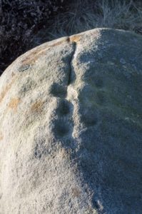
Close-up of cupmarks (by James Elkington)

This is another neolithic or Bronze Age carving I first came across during one of my weekly rambles across these hills as a child, and upon revisiting the place a few days ago with James Elkington, found it associated with nearby cairns and what looks to be the remains of prehistoric walling – none of which I noticed when I was a kid.  The petroglyph is a simple design, primarily consisting of two rows of three cup-marks: one row of three along the top or spine of the rock, and another one immediately beneath it, an inch or so below.  The topmost line of cups runs into a natural crack in the rock, which runs down the northwest edge of the stone.  A possible faint cup and partial ring emerges on the southeast side of the topmost row of cups, but this is difficult to make out.  On the sloping northwest face of the rock is another single cup-marking.

References:

  1. Bennett, Paul, Of Cups and Rings and Things, unpublished: Shipley 1981.

Acknowledgements:  Many thanks to James Elkington for use of his photo to illustrate this petroglyph

© Paul Bennett, The Northern Antiquarian

Lower Lanshaw Dam (01), Burley Moor, West Yorkshire

Cup-Marked Stone:  OS Grid Reference – SE 1416 4489

Getting Here

Take the same directions as if you’re visiting the Lanshaw Dam 2 petroglyph, then keep walking directly towards the Lanshaw Dam, 130 yards east.  Halfway between the two, closer to the footpath, look out for a stone of similar shape and dimensions to Lanshaw 2, just by a prehistoric cairn.  You’ll find it!

Archaeology & History

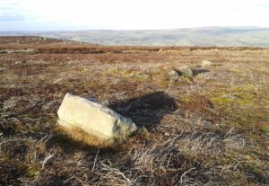
Cup-marked stone & cairn
Close-up of cup marking

As with a great number of petroglyphs in and around Yorkshire, this large single cup-marked rock is found in close association with a reasonably large prehistoric cairn (several others are close by), some 3 yards in diameter.  The cup-marking here is larger than yer average cup-mark on these moors, being four inches across. It can clearly be seen on the southern vertical face of the rock and doesn’t appear to have been recorded before.  On the whole, it’s nothing special to look at and is probably just one for the petroglyphic purists amongst you.

© Paul Bennett, The Northern Antiquarian
Moonzie, Cupar, Fife

Cup-Marked Stone:  OS Grid Reference – NO 34 18

Archaeology & History

There are no previous literary references to this small portable cup-marked rock, relocated recently by Paul Hornby during one of his various antiquarian meanderings.  Found in association with a much later architectural structure, it position in the landscape (near the top of a hill) would suggest that is was most probably located in a prehistoric cairn in earlier days—all traces of which have vanished.  But we cannot be sure of this and I’m merely speculating.

Moonzie cup-marked stone

Site of carving

The thin, fairly flat stone is about 18 inches across, by a foot wide, and consists of what seems to be 10 cup-marks (no rings, sadly), of which six of them are the real deal.  No other carvings officially exist anywhere near it and its isolation is an enigma… such as it is with petroglyphs…

Due to the fact that the stone can literally be picked up and moved by anyone, we’re hoping that it can be seen by local archaeologists and perhaps placed into a museum for safe-keeping.

© Paul BennettThe Northern Antiquarian 


Kalemouth Carving, Eckford, Roxburghshire

Cup-and-Ring Stone:  OS Grid Reference – NT 714 275

Archaeology & History

Kalemouth carving (after R.W.B. Morris 1981)

Now housed in the National Museum of Antiquities in Edinburgh, this little-known petroglyph was rediscovered in 1957 by a Mr G.F. Ritchie, not far from the once-large Kalemouth neolithic tomb.  It’s a carving that seems to be quite isolated (no others are known about in the immediate area), comprising of an incomplete four-ringed design which, in all probability, is a stray rock that came out of a nearby prehistoric cairn—although we don’t know this for sure.

The carving was described in Ron Morris’ (1981) petroglyph survey, where he told us that,

“In the field “not far from the cairn” (just E of the farm), was a small convex gritstone boulder 25cm by 15cm by 15cm (¾ft  x ½ft x ½ft). On its fairly smooth surface is:

a cup-and-four-rings with 2 parallel grooves from the inner ring (which is incomplete) through the others (which are gapped)—the outer two being now incomplete also—a form of ‘keyhole pattern’.”

A near-identical carving on a similiar-shaped portable stone can be seen in Galashiels museum, whose history has seemingly been forgotten.

References:

  1. Morris, Ronald W.B., “The cup-and-ring marks and similar sculptures of Scotland: a survey of the southern Counties – part 2,” in Proceedings of the Society of Antiquaries, Scotland, volume 100, 1967.
  2. Morris, Ronald W.B., “The Cup-and-Ring and Similar Early Sculptures of Scotland; Part 2 – The Rest of Scotland except Kintyre,” in Transactions of the Ancient Monuments Society, volume 16, 1969.
  3. Morris, Ronald W.B., The Prehistoric Rock Art of Southern Scotland, BAR: Oxford 1981.

© Paul BennettThe Northern Antiquarian


Lower Headley Farm, Thornton, Bradford, West Yorkshire

Tumulus (destroyed):  OS Grid Reference – SE 099 321

Archaeology & History

Headley Farm urn

There are no longer any remains of the prehistoric burial site that once stood in one of the fields by Lower Headley Farm.  We don’t know whether the site was a cairn, a tumulus, or just a stone-lined cist; but in all probability it would have been a low rounded hillock whose existence had long since fallen out of oral tradition.  All that we do know is that in one of the fields by the farm, some very well preserved urns—either neolithic or Bronze Age by the look of it—were unearthed, indicating a site of prehistoric provenance.

The finds were described only briefly in the first edition of the Bradford Antiquary (1888) journal, where it was reported:

“During the spring of 1880 an interesting discovery was made by Mr. Abraham Craven, quarryman, of Thornton.  The ‘find’ comprised three funeral urns, which Mr. Craven turned up while baring a portion of a field in Lower Headley Farm, the property of the trustees of Sowerby Grammar School.  The discovery was made within a short distance of the surface, the pottery presenting undoubted indications of pre-Roman origin.  From evidence collected upon the spot, and the appearance of the pottery, two of the urns were about 14in in height, 9in across the top, 11½in at the widest portion of the bowl, and 6in at the foot.  One of the urns was of sun-burnt clay, with rude markings, the other having evidently been subjected to fire.  No coins, personal ornaments, or other indications of civilisation, were found in the urns, but each one contained human dust and bones.  From the fact that several other urns have been met with in the immediate vicinity, equally rude in type, evidence is not wanting that the picturesque mound upon which Headley is situate was inhabited at a very early period of British history.”

References:

  1. Anonymous, “Valuable ‘Find’ at Headley, near Thornton,” in Bradford Antiquary, volume 1, 1888.

© Paul BennettThe Northern Antiquarian


Bedford Hill, Tooting, Surrey

Tumulus (destroyed):  OS Grid Reference – TQ 288 726

Archaeology & History

This long lost prehistoric tomb is one of many that has fallen under the destructive hammer of the christian Industrialists in this part of the country.  Located somewhere in the parkland grounds of Bedfordhill House (also destroyed), its memory was thankfully preserved by the renowned folklorist and historian Walter Johnson (1903) who wrote of it in his work on prehistoric Surrey, where he told:

“A few years ago a supposed barrow was levelled in Bedford Park, Bedford Hill, Tooting, and no record taken of the results. The mound was enclosed in the Park for several  centuries, but when the grounds were laid out for building purposes ten or a dozen years since, it suffered rough usage, and was finally destroyed. It was nearly 100 yards long, and about 20 feet in breadth in its highest part.  It ran East and West, and had several trees growing on it before its desecration….  A moat had been made round the mound for about two-thirds of its circuit.  This moat was supplied with water by the Ritherdon, a small stream rising in Streatham.  The name is preserved in the adjacent Ritherdon Road.  The material of the mound was gravel and gravelly loam, which, in the neighbourhood, occurred only in a thin layer, thus forbidding the conclusion that the structure was merely composed of the soil dug out in making the moat. The excavated material would largely be London Clay.  As the genuineness of this barrow was, we believe, called in question after its demolition, when the subject was beyond reconsideration, we mention two shreds of collateral evidence. The ground on which the tumulus stood was about the highest in the district. The name Tooting may also have some bearing, for Mr. Clinch thinks that it was a Celtic settlement where was worshipped the deity known as Taith. (Compare also toot-hill, as exemplified in Tot Hill, Headley, Tothill Fields, Westminster, famous for fairs and tournaments, also Tutt Hill, near Thetford.)”

The ‘toot’ in Toothill however, is ascribed by Gover, Mawer & Stenton (1934) as being the usual “look-out hill”.  Although they do make note of the fact “that there is no hill in Tooting which would make a good look-out place.”  But if this was a large barrow of some type, it would explain the etymological oddity.  Any further information on this site would be welcome.

References:

  1. Gover, J.E.B., Mawer, A. & Stenton, F.M., The Place-Names of Surrey, Cambridge Univserity Press 1934.
  2. Johnson, Walter, Neolithic Man in North-East Surrey, Elliot Stock: London 1903.
  3. Smith, A.H., English Place-Name Elements – volume 2, Cambridge University Press 1954.

© Paul BennettThe Northern Antiquarian