Crowned by a clump of trees (planted in 1740), this hilltop site is one of the more impressive of a number of tombs hereby, with its nearest other neighbour being 70 yards southeast of here. One of Dorset’s early tribal meeting places (Anderson 1934), the tomb was illustrated on Isaac Taylor’s 1765 map of the region and was dug into in 1858 “on the orders of a local magnate” (Marsden 1999), damaging some substantial portion of the tomb. Of this, craniologist and antiquarian John Thurnam was most displeased; for in his description of the opening of Culliford Tree he wrote:
“A wide trench had been dug through it one side, from the summit and the rubble which had been thrown out had not been replaced… Another subject of regret was the fact that though, as we were told by the neighbouring rustics, human remains, with pottery and certain other relics, were found in the barrow, no authentic account of the exploration had, so far as we could learn, been put to print.”
Leslie Grinsell (1959) found the same trouble in his assessment of this site; and the Royal Commission (1970) lads could only describe the site thus:
“Large trench on south and top almost certainly dug in 1858 when four secondary extended inhumations, one with necklace of amber and two gold-plated beads, and cremation with incense cup in collared urn, were found.”
However, it seems that the necklace and gold-plated beads have been “lost” — i.e., someone has them in their own private collection somewhere!
Folklore
This is one of very few tombs in this part of the country where we find the tradition of fairy music. Grinsell (1959) told that:
“The Culliford Tree barrow, formerly the meeting place of the Hundred of Culllingford Tree, is also known as the Music Barrow from the belief that music could be heard beneath the mound by those who listened at the apex at midday.”
References:
Anderson, O.S., The English Hundred-Names, Lunds Universitets Arsskrift 1934.
Marsden, Barry M., The Early Barrow Diggers, Tempus: Stroud 1999.
Royal Commission on Historical Monuments, An Inventory of Historical Monuments in the County of Dorset – Volume 2: South-East, Part 3, HMSO: London 1970.
Warne, Charles, Celtic Tumuli of Dorset: An Account of Personal and other Researches in the Sepulchral Mounds of the Durotriges, Smith: London 1866.
This once impressive tumulus a half-mile east of the village was first mentioned in the Bardney Cartulary in the early 13th century, where is was written as Spelhou. Suggested by Olof Anderson (1934) to have been an early moot site — “the meeting place of the Torbar Hundred” — this appears to be confirmed in Smith’s (1937) etymological analysis where he ascribes Spell Howe to be literally, “‘Speech mound’, from OE spell, speech and haugr” (burial mound). Rising about four-feet above ground level, this is a traditional ’round barrow’ type of tumulus. In recent years, reports tell that it has been built onto with some fencing. Hopefully the present land-owners now look after the place!
References:
Anderson, O.S., The English Hundred-Names, Lunds Universitets Arsskrift 1934.
Mortimer, J.R., Forty Years Researches in British and Saxon Burial Mounds of East Yorkshire, Brown & Sons: Hull 1905.
Smith, A.H., The Place-Names of the East Riding of Yorkshire and York, Cambridge University Press 1937.
The remains of this old tomb were first noted by Mr Alexander Gibson, whose photograph of the site is here reproduced. Thought by Paul Ashbee (1974) to date from between the Iron Age and Romano-British period, the site was first described in O.G.S. Crawford’s (1928) essay in Antiquity journal. It was just one of several such sites in relative proximity to each other and which, due to them being so close to the sea, have been all-but washed over by Nature’s advance. Mr Crawford told that this,
“cist on the shore…is on St. Martin’s, between Crethus Hill and English Island Point, about 20 yards from the edge of the rushy bank, and at approximately high water-mark. It is oriented north and south and is 3 feet long by 2 (feet) wide. It has now no capstone. The cist when found was full of coarse, gravelly sand and stones, which were cleared out; amongst this were parts of leg bones (the joint-ends missing) and smaller fragments; then a piece of a human jaw, without teeth, and finally the skull. The facial portion was missing. The skull fell to pieces on removal but it and all the other pieces were preserved and the cist filled in again.”
In the same article, Crawford notes that,
“nearby, to the west, were two or three other cists of the same type, and many years ago yet others were observed, both round this bay and at Lawrence’s, to the west of Crethus Hill.”
References:
Ashbee, Paul, Ancient Scilly, David & Charles: Newton Abbot 1974.
Crawford, O.G.S., “Stone Cists,” in Antiquity Journal, volume 2, no.8, December 1928.
In Crawford’s (1928) article on stone-lined burials, or cists, this was one site that he described from the Scilly Isles, though little can be seen of the site nowadays as a road was built on top of it. It was first discovered by a Mr Alexander Gibson (who took the photo, here reproduced) and was described as “the cist in the road”, due to its position in the middle of the old lane. A number of flints and other Crawford told that it,
“is in Town Lane, about midway between Holy Vale and the Marconi Station, St. Mary’s (lat. 49° 55′ 35.2″ N, long. 6° 17′ 52.5″ W). Nothing is known about it, but presumably it was found when the road was made by Mr Augustus Smith more than 80 years ago. It measures about 3 feet in length by 2 feet in width, and is oriented approximately NE-SW. There is said to have been another near it, but Mr Gibson has searched without success.”
In Paul Ashbee’s (1974) fine archaeological survey, he describes there being several other small prehistoric burials found in fields a little further down the same lane.
References:
Ashbee, Paul, Ancient Scilly, David & Charles: Newton Abbot 1974.
Crawford, O.G.S., “Stone Cists,” in Antiquity Journal, volume 2, no.8, December 1928.
Cairnfield (destroyed): OS Grid Reference – TQ 702 590
Archaeology & History
Ground-plan
In recent years it seems that very little has been written about this seemingly lost site, long since destroyed by the self-righteous advance of the Industrialists. It seems to have been an important place, as there were many cremated remains here in more than a dozen individual burial urns, some with flints deposited in them. The site was first described in a meeting of members of the Society of Antiquaries in 1898 by a Mr Frederick James. He talked about the site and some brief digging work around the area, thus:
“The site of the urnfield is on land belonging to Mr William Wigan, of Clare House, East Malling, and it was owing to his kind permission and active cooperation that I was enabled to visit the spot, which is on a small plateau above the River Medway, 350 yards to the southwest of New Hythe church, and between the river and the road leading from Rochester to Town Malling…
“The immediate neighbourhood…has been from time to time highly productive of archaeological remains dating from the Palaeolithic times and extended down to the Roman occupation… (But at) the Larkfield urnfield, the first indication that was afforded of the uses to which the area had been put in Romano-British times was the accidental discovery, whilst planting fruit trees, of some fragments of pottery (including portion of a Samian patera) found at the point marked A on the plan. A flat tile was found covering the fragments.”
Much more was found hereby, with the majority of the finds being “a group of urns containing cremated interments found in the urn-pits.” Although James (1898) described them as dating from the Romano-British period, from his description and illustrations it would seem that the remains here were probably of an earlier date, perhaps Iron- or even Bronze Age. But we may never know for sure.
Reference:
James, Frederick, “Discovery of a Romano-British Urnfield at Larkfield, near Maidstone,” in Proceedings of the Society of Antiquaries, 17:1, 1898.
Not too difficult to locate if you don’t mind wandering to and fro in deep heather. From the Askwith Moor Road parking spot, walk up the road (north) 300 yards until you see the disused quarry on the moor to your right. From here, head onto the moor, straight down past the quarry for about 200 yards, angling slightly to your right. You’ll notice some overgrown ‘lumps’ in the heather — deemed as a cairnfield by archaeologists — go just below these and watch out for some rocks emerging from the heather. This carving (and its neighbours) is on one of ’em!
Archaeology & History
This curiously-shaped large rock has several worn cup-and-rings on its upper surface, with several cup-marks aswell. Two deeply etched lines running down the edge of the rock have also been pecked away as part of the carving, in contrast to the distinguishing natural water-worn line that runs diagonally along and down to the bottom of the stone.
The site was first described by Eric Cowling (1937), who labelled it as Carving no.9 in his survey, saying:
Carving 582, looking SWCarving from above
“At the eastern and lower end of the barrow group on Snowden Carr is a cluster of angular boulders, one of which has several markings cut on the upper surface. There is a cup and ring on the highest, and alongside two rings are joined together and enclose separate cups. One corner of the area is isolated by a groove running from edge to edge, and within this enclosure are three cups.”
Catalogued as ‘stone 582’ in Boughey & Vickerman’s (2003) survey, their description of the carving was one with “fourteen possible cups, several with indications of a ring, some of which intersect; grooves.”
References:
Boughey, Keith & Vickerman, E.A., Prehistoric Rock Art of the West Riding, WYAS 2003.
Cowling, Eric T., “Cup and Ring Markings to the North of Otley,” in Yorkshire Archaeological Journal, part 131, 33:3, 1937.
Cowling, Eric T., Rombald’s Way: A Prehistory of Mid-Wharfedale, William Walker: Otley 1946.
From the Askwith Moor Road parking spot and walk up the road for about 500 yards an head to your right (east) onto he moor, above the rocky ridge known as Snowden Crags. After 100 yards or so of walking through the heather, the entire cairnfield is under your very feet! If the heather’s grown, you probably won’t see a thing.
Archaeology & History
First described in Eric Cowling Rombald’s Way (1946), where he mentions around 30 cairns on the moorland plain immediately west of the Snowden Moor settlement. These were plainly visible when Richard Stroud and I visited here in 2005, thanks mainly to the fact that the heather had been burnt away. Once it’s grown back, virtually all of these tombs will be hard to find. I first had fortune to see some of these tombs on a visit here with Graeme Chappell about 15 years ago, but only a little of the cemetery was then visible. Following another visit to the site this week, a great deal more has become visible, thanks again to heather-burning on the moors.
One of around 30 cairns on the ridge…and another one!
Curiously omitted from the Nidderdale Archaeological survey report of sites in this region (anyone know why?), the cemetery itself stretches from the western edge of the Snowden Moor settlement, several hundred yards west along the flat moorland plain towards the moorland road, stopping a short distance before the line of old grouse butts. It is highly likely that some of the stones in the grouse-butts originated in some of the prehistoric cairns along the ridge. And if summat aint done about it, there’s a likelihood this could easily happen again in the near future.
…and another!
The easternmost cairn touches the very edge of the D-shaped settlement; and another of them is right next to a cup-marked stone. Whilst a number of the cairns along this ridge are much like those found on the moors above Ilkley, Bingley, Middleton, Askwith Moor, Earby, etc — averaging 2-3 yards in diameter and less than 2 feet high amidst the peat and decaying herbage — one notable feature to many of these tombs is the inclusion of a rather large, singular boulder, against which or around are propped the smaller stones, typical of cairns found elsewhere in the region. This ‘large boulder’ characteristic is not common at other tombs in the mid-Pennines, but seems specific to this graveyard. Neither do the large boulders seem set in any particularly consistent fashion. There is the possibility that they were originally above the smaller cairn of stones, but this is purely hypothetical and non-verifiable without excavations.
The important Snowden Crags cairn circle, discovered by the hardworking Keighley volunteer Michala Potts on Thursday, 20 May, 2010, can be found on the northern part of this cairnfield.
References:
Cowling, Eric T., Rombald’s Way: A Prehistory of Mid-Wharfedale, William Walker: Otley 1946.
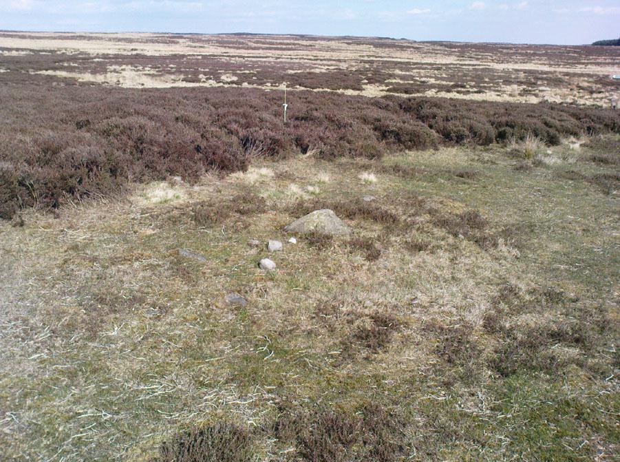
Get here before the heather grows back! From the Askwith Moor parking spot, walk up the road (north) and turn left on the moorland track, past the triangulation pillar, then the ranger’s hut on the edge of the hill, and head WNW along and down the gradual slope. You’ll get to a row of grouse butts after a few hundred yards and, if you’re lucky to find it, an old OS trig-marked arrow carved on one of the low-lying stones. This stone is about 10 yards away from the cairn!
Archaeology & History
There are no previous references to this site. It was discovered by the hardworking Keighley volunteer, Michala Potts of Bracken Bank, on May 20, 2010, and was the most visible of at least three prehistoric cairns on the sloping edge of this hill. The main one illustrated here is about 3 yards in diameter and only a foot or two high. Typical of the many Bronze Age cairns scattering the moors north and south of here, several others are in close attendance. It seems as if some of the stone from this cairn has been robbed to build some of the grouse-butts that stretch across the moors hereby.
Single cairn on Askwith MoorSame cairn, looking uphill
About 50 yards away from the main cairn shown in the photos are a couple of others of the same size and nature. And if we walk over the other side of the nearby rounded hill immediately south, a couple of other cairns are in evidence. However, we didn’t spend too much time here getting any images, as other sites on the moor were beckoning and we were running out of good daylight!
The name of this area seems a little odd: “High Low” — and our old place-name masters say little about it in the Yorkshire directories. The name is shown in the earliest large-scale OS-maps, but the contradiction of a high low ridge probably derives from the word originally being lowe, or “hlaw”: which as A.H. Smith (1956) said,
“In (old english) the common meaning in literary contexts is ‘an artificial mound, a burial mound,'”
Cairn to centre, with 1 more on near horizon
which is exactly what we have found here — or several of them scattered about. This tumulus derivation is echoed by modern place-name authorities like Margaret Gelling (1988), etc. Gelling told how the word hlaw, or low, and its variants, “was used of burial mounds over a wide area, from the south coast to the West Riding.” Much as we’ve found on this hill at Askwith Moor! We’ve yet more exploring to do in and around this area in the coming weeks. God knows what else we’ll find!
References:
Cowling, Eric T., Rombald’s Way: A Prehistory of Mid-Wharfedale, William Walker: Otley 1946.
Gelling, Margaret, Signposts to the Past, Phillimore: Chichester 1988.
Smith, A.H., English Place-Name Elements – volume 1, Cambridge University Press 1956.
From the large parking spot by the roadside along Askwith Moor Road, walk up (north) 250 yards until you reach the gate with the path leading onto Askwith Moor. Follow this along, past the triangulation pillar until you reach the Warden’s Hut near the top of the ridge and overlooking the moors ahead. Naathen — look due south onto the moor and walk straight down the slope till the land levels out. If you’re lucky and the heather aint fully grown, you’ll see a cluster of stones about 500 yards away. That’s where you’re heading. If you end up reaching the Woman Stone carving, you’ve walked 100 yards past where you should be!
Archaeology & History
Discovered on the afternoon of May 13, 2010, amidst another exploratory ramble in the company of Dave Hazell. We were out looking for the Woman Stone carving and a few others on Askwith Moor, and hoping we might be lucky and come across another carving or two in our meanderings. We did find a previously unrecorded cup-marked stone (I’ll add that a bit later) — and a decent one at that! — but a new cairn-field was one helluva surprise. And in very good nick!
Cairn A, looking northwestCairn A, looking east
There are several cairns sitting just above the brow of the hill, looking into the western moors. Most of these are typical-looking single cairns, akin to those found on the moors above Ilkley, Bingley and Earby, being about 3 yards across and a couple of feet high amidst the peat and heather covering. But two of them here are notably different in structure and size (and please forgive my lengthy description of them here).
We found these tombs after noticing a large section of deep heather had been burnt back, and a large mass of rocks were made visible as a result. Past ventures onto these moors when seeking for cup-and-ring carvings hadn’t highlighted this cluster, so we thought it might be a good idea to check them out! As I approached them from the south from the Woman Stone carving (where we’d sat for a drink and some food, admiring the moors and being shouted at by a large gathering of geese who did not want us here), it became obvious, the closer I got, that something decidedly man-made was in evidence here.
Cairn A, looking south
Walking roughly northwards out of the heather and onto the burnt ground, a cairn-like feature (hereafter known as “Cairn A”) was right in front of me; though this seemed to have a ring of small stones — some earthfast, others placed there by people — surrounding the stone heap. And, as I walked around the edge of this large-ish cairn (about 9 yards in diameter and 2-3 feet tall), it was obvious that a couple of these outlying stones were stuck there by humans in bygone millenia. The most notable feature was the outlying northernmost upright: a small standing stone, coloured white and distinctly brighter than the common millstone grit rock from which this monument is primarily comprised. As I walked round it — adrenaline running and effing expletives emerging the more I saw — it became obvious that this outlying northern stone had long lines of thick quartz (or some crystalline vein) running across it, making it shine very brightly in the sunlight. Other brighter stones were around the edge of the cairn. It seemed obvious that this shining stone was of some importance to the folks who stuck it here. And this was confirmed when I ambled into another prehistoric tomb about 50 yards north, at “Cairn B.”
Cairn B, looking northCairn B, looking east
Cairn B was 11 yards in diameter, north-south, and 10 yards east-west. At its tallest height of only 2-3 feet, it was larger than cairn A. This reasonably well-preserved tomb had a very distinct outlying “wall” running around the edges of the stone heap, along the edge of the hillside and around onto the flat moorland. Here we found there were many more stones piled up in the centre of the tomb, but again, on its northern edge, was the tallest of the surrounding upright stones, white in colour (with perhaps a very worn cup-marking on top – but this is debatable…), erected here for some obviously important reason which remains, as yet, unknown to us. Although looking through the centre of the cairn and onto the white upright stone, aligning northwest on the distant skyline behind it, just peeping through a dip, seems to be the great rocky outcrop of Simon’s Seat and its companion the Lord’s Seat: very important ritual sites in pre-christian days in this part of the world. Near the centre of this cairn was another distinctly coloured rock, as you can see in the photo, almost yellow! Intriguing…
The smaller “Cairn C”
Within a hundred yards or so scattered on the same moorland plain we found other tombs: Cairns C, D, E, F, G and H — but cairns A and B were distinctly the most impressive. An outlying single cairn, C, typical of those found on Ilkley Moor, Bingley Moor, Bleara Moor, etc, was just five yards southwest of Cairn A, with a possible single cup-marked stone laying on the ground by its side.
Just to make sure that what we’d come across up here hadn’t already been catalogued, I contacted Gail Falkingham, Historic Environment team leader and North Yorkshire archaeological consultant, asking if they knew owt about these tombs. Gail helpfully passed on information relating to a couple of “clearance cairns” (as they’re called) — monument numbers MNY22161 and MNY 22162 — which are scattered at the bottom of the slope below here. We’d come across these on the same day and recognised them as 16th-19th century remains. The cairnfield on top of the slope is of a completely different character and from a much earlier historical period.
We know that human beings have been on these moors since mesolithic times from the excess of flints, blades and scrapers found here. Very near to these newly-discovered tombs, Mr Cowling (1946) told that:
“On the western slope of the highest part of Askwith Moor is a very interesting flaking site. For some time flints have been found in this area, but denudation revealed the working place about August, 1935. There were found some twenty finished tools of widely different varieties of flint. A large scraper of red flint is beautifully worked and has a fine glaze, as has a steep-edged side-blow scraper of brown flint. A small round scraper of dull grey flint has the appearance of newly-worked flint, and has been protected by being embedded in the peat…One blade of grey flint has been worked along both edges to for an oblong tool… The flint-worker on this site appears to have combed the neighbourhood to supplement the small supply of good flint.”
All around here we found extensive remains of other prehistoric remains: hut circles, walling, cup-and-ring stones, more cairns, even a probable prehistoric trackway. More recently on another Northern Antiquarian outing, we discovered another previously unrecognised cairnfield on Blubberhouse Moor, two miles northwest of here.
References:
Cowling, Eric T., Rombald’s Way: A Prehistory of Mid-Wharfedale, William Walker: Otley 1946.
Jack, Jim, “Ancient Burial Ground and Bronze Age Finds on Moor,” in Wharfedale Observer, Thursday, May 27, 2010.
From East Morton village, take the moorland road, east, and up the steep hill. Where the road levels out there’s a right turn, plus (more importantly!) a trackway on your left which leads onto the moor. Go up this track and keep walking till you hit a moorland ‘footpath’ signpost. Just before this walk due west (your left) into the heather for about 10 yards. Look around! (if the heather’s long and overgrown, you might have trouble finding it) If you find carved stone 109, you’re less than 10 yards off this one!
Archaeology & History
First reported by Stuart Feather and described in a short note of the Yorkshire Archaeological Register* of 1977. This was one of two small carved stones next to each other amidst the “denuded remains of a cairn 3m in diameter and 0.35m high.” The stone we can still see here is a small one, seemingly near the very centre of the cairn, with its carved face looking northwards. The carving is a simple double-ring surrounding a central cup: an almost archetypal cup-and-ring stone.
Crap photo of the double-ring
The other ancient carved stone that was once seen next to this (catalogued as carving 111) has in recent years been stolen by an archaeological thief no less! Any information that anyone might have telling us who’s stolen this heritage piece, or where it might presently reside, can be emailed to me in confidence. Or…the thief who’s taken it can return the carving to the site and put it back where it belongs before we find out where you live. Simple as!
(Soz about the poor photo of this carving. For decent ones of this stone you need to get here when the sun’s in a better position. I’ll hopefully get some better images next time we’re up there when the light’s better.)
References:
Boughey, Keith & Vickerman, E.A., Prehistoric Rock Art of the West Riding, WYAS 2003.
Hedges, John (ed.), The Carved Rocks on Rombalds Moor, WYMCC: Wakefield 1986.
Moorhouse, S. (ed.), “Yorkshire Archaeological Register: 1977,” in Yorkshire Archaeology Journal, volume 50, 1978.
* Does anyone have any idea who you report such new discoveries to so that they can be reported in Yorkshire Archaeology Society’s ‘Register’? I’ve asked ‘em several times about a number of previously unrecorded sites that we’ve located, so that they can make a record of them, but I never get a reply.


")
")