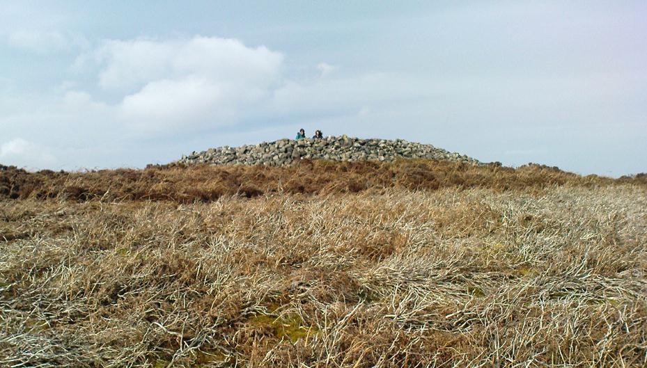
Little Skirtful of Stones, Burley Moor, West Yorkshire

Cairn:  OS Grid Reference – SE 13829 45186

Also Known as:

  1. Little Apronful of Stones

Getting Here

Little Skirtful of Stones, looking north

Probably the easiest way to get here is by starting on the Moor Road above Burley Woodhead, where the road crosses the Rushy Beck stream.  Looking upstream, follow the footpath up the right-hand side of the waters, nearly all the way to the top.  Where it crosses a footpath near where the moor begins to level out, look up to your right and you’ll see the raised crown of stones a coupla hundred yards off path, NNW.  That’s it!

Archaeology & History

This very large Bronze Age cairn was reported by Faull & Moorhouse (1981) to have been surrounded by a multiple stone circle, citing it to have been shown as such on an estate map of Hawksworth Common in 1734. When I contacted the Yorkshire Archaeology Society to enquire about this map, it could not be located. (This needs to be found!) No evidence of such a stone circle presently remains, though there were at least two standing stones once to be seen at the edge of this tomb, though only one of them — now laid more than five-feet long in the heather — is still evident on the western side of this giant tomb.  But anyone who might know anything about the 1734 Estate Map – pleeeeez gerrit copied or take a photo of it! Then stick it on TNA so everyone can see whether the circle surrounded this, or the Great Skirtful of Stones, 500 yards to the south.
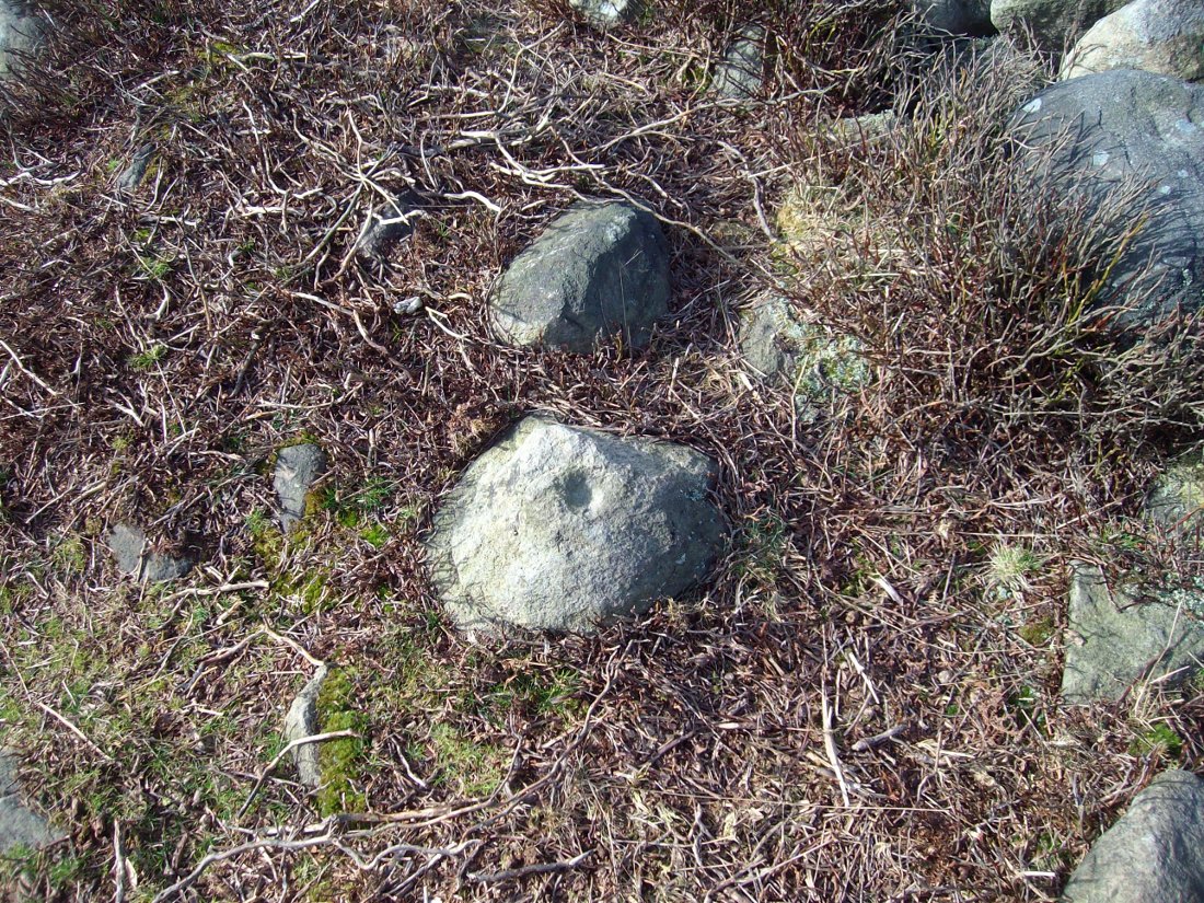
Single cup-marked stone on outer edge of Little Skirtful

The Little Skirtful is in better condition than its big brother on the hill to the south and — unlike the Great Skirtful — there are said to be at least five cup-marked stones amidst the great mass or rocks constituting this site.  There could be more.  The carvings are just single cup-markings etched onto small portable stones, typical of sites like this.  They are found near the centre above a small cist and outwardly towards the northern edges of the cairn (for more info about them, see the main entry for the Little Skirtful Carvings).

It’s been said by Stan Beckensall (1999, 2002) that no cup-marked rocks “are known near…the really large cairns” on the moor—meaning the Little Skirtful and her allies—but this isn’t true as there are at least 4 definite carvings (a possible fifth seems likely) on the moorland immediately around the Little Skirtful.  Though to give Beckensall his due, if he got his data from the Ilkley archaeologists, his information isn’t gonna be too accurate, as they’re quite unaware of many sites on these moors!  A good number of local people have a much greater knowledge-base on such matters than those in paid offices, as this and other websites clearly shows.  The times they are a-changin’, as one dood said, not so long ago…!

Folklore
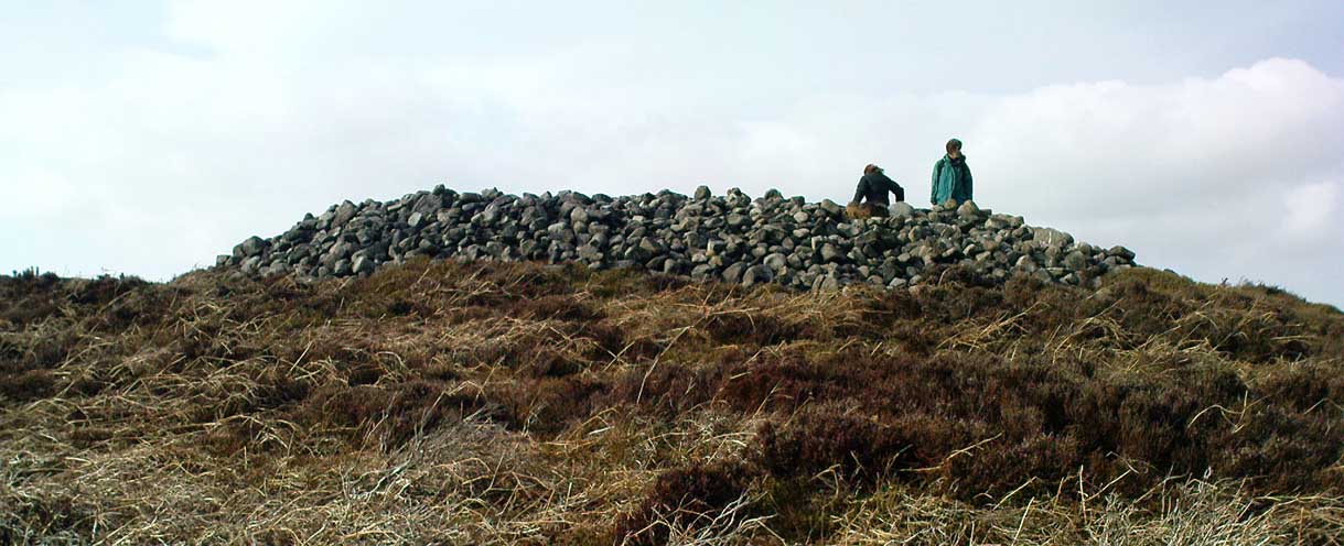
Paul Bowers & Mikki on top for scale!

The creation myth of this place tells that the giant Rombald (who gives his name to the moor) was in trouble with his wife and when he stepped over to Almscliffe Crags from here, his giant wife – who is never named – dropped a small bundle of stones she was carrying in her apron. (In traditional societies elsewhere in the world where this motif is also found, it tends to relate to the site being created by women.) Harry Speight (1900) tells us of a variation of the tale,

“which tradition says was let fall by the aforementioned giant Rumbalds, while hastening to build a bridge over the Wharfe.”

Variations on this story have said it was the devil who made the site, but this is a denigrated christian variant on the earlier, and probably healthier, creation tale. Similar tales are told of the Great Skirtful of Stones, 500 yards south.

References:

  1. Beckensall, Stan, British Prehistoric Rock Art, Tempus: Stroud 1999.
  2. Beckensall, Stan, “British Prehistoric Rock Art in the Landscape,” in G. Nash & C. Chippindale’s European Landscapes of Rock Art, Routledge: London 2002.
  3. Bennett, Paul, The Old Stones of Elmet, Capall Bann: Chieveley 2001.
  4. Boughey, Keith & Vickerman, E.A., Prehistoric Rock Art of the West Riding, WYAA 2003.
  5. Collyer, Robert & Turner, J. Horsfall, Ilkley: Ancient and Modern, William Walker: Otley 1885.
  6. Colls, J.N.M., ‘Letter upon some Early Remains Discovered in Yorkshire,’ in Archaeologia 31, 1846.
  7. Cowling, E.T., Rombald’s Way, William Walker: Otley 1946.
  8. Faull & Moorhouse, West Yorkshire: An Archaeological Survey – volume 3, WYMCC: Wakefield 1981.
  9. Hedges, John (ed.), The Carved Rocks on Rombalds Moor, WYMCC: Wakefield 1986.
  10. Speight, Harry, Upper Wharfedale, Elliott Stock: London 1900.
  11. Wood, Butler, ‘Prehistoric Antiquities of the Bradford District,’ in Bradford Antiquary, volume 2, 1901.

© Paul Bennett, The Northern Antiquarian

Gariob Cottage, Achnamara, Knapdale, Argyll

Cairn:  OS Grid References – NR 7801 8910

Getting Here

From Lochgilphead go north up the A816 for just over a mile, turning left going through Cairnbaan to Bellanoch, where the road bends left up the B8025 into the trees. Keep along here for a mile and when the small road appears on your left, follow it for just over a mile till you see the cottage on the roadside with the loch at tha far end of the garden. There’s a small path besides the cottage. Walk along here for 100 yards until you see the small cairn on your left.

Archaeology & History

This is a beautiful quite place with only a small pile of stones here, about 100 yards west of Gariob Cottage on the ridge overlooking Loch Sween.  The remains of the cairn here are about 20 feet across (or were when I last came here nearly 20 years ago!).   Excavations here in 1977 and 1978 found a small cist split into 2 sections, just off-centre, aligned northwest.  The lower part of the cist was filled with small stones and charcoal; whlst the larger section had the same with additional quartz stones in it.

References:

  1. Royal Commission on the Ancient & Historic Monuments of Scotland, Argyll – volume 6, HMSO: Edinburgh 1988.

© Paul Bennett, The Northern Antiquarian

Green Crag Top Cairns, Ilkley Moor, West Yorkshire

Cairns:  OS Grid Reference – SE 131 458

green-crag-top-cairn02-sm
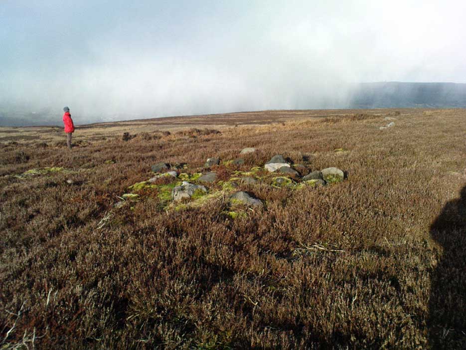
Larger of the Green Crag Top cairns – with blizzard in background!

Getting Here

Follow directions for getting to the Haystack Rock.  Once here, walk dead straight south onto the moor and go up the slope you see a few hundred yards ahead of you.  Once you’re at the top of the slope, a few yards onto the ridge itself, look around!  If there’s deep heather growth when you arrive, you’ve no chance!

Archaeology & History

To my limited knowledge, it appears there’s no previous references to the cairns here.  We found at least two of them, with a probable third not far away; but we were lucky inasmuch that the heather had all been burnt away, allowing a clearer inspection of the sites.  The larger of the two is nearly four yards across and nearly a yard high.  It’s somewhat larger than the majority of what are thought to be single-person cairns along Green Crag Slack ridge, down the slope.

Much denuded cairn
Much denuded cairn

A smaller cairn less than 100 yards west on the same ridge (near the large boulder with a couple of cup-markings on top) looks as if it was robbed of stone sometime in the past.  About six-feet across, this one is more typical of the cairns found on the Ridge below.

There are what seems to be other remains along this ridge, including a very distinct thin, six-foot-long stone, which looks very much as if it could have stood upright in the not-too-distant past.  We could do with more heather-burning on this part of the moor to help us out!

© Paul Bennett, The Northern Antiquarian

Haulgh, Bolton, Lancashire

Tumulus (destroyed):  OS Grid Reference – SD 7242 0899

Archaeology & History

This single-grave burial — described by Barnes (1982) as a kerbed or revetted cairn — close to the very centre of modern-day Bolton, was once an impressive prehistoric tomb.  It was described by a local historian, Matthew Dawes, amidst a variety of prehistoric remains in and around Bolton, most of which have long-since been forgotten.

“Near Haulgh, about a quarter of a mile south-east from Bolton Parish Church, on a piece of high flat land, on the east bank of the Croal, and about fifty feet above the river, was a tumulus, about thirty feet in diameter, and four feet deep, consisting of small boulders… It was discovered in September, 1826, in forming a branch of the new road leading from Bolton to Bury. It was probably much depressed in its formation and was covered with a few inches of mound. The cop or fence crossed it in a north and south direction. About the centre of this tumulus was a cist-vaen, about four feet six inches long and one foot deep, formed of four upright stones and a coverer, and its length was nearly north and south. In this cist-vaen was a skeleton, with the legs doubled up, and the head to the north. Near the head, and on the west side, was found an urn, inverted, four and a half inches in the widest diameter, and three and a quarter inches high, and perforated by four small holes in the widest part. On the other side of the head was a bronze spear-head, four and three-eighths inches long, and one and three-eighths inch wide, of which the point was bent back, and a piece of the side chipped away. The urn and spear-head were taken to the Countess of Bradford, the Earl of Bradford being the owner of the land.”

Intriguingly, if you’re from the Bolton region, Mr Dawes also told that, “A man in the employ of the Earl of Bradford, the superintendent of the work, who made the discovery, informs me (1862) that two other tumuli were found shortly after the one just described, a few yards to the south of it, in the same fence.”  As yet I have no more information about these other tombs (gimme time though!)

References:

  1. Barnes, Bernard, Man and the Changing Landscape, Unversity of Liverpool 1982.
  2. Dawes, M., ‘British Burial Places near Bolton,’ in Trans. Hist. Soc. Lancs & Cheshire, volume 4, 1852.
  3. Scholes, James C., History of Bolton, Daily Chronicle: Bolton 1892.

© Paul Bennett, The Northern Antiquarian

Ardminish, Gigha, Argyll

Cist:  OS Grid Reference – NR 6495 4890

Also Known as:

  1. Canmore ID 38528

Archaeology & History

When the Scottish Royal Commission lads came here in 1963, they reported seeing

“the remains of a short cist…set into the west side of a small turf-covered knoll some 18 metres north of the schoolhouse at Ardminish.”

It was first found during quarrying operations here, and was thankfully kept pretty well preserved, apart from the western slab, which was dislodged and fell to the foot of the knoll. The cist aligns roughly north-south (the airt, or cardinal virtue of ‘death’ is north) and measured about 3 feet long by 2 feet wide.

References:

  1. Royal Commission on the Ancient & Historical Monuments, Scotland, Argyll: volume 1 – Kintyre,  HMSO: Edinburgh 1971.

© Paul Bennett, The Northern Antiquarian
Stoodley Pike Circle, Mankinholes, West Yorkshire

Ring Cairn (destroyed):  OS Grid Reference – SD 9730 2418

Getting Here

Stoodley Pike is unmissable! Get to either Hebden Bridge or Todmorden – ask someone – then get to it! Nice climb – nice view – excellent moors all round!

Archaeology & History

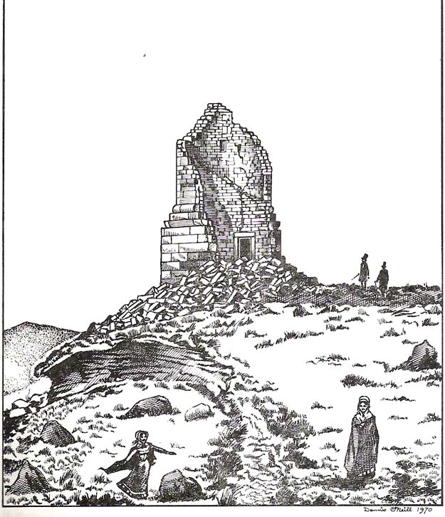
Artist’s impression of Stoodley Pike Circle (bottom left of ruin)

All traces of this site have gone, but local gossip still tells there was once something here. When building work commenced on the huge folly in 1814, in clearing the ground “an accumulation of stones (and)…a quantity of bones” were unearthed. After the huge folly had been built, a curious ritual was made by local Freemasons, from here to the nearby Slake Well. The circle was only a small one, but ideal for the spirit of the ancestor to both look-out from, and fly across the landscape.  In another description of the place from 1832 — wrote E.M. Savage (1974) — local writer and poet, William Law, told how “a rude heap of stones had stood on the site from time immemorial.”

Folklore

Suggested by earlier writers to have been an old beacon site, though evidence for this is uncertain.  The site was said to be a meeting place of the “gude grannies,” who met here and told old stories.  E.M. Savage (1974) told us:

“Another story was that the cairn marked the grave of an old chietain and that the bones of a human skeleton had been found… A contemporary of (William) Law, called Holt…stated that this was so.  Another story was that someone had been murdered and buried there.  Many years later, Law quizzed the workmen.  Bones had been found but no one knew whose bones, or their age, so the mystery remained.

“Yet another story had it that the occupant, presumably owner, of Stoodley, had to keep the original Pike, the cairn, in neat and good order.  If a single stone was out of place, no one could sleep.  The banging of doors and other noises started up, to remind the owner to tidy up the stones.  Elusive flames were to be seen playing round the stones. Sor the stories went.”

As can be seen in the artist’s drawing above, done more than a century after the cairn had been destroyed, a ring of stones is shown just below the remains of the earlier of the Peace Monuments, which today carries the old name of Stoodley Pike.

References:

  1. Booth, Thomas, Ancient Grave Mounds on the Slopes of the Pennine Range, R. Chambers: Todmorden 1899.
  2. Savage, E.M., Stoodley Pike, Todmorden Antiquarian Society 1974.

© Paul Bennett, The Northern Antiquarian


Skirtful of Stones, Horton-in-Ribblesdale, North Yorkshire

Cairn (destroyed):  OS Grid Reference – SD 785 747

Getting Here

Although apparently long gone, we could find this giant prehistoric tomb on the eastern side of the great Ingleborough and was one of many with this name once scattering the mid-Pennines. It was found less than a mile south of the hamlet of Selside, a few miles above Horton-in-Ribblesdale, on the west side of the B6479 and its existence is thankfully preserved in the place-name, ‘Borrens’, where the giant tomb was once found, 200 yards south of Gill Garth Farm.  If you look on the OS-map, you’ll notice an ancient settlement site close by.

Archaeology & History

In 1892, the great Yorkshire historian Harry Speight told us:

“We have no proper account of it, but it was doubtless ransacked and removed in the expectation of finding treasure. It is mentioned…in the Gentleman’s Magazine for 1761, as follows:

‘In the valley above Horton, near the base of this mountain (Ingleborough), I observed a large heap or pile of greet-stones all thrown promiscuously together, without any appearance of building or workmanship, which yet cannot be reasonably thought to be the work of Nature. Few stones are found near it, though ’tis computed to contain 400 of that country cart-loads of stones, or upwards. There is likewise another at the base north-east, in resemblance much the same, but scarce so large.'”

Speight speculated that it may have been raised to commemorate “some dire conflict between the Romans and the native hill tribes, as it lay on the old Roman thoroughfare across Ribblehead to the camp under Smearside.” We may never know this for sure, but there are plenty of Iron- and Bronze Age remains scattering this region – and just a few hundred yards south of this lost cairn are the old remnants of an ancient settlement…whose pages and images (it is hoped) will appear on TNA in the near future…

References:

  1. Smith, A.H., English Place-Name Elements, volume 1, Cambridge University Press 1956.
  2. Smith, A.H., Place-Names of the West Riding, volume 6, Cambridge University Press 1961.
  3. Speight, Harry, The Craven and Northwest Yorkshire Highlands, Elliott Stock: London 1892.

© Paul BennettThe Northern Antiquarian 


Scale House, Rylstone, North Yorkshire

Tumulus:  OS Grid Reference – SD 97088 56870

Getting Here

Pretty simple really.  Go up the B6265 Skipton-Rylstone road for about 3 miles, past the Nettlehole Ridge woodland on your right.  The next turn along to your right, up the track, is Scale House.  Go past this until you get to Scale House Farm.  The remains of the burial mound is in the field to your left, just before the farm.  Knock on the door and ask!

Archaeology & History

This ‘tumulus’ (as it’s marked on the OS-map) was one of the many explored by the legendary reverend William Greenwell (1864) in the middle to latter-half of the 19th century.  His description of the finds at Scale House were considerable; thankfully our old Yorkshire antiquarian Edmund Bogg (1904) shortened it and told us the following:

“The tumulus was 31 feet in diameter and about 7 feet high; it opened from the southeast; the soil immediately under the sod consisting of yellow clay to a considerable depth; then layers of blue clay… Exactly in the centre…at a depth of 7 feet, and on a level with the plane of the field, was found an oak coffin, formed out of a tree, split and hollowed-out, and placed due north and south, the head being placed to the south, as that as the larger part of the tree. After being exposed to the air for about 2 minutes, the bared coffin parted at the sides, and could not be moved except by detached pieces. The body had been wrapped in a cloth or shroud of texture resembling wool and coarsely-woven, of which there was a considerable quantity remaining; but the body itself was dissolved… The interment was considered to be that of an ancient Briton… The learned antiquary said it was the only instance (except the one at Gristhorpe, near Scarborough) where an interment in an oak tree hollowed out had a tumulus placed over it. It was more than 6 feet in length inside and about 7 feet 6 inches outside. The remains were carefully replaced and the mound restored to its former shape; a small leaden tablet being placed within, stating that it had been opened in AD 1864.”

Folklore

Jessica Lofthouse (1976) listed this as one of the places reputed to be an old fairy haunt, wherein “the folk of Scale House discovered a fairy kist or chest.”

References:

  1. Bogg, Edmund, Higher Wharfeland, James Miles: Leeds 1904.
  2. Greenwell, William, British Barrows, Clarendon Press: Oxford 1877.
  3. Lofthouse, Jessica, North Country Folklore, Hale: London 1976.

Links:

  1. Out of Oblivion: Archaeology and Notes – Directions and notices on this once giant tomb.

© Paul Bennett, The Northern Antiquarian


Ringstones, Lowgill, Lancashire

Stone Circle (destroyed): OS Grid Reference – SD 664 655

Archaeology & History

I have found no archaeological references whatsoever to this site (though to be honest, the Lancashire archaeological fraternity are pretty poor when it comes to finding and recording sites).  The place has its existence preserved in the aptly-named Ringstones Lane and the farmhouse, Ringstones.

Michala Potts found several records of the place in the 17th century, and the site is shown on the 1844 OS-map with the same name, but we have been unable to ascertain when/if any standing stones were here.  The place may well have been a burial-site of some sort, as found at other Ringstone place-names in Lancashire.  But we can clearly see on aerial imagery that there is a large, distinct, circular outline in the heavily ploughed fields about 100 yards north of the farm.  There is what may be the remains of a second circle above this, but the outline is faint; but it appears that an enclosure of some sort, ovoid in shape and a couple of hundred feet across, was also evident in the same field where the more distinct circular outline is seen.

My favourite outline however, is a large linear mark on the ground stretching for several hundred yards running roughly north-south, starting in the field between Aikengill and Ringstones and going dead straight, bypassing the circle and crossing Ringstones Lane, where it seems to disappear and is no longer visible.  The curious ‘ground line’ is roughly 100 feet across.  Cursus anyone!?

© Paul Bennett, The Northern Antiquarian


https://wtp2.appspot.com/wheresthepath.htm?lat=54.084767&lon=-2.514329&lz=14&rz=15&lt=OS&rt=satellite&lov

Nixon’s Station, Ilkley Moor, West Yorkshire

Cairn:  OS Grid Reference – SE 11468 45224

Getting Here

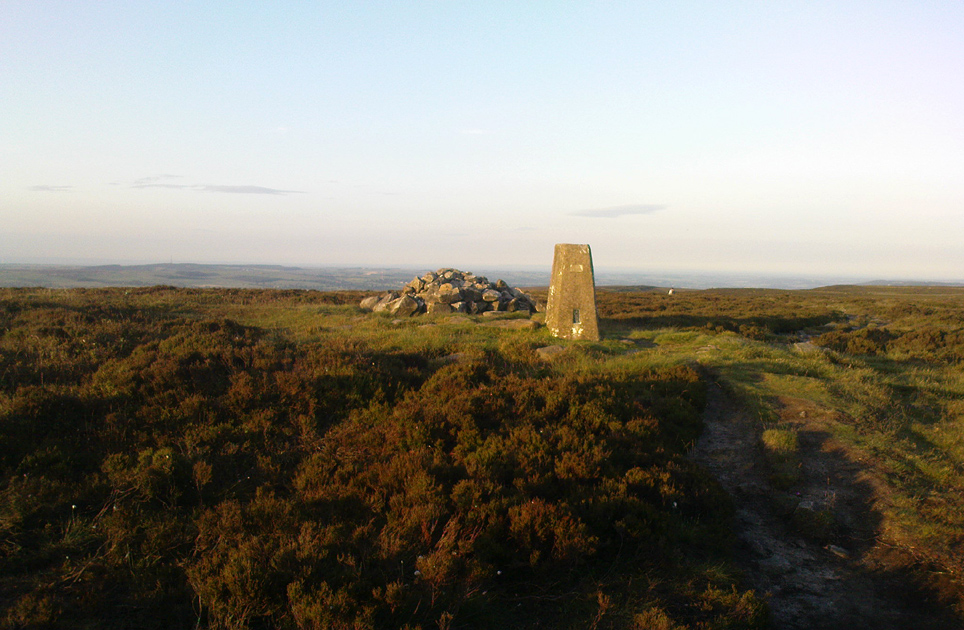
The denuded remains of a once giant tomb

This is the highest point of the moors, 1320 feet up. There’s various ways of getting there: I’d favour the wander up to Twelve Apostles then taking the 15 minute walk west to the triangulation point which marks the spot.  If you reach the large rocky outcrop of the Thimble Stones, you’ve gone too far; although you can walk past the Thimbles, if you’ve started your walk from the two radio masts atop of the moor where the old Roman road hits the dirt-track.  Either way, unless you’re damn stupid, this is an easy spot to find!

Archaeology & History

Although today there’s little to be seen, when Collyer & Turner (1885) described the place it was 175 yards in circumference! Bloody huge! When Harry Speight got here in 1900, it had shrunk slightly to 150 yards. Now however, almost all the stones have been robbed.  I first came here when I was just 11 years old and remember it was a decent size even then – at least as large as the Little Skirtful and Great Skirtful of Stones more than a mile to the east.  Today however, unless you knew it was once a giant cairn, you wouldn’t give it a second look.

It’s quite appalling what’s happened to this site thanks to the sheer ignorance and neglect of the local archaeologist in tandem with his paymasters at Bradford Council: 90% of the site has been utterly vandalised and destroyed as a result of these incompetent idiots in the last 20 years.  Nowadays, all you can make out here is the raised earth for about 10 yards surrounding the trig-point.  It seems that most of the stones that comprised this giant cairn have been taken for use in walling, and to prop up the stupid paved footpaths which the local Council and its affiliated halfwits are slowly building o’er these hills.*  Morons!

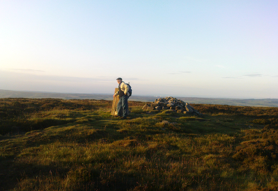
Aar Dave on top o’ t’ moors

I’m not quite sure why it was called Nixon’s Station.  It was J. Atkinson Busfield (1875) who mentioned this name, quite casually in his fine local history work, as if local folk had known it as such for sometime.  There was also an inference of it being the resting place of some old general, but I’ve found nor heard anything more along such lines — though worra superb place for your spirit to roam free…..

If anyone has any old photos of this once giant prehistoric site, it would be good to see it in its old glory once again.  When I wandered up here as a kid, I never carried things like a camera about (being a Luddite by nature!).

References:

  1. Busfield, J.A., Fragments Relating to the History of Bingley Parish, Bradford 1875.
  2. Collyer, R. & Turner, J.H., Ilkley, Ancient & Modern, Otley 1885.
  3. Speight, Harry, Upper Wharfedale, London 1900.

© Paul Bennett, The Northern Antiquarian

* Anyone know exactly which idiots are responsible for the stone footpaths being laid over the moors here? They’re damn stupid and cause even more erosion and damage to the environment and prehistoric heritage up here, as anyone with an ounce of common sense can see. Can someone please get them stopped!?