James Stone, Blubberhouses Moor, North Yorkshire

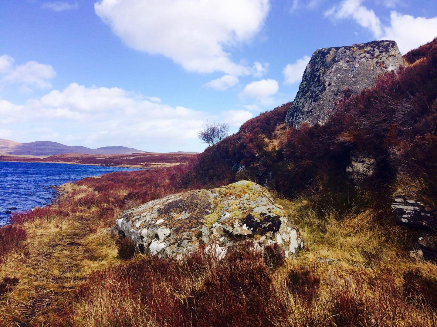
Standing Stone: OS Grid reference – SE 15196 54722

Getting Here

James Stone, looking SW

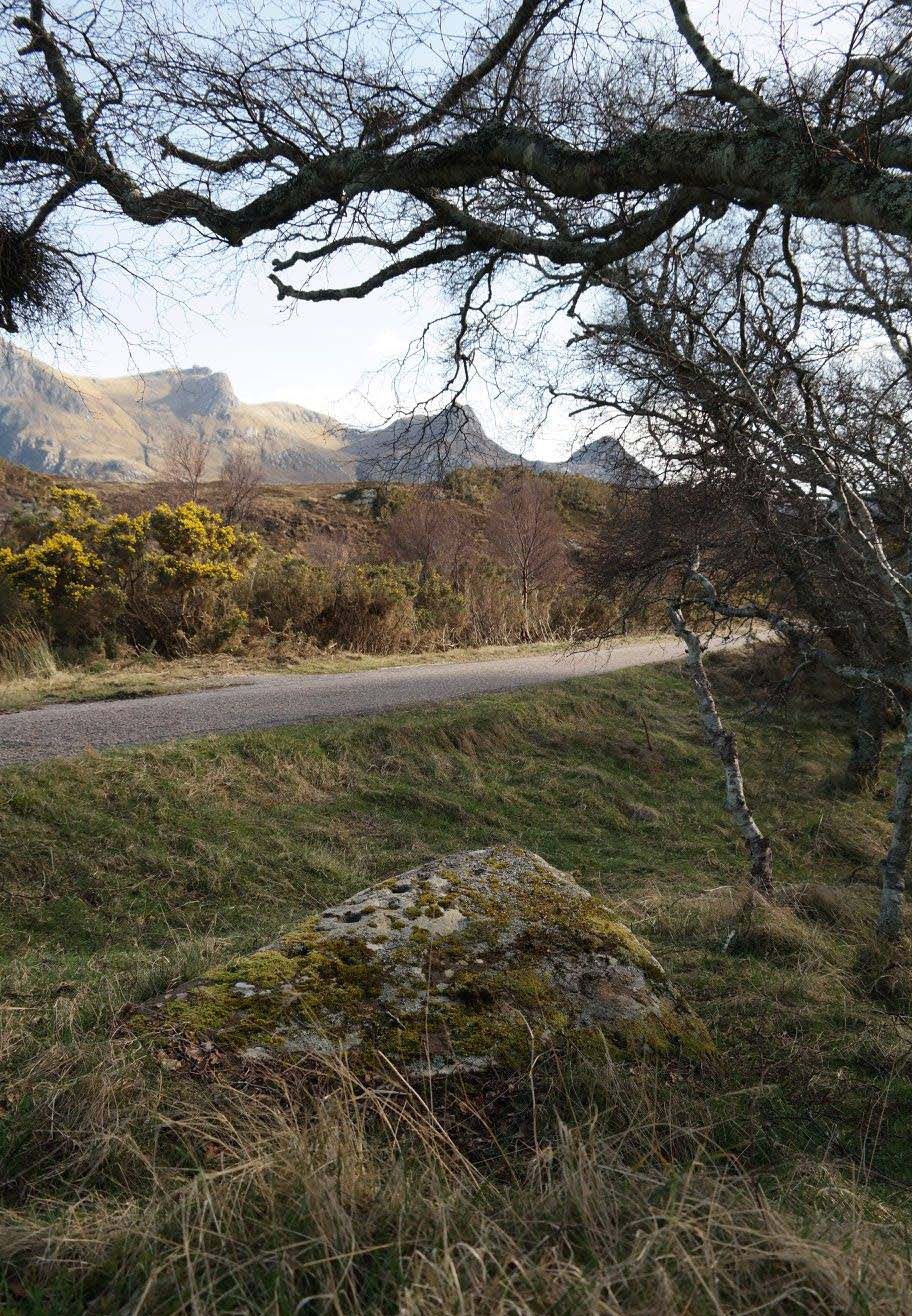
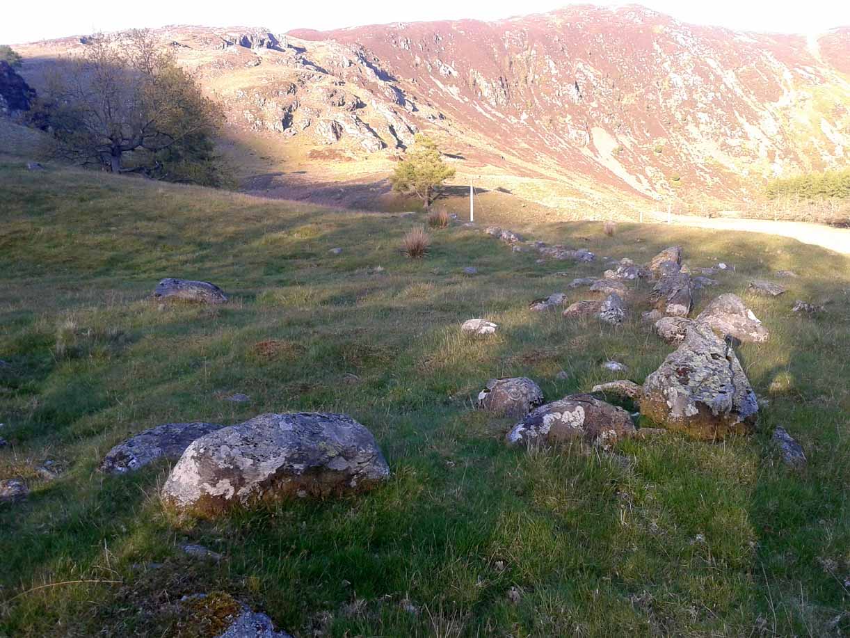
From Blubberhouses church by the crossroads, walk up the slope (south) as if you’re going to Askwith, for 100 yards or so, taking the track and footpath past the Manor House and onto the moor.  Once you hit the moorland proper, take the footpath that bears left going down into heather and keep going till you hit the dead straight Roman Road path running west onto Blubberhouses Moor. Carry along the Roman Road for about 200 yards as though you are going towards the Eagle Stone, and looking right (if you squint) you can just make out a small pimple on the top of the moors about a quarter of a mile away. That is where you are heading (be warned – it is boggy getting there).

Archaeology and History

James Stone, looking NE

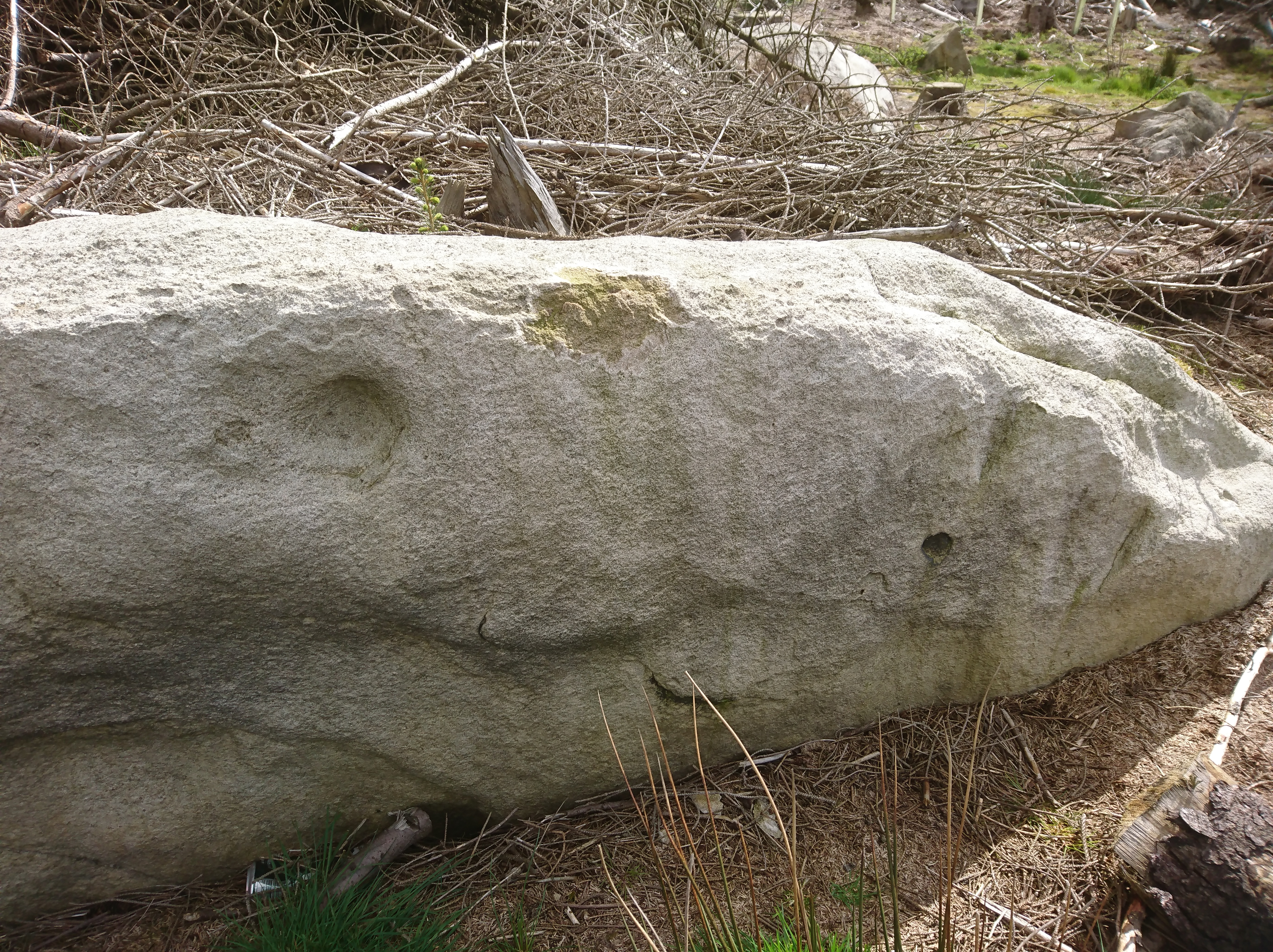
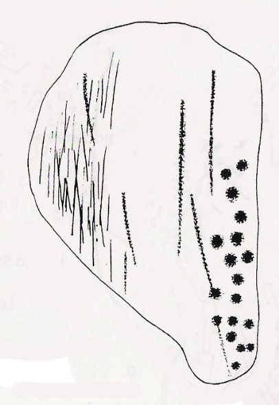
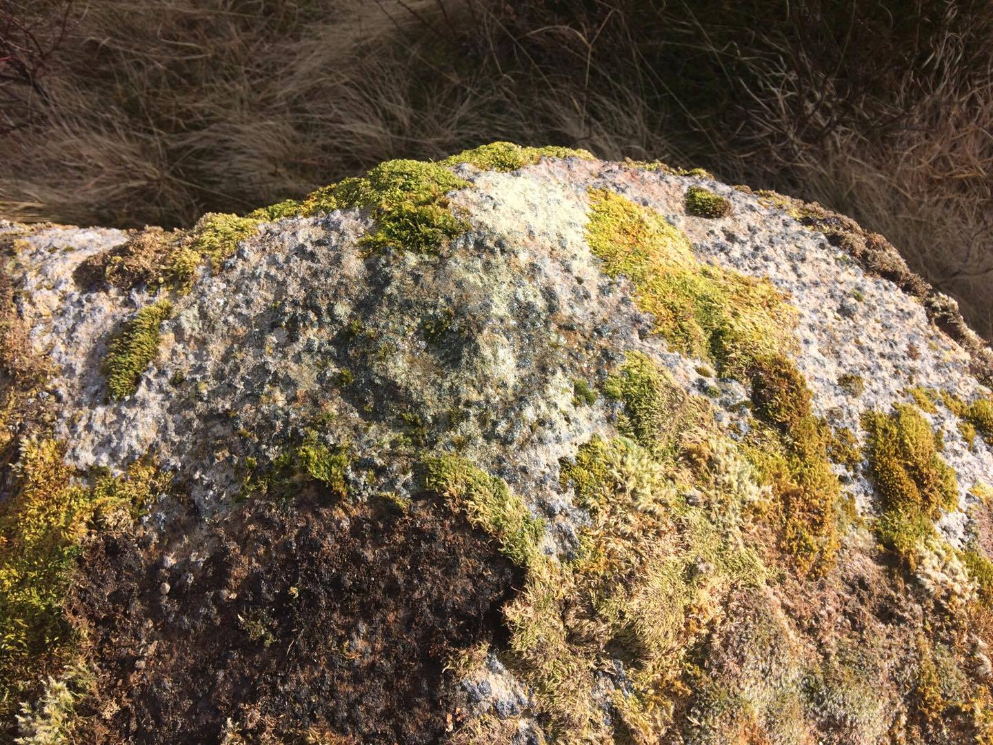
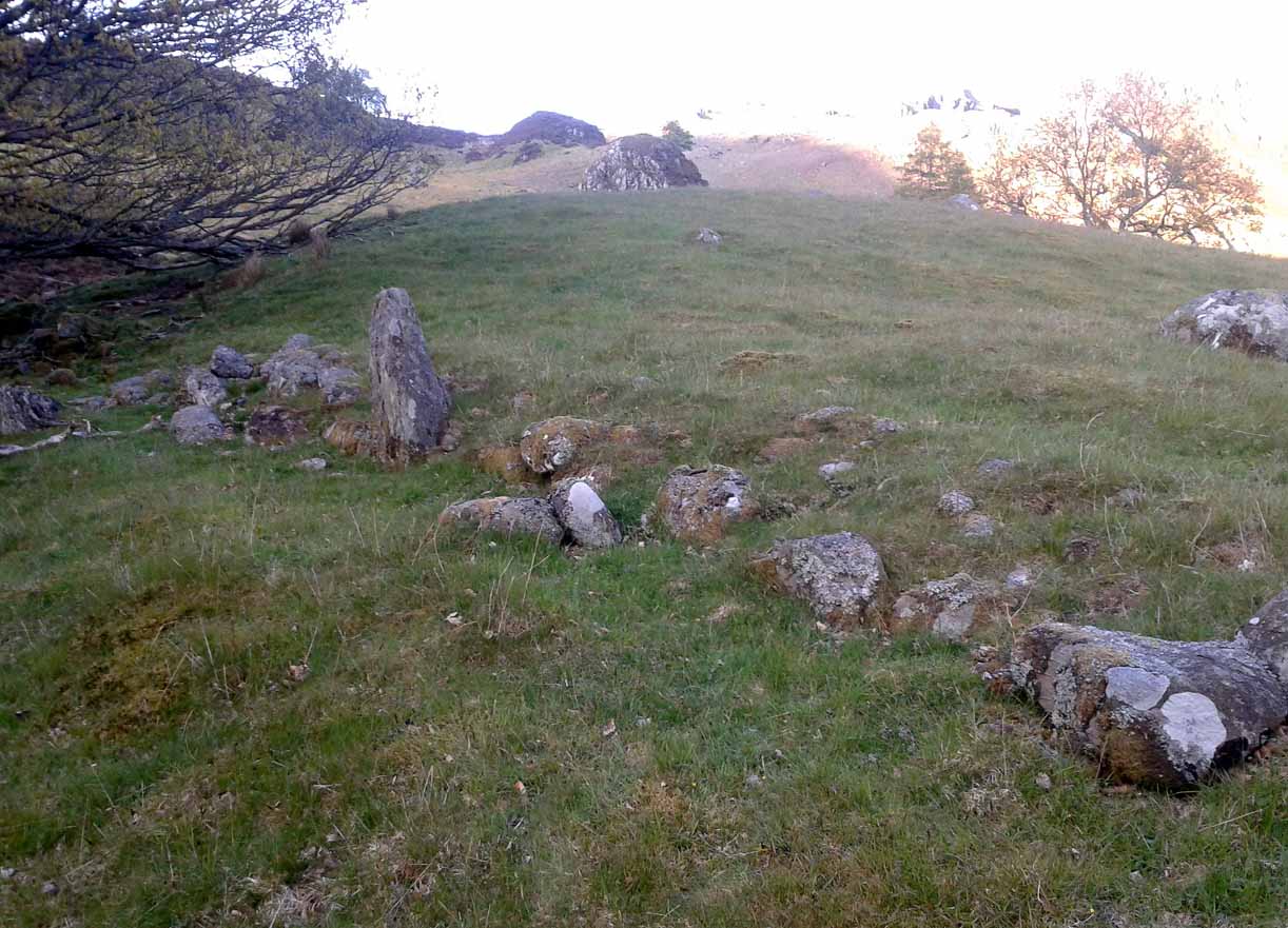
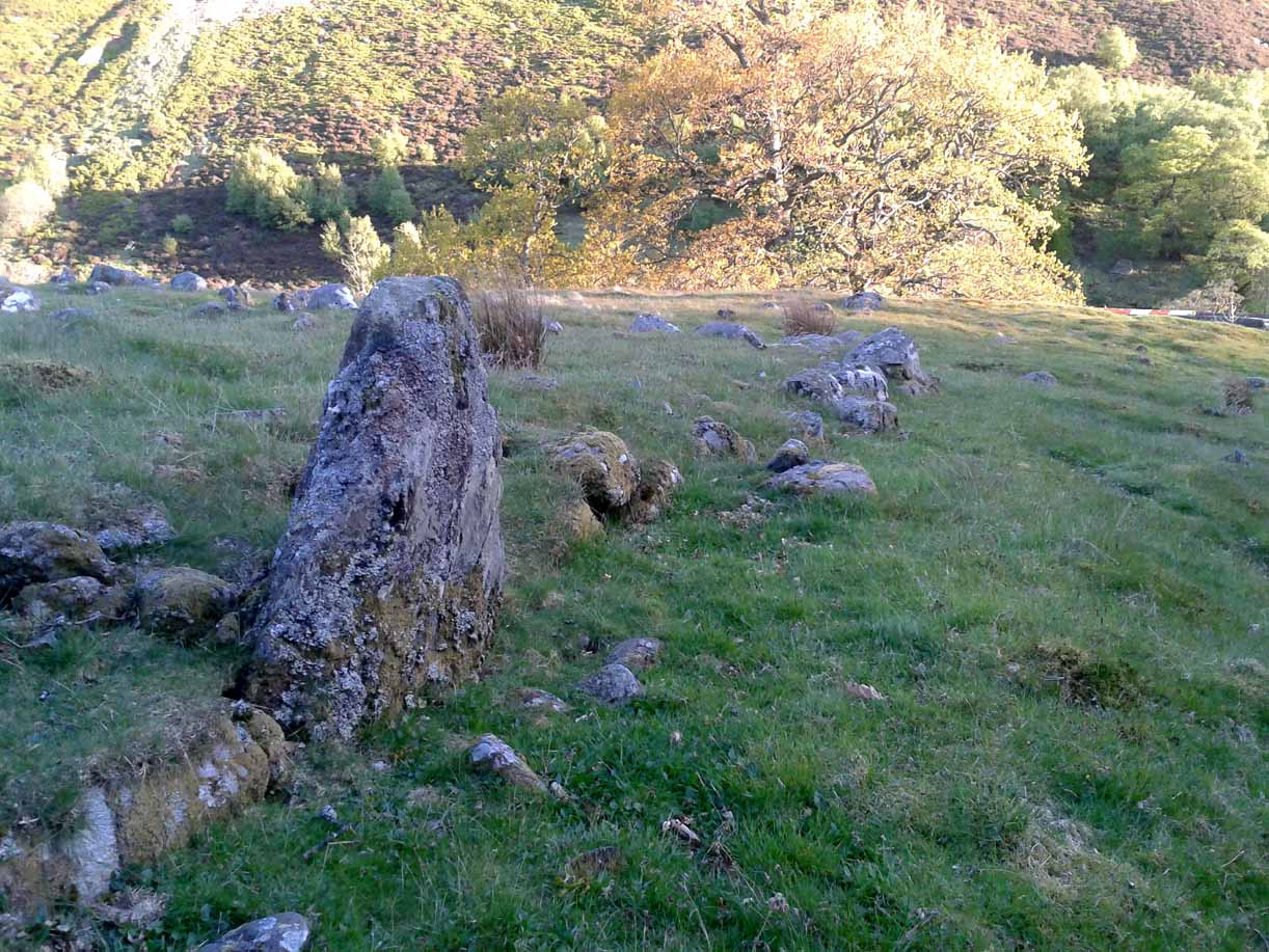
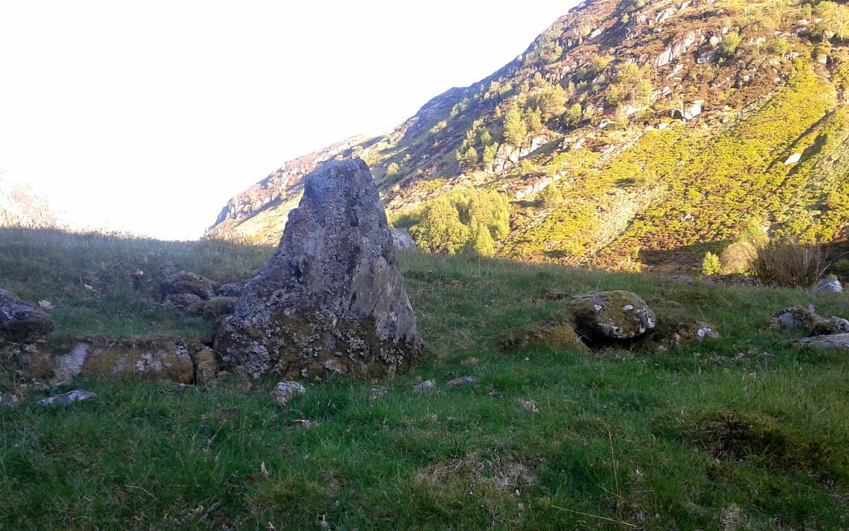
Discovered (or rather ‘noticed’) by James Turner and James Elkington in July 2016 (hence the name James Stone), this standing stone is of an indeterminable age – although it does look ancient.  Standing more than 5 feet tall, and in the middle of nowhere, it is fairly difficult to get to unless you want to get wet feet.  It is situated very close to a small and unexcavated prehistoric settlement and we could find no physical evidence of any tracks nearby (although Google Earth does show what looks like one or two very short, faint tracks near the stone, which is the old ‘Benty Gate’ track).

It could be a boundary stone, although doubtful – it has a feel to it that says it is prehistoric, although this is just guesswork on our part.  I can find no reference to it in Cowlings Rombalds Way (1946) and there seems nothing about it in either of William Grainge’s (1871; 1895) detailed history works of the region.

Mr Turner gazing at the stone

At first we thought it unlikely to be a new find, however the stone is difficult to see from the Roman Road (I had been up here dozens of times before I noticed it) and seeing that people rarely go up here anyway, and it is relatively difficult terrain getting to it, it is not surprising that no one has bothered visiting it. It would take someone who is quite keen on megaliths to want to examine it and it is well off any tracks.

Having said that, it is a nice find and it could be linked in some way with the small unexcavated settlement nearby, or possibly the large Green Plain settlement nearly a mile away.  Well worth a visit…bring your wellies!

References:

  1. Cowling, Eric T., Rombald’s Way, William Walker: Otley 1946.
  2. Grainge, William, The History and Topography of Harrogate and the Forest of Knaresborough, John Russell Smith: London 1871.
  3. Grainge, William, The History and Topography of the Townships of Little Timble, Great Timble and the Hamlet of Snowden, William Walker: Otley 1895.

© James Elkington, The Northern Antiquarian

The map could not be loaded. Please contact the site owner.


Lower Rivock, Keighley, West Yorkshire

Cup-and-Ring Stone:  OS Grid Reference – SE 0717 4471

Getting Here

Faint Lower Rivock cup-and-ring

From the B6265 valley road between Bingley and Keighley, just near Riddlesden Hall, take the road up and over the canal into Riddlesden, bearing left up past West Riddlesden Hall and up Banks Lane. As you reach the T-junction at the top, where you hit the Silsden Road that goes round the moors, park up. Cross the road and follow the footpath up the field, go over a stile and continue up the track to the next gate. Once through this gate, go across the field to another gate which leads to a narrow track. The stone is situated on the left hand side about 75 yards from the gate.

Archaeology & History

Not previously recorded, this carving comprises of a large cup on the vertical surface of the stone with a faint surrounding ring mark.

© Chris Swales, The Northern Antiquarian

The map could not be loaded. Please contact the site owner.


Achnaburin, Bettyhill, Farr, Sutherland

‘Hut Circle’:  OS Grid Reference – NC 7082 5891

Also Known as:

  1. Achnabourin
  2. Canmore ID 6210

Getting Here

Site as ‘Picts House’ on 1873 map

Take the A836 road (between Bettyhill and Tongue), crossing the metal bridge across the River Naver a mile south of Bettyhill.  Keep going for nearly a mile, past the houses and into the small trees, keeping your eyes peeled to the right where a small but notable bracken-covered mound rises 10-20 yards in the rough field. Go through the gate and you’re there!

Archaeology & History

Low stone wall along S side

A site which, from the nearby roadside, has all the hallmarks of being yet another Sutherland broch (there are tons of them up here!)—but apparently it isn’t!  Despite being shown on the earliest OS-map of the region as a ‘Pict’s House’ (which are usually brochs), the site has subsequently been designated by modern archaeologists as a simple ‘hut circle’.  I have my doubts over this, as it’s a most unusual one with little logic over its positioning—unless it was either a look-out point, or an odd ritual spot.

The south side of the mound

As you can see from the poor photos I got of the place, a large angled tumulus-like hillock (it’s akin to a mini-Silbury Hill at first sight) rises up from the ground with a reasonably uniform angle around much of it, to a height of between 16-20 feet.  Scattered rocks and stones adorn the mound as you walk up its embankments and onto the top where, around the edges, a notable man-made ring of walling shows it to have been artificially created.  Unfortunately most of the top of the mound was completely covered in thick decayed bracken when I visited, so it was difficult to get any good photos of this topmost walling.

The SE side of the mound

From the top of the mound, the walling is between 1-3 feet high, in a roughly circular setting, measuring 36-40 feet across.  The most distinct section of it was visible on the west-to-south-to-east section; with the lowest and depleted section occurring on its northern edges.  The entrance to the ‘hut circle’ is apparently on its eastern side.  Although it is assumed to be Iron Age in nature, its real age is unknown.

References:

  1. Mercer, R.J. & Howell, J.M., Archaeological Field Survey in Northern Scotland – volume 2, University of Edinburgh 1976-1983.

© Paul Bennett, The Northern Antiquarian

The map could not be loaded. Please contact the site owner.

Kinloch Lodge, Tongue, Sutherland

Cup-Marked Stone:  OS Grid Reference – NC 56201 52713

Also Known as:

  1. Canmore ID 5356
  2. Lochan Hakel A (Gourlay 1996)

Getting Here

Kinloch Lodge carving (by Donna Murray)

Whether you take the A836 or A838 into Tongue (through truly beautiful wilderness), make sure you go into the village itself—and then keep going, south, along the tiny country road for 3 miles.  Hereby, keep your eyes peeled for Lochan na Cuilce on your right; keep going past here, into and through the old trees where you’ll then see Lochan Hakel on your left.  Keep going past here until your reach the next small copse on your right.  Stop here.  A small pool is yards into the trees and here you’ll see a single stone between that and the roadside.  You can’t really miss it!

Archaeology & History

Close-up of some cups (by Donna Murray)

An apparently isolated cup-marked stone, some 3 feet by 5 feet, that was first described in Morrison’s (1883) meanderings amidst Sutherland’s awesome wilderness.  It’s quite plain compared to Lochan Hakel 2 and many other carvings, simply consisting of 18 cups of various sizes, mainly on the eastern side of the rock.  Sarah MacLean pointed out that a line running along the length of the stone seemed, in parts, to have been artificially enhanced by the hand of man, or woman.  I have to agree with her.

The Royal Commission (1911) lads included this petroglyph in their superb survey of Sutherland, telling:

“On the W. side of the road to Kinloch, about ½ m. N of the bridge over the Kinloch River (Amhainn Ceann Locha), and on the N edge of a gravel pit close to the road, is a large earthfast boulder, 5′ in length as far as exposed, and 3′ 10″ in breadth, showing on its upper surface eighteen cup-marks of various depths, of which the most distinct is towards the N end of the stone, measuring about 3″ in diameter and 1″ in depth.  The whole length of the stone is not visible, but the markings do not seem to extend to the portion covered…”

Carving in situ (by Donna Murray)
by Kevin o’ Reilly

Simulacra lovers will love the form of this stone in relation to the background of the mountains, as its shape is echoed in that of the rising hills several miles to the south.  …Of course, the depersonalizing ones amongst you lacking an understanding of animism would reject any such association due to your projection of disbelief.  However—and equally—as we lack any ethnographic data on the carving we must also assume some caution…

A fascinating site – and one which is likely to have neighbours hidden in the surrounding moorlands…

References:

  1. Gourlay, Robert, Sutherland: An Archaeological Guide, Birlinn: Edinburgh 1996.
  2. Michell, John, Simulacra, Thames & Hudson: London 1979.
  3. Morrison, Hew, Tourist’s Guide to Sutherland and Caithness, D.H. Edwards: Brechin 1883.
  4. Royal Commission on Ancient & Historical Monuments, Scotland, Second report and inventory of monuments and constructions in the county of Sutherland, HMSO: Edinburgh 1911.

Acknowledgments:  Huge thanks to Donna Murray for use of her photos in this site profile (aswell as for putting up with me whilst in the area); and also to Sarah MacLean for taking us to the carving in the first place. Many many thanks indeed.  See y’ again soon, hopefully!

© Paul Bennett, The Northern Antiquarian 

The map could not be loaded. Please contact the site owner.

Ringstone Carving, Torrisdale Bay, Farr, Sutherland

Cup-and-Ring Stone:  OS Grid Reference – NC 691 616 

Getting Here

Ringstone Carving, looking NW

Take the A836 road between Tongue and Bettyhill, turning down at Borgie Bridge for 1.8 miles (2.87km) until you reach the little information sign at the roadside. Walk downhill and cross the little bridge and wander onto the west side of the beach.  You’re likely to end up daydreaming… so once you’ve re-focussed, head into the middle of the beach and walk up the steep-ish sand-banks to your right (south).  Once at the top, you’ll see a gigantic rock—the Ringstone—bigger than a house.  Walk up the hill above this until your reach the rocky plateau where things roughly level out.  Look around!

Archaeology & History

This previously unrecognised carving on the edge of the rocky promontory that drops down to the stunning Torrisdale Bay—above the gigantic and legendary Ringstone boulder—is very much like the curious ‘C’-shaped motif on the Fyfield Down petroglyph, a couple of miles east of Avebury, literally 499 miles (803km) to the south.  Indeed, that’s all I kept thinking about when I found it!

Ringstone carving, looking S

The carving’s nowt special—apart from the fact that it’s seemingly isolated and has no apparent companions nearby.  It’s an incomplete circle, perhaps more like a bell-shape than a circle, about six inches across and seems to have no inner cup-mark.  Its general appearance on the rock surface seems to indicate it was carved by a metal tool, instead of being ‘pecked’—but it’s still very old.  Initially, I wondered whether it was an ichnological fossil or stromatolite—but it isn’t.

(Note that the OS-grid-ref is just a 6-figure one. I was ambling about and didn’t make an exact note of the place, but it won’t take much finding on the rocky levels above the giant Ringstone if you zigzag about. Apologies for the poor photos too, but She was cloudy most of the day.)

Acknowledgments:  Huge thanks to Donna Murray, for putting me up in this part of Paradise.  Cheers Donna.

© Paul Bennett, The Northern Antiquarian 


The map could not be loaded. Please contact the site owner.

Lochan Hakel (01), Tongue, Sutherland

Cup-and-Ring Stone:  OS Grid Reference – NC 56988 52656 

Getting Here

Lochan Hakel’s cup & ring (photo by Sarah MacLean)

Whether you take the A836 or A838 into Tongue (through truly beautiful wilderness), make sure you go into the village itself—and then keep going, south, along the tiny country road.  Nearly 2½ miles along, note the small loch of Lochan na Cuilce on your right.  A few hundred yards past this, on the other side of the road (barely visible at first) is Lochan Hakel.  Walk around to the south-side of the loch and, across from where the small island of Grianan lives, you’ll see this large rounded boulder by the loch-side.

Archaeology & History

Stuck in a veritably stunning middle-o’-nowhere below the outstretched northern moors beneath Ben Loyal & co, there is no previous literary account of this faded petroglyph, rediscovered in early April 2017 when Sarah MacLean took us on a visit to the more renowned multiple cup-and-ringer of Lochan Hakel 2, just yards away above the moorland rise (which is unmissable from here).  It’s not too special in comparison with its neighbour and many others—but try telling Sarah that!

Cup & ring atop of stone (photo by Sarah MacLean)

This large rounded lichen-covered boulder has, at its height, a carved ring around a natural rise—known as a ‘boss’—at the very top of the rock.  On its southern side, Sarah found a single cup-mark, along with a couple of others on the more northeasterly sloping face.  At the bottom of this face is another seemingly isolated small cup-marking.  There may well be other carved elements beneath the mass of ancient lichens, but we thought it best to leave them for the time being.  It’s also quite likely that other unrecorded carvings exist in the area.

Acknowledgments:  Huge thanks to Sarah MacLean, not only for helping to locate this carving, but for use of her photos in this site profile.  Cheers Sarah!  And to Donna Murray, for putting up with me whilst in the area! …Now, let’s find some more of them!

© Paul Bennett, The Northern Antiquarian

The map could not be loaded. Please contact the site owner.

Barton Cross Stone, Barton, Lancashire

Cup Marked Stone:  OS Grid Reference – SD 53500 37332  —  NEW FIND

In this view, the carving is right of the Cross surround

Getting Here

At the roadside, on the south side of Barton Lane, where it crosses the minor road joining Cross House Farm and Barton House, you’ll see the Barton Cross standing upright. You can’t miss it!.

Archaeology & History

Carved stone cut to shape

Apparently never before described, this stone has very likely been removed from another locality and cut to shape to form part of the surrounding platform base to Barton Cross, where it is at the southwest corner.  It has ten cup marks.

Until or unless more such stones are located, it is a unique example of rock art in this part of Lancashire.

Nine cups visible here
10th cup nr camera, after rain

Henry Taylor, in his 1906 work The Ancient Crosses and Holy Wells of Lancashire writes inter alia about the Barton Cross that it had been demolished sometime after 1848, and that the base and part of of the Cross shaft had been ‘lately restored to the old site‘.  Thus the cup-marked stone may or not be in its original position as part of the Cross surround, and may have just been a conveniently available slab of stone that was used, rather than a deliberate use of a pre-existing sacred stone.

References:

  1. Taylor, Henry, The Ancient Crosses and Holy Wells of Lancashire, Sherratt & Hughes, Manchester, 1906.

© Paul T. Hornby 2017, The Northern Antiquarian 

The map could not be loaded. Please contact the site owner.


Clachan Aoraidh, Balquhidder, Perthshire

Stone Circle (ruins):  OS Grid Reference – NN 5389 2076

Also Known as:

  1. Canmore ID 24151
  2. Worshipping Stones

Getting Here

Clachan Aoraidh, looking W

Along the A84 road betweeen Callander and Lochearnhead, take the small road west when you reach Balquhidder Station, towards Balquhidder village.  Go along here for 1½ miles (2.5km) as if you’re gonna visit the Puidrac Stone; but 200 yards past this, go through the gate on the south-side of the road into the boggy field for about 150 yards towards the River Balvag.  You’re looking for several stones, as in the photos.  You’ll find ’em. (you may get soaked though!)

Archaeology & History

The stones, looking NW

After many thousands of years, this innocuous-looking group of small stones found in the very boggy field immediately west of the Puidrac Stone looks nothing like it once did. Some modern academics would have you think there was nothing here of prehistoric interest, but oral tradition and earlier writings tell otherwise. Although not shown on the early OS-maps, it was first described in James Gow’s (1887) articulation on the antiquities of the area, in which he told:

“A short distance east from the present (Balquhidder) parish church, in the haugh below the manse, there are seven stones remaining of a circle which appears to have been about 30 feet in diameter; only one stone is in its original upright position, but there are fragments of others lying about; as usual, they are known as “Clachan-Aoraidh,” or worshipping stones, and are not likely to be disturbed during the lease of the present tenant.”

Looking E, with Puidrac Stone just visible left of telegraph post

A few years later when Thomas Ross (1919) visited the area with a Prof Cooper and others, they reported the single standing stone still in position and the anglicized name of the Worshipping Stones was still in evidence amongst locals.

Arc of fallen stones by the trees

Nowadays the site is in ruin.  Two of the stones stand out when the rushes aren’t too high, with one earthfast and its companion prostrate; but as you can see in the photo (right), there remains a sunken arc of two other stones laid down, running away from the larger ones, with a fifth overgrown and nearly covered by vegetation and the young trees.  In all probability, tradition is probably right here: this is the remains of a stone circle.

Folklore

The field in which these denuded megalithic remains are found, was, wrote Thomas Ross (1919),

“the site of a long-popular market called ‘Feill Aonghais’, i.e., St Angus’ Fair.  It was held, according to Mr Campbell, in May; according to Mr Gow, on “the Saint’s Day, the 6th of April.”  It was quite the custom…to hold a fair after divine service on the Patronal Feast. The folks came to “kirk and market” on the same day, and mixed good fellowship and manly sport with their worship and their business.”

If you were to hold a fair there nowadays, likelihood is it would get flooded!  Christian myths tell of a “St. Angus” taking over whatever the heathen traditions were in this domain, more than a thousand years back.

References:

  1. Gow, James M., “Notes in Balquhidder: Saint Angus, Curing Wells, Cup-Marked Stones, etc”, in Proceedings of the Society of Antiquaries Scotland, volume 21, 1887.
  2. Ross, Thomas, “Saint Angus’ Stone, Balquhidder,” in Transactions of the Scottish Ecclesiological Society, volume 6 – part 1, 1919.

© Paul Bennett, The Northern Antiquarian

The map could not be loaded. Please contact the site owner.


Newton Bridge Enclosure, Fowlis Wester, Perthshire

Enclosure:  OS Grid Reference – NN 8884 3155

Getting Here

Enclosure’s western wall

Venture along the A822 Crieff to Dunkeld road, turning down into the gorgeous Sma’ Glen.  Nearly 1 mile past Ossian’s Stone, just past where the road crosses the River Almond, walk along the track on your right where the big boulder sits.  Past the boulder, walk up the grassy slope to the left.  A standing stone will catch your attention, which sits in the walling.  Y’ can’t really miss it!

Archaeology & History

Rediscovered by Paul Hornby in 2015 at the end of a day’s excursion to the neolithic sites a few miles west of here, I can find no references at all to the denuded remains of what seems to be a typical prehistoric enclosure.

Looking down the west wall
The southwestern walls

Constructed around a natural rise in the land 60-70 yards above the River Almond, the enclosure has that ‘Iron Age’ look about it (it may be earlier).  Shaped like a giant ‘D’ (and clearly visible on GoogleEarth), the extensive walling that makes up the site—about a yard wide all the way round—is far from small, measuring some 60 yards (54.8m) at its greater longer axis roughly north-south, by 54 yards (49.5m) east to west, with a circumference of about 170 yards (155.5m).  The much-denuded walling that defines the perimeter is comprised of a number of large stones with thousands of smaller packing stones that are mainly overgrown.  A large ‘standing stone’ about 3 feet tall is the most notable feature nearly halfway along the western wall.

Small standing stone in wall

In all probability this enclosure would have been in use since its construction in the Iron Age period all the way through to the coming of Fuadach nan Gàidheal (the Highland Clearances) in the 19th century, as the people here were pragmatists who made best use of what was around them.  It is likely to have ended its days as an area where cattle was contained.

Acknowledgements:  Huge thanks to Paul Hornby for his assistance with site inspection, and additional use of his photos.

© Paul Bennett, The Northern Antiquarian

The map could not be loaded. Please contact the site owner.

Limekiln Field, Pytchley, Northamptonshire

Tumulus (destroyed):  OS Grid Reference – SP 8601 7510

Archaeology & History

According to a Mr Abner Brown (1846), this was one of two prehistoric cemeteries that once existed in Pytchley village, but very little seems to have been written about it.  Found on the north side of the village in the field where an old limekiln once stood, this “apparently pagan” site was “about 350 yards northwards of the church.”  From his brief description it seems that a large barrow here was accompanied by other smaller ones of the same period.  They have all been destroyed.

References:

  1. Brown, Abner W., “On Some British Kistvaens…under the Present Churchyard of Pytchley, Northamptonshire,” in Archaeological Journal, volume 3, 1846.
  2. Royal Commission Ancient & Historical Monuments, An Inventory of the Historic Monuments in the County of Northamptonshire – volume 2, HMSO: London 1979.

© Paul Bennett, The Northern Antiquarian 

The map could not be loaded. Please contact the site owner.