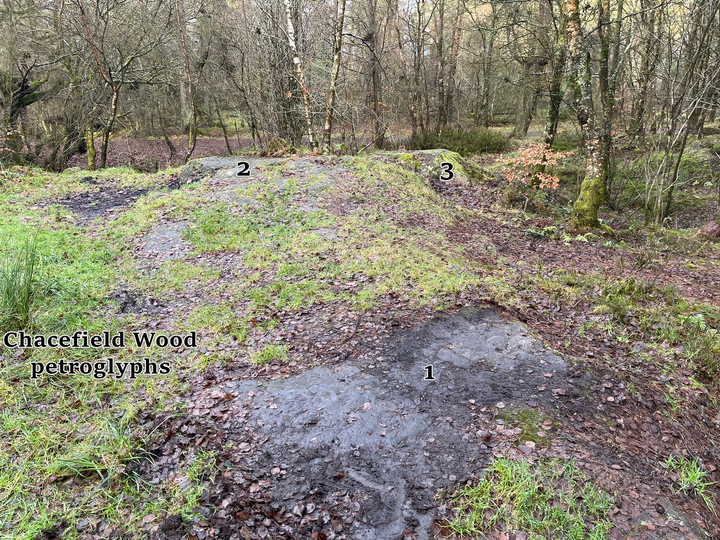
We took the A872 road on the south-side of Denny to Dennyloadhead and Longcroft, but a few hundred yards before you go under the M876, keep your eyes peeled for Drove Loan on your left. Go down here for literally ¼-mile (0.4km) where there’s a footpath into the woods on your left. Walk on the path into the trees and you’ll reach a track that heads to your right (east). Less than 200 yards on, you’ll see a pond on your right and above here is a small quarried rock outcrop. This carving’s up top, on the gently sloping rock behind carvings no.2 and no.3.
Archaeology & History
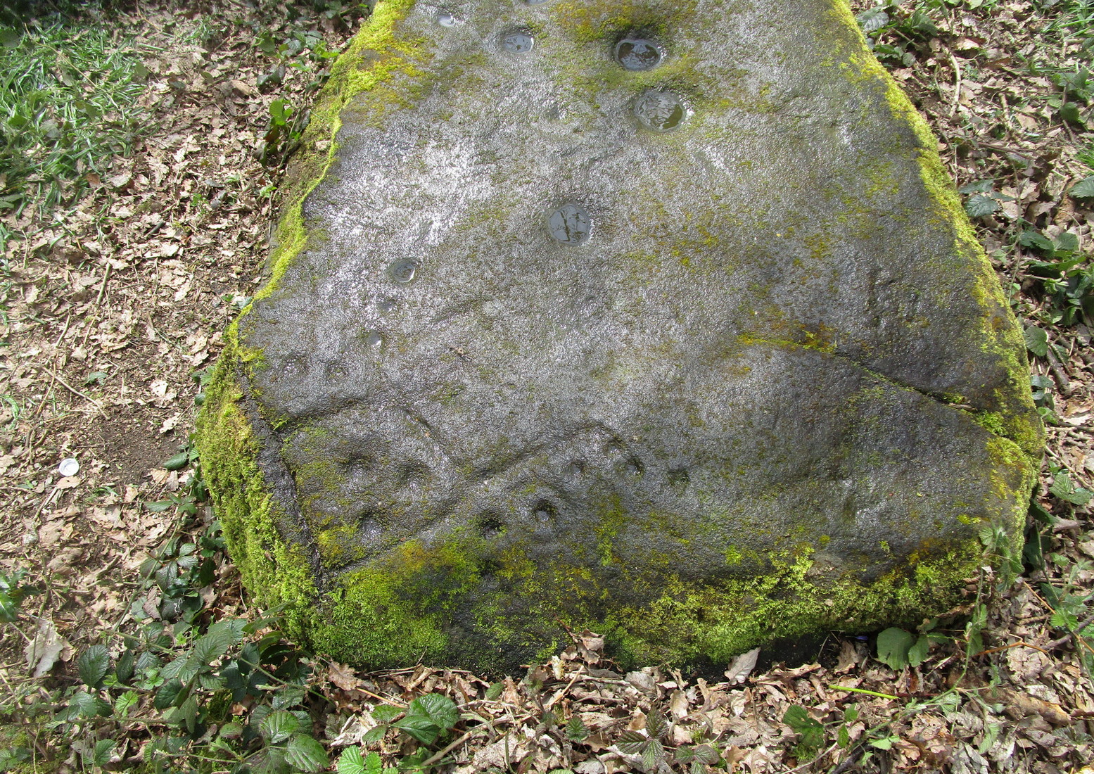
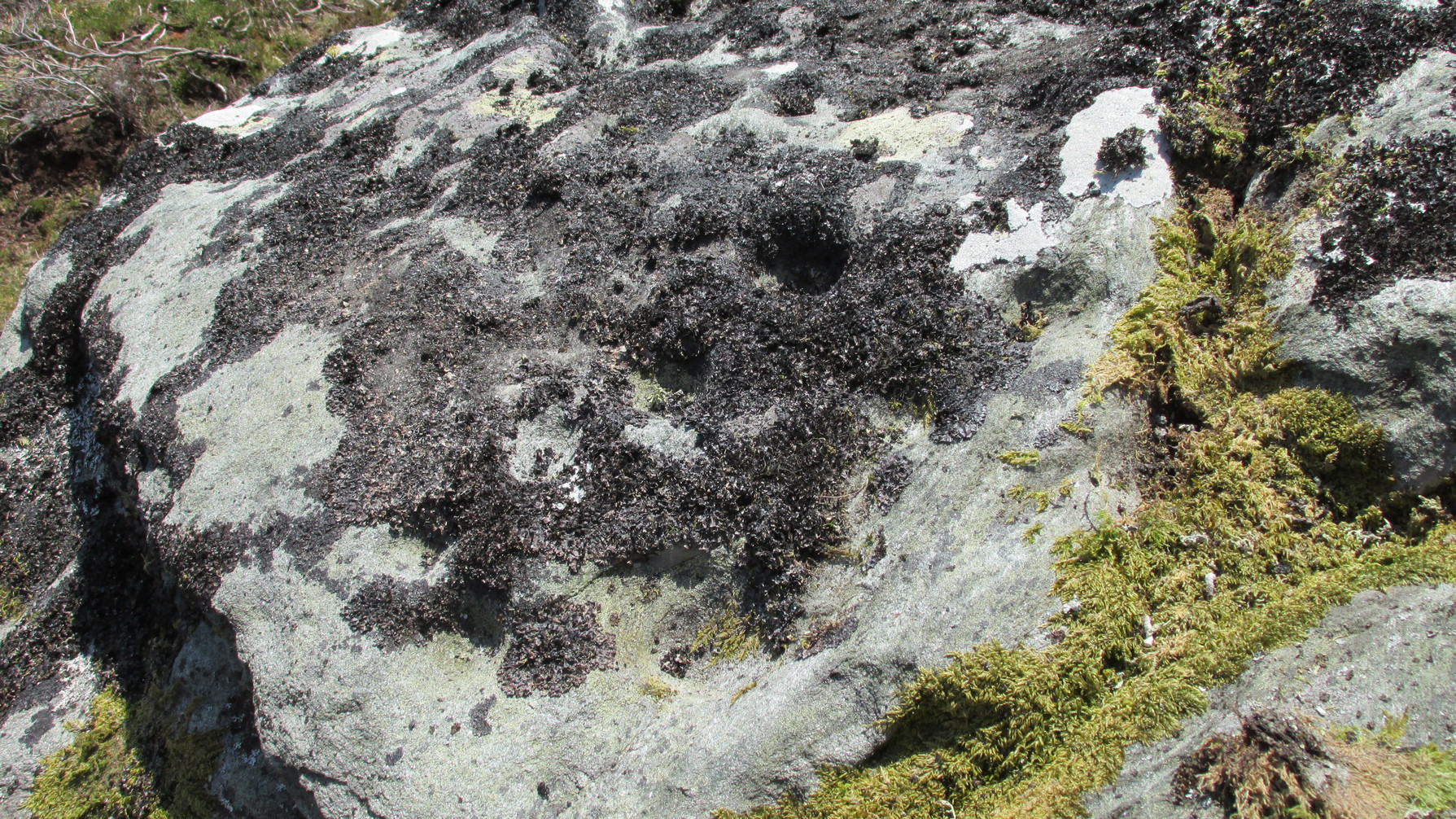
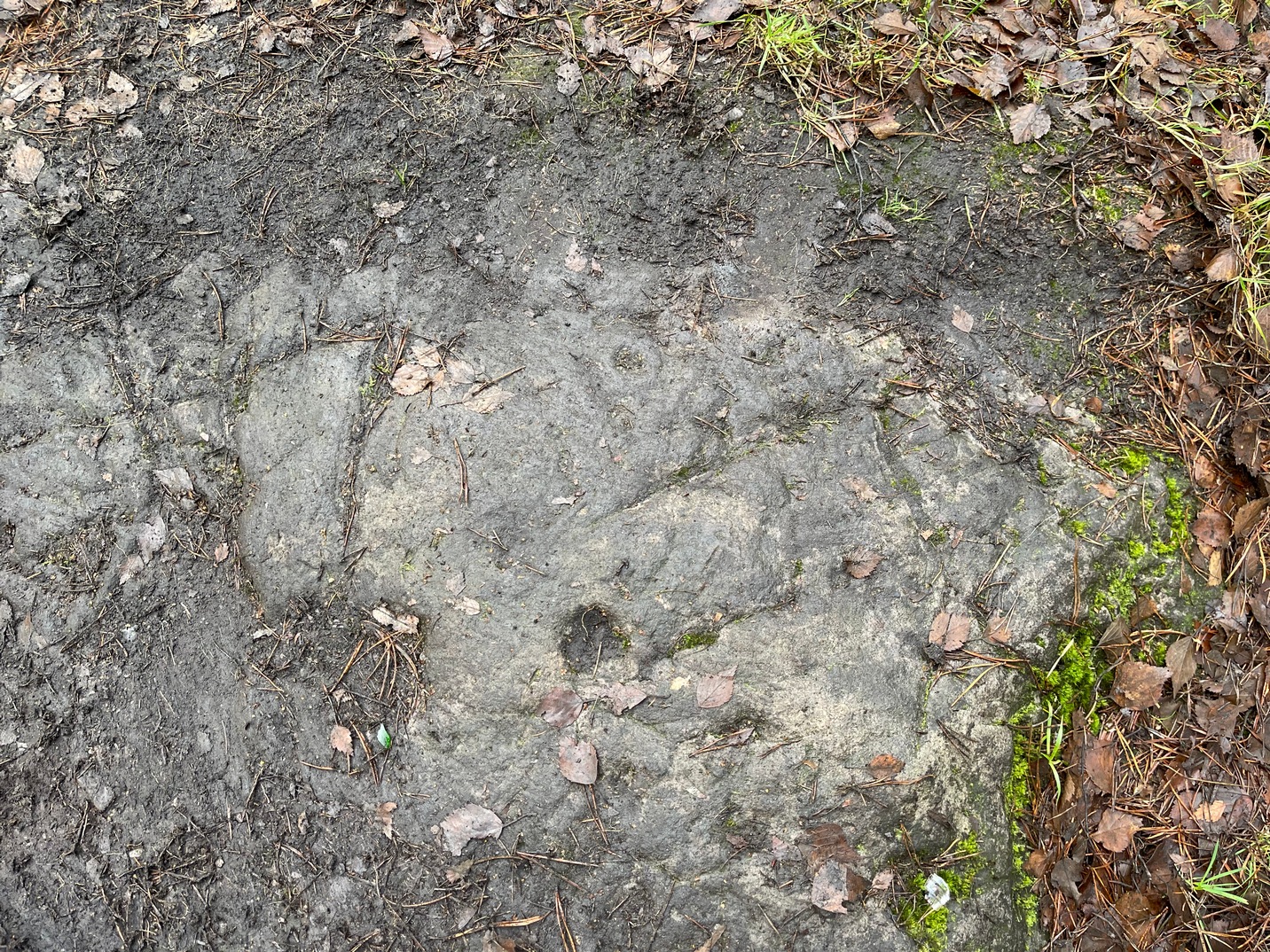
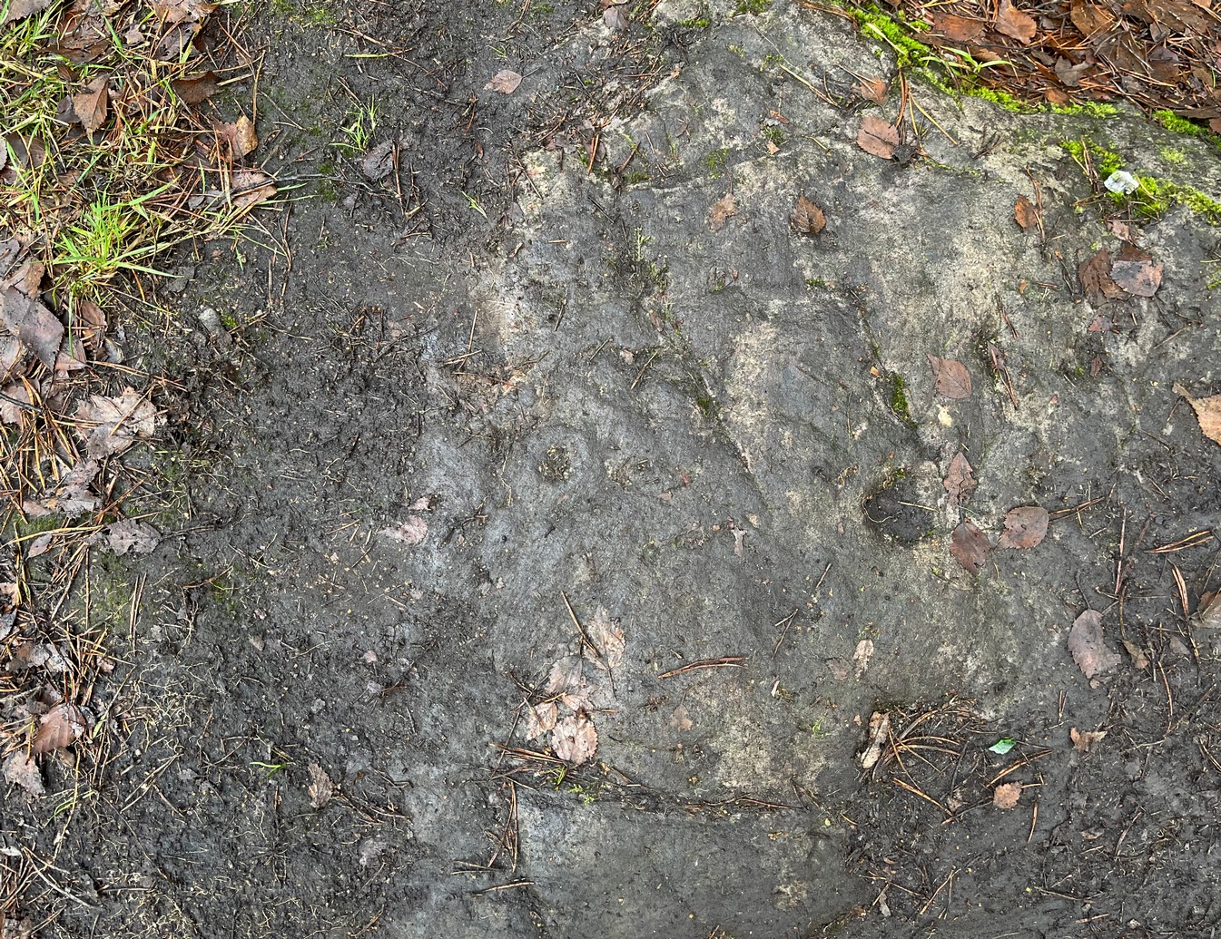
Half-covered in mud and vegetation, the first thing you’ll notice on this sloping smooth surface is what looks to be a standard cup-marking, all on its own. But it has company—albeit quiet and faint. A single incomplete cup-and-ring can be seen about 18 inch above (north-ish) this single cup-mark, which may itself be natural. You can make out the cup-and-ring pretty clearly in the photos.
When we found this, we began to clear the rest of the stone but stopped pretty quickly as a scatter of broken glass was mixed into the mud and I was lucky not to cut my hand open. Some kids have evidently been getting pissed here and have left their mess on the rock. But there may well be more symbols beneath the mulch, so if any local folk want to clean it, please make sure to wear some good gardening gloves to protect your hands! And if you find any other hidden elements, please let us know!
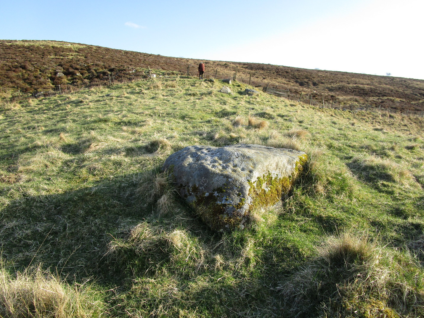
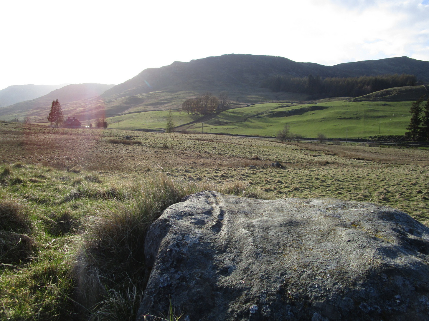
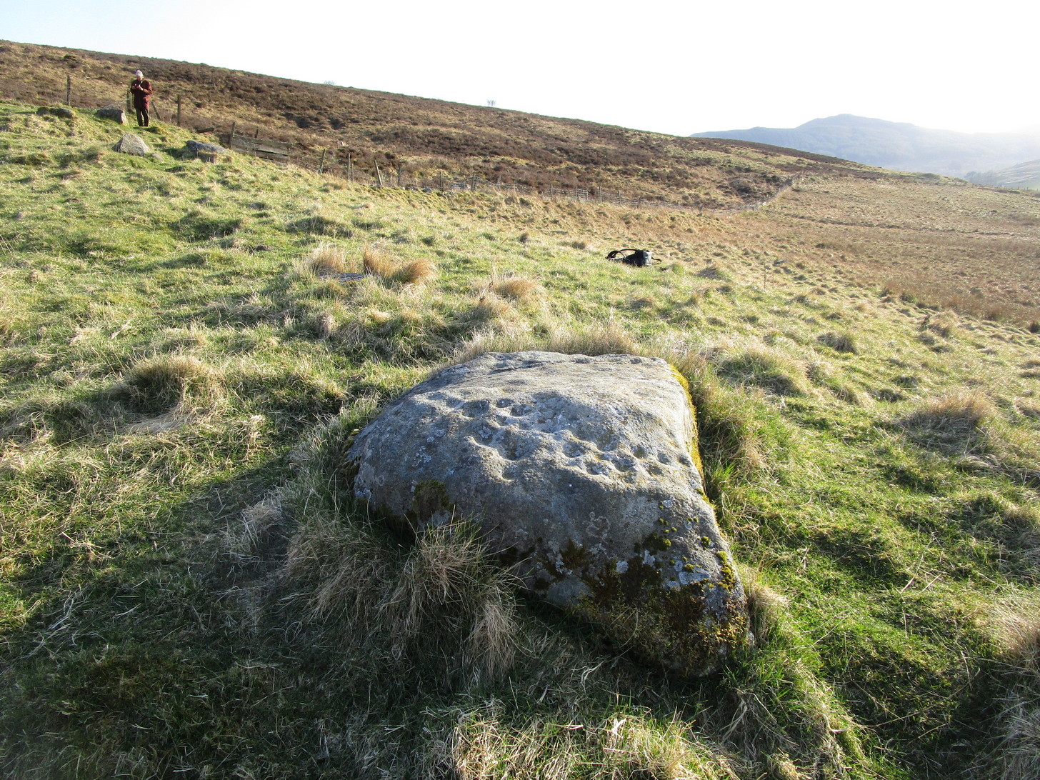
The quickest and easiest route is to take the A924 road from Pitlochry to Kirkmichael. It’s a gorgeous route in itself! Anyhoo… Once you’re out past the houses of Pitlochry and Moulin, you begin to make the real ascent up the winding road, past the hairpin bend and, 5 miles up where the road has levelled out and the craggy moorlands surround you, green fields begin to appear on your left. The first farm on your left is Dalnacarn and less than a half-mile past here, on your right, a small track takes you to Dalnavaid house. Walk along here, past the house and into the field, then the next field where a section rises up towards the fencing. On top of this are several rocks. You can’t really miss it!
Archaeology & History
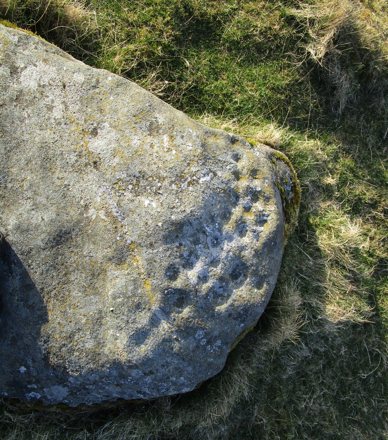
This typically female rounded rock has, unusually, a series of cups in almost three rows along its easternmost slope, with one or two single cups on its top and southern side. It was first described by Fred Cole (1908) merely as “a small boulder, with a remarkable triple row of cup-marks, resting on a cairn-like mound”; but it wasn’t until John Dixon (1921) came here that a full description appeared. He told us,
Primary rows of cupsLong worked (?) line
“About 200 yards due east of (Dalnavaid) house a ridge or spit of land juts out from the adjoining hillside on to an almost level field. The ridge has sloping sides, and the nearly flat top is 10 or 12 feet above the general surface of the field. Near the end of the ridge stands the cup-marked stone… The dimensions of the stone are: length 4 feet 8 inches; width 3 feet; height from 1 foot 11 inches to 2 feet 4 inches. The cups are all near the north-east side of the upper surface of the stone, and are more or less in rows. Some are large, with a diameter of 3 inches and a depth of nearly 1 inch; others are much weathered, and vary from small, scarcely measurable, hollows, to cups 2 inches in diameter and ½ inch deep. The hollows are no doubt cups almost obliterated by ages of weathering. Reckoning them so, there are in all thirty or thirty-one cups. All are of the plain type, without rings or connecting grooves.”
Looking (roughly) west
A few years later Mitchell (1923) counted 26 cups on it. Along the western side of the stone are two natural cracks that run across it roughly north-south. It wasn’t until I crouched down to look at what seemed to be another cup on its vertical face that I noticed how these lines appeared to have been enhanced by human hands.
For petroglyph enthusiasts, this is a decent carving well worth the visit. What looks to be a cup-and-ring design is found on a stone due south of here and, in all probability, others are hiding away nearby—the “lost” cup-marked stone of the Clunskea Burn, a mile north of here, being one such place. Let us know if y’ find it!
Of the “two stones bearing possible cup markings” mentioned in the Royal Commission (1978) survey of the area, this is one them – and it’s a dead cert, not a mere “possible.” It was rediscovered by Tom Welsh (1976) when he explored the large low-walled enclosure on this plateau. The carving is on a small rounded stone near the southern perimeter of the enclosure. Welsh described it as, “a boulder 48 x 35 x20cm, bearing six cups 45mm diameter, arranged five round a sixth, the pattern being 15cm across.”
A second cup-marked stone was also located “2.5m in from the last perimeter” bearing a single well-defined cup-mark more than an inch across. This seems to have been lost.
References:
Royal Commission Ancient Historical Monuments, Scotland, The Archaeological Sites and Monuments of Dumbarton District…, HMSO: Edinburgh 1978
Welsh, T.C., “Lang Craigs, Milton, Enclosure, Cup marks, Foundation, Mound, Platform”, in Discovery & Excavation Scotland, 1976.
Cup-and-Ring Stone (lost): OS Grid Reference – NN 880 252
Archaeology & History
A long lost carving, probably quite impressive in design, was recorded by John Laurie, schoolmaster in Monzie. He told us that,
“a large Druid stone with rude carving upon it lies on the side of the public road between the villages of Monzie and Keppoch. This stone was one of a Circle which Mr Monroe, the then minister, caused to be broken and dispersed.”
When Fred Coles looked for the remains of this “circle” at the beginning of the 20th century, he questioned Laurie’s location of the site, but found remains of one in an adjacent field consisting of two stones, but told that “on neither of them could we discern any carving of any sort.” It’s likely that the carving has been completely destroyed, or if we’re lucky it may be hiding in some nearby walling.
Tumuli (destroyed): OS Grid Reference – NU 273 046
Archaeology & History
In a lengthy letter describing the cist burial at Cliff House, its author, Mr W. Dunn (1857) told that there were additional prehistoric remains nearby, that had only recently been destroyed. He told:
“It appears that, a few years ago, in the immediate proximity of the present discovery (at Cliff House, Ed.) two or more tumuli were found which contained urns and bones; and flint arrow heads of elaborate finish have been occasionally met with.”
I can find no additional information about these sites.
In the same article, a Mr Kell told that during the construction of the Amble piers a half-mile to the west, “some years ago, he was sojourning in the neighbourhood, and …human remains were found on the removal of sand by the waves in a violent gale from the East.” What else is known of this place?
References:
Dunn, W., “Ancient Sepulchral Remains,” in Proceedings Society of Antiquaries Newcastle-upon-Tyne, volume 1, no.34, 1857.
Cist (destroyed): OS Grid Reference – NU 2730 0486
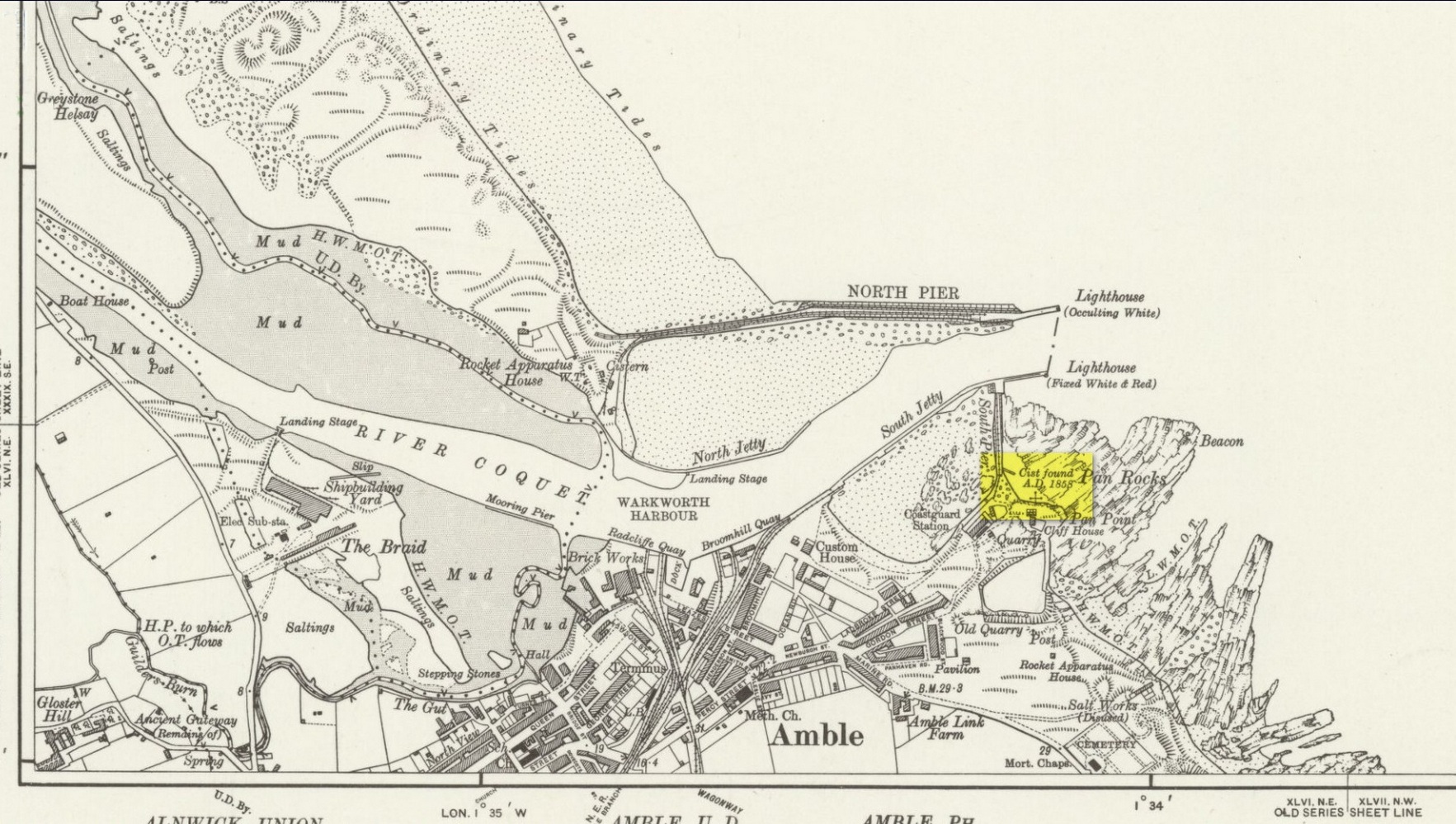
Archaeology & History
Site location on 1926 map
In November 1857, Collingwood Bruce read out a paper that had been sent to him by the Rector of Warkworth village (Rev. W. Dunn), describing “ancient sepulchral remains” that had been found near the cliff-edge above Pan Rocks near Amble’s lighthouse. It was a lengthy account which, in passing, also mentioned several other prehistoric sites close by that have long since been destroyed and which we have very little information about. Mr Dunn’s (1857) letter told:
“In the middle of April last, about 50 yards NE of the Cliff House, Amble, and about 20 yards from the end of what is called Warkworth South Pier, the pilots came upon a long upright stone, standing out of the shale to the height of twelve or fourteen inches,which had been laid bare by the recent heavy gales, but which, from its rude appearance, did not afford the idea of anything beyond a mere accidental tilting. Alongside this upright stone was a large unwrought slab, which, on being raised, was found to be the covering of a cist or sepulchral chamber containing a perfect skeleton. The figure was lying on its left side, with the head to the south-west, having the knees much doubled and with the right arm thrown back. By its side stood an urn of unbaked clay. This urn, now in the Museum of the Duke of Northumberland, resembles in size and shape that which was found a few years since at Hawkhill, and which is preserved in the Museum of the Antiquarian Society of Newcastle. It contained a small quantity of dark earth.
“Having given this general outline of the discovery, I shall proceed to offer such observations as I have been able to make,and have considered worth recording. I grieve to say that before the period of my visit the spoiler had been busy with these venerable remains. The skull had been broken up, the jaws smashed, every tooth appropriated, and the bones indiscriminately mingled, after many a century of undisturbed repose.
“The cist or chamber containing the remains was composed of four slabs inserted edge-wise in a cavity which appeared to have been dug out of the friable shale which lies upon the harder rock in this locality. It ranged south-east and north-west, and measured as follows: depth, 18½ inches; width, 26 inches; length at bottom, 4 feet; at top, 3 ft 4 in.; the difference between top and bottom measurements being accounted for by the shrinking of the ends. The cavity in the shale was much larger than the cist, and the space between the slabs and the shale was closely filled-in with stones, roughly broken, commingled with earth and larger stones. The side slabs projected somewhat beyond the ends. The bottom of the cist was covered to the depth of about half an inch, with dark, unctuous mould. Amongst the rubbish comprising the filling-up of the space above-mentioned, was found an angular piece of silex, probably an unfinished arrowhead; and in the south-west corner of the cist lay a large, smooth cobble stone, which, when considered in conjunction with the flint flake, the imagination may easily construe into the club of this ancient denizen of our shores. The slab which constituted the cover of the cist was of great size and extended in every direction considerably beyond it; and the upright stone was set up, not at one of the ends, but along its length. It is remarkable that a close inspection of these stones gave no trace of chisel-marks in any part. In order that the cover might lie level, pieces of shale, flags, etc., were laid on the uprights which formed the cist, wherever an irregularity presented itself.
“Within the memory of man, the rock ran out from this point for some yards into the sea at a considerable elevation; but the construction of a pier in the immediate neighbourhood has caused the removal of much of the stone, and the spray of our wild sea waves now dashes over the spot which for countless generations may have been peacefully tenanted by these nameless bones. At the same time, it does not appear probable that at any period there has been at this particular point a very deep covering of the sand and bent-grass which are found thick and rank upon the adjacent links.
“The skull must have been very characteristic, having attracted general observation from the extraordinary lowness of the frontal region, the great development of the occipital portion of the head, and the width and length of the lower jaw from its anterior junction to the articulation of the temporal bone. One person observed that during life the man “must have measured as much to the top of his eyebrows as to the top of his head.” The teeth are said to have been very beautiful and regular, and quite sound. With the exception of a front tooth, which was missing in the lower jaw, they were perfect. The thigh-bone measured 19½ inches, indicating a man of large size; whilst the porous internal organization of the bones gave probable evidence of comparative youth.
“The urn is unbaked, of a light clay colour, and measures in height 8 inches, in depth 7¼ inches, and in diameter 5½ inches. It is ornamented with zigzag scoring, alternating with dotted lines,and upright (and sometimes slanting) scorings, which appear to have been made with some rude instrument whilst the clay was moist. The scorings are continued over the edge of the rim. On being rather roughly seized by one of the men, it being expected that it contained treasure, a piece was broken off; but no material injury has been occasioned. The stone found in the cist does not resemble any that one may pick up on the neighbouring shore, and attracted attention from its bearing no assignable relation to what I may call the masonry of the tomb. I have since learnt that stones are not infrequently found in Teutonic graves on the Continent, and that recently a singular oval stone was found in a tumulus on Petersfield Heath.”
All trace of this site has disappeared. Mr Bruce posited the idea that the round stone in the cist may have been the one that ended the life of the buried man! An intriguing thought. And that the urn “no doubt, contained some portion of the feast prepared on the occasion of his funeral.”
References:
Dunn, W., “Ancient Sepulchral Remains,” in Proceedings Society of Antiquaries Newcastle-upon-Tyne, volume 1, no.34, 1857.
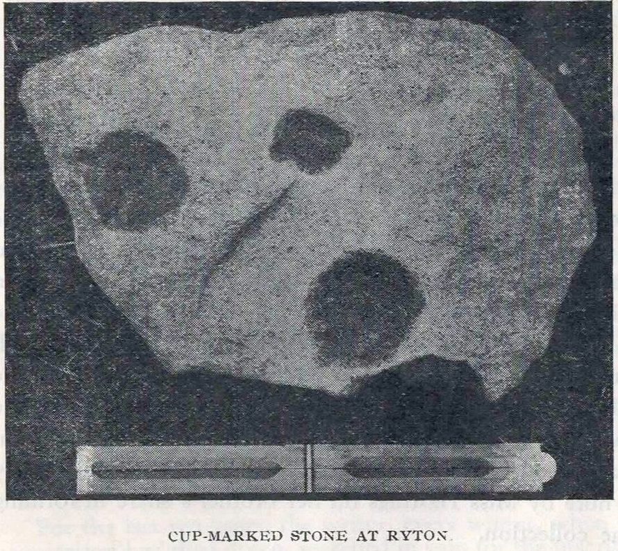
Cup-Marked Stone (removed): OS Grid Reference – NZ 1480 6417
Archaeology & History
Ryton cup-marked stone
In a short piece read before Newcastle’s Society of Antiquaries in 1942, a Mr Cocks (don’t laugh!) told that when a friend of his was clearing out an old land drain in his garden, he found this fragmented cup-marked stone, “which had been made use of as a corner slab on the drain”! It was located “about 40 yards south-west of Tweedy’s Buildings,” on the west side of town. Broken from a larger piece of stone, the attached photo here shows the simple design of the basic cup-marks, measuring respectively 2½, 2 and 1⅝ inches across. Mr Cocks told that “there are also two finger-tip hollows on the stone tone which or may not be natural. A dark line running between the cups is a natural fissure.”
Last we heard, the stone was living in a box somewhere in the archives at the Great North Museum, Newcastle.
References:
Cocks, W.A., “A Cup-Marked Stone at Ryton,” in Proceedings Society of Antiquaries Newcastle-upon-Tyne, volume X, no.2, January 1943.
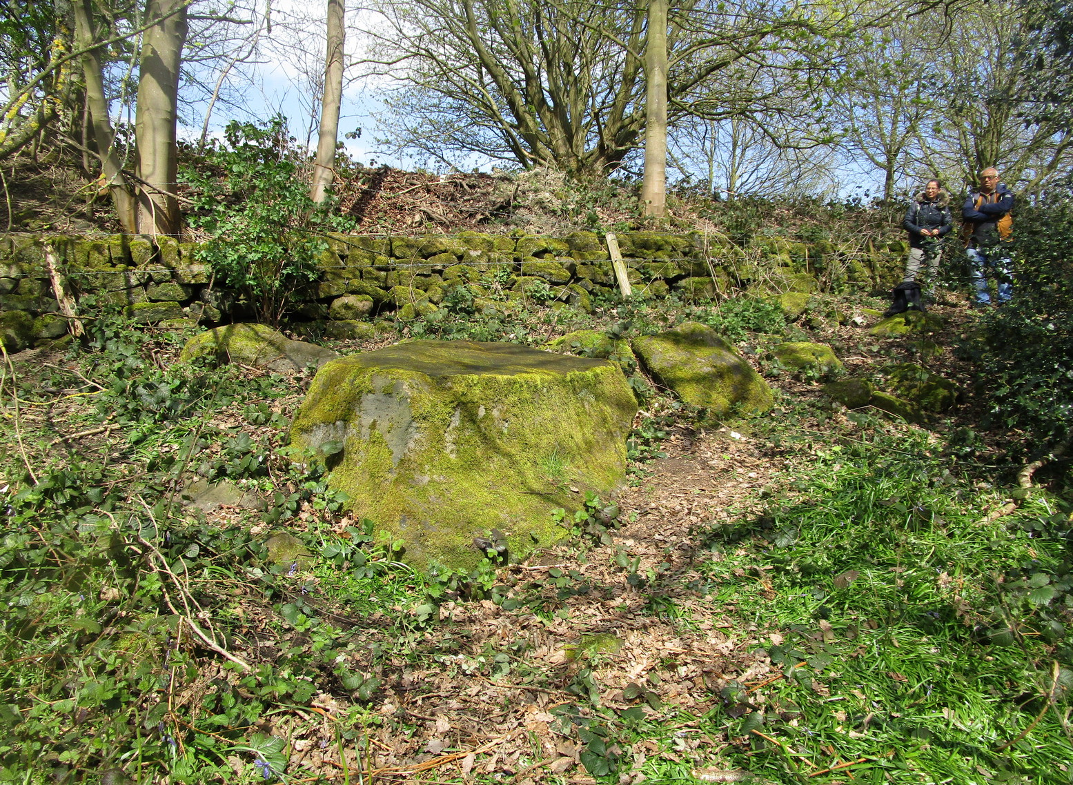
On the north side of Cookridge, find Smithy Lane and go to the western-end, where it meets up with a dirt-track. Walk straight along here by the side of the cricket-pitch and then take the first turn left where you walk along the other edge of the cricket pitch. About 150 yards along, the track hits the woods; keep along here for about another 200 yards where you’ll find a small footpath on your left goes into the woods. Once you’re in in the trees, walk to your right, following the wall, for about 50 yards where you’ll see a large flat stone by the holly trees. That’s it!
Archaeology & History
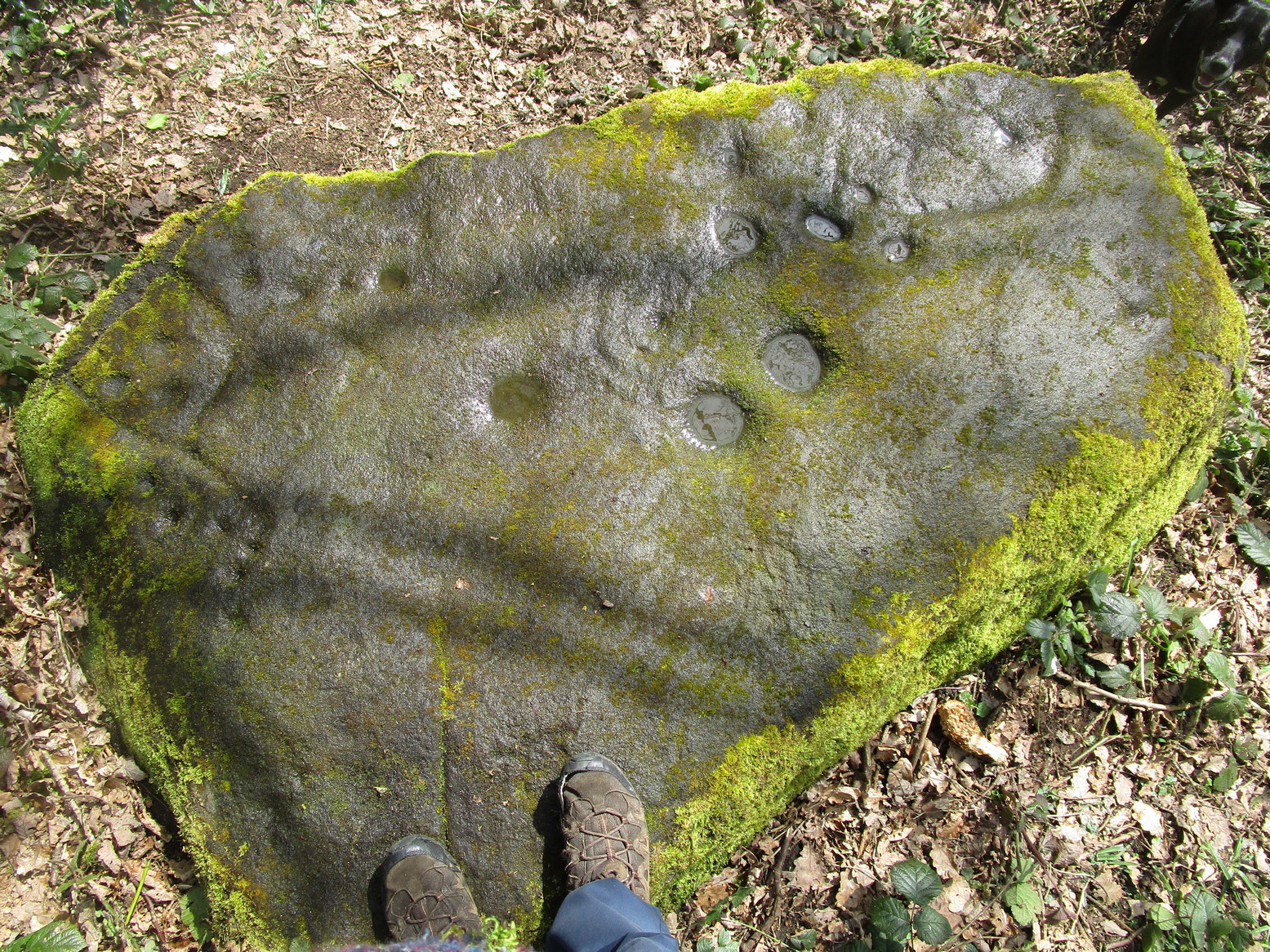
Rediscovered by the Leeds historian Don Cole in the 1940s, this complex multi-period carving etched onto a flattened rock surface is an unusual outlier from the Rombalds Moor complex several miles to the west. At its heart, around the semi-natural deep “cups” near the middle of the southern side of the stone, is the oldest part of the carving comprising a very faint incomplete triple-ring design which, as we move around it, almost has the look of a Newgrange-lozenge form to it. But I’m unsure…
Very faint incomplete triple-ring at top-middleWaves & cups and rings
More obvious (apart from the deep “cups”), and the first thing you notice as you approach the stone, are the later and much more well-defined elements on the east side of the stone: a curious wave-form writhes from the edge of the rock across its smooth surface, beneath which we find a cup-and-ring and a number of single cup-marks, some enclosed inside a rounded box, with others sat between the curved carved line and the stone’s edge. The “rounded box” with its three cups at first seems to be on its own, but as the light changes you’ll notice a much fainter (possibly older) rectangular box attached to it; no cups are visible inside this.
A hundred yards due south in the same woodland you’ll find the Gab Woods (2) carving.
One interesting feature is the name of the woodland in which the stone resides. In Thomas Wright’s massive dialect work, Gab is a northern dialect word meaning “to talk”, or “idle chatter” (and variants thereof); this is echoed in Blakeborough’s (1911) Yorkshire survey; and Wilkinson’s (1924) local study tells simply it to be “idle talk…able to talk glibly and with much plausibility—a Town Hall Square orator for instance.” This makes the place as something akin to being “the woodland that talks”, “the chattering woods” or “the talking woodland”, etc. You can make up your own mind as to what this might mean… *
References:
Blakeborough, Richard, Wit, Character, Folklore and Customs of the North Riding of Yorkshire, W. Rapp: Saltburn 1911.
Wright, Joseph, English Dialect Dictionary – volume 2, Henry Frowde: London 1900.
Acknowledgements: Huge thanks must go to Peter Murphy for recovering this impressive carving from beneath the carpet of soil and vegetation, and so enabling it to be seen by others once more. Also big thanks to the usual culprit of James Elkington, as well as Sarah Walker and Sarah Jackson.
* a Scottish dialect variant of gab relates to the mouth, tongue, taste.
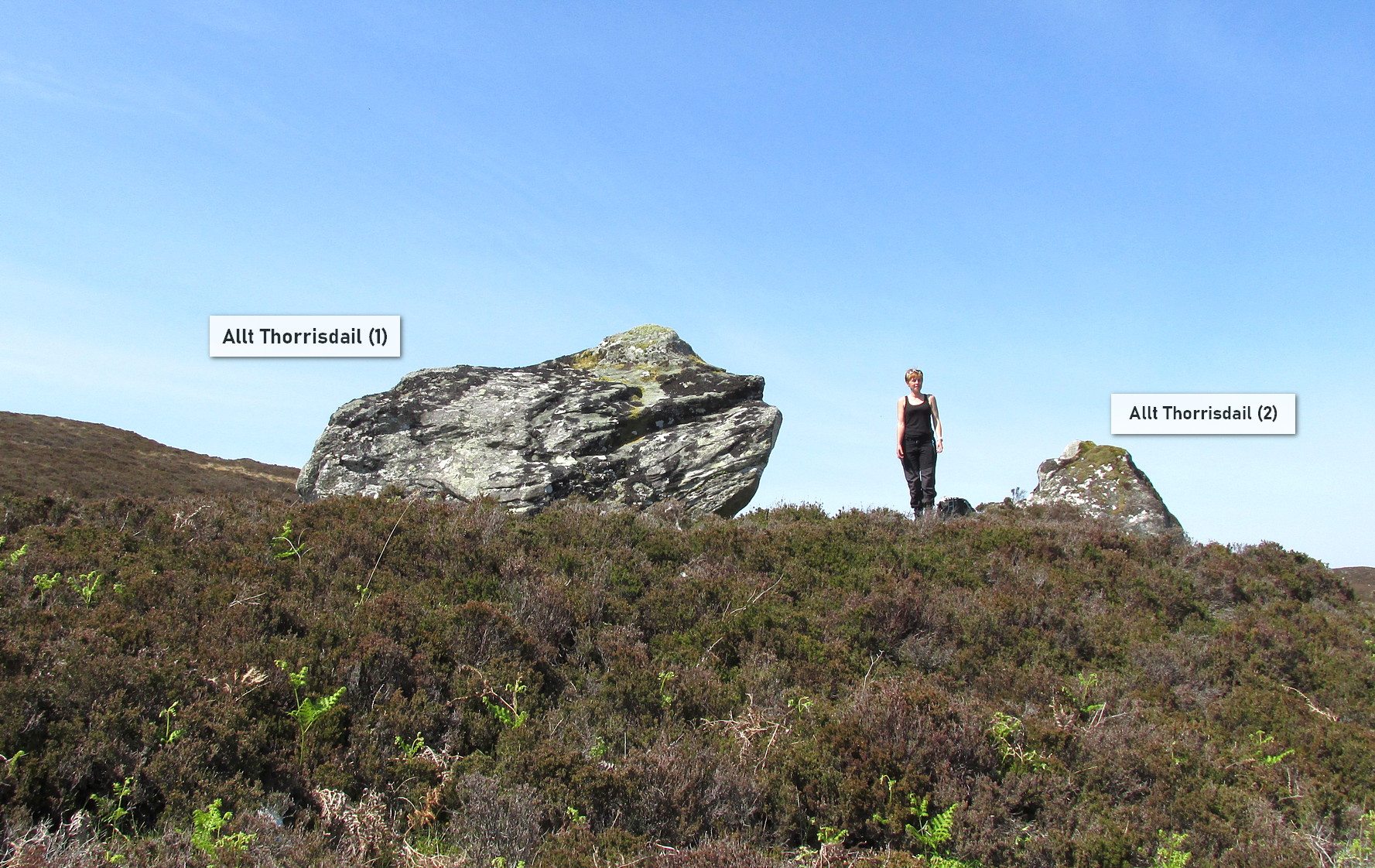
Roughly halfway between Bettyhill and Tongue on the A836 road, keep your eyes peeled for the sign to Skerray (4 miles) and travel down that road. About 1¾ mile on, take the tiny lane on your left up the slope for 0.6 miles (1km), and just before the sharp bend in the road (across a small bridge) there’s a gate on your left. Go thru here and follow the tiny path alongside the burn (stream) westwards for half-a-mile until where the waters become a bog within a wide oval bowl in the landscape. At the far-side you’ll see two large boulders sat above this watery bowl. That’s where you need to be!
Archaeology & History
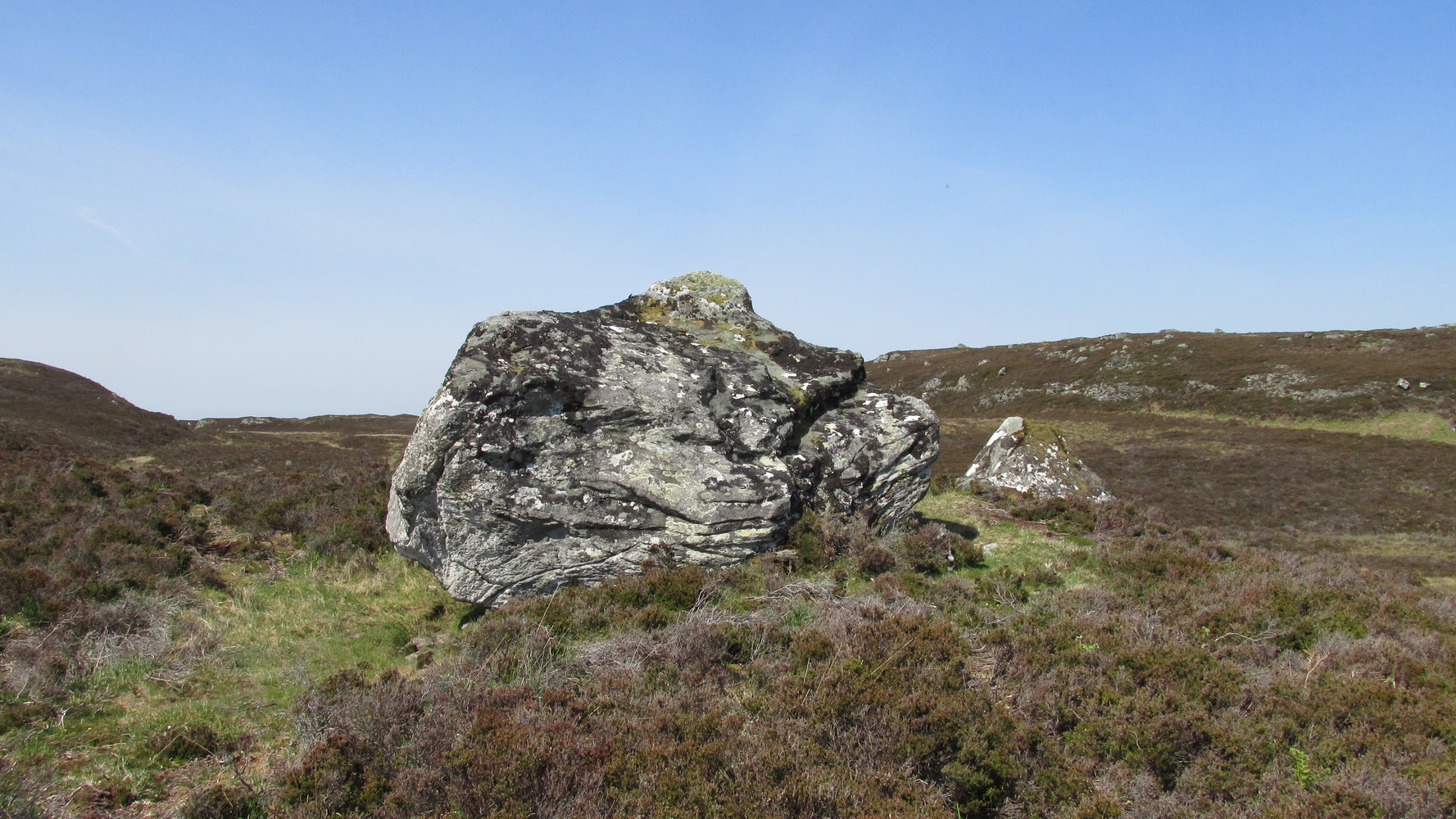
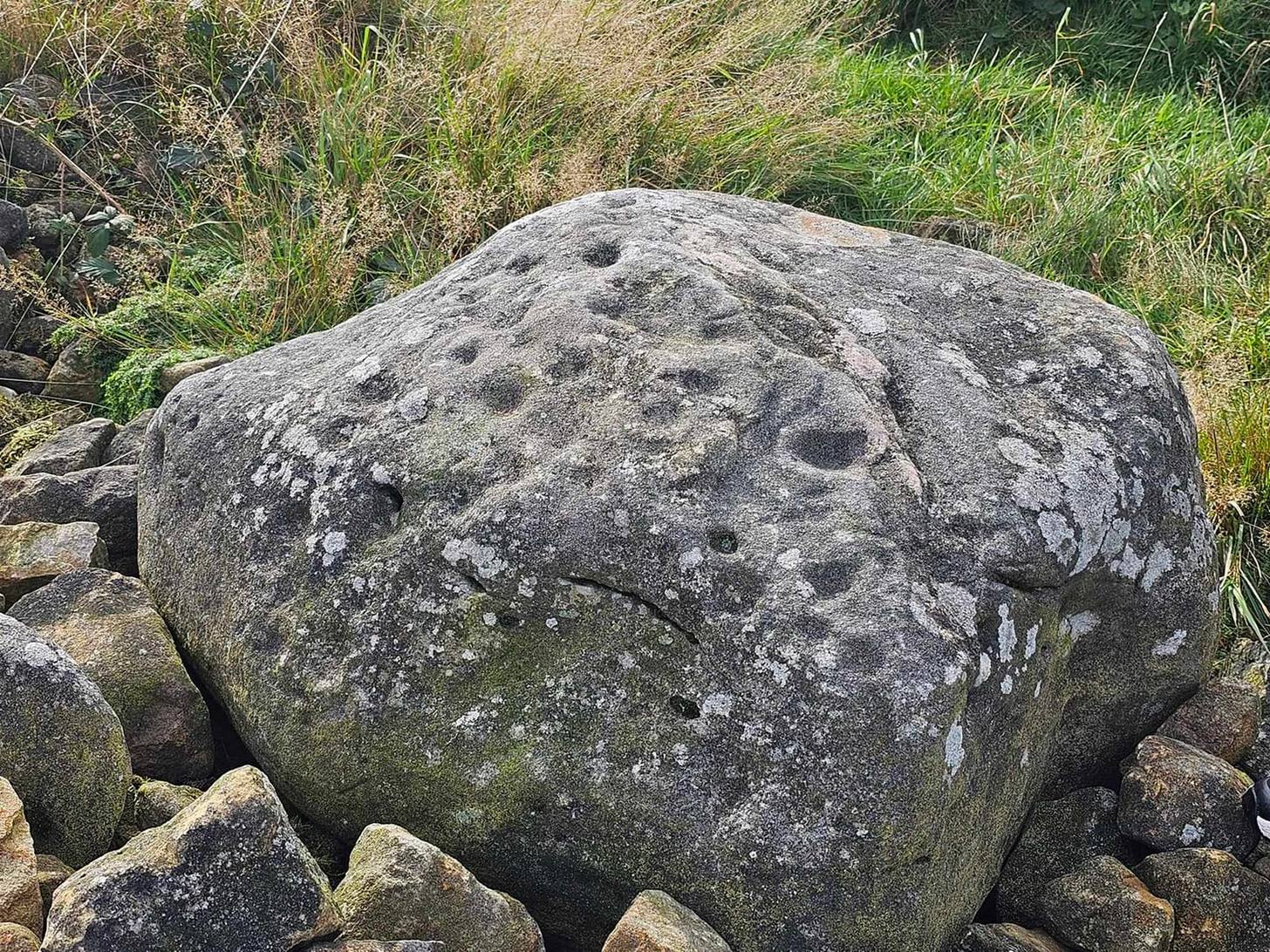
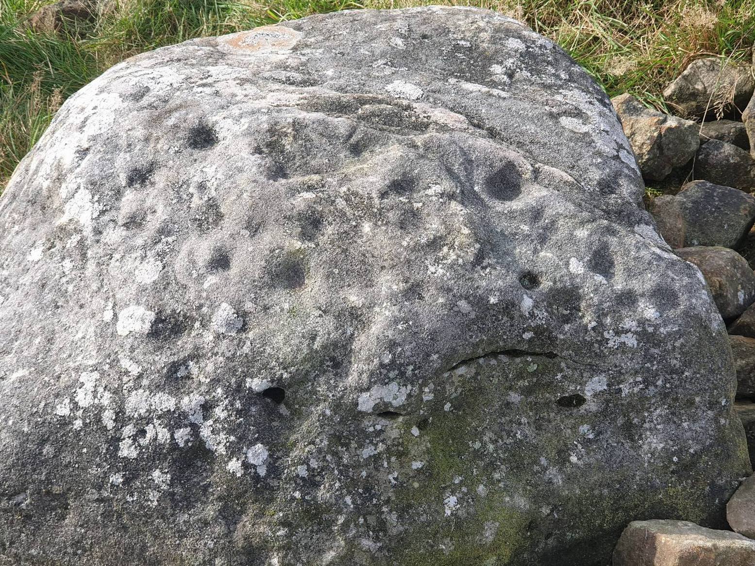
The big fella of the two
This is carving “number one” of two great incised boulders that are sat upon a natural ridge overlooking a dried-up lochan. An impressive spot that give a thoroughly distinct impression of altar stones above the sunken waters, from whence rites and proclamations were performed. It has that look and feel about it—and any animist would tell you the same. My hardcore dreams aside though…
This profile is for the larger of the two boulders that live here (Allt Thorrisdail 2 is here). It has very curious petroglyphic attributes—much like its compatriot—unlike many of those in these northern lands. The pair of them seem to have been described for the first time in Hew Morrison’s (1883) fine meanderings through the mythic history of the region. He told that,
“About a mile distant (from Torrisdale) two large cup marked boulders lie on the slope of a hill. The marks are disposed in groups of one large and nine smaller cups. On the larger boulder there are two of these groups and seven separate marks.”
There are slightly more than that, and this was pointed out when the Royal Commission (1911) lads came to see it:
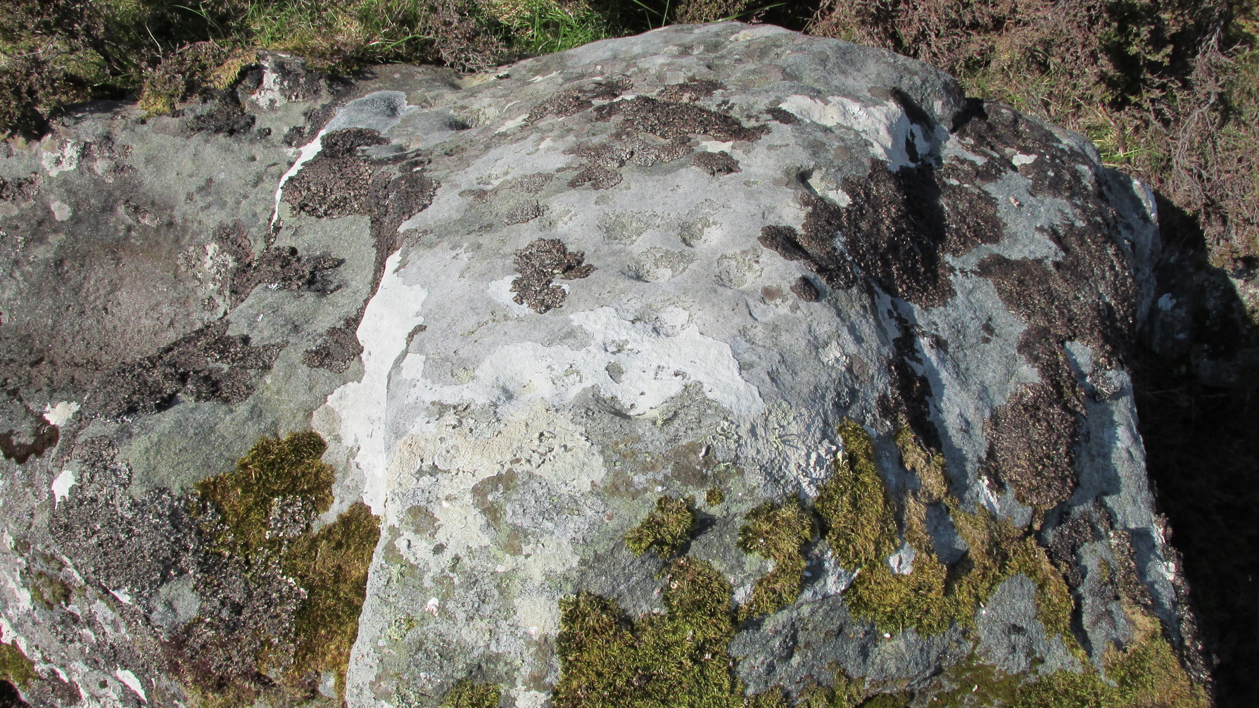
“The largest boulder, that situated furthest west, is about 8 feet high and 14 feet in length. On its south side, chiefly on the flat and less abrupt face of the stone, are groups of cup-marks of from 2in to 3in in diameter, the deepest being about 1in in depth, while a number are now almost obliterated. The extent of the markings is not very definite, but there appear to be two groups containing about twelve cup-marks each.”
Another chorus of cupsLichen-dappled cupmarks
But this only tells of half the stone’s symbolic story. For on the vertical northern face of the rock, from just above ground-level, we have a distinct almost straight line of many cup-marks, going up diagonally, at an angle of about 35º. I took a number of photos of this aspect of the stone, but the covering of lichens didn’t highlight them clearly at all. When you’re stood looking at them they stand out like a sore thumb!
I have to be honest and say that I bloody well love this site! You have to paint the entire environment in the right light, as it was when the stone was first carved, surrounded by the scattered woodland of birch, pines and rowan all across where now we have stunning barren moorlands. Tis a ritual place indeed – without any shadow of doubt!
References:
Mercer, R.J., Archaeological Field Survey in Northern Scotland 1976-1979, University of Edinburgh 1980.
Royal Commission on Ancient & Historical Monuments, Scotland, Second Report and Inventory of Monuments and Constructions in the County of Sutherland. HMSO: Edinburgh 1911.
Acknowledgements: Huge thanks to Sarah MacLean for her company and landscape knowledge in visiting this and other nearby antiquarian remains. And to Aisha Domleo, for getting me into this neck o’ the woods.
From Holymoorside, take the long straight Loads Road running west out of the town into Longside Road. ¾-mile along, past Home View and just before Well Lane (on the right), there’s a public footpath sign pointing into the fields on your left. Walk dead straight, dead south along the wallside for 450 yards, then walk straight left again along the other wall until you reach the tiny bit of moorland less than 150 yards away. The carved rock is just on the other side of the stile at the edge of the old walling. You’ll find it.
Archaeology & History
Rediscovered sometime in 2002, this would seem to be an isolated cup-and-ring stone. It was first mentioned in John Barnatt’s (2003) short gazetteer of Peakland petroglyphs, where he wrote,
“This irregularly-shaped small boulder was identified recently lying amongst post-medieval field clearance adjacent to a field corner and footpath… Its upper parts ar covered with 40-46 cupmarks. On the exposed irregular top they are badly worn and sometimes uncertainly identified. In one instance a cup is partly encircled by a worn ring, while a second partial ring nearby may be fortuituous. On a ledge near one edge of the boulder preservation is better and the cups are clearly defined and densely arranged.”
The stone looks as if it’s been moved into its present location, obviously for use in the walling. It’s original position would have been somewhere close by, but we know not where that might be.
References:
Barnatt, John & Robinson, F., “Prehistoric Rock Art in Ashover School and Further New Discoveries Elsewhere in the Peak District,” in Derbyshire Archaeological Journal, 123, 2003.
 When we found this, we began to clear the rest of the stone but stopped pretty quickly as a scatter of broken glass was mixed into the mud and I was lucky not to cut my hand open. Some kids have evidently been getting pissed here and have left their mess on the rock. But there may well be more symbols beneath the mulch, so if any local folk want to clean it, please make sure to wear some good gardening gloves to protect your hands! And if you find any other hidden elements, please let us know!