Cup-and-Ring Stone (removed): OS Grid Reference – NO 378 308
Archaeology & History
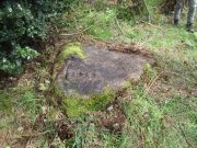
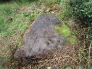
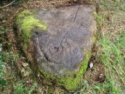
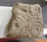
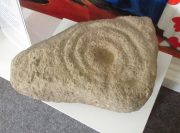
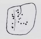
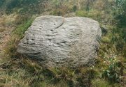
This little-known cup-and ring stone was found at ground level sometime around 2003, near the top of Balgay Hill. A small portable stone that may have been broken from a larger slab, it has what seems to be two if not three cup-and-rings, accompanied by two or three single cup-marks. One of the rings seems to have a faint line coming out of it. Unfortunately none of this is clear in the photos I took (the one attached here is the best), as it lives under glass in Dundee Museum, so it was very difficult to get decent images. It is now housed in the McManus Museum in Dundee (a damn good place, with very helpful staff) and well worth checking out if you’re in the area.
Cup-and-Ring Stone (removed): OS Grid Reference – NO 5061 5565
Archaeology & History
Close to the western walls of the Finavon Iron Age hillfort this small (portable?) cup-and-ring stone was found at ground level in 1987. It was probably knowingly reused in the construction of the hillfort, but whether it was just deemed as an innocuous carving thrown into the mass, or whether it held a place of importance cannot be known.
The primary design consists of a cupmark surrounded by a double-ring, with a line coming out of the central cup towards the edge of the stone. The stone itself—measuring 12 inch by around 10 inch—has been cut from a larger piece, meaning the original design may have been larger. It is now housed in the McManus Museum in Dundee (a damn good place, with very helpful staff).
Cup-Marked Stone (lost): OS Grid Reference – NO 3975 3340
Also Known as:
Magdalen’s Kirkton Stone
Archaeology & History
In the mid-1890s, workmen ploughing one of the fields near the steading at Magdalen’s Kirkton farm hit a large stone beneath the soil. It turned out to be the covering stone of a prehistoric burial, or cist, that was aligned east-west. Whilst the remains in the cist had all but turned to dust, the covering stone had a number of cupmarks on it. It was described only briefly by R.N. Kerr (1896), who told that,
“The stone forming the lid of the cist is cup-marked. It weighs 5 cwt., 1 qr., 21½ lbs., and its thickness varies from 9 to 12 inches. There are 40 or more cup-markings on it, varying from 1 to 3 inches in diameter.”
It would seem that no sketches were made of this carving and I’ve been unable to find any more details about it. Help!
From Doune, take the A84 road to Callander. As you pass through the hamlet of Buchany, keep your eyes peeled a few hundred yards on as the road dips down and swerves gently right, for the road sign of Drumloist (or Moist as some locals keep amending!) which goes up to the right. It’s a small single track road that zigs and zags slowly uphill. After exact one mile you reach a small track on your right (there one left too). Carefully park hereby (don’t block the gate!). Across the road, go through the gate on your right and walk along the edge of the field until you reach the burn. Go across it, and then across the field, through the gate and you’ll see it ahead of you. In the tick season (summer) treat the brackens as possessed by a plague and avoid it!
Archaeology & History
A curiously forgotten place, hidden from sight, this large rounded grass-covered mound with small upright stones around one side, seems timeless amidst the open fields. It seems alone, but the denuded chambered tomb of Ballachraggan is just visible 1.4 miles to the northwest on the near-horizon; and there’s a hidden cairnfield just a half-mile away. This cairn measures 18 yards (N-S) by 16 yards (E-W) and stands 7-8 feet high when you look at it from its southern side. The top of the mound is a mix of stone and grass with a slight dip in the middle, perhaps by someone in ages past digging, albeit only slightly—perhaps scared away by the old folk buried herein.
One of the most notable aspects of this site is the complete silence. On my last two visits hereby, a fusion of mists from the low cloud above and the breathing Earth below gave an atmosphere the likes of which lived when this tomb was first built. On one occasion hereby, no vehicles for several hours gave the silence a curious atmosphere (those of you who like sitting in the rain with the wilderness will know what I mean). To me this is a gorgeous site…
Take the A822 road to the northeast of Crieff and head 4-5 miles along until you enter the Sma’ Glen. You go past Ossian’s Stone and after crossing the river the road starts to go uphill. Nearly 2 miles up, the road levels out and at the left-side of the road is a small thin car-parking spot. Keep your eyes truly peeled for that! Go through the gate and turn right (north), up the grassy slope. Follow this footpath (known as General Wade’s road) straight past Corrymuckloch Farm until, about 250 yards on, the track splits. Take the left track and nearly 500 yards along walk up the embankment on your left and look around (if you reach the gate you’ve gone too far).
Archaeology & History
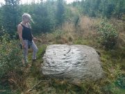
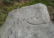
This stone was rediscovered in July 2023 during a cursory survey of other carvings in the Corrymuckloch cluster (17 and counting!). Most of the stone was covered in vegetation when first found, with just a single cupmark near its crown ensuring it got more attention. Altogether there are 10 or 11 cup-marks of varying levels of erosion across the length and breadth of the rock. The most notable one is on the northwest side of the stone, it being twice the size of the others and of much greater depth. It may originally have been a natural depression that was enhanced when the stone was carved. This larger cup has a smaller one attached just above it.
An intriguing find was noted all along the western edge of the rock, where upwards of a hundred small pieces of quartz—the majority of it crystal clear—were scattered between the stone edge and the soil. This is an ingredient that’s been noted at a number of petroglyphs in Scotland.
Take the A822 road to the northeast of Crieff and head 4-5 miles along until you enter the Sma’ Glen. You go past Ossian’s Stone and after crossing the river the road starts to go uphill. Nearly 2 miles up, the road levels out and at the left-side of the road is a small thin car-parking spot. Keep your eyes truly peeled for that! Walk through the gate and along the track (west) for 300 yards until you reach the fence. Once here, walk right (north) and go through the gate less than 50 yards away. Less than 300 yards ahead of you you’ll see a small rock outcrop. Get to it!
Archaeology & History
Rediscovered in July 2023, on this small rock outcrop it seems that only the lower east section has been carved, and it can be pretty difficult to see beneath the old layers of lichen that’s been painted across its surface. Comprising of just four cup-marks close to each other on the top of the stone, there’s a possible fifth cup to be seen on its northeast length. It’s nowt special to look at to be honest, but it’s worth checking out when you’re looking at the others in this cluster. In truth, this is another that’s only gonna be of interest to the real geeks amongst you!
Cup-and-Ring Stone (lost): OS Grid Reference – SE 0965 4797
Archaeology & History
In Ronald Morris’ (1989) gazetteer of British petroglyphs, he included this curious entry but gave no real details regarding its appearance or history. Listed by the Royal Commission lads, it would seem to have been located immediately south of the dismantled railway where it used to cross the Addingham-Ilkley road, but no one seems to have seen it either before or since Morris’ description. Any help regarding its whereabouts would be appreciated.
References:
Boughey, Keith & Vickerman, E.A., Prehistoric Rock Art of the West Riding, WYAS: Wakefield 2003.
Morris, Ronald W.B., “The Prehistoric Rock Art of Great Britain: A Survey of All Sites Bearing Motifs more Complex than Simple Cup-marks,” in Proceedings of the Prehistoric Society, volume 55, 1989.
Cup-Marked Stone (lost): OS Grid Reference – NO 074 458
Archaeology & History
In J. Romilly Allen’s (1882) lengthy essay on rock art in Scotland, he mentions a singular boulder that was “found by Dr Rattray” at Laighwood, near Butterstone—but, unlike him, he gave no further details regarding its appearance or exact whereabouts. It was included in the Royal Commission (1990) survey of the area, with no additional details. It remains lost. In the event that you manage to rediscover it, grab some good photos of it and stick ’em on our Facebook group. (the grid-reference to this site is an approximation)
Royal Commission on the Ancient & Historical Monuments of Scotland, North-East Perth: An Archaeological Landscape, HMSO: Edinburgh 1990.
Acknowledgements:Huge thanks for use of the Ordnance Survey map in this site profile, reproduced with the kind permission of the National Library of Scotland.
Cup-and-Ring Stone (lost): OS Grid Reference – NY 909 702
Archaeology & History
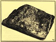
The whereabouts of this carving is somewhat of a mystery. Originally found three or four hundred yards away to the northeast of Chesters mansion, it was moved from there into the porch entranceway of the place—and here it lived for, hmmmm….well, we’re not quite sure how long it was here. The only description of the carving seems to have been made by the Rev. G.R. Hall in 1887, and between then and sometime in the 20th century, it’s disappeared to god-knows-where. The only known photo of the carving (right) suggests that the original design was somewhat bigger as the stone looks to have been broken off from a larger piece. Mr Hall told us:
“this stone is 3 feet in length by 2 feet 6 inches in breadth, of irregular form. It has five incised cups on each side of a wide, slightly curved channel, which crosses the stone at nearly its widest part. Two other grooves intersect this longest channel, one forming a segment of a circle. At the opposite end of the slab are two nearly parallel grooves passing towards the largest hollow. The ten cups vary from 1½ inches to 3 inches in diameter, and are from half an inch to an inch in depth.”
All being well, the carving is hiding in a wall somewhere, or maybe beneath His Lordship’s bed. Hopefully it’ll re-appear sometime soon…
References:
Beckensall, Stan, Northumberland’s Prehistoric Rock Carvings – A Mystery Explained, Pendulum: Rothbury 1983.
Hall, G.R., “On Some Cup-incised Stones, found in an Ancient British Burial-mound at Pitlands Hills, near Birtley, North Tynedale,” in Archaeologia Aeliana (2nd Series) volume 12, 1887.
Cup-and-Ring Stone (lost): OS Grid Reference – NU 053 128
Archaeology & History
This lost carving may have been brought to light as a result of field ploughing which, quite fortunately, uncovered a Bronze Age burial site with a cup-and-ring stone therein. It was reported by the regional historian David Dixon (1895) in his classic work on this area, although his description was brief and he made no sketch of the design. He told us:
“A stone-lined grave or cist, similar to that discovered at Mile, was found several years ago on Mountain Farm, in or near to which was a sandstone slab, covered with a fine example of the incised circles, such as are found in the rocks at Routin Lynn, Bewick Hill, Chatton Law and Lordenshaws Camp.”
These other petroglyphs he mentions are bloody impressive! Sadly they’re not yet on TNA. (site profiles required of them are considerable in size – if anyone would like to write them 😉 )
References:
Beckensall, Stan, Northumberland’s Prehistoric Rock Carvings – A Mystery Explained, Pendulum: Rothbury 1983.
Dixon, David D., Whittingham Vale, Northumberland, Robert Redpath: Newcastle-upon-Tyne 1895.