St. Giles’ Well, Lightcliffe, West Yorkshire

Holy Well (lost):  OS Grid Reference – SE 134 245

Archaeology & History

Giles’ House to centre

In times gone by there was a singular St.Giles’ Well in the old village of Lightcliffe, but the only reference we have of it is from one of James Parker’s works (1904) where, in his description of St. Giles’ House, he tells, “It derives its name from an ancient well, called ‘St. Giles’ Well,’ which once existed near to the house, and was dedicated to St. Giles”: an 8th century Greek prince who left everything to become a hermit. He lived on wild herbs and developed the ability to cure rheumatism (perhaps a curative aspect of the well), cripples and help beggars. He is the patron saint of woodlands and his symbol is the arrow gained after he healed a wounded doe shot by one (the mass of Robin Hood folklore in this area may have something to do with this symbolism).  His date is September 1.

A.H. Smith (1963) cites the “local tradition that it is named from a well dedicated to St. Giles,” but thinks this attribution to be an unlikely one.  As can be seen on the accompanying map, a great number of wells are in this area, none of them named, with one just below the said Giles House.

References:

  1. Parker, James, Illustrated History from Hipperholme to Tong, Percy Lund: Bradford 1904.
  2. Smith, A.H., The Place-Names of the West Riding of Yorkshire – volume 3, Cambridge University Press 1961.

Acknowledgements:  Huge thanks for use of the Ordnance Survey map in this site profile, reproduced with the kind permission of the National Library of Scotland

© Paul BennettThe Northern Antiquarian

Castle Hill, Kirklees, Brighouse, West Yorkshire

Enclosure:  OS Grid Reference – SE 173 216

Getting Here

Along the Brighouse to Mirfield A644 road, a half-mile east of M62’s junction 25 on Wakefield Road, note the woodland on your left-hand side, above the walling.  Although on allegedly private land, you can approach by hopping over the wall by the main road into the woods. Wander up the slope until it levels out and, just at the edge of the tree-line, past the brilliant overgrown folly amidst a mass of rhododendrons, you’ll see the denuded edges of this earthwork.  Though you might need a bitta patience seeking it out…

Archaeology & History

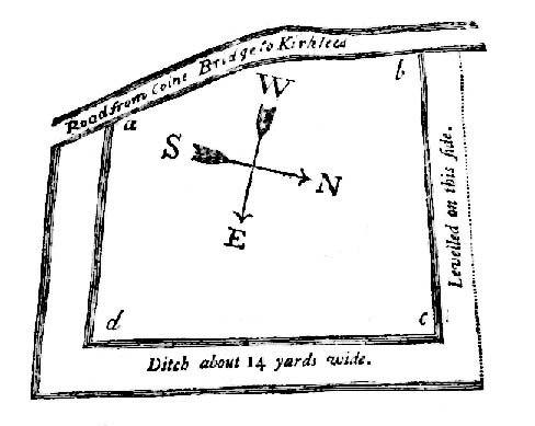
Very first sketch of this site (John Watson, 1775)

The remains of this low earthwork is found on the private land of Kirklees Hall and appointment is supposed to be made to explore, both this and the more famous Robin Hood’s Grave, a few hundred yards away. But if you can’t be bothered with that and find this little-known earthwork, you’ll see that it’s roughly squared in shape, though pretty overgrown.  In Bernard Barnes’ survey (1982) he described it as a “square or five sided enclosure, 2-3 acres in size, with bank and external ditch”, wondering whether it was used to enclosure cattle and stretching its possible origin between the Iron Age to the medieval.

Although the classical Roman archaeologist Ian Richmond (1925) believed the site to be from that period, the archaeologist J.J. Keighley thought that the site was “more likely to be Iron Age than Roman.”  He wrote:

“The earthwork in Kirklees Park is a square or five-sided enclosure with bank and external ditch… The site lies on Richmond’s trans-Pennine route.  According to Armitage and Montgomerie, the earthwork is 0.5 hectares in area, but it is actually nearer 0.8 to 1.2 hectares.  They compare its construction with the fort at Wincobank (South Yorkshire), stating that the bank on the counterscarp when excavated, revealed “a very rudely composed wall of undressed dry stone.”

Earlier local writers such as John Watson (1775) — whose early sketch of the site is reproduced above — and others also opted for the Roman date.  But, unless you’re a bit of an earthwork fanatic, this site may not be too much your cuppa tea. If you are gonna check this out though, make sure you check out Robin Hood’s old tomb in the trees not far away. Very odd.

References:

  1. Barnes, Bernard, Man and the Changing Landscape, Merseyside County Council & University of Liverpool 1982.
  2. Keighley, J.J., “The Prehistoric Period,” in West Yorkshire: An Archaeological Survey to AD 1500 (WYMCC: Wakefield 1981).
  3. Richmond, I.A., Huddersfield in Roman Times, Tolson Memorial Museum: Huddersfield 1925.
  4. Watson, John, The History and Antiquities of Halifax, J. Lowndes: London 1775.

© Paul Bennett, The Northern Antiquarian