Wellford, Fern , Angus

Standing Stone (destroyed):  OS Grid Reference – NO 483 603 (approximation)

Archaeology & History

In an area once teeming with megaliths, this is but one that lost its life in the 19th century.  It would seem that the only reference of its existence—and demise—comes from the pen of the great regional historian Andrew Jervise (1853) who, in a description of the nearby holy well of St Ninian, in a field near Wellford,

“within the last half century there were two or three large rude boulders nearby, which were called Druidical stones.”

References:

  1. Jervise, Andrew, The History and Traditions of the Land of the Lindsays in Angus and Mearns, Sutherland & Knox: Edinburgh 1853.

© Paul BennettThe Northern Antiquarian

College Well, Brechin, Angus

Sacred Well:  OS Grid Reference – NO 5945 6006

Archaeology & History

College Well on 1865 map

Highlighted on the 1865 OS-map, this lost water source was located between the Brechin cathedral/round tower and the curiously-named St. Michael’s Mount, whose history seems to be lost.  It would seem to be the well which Ruth & Frank Morris (1981) name as the ‘Ancient Well’ in their survey.

Folklore

The reason behind this site being classified as a sacred (or holy) well is based on the tradition that the Culdees had a religious convent here in the 12th century and, according to David Black (1839),

“This convent is believed to have stood a little to the west of the present parish church, in the gardens now belonging to the kirk-session, still called “the College Yards.”  A small well of delightfully pure water in these gardens receives the name of the College Well, and is reported, by tradition, to have been the well of the Culdee convent.”

On the issue of St. Michael, students of folklore will know that, in the christian cult, he was an early dragon-slayer.  His annual commemoration day is September 29.  One of his shamanistic functions “relates to the very old tradition of Michael as the receiver of the souls of the dead.” (Attwater 1965)

References:

  1. Black, David D., The History of Brechin, Alexander Black: Brechin 1839.
  2. Gibson, Colin, Folklore of Tayside, Dundee Museum c.1968.
  3. Morris, Ruth & Frank, Scottish Healing Wells, Alethea: Sandy 1982.

© Paul BennettThe Northern Antiquarian

Acknowledgements:  Huge thanks for use of the 1st edition OS-map in this site profile, Reproduced with the kind permission of the National Library of Scotland

St. Murdoch’s Well, Brechin, Angus

Holy Well:  OS Grid Reference – NO 5840 5682

Also Known as:

  1. Canmore ID 34760

Location of the Well

Location of the Well

Getting Here

The well is situated at the roadside on a grassed area at West Drum Cottages, to the east of the minor road from Hillhead of Burghill to Westerton of Aldbar, south of Brechin. The spring issues into a small circular pool, which drains as a burn southwards.

Archaeology & History

James Murray Mackinlay wrote in 1904:

“Murdoch – probably the St Mordouch invoked among the martyrs of the Dunkeld Litany……if we may believe Dempster [Thomas Dempster, 1579-1625 – Historia Ecclesiastica Gentis Scotarum, “Ecclesiastical History of the Scottish Nation.” Bologna 1627], who says that he was a hermit, and had a humble cell near a certain lake in Argyll, his cell being called Kilmurdah. Dempster further says that there was a life of the saint in nine lections, and that the events narrated in it were depicted on the walls of his cell. He is described as the last of the bards, and is said to have lived about 800 a.d.”

Dom Michael Barrett described Murdoch as a bishop, and wrote further in 1919 :

“No very reliable particulars can be ascertained as to the life of this saint. Traces of the honour shown to him are to be found in Forfarshire, the district which seems to have been the scene of his missionary labours. At Ethie, in the parish of Inverkeilor, in that county, are the remains of an ancient church and burial-ground which bear his name.”

Near Ethiebeaton, in the parish of Monifieth, are traces of an old church which goes by the name of ‘Chapel Dockie’. This is believed to be another dedication in honour of St. Murdoch.”

Murdoch may be an anglicisation of either Muireadhach, now Murray, or Muircheartach, which is now Murtough.  Murdoch’s Saint’s day is 2nd September, but 5th October and 23rd December have also been given. And Barrett also writes of a Saint Moroc, who, if what Mackinlay writes is correct, may be the same person as St Murdoch.

Looking into the waters

Looking into the waters

The small run-off from the well

The clear waters of the well

The spring was flowing strongly on the sunny February day of my visit, but its neat appearance gives no idea of it being a Saint’s Well to the passing traveller, who would probably think it to be just a pleasant water feature of the garden of the adjacent house. Perhaps there should be some representations made to the local tourist office for a sign to be placed by the well.

A mile or so to the north, hiding at the edge of a small copse of trees, is the little known holy well of St. Ouret.

References:

  1. Barrett, Dom Michael, A Calendar of Scottish Saints, Abbey Press, Fort Augustus 1919.
  2. Forbes, Alexander Penrose, Kalendars of Scottish Saints, Edmonston and Douglas, Edinburgh 1872.
  3. Mackinlay, James Murray, Influence of the Pre-Reformation Church on Scottish Place-Names, William Blackwood and Sons, Edinburgh & London 1904.

© Paul T. Hornby, The Northern Antiquarian 2016


St. Ouret’s Well, Brechin, Angus

Holy Well:  OS Grid Reference – NO 5869 5904

Getting Here

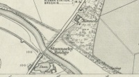
‘Spring’ shown on 1865 map

Travel north towards Brechin on the B9134, and cross the River South Esk at Stannochy Bridge.  Immediately after crossing the bridge, go through the double tubular steel gates to your right, descend the steep slope and walk along the boundary fence dividing the riverside field from the sloping woodland until you reach a tubular steel pedestrian gate. Go through this gate, over the burn and keep walking 150 yards or so to the right and St. Ouret’s Well is seen near the top of the slope.

Archaeology & History

Alexander Penrose Forbes, Bishop of Brechin wrote in 1872 :

Ouret – Close to Brechin, on the north bank of the Esk, near the Stannochy Bridge, is S.Ouret’s Well.”

The spring flows south into a burn then into the river South Esk

Perusal of the 25″ OS map of 1865 shows an enclosure marked ‘spring’ with a short pathway to the north-east, as the only water feature answering the written description. My field visit just over a century and a half later found a spring issuing at that point from the embankment, with the remains of old rough stone walling on either side of the spring. There was no sign of the pathway. The walling around an otherwise unremarkable spring located away from habitation would imply to me that this is the Saint’s Well.

As the good Bishop mentions the Well as the last entry in the Auctaria of his 1872 book—an afterthought as you will—it seems reasonable that the knowledge of St. Ouret and his well may have been at that time on the point of oblivion. The well is not noted as such by the earlier Ordnance Survey map,  nor can I find his name in any other of the hagiographies at my disposal.

Old walling still visible low down

Intriguingly, ‘Ouret’ is a modern Basque surname, and while it is tempting to think of a Basque Holy Man walking the Pictland, the name is more likely a transliteration into Scots from a now lost Pictish or Gaelic name.  There is a mysterious ‘Uoret’ named in the inscription (as interpreted by Elisabeth Okasha) ‘DROSTEN : IRE UORET [E]TT FORCUS’  on the Drosten Stone at St Vigeans, who may be our saint, but this Uoret has been interpreted by Thomas Clancy as the Pictish King Uurad, son of Bargoit, who ruled from 839 to 842.  I know of no reference as to where Forbes obtained his information on Ouret or his well, but is it reasonable to hypothesise that the information was passed to him orally and what he wrote down as ‘Ouret’ may have been meant to be the very similar sounding ‘Uoret’? Or alternately was King Uurad  subjected to local canonisation as St Uoret/Ouret after his death? Can anyone add more?

A mile or so south of here is the holy well of St. Murdoch.

References:

  1. Forbes, Alexander Penrose, Kalendars of Scottish Saints, Edmonston and Douglas: Edinburgh 1872.
  2. Dwelly, Edward, Gaelic – English Dictionary, Garmin Publications: Glasgow 1988

© Paul T. Hornby,  The Northern Antiquarian 2016


White Caterthun Carving, Menmuir, Angus

Cup-Marked Stone:  OS Grid Reference – NO 54671 66022

Also Known as:

  1. Canmore ID 35007

Getting Here

White CaterthunCR01

The carving below the walling

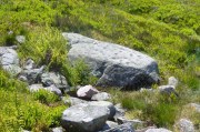
Many ways here, but from the nearest town of Brechin, take the minor north road out of town (not the B966) to Little Brechin, heading roughly north to the renowned hillforts of White and Brown Cathertun (ask a local if needs be).  Park up and walk up the slope to White Cathertun, following the immense walling around to the right.  Near where you reach the opposite side of the hillfort, look down the rocky slopes for a large boulder, just on the edge of the walling.  You’ll find it!

Archaeology & History

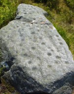
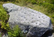
Although Canmore include this cup-marked stone in the site-profile of the incredible White Caterthun hillfort, it should really have an entry of its own, as it’s age and nature very probably pre-date the construction of the giant fortress.  But, this aside, if you’re visiting the hillfort (an incredible place!), at least give this heavily cup-marked stone your attention too.

Looking across the carving

Looking across the carving

Close-up of the main cups

Close-up of the main cups

Probably neolithic in origin, there was a small portable cup-marked companion found 30 yards away, suggesting perhaps that a cairn might once have stood on this hilltop—but tradition is silent on the matter.  No other petroglyphs of any note have been located nearby, which is unusual.  In all probability other carvings remain undiscovered, particularly in the hills immediately to the north.

Consisting of around 80 cup-marks, several of which appear linked by carved lines, the stone has been bound together with concrete and metal bolts after some idiot damaged it in the 19th century.  It was first described by Miss Christian Maclagan (1875) in her stunning megalithic survey of the period.  She wrote:

“To Sir James Simpson’s list of cup-markings we are able to add the one at the Caterthun, on a large block 6 feet long, which is quite covered with very distinctly cut cup-markings.  It is a block of basalt…and the cups are so very clear and sharp in their lines that their freshness can only be accounted for by the stone having lain with the markings buried in the ground.  This curious stone has been quite recently broken in two.  It is a pity to see it so destroyed, because it is valuable to the antiquary in helping to establish a very remote antiquity for the fortification.  It lies on the north side of the fort, among a chaos of stones, having probably once formed the side of a gateway.”

A few years later the late great J. Romilly Allen (1882) visited the site and gave us his description, telling:

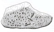
“On the west side (of the hillfort), 10 yards north of the boundary of the fir plantation that covers one-half of the hill is a cup-marked boulder… The stone has been broken in two, and one portion of it lies at the foot of the stone rampart just above the first outer ditch, whilst the other half has been rolled down the hill by some mischievous person with more muscles than brains, and is to be found immediately below, where its further progress was arrested by coming in contact with the outermost wall.  The two fragments when placed together measure 6 feet 9 inches long by 3 feet wide, and 1 foot 9 inches thick.  The stone is greenish quartzose slate, and on its upper surface are carved eighty cups, varying from 1½ to 2½ inches diameter.  In two cases two cups are united into one by a connecting groove.”

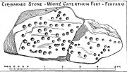
J. Sherriff's 1995 drawing

J. Sherriff’s 1995 drawing

J.R. Allen's 1882 drawing

J.R. Allen’s 1882 drawing

The most recent description and illustration of the stone is in John Sherriff’s (1995) survey. When we visited the carving recently we noticed three cup-marks etched onto the side of the stone, with a possible carved line running above one of them—but due to the bright sunlight on of the day of our visit, it was difficult to say whether this was a geological in nature or not (bright daylight can hamper good visibility of many carvings).  Check it out!

References:

  1. Allen, J. Romilly, “Notes on some Undescribed Stones with Cup Markings in Scotland,” in Proceedings of the Society of Antiquaries Scotland, volume 16, 1882.
  2. Kenworthy, J., “White Caterthun: Cup-Marked Stone”, in Discovery & Excavation, Scotland, 1980.
  3. MacLagan, Christian, The Hill Forts, Stone Circles and other Structural Remains of Ancient Scotland, Edmonston & Douglas: Edinburgh 1875.
  4. Sherriff, John, “Prehistoric Rock-Carvings in Angus,” in Tayside & Fife Archaeological Journal, volume 1, 1995.

© Paul BennettThe Northern Antiquarian


Ghaist Stane, Fern, Angus

Standing Stone:  OS Grid Reference – NO 4832 6173

Getting Here

Ghaist Stane on 1865 OS-map

Ghaist Stane on 1865 OS-map

Whichever route you take to reach this lovely hamlet, hiding away in deep greenery, when you get to the one and only road junction, where it goes downhill (towards the old church), look just above you just below the first tree.  All but covered in vegetation, the ruined stone lays down there. Climb up and see!

Archaeology & History

Tis up on the verge here

Tis up on the verge here

An exploration of this site was prompted when fellow antiquarian, Paul Hornby, came across the curious place-name of ‘Ghaist Stane’ when he was looking over some old Ordnance Survey maps of the region.  So we met up and took a venture over there!  Last highlighted on the 1865 map (when the old village was known as Fearn, not the modern spelling), even the Canmore lads had missed this one.  But it’s not easy to find….

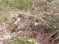
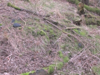
After meandering back and forth by the village roadside, on the tops of the walls, into the field above, Paul eventually said, “Is that it?!” just above the roadside, almost buried in vegetation below the roots of a tree.  So I clambered back up and brushed some of the vegetation away – and there it was – in just the place that the old OS-map showed it to be (give or take a few yards).

The remains of the stone measure roughly 3 feet by 3 feet; with the present upper portion of the stone being of a lighter colour than the lower portion, indicating that this section of the stone was the portion that was underground when it was standing upright.  Its history is fragmentary, but we know that it was almost completely destroyed in the middle of the 19th century.  Notes from the Object Name Book of the region in 1861 told,

“The “Ghaist Stane”…formerly well known, is becoming little known from the stone having been recently blasted in making the Dike it now forms a part of, but it may be observed in the wall as a huge stone much larger than those beside it in the Dike. It does not project now from the side of the Road.”

Now the stone is almost entirely forgotten and lays covered, ignored, even by local people.  It could do with being resurrected and its heritage preserved before it disappears forever.

Folklore

The uncovered Ghaist Stane

The uncovered Ghaist Stane

The word “ghaist” is a regional dialect word meaning “a ghost or goblin”, inferring that the site was haunted.  And, considering the inherent animistic cultural psychology of the people here in earlier centuries, we must also consider the distinct possibility that the stone itself was the abode of a resident spirit, perhaps an ancestral one of a local chief, or queen, or elder of some sort.

In James Guthrie’s (1875) analysis of the folklore of Fern township, he told of the peculiarly odd violent brownies of the district and thought that they and the spirit of the Ghaist Stane were one and the same.

“In addition to the leading characteristics of Brownies in general the more prominent of these being, that they forded the rivers when their waters were at their highest, and that the sage femme always landed safely at the door of the sick wife—the brownies of Ferne are connected with scenes of cruelty and bloodshed.  This peculiarity would seem to indicate that the brownie and the ghaist of Feme, were one and the same.  The Ghaist Stane is in the vicinity of the church.   To this piece of isolated rock, it is said this disturber of the peace was often chained as a fitting punishment for his misdeeds, but tradition is silent as to the brownie being similarly dealt with, which strengthens the supposition that they were, in this quarter at least, generally regarded as one being.”

The spirit of the Ghaist Stane roamed far and wide in the district it seemed, and a long rhyme telling a tale of the ghaist was once well-known in the area which, thankfully, Mr Guthrie gave us in full:

THE GHAIST O’ FERNE-DEN

There liv’d a farmer in the North,
(I canna tell you when),
But just he had a famous farm
Nae far frae Feme-den.
I doubtna, sirs, ye a’ hae heard,
Baith women folks an’ men,
About a muckle, fearfu’ ghaist —
The ghaist o’ Ferne-den!
The muckle ghaist, the fearfu’ ghaist,
The ghaist o’ Ferne-den;
He wad hae wrought as muckle wark
As four-au’-twenty men!

Gin there was ony strae to thrash,
Or ony byres to clean,
He never thocht it muckle fash
0′ workin’ late at e’en!
Although the nicht was ne’er sae dark,
He scuddit through the glen,
An’ ran an errand in a crack —
The ghaist o’ Ferne-den!

Ane nicht the mistress o’the house
Fell sick an’ like to dee,—
“O! for a oanny wily wife!”
Wi’ micht an’ main, cried she!
The nicht was dark, an’ no a spark
Wad venture through the glen,
For fear that they micht meet the ghaist —
The ghaist o’ Ferne-den!

But ghaistie stood ahint the door,
An’ hearin’ a’ the strife,
He saw though they had men a score,
They soon wad tyne the wife!
Aff to the stable then he goes,
An’ saddles the auld mare,
An’ through the splash an’ slash he ran
As fast as ony hare!

He chappit at the Mammy’s door—
Says he — “mak’ haste an’ rise;
Put on your claise an’ come wi’ me,
An’ take ye nae surprise!”
“Where am I gaun?” quo’ the wife,
“Nae far, but through the glen —
Ye’re wantit to a farmer’s wife,
No far frae Ferne-den!”

He’s taen the Mammy by the hand
An’ set her on the pad,
Got on afore her an’ set aff
As though they baith were mad!
They climb’d the braes—they lap the burns—
An’ through the glush did plash:
They never minded stock nor stane,
Nor ony kind o’ trash!

As they were near their journey’s end
An’ scudden through the glen:
“Oh!” says the Mammy to the ghaist,
“Are we come near the den!
For oh! I’m feared we meet the ghaist!”
“Tush, weesht, ye fool! “quo’ he;
“For waur than ye ha’e i’ your arms,
This nicht ye winna see!”

When they cam to the farmer’s door
He set the Mammy down:—
“I’ve left the house but ae half hour—
I am a clever loon!
But step ye in an’ mind the wife
An’ see that a’ gae richt,
An’ I will tak ye hame again
At twal’ o’ clock at nicht!”

“What maks yer feet sae braid?” quo’ she,
“What maks yer een sae sair?”
Said he, — “I’ve wander’d mony a road
Without a horse or mare!
But gin they speir, wha’ brought ye here,
‘Cause they were scarce o’ men;
Just tell them that ye rade ahint
The ghaist o’ Ferne-den!”

References:

  1. Guthrie, James C., The Vale of Strathmore – Its Scenes and Legends, William Paterson: Edinburgh 1875.

© Paul BennettThe Northern Antiquarian