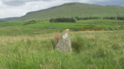
Chapel Well, Clackmannan, Clackmannanshire

Holy Well:  OS Grid Reference – NS 9125 9122

Archaeology & History
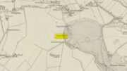
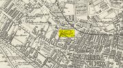
Chapel Well on 1866 map

A little-known holy well on the south-side of the village has seen better days – if indeed it’s still there!  Located 500 yards due south of the destroyed Lady Well, this spring of water gained it name, according to local lore, from its proximity to an ancient chapel—remains of which have been frugal to say the least!  Shown on the earliest Ordnance Survey maps and continued to be shown until the 1950s, it seems that the first written account of it was in the Object Name Book of 1861 where it was told:

“A Spring well adjacent to Chapelhill.  It is cut in a freestone rock, from which issues a constant supply of pure spring water even in the dryest Seasons.  It is not impregnated with any Kind of Mineral.  A Chapel Stood near it at one time, the site of which Cannot be pointed out by any person in the neighbourhood.”

A visit by one of the Ordnance Survey lads here in 1950 found the well to be blocked-up by silt and soil; and on a quick visit I made here today I could find no remains of the well, but it may have been beneath the mass of excessive vegetation.  A subsequent visit in the winter may prove more fruitful – he sez, hopefully…..

© Paul BennettThe Northern Antiquarian

Denny Bridge, Denny, Stirlingshire

Cist (destroyed):  OS Grid Reference – NS 808 830

Archaeology & History

A small and seemingly prehistoric grave, or cist, destroyed sometime around 1840, once existed on the top of a large hillock close to the River Carron where the bridge leads from Dunipace to Denny.  Thankfully, memory of its existence was preserved by Robert Watson (1845) in his short description of Dunipace parish.  He first began by talking of some large natural mounds on the eastern side of the township which, folklore told, gave rise to the place-name Dunipace; but from those mounds,

“About two miles to the westward of these hills, there was a very beautiful one about forty feet in height, and covering nearly three roods of ground, said also to be artificial.  This hill was mutilated, from time to time, for the purpose of repairing roads and other purposes.  It was entirely removed about six years ago, to form an embankment on the turnpike road near Denny bridge. The strata of which this hill was composed, were carefully observed during its removal. These were so regular, and as if rising out of, and gradually returning again to similar strata in the circumjacent level ground, as to afford conclusive evidence that the hill was not the work of man.  On the top of this hill, and about three feet below the surface, was found a coffin or tomb, composed of five large un wrought stones, in which were the bones of a human body, scull and teeth not much decayed.  Along with these, was a vase of coarse unglazed earthenware, containing a small quantity of material resembling the lining of a wasp’s nest, probably decayed paper or parchment, which in the lapse of ages had assumed that appearance.  No conjecture could be formed about the individual here interred, tradition being entirely silent on the subject ; but this circumstance corroborates the opinion of some writers, that the hills of Dunipace might have been used as burying-places for ancient chiefs.”

The site was included in the Royal Commission’s (1963:1) Inventory, but they found no additional data about it.

References:

  1. Royal Commission on the Ancient & Historical Monuments Scotland, Stirling – volume 1, HMSO: Edinburgh 1963.
  2. Royal Commission on the Ancient & Historical Monuments of Scotland, Archaeological Sites and Monuments of Stirling District, Central Region, Society of Antiquaries of Scotland 1979.
  3. Watson, Robert, “Parish of Dunipace,” in New Statistical Account of Scotland – volume 8, William Blackwood: Edinburgh 1845.

© Paul BennettThe Northern Antiquarian 

Market Cross, Aynho, Northamptonshire

Cross (destroyed):  OS Grid Reference – SP 514 332

Archaeology & History

In John Bridges’ (1791) account of the parish of Aynho, he made mention of an old market cross that stood in the village, but even in his day it had been removed and so we know little about it.    Chris Markham (1901) included it in his inventory of crosses, but could find no additional details to those provided by Mr Bridges.  He told us:

“In the seventeenth year of Edward II (1323-4) John de Clavering was lord of the manor of Eynho, and obtained the King’s charter for a weekly mercate, or market, to be held every Tuesday, and a yearly fair on the vigil and day of St. Michael and two days following.  This market was continued until the twentieth year of James I (1622-3), when Richard Cartwright obtained a new charter for holding the market and fair, with the addition of another yearly fair on the Monday and Tuesday after Pentecost.  Bridges, however, writing about 1700, says that the market had been discontinued for some sixty years, and that the market cross had been then long since taken down. Since then the fairs have also sunk into desuetude.”

References:

  1. Bridges, John, The History and Antiquities of Northamptonshire – volume 1, T. Payne: Oxford 1791.
  2. Markham, Christopher A., The Stone Crosses of the County of Northampton, Simpkin Marshall: London 1901.

© Paul BennettThe Northern Antiquarian

St Peter’s Well (1), Leeds, West Yorkshire

Holy Well (destroyed):  OS Grid Reference – SE 2894 3382

Archaeology & History

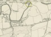
St Peters Well on 1852 map

Not to be confused with the other St. Peter’s Well that once existed in the city centre, this site was shown on an 1815 map of Leeds (which I’ve not been able to get mi hands on!), known as the Waterloo Map.  But when the Ordnance Survey lads visited the place in 1846, it had been covered over.  Immediately west of here, the saint’s name was also given to a nearby hill, whose folklore seems has been forgotten.

Although Ralph Thoresby mentioned it in passing, Edward Parsons (1834) gave us a brief description of its qualities, telling us that,

“Near North Hall is the celebrated spring called St. Peter’s Well ; the waters are so intensely cold that they have long been considered very efficacious in rheumatic disorders.”

Bonser (1979) reiterated this in his survey, also telling that, like its nearby namesake, its waters were “intensely cold and beneficial for rheumatism, rickets, etc.”  An old bathing-house that was “annexed to the Well” may have been used specifically to treat such ailments, but we cannot say for sure.

Interestingly, Andrea Smith (1982) told that 400 metres away a well was sunk in 1838 and a quantity of petrified hazelnuts were recovered from a broken red jar which had a female head painted on it.  Such a deposit is not too unusual, as a number of sacred wells in bygone days were blessed with nuts and signified the deity Callirius, known by the Romans as Silvanus, the God of the Hazel Wood – though we have no direct tradition here linking St. Peter’s Well with this ritual deposit.

St. Peter’s festival date was June 29.

References:

  1. Bonser, K.J., “Spas, Wells and Springs of Leeds,” in The Thoresby Miscellany – volume 54, Leeds 1979.
  2. Hope, Robert Charles, Legendary Lore of the Holy Wells of England, Elliott Stock: London 1893.
  3. Parsons, Edward, The Civil, Ecclesiastical, Literary, Commercial and Miscellaneous History of Leeds, Halifax, Huddersfield, Bradford, Wakefield, Dewsbury, Otley – volume 1, Frederick Hobson: Leeds 1834.
  4. Smith, Andrea, ‘Holy Wells Around Leeds, Bradford & Pontefract,’ in Wakefield Historical Journal 9, 1982.
  5. Thoresby, Ralph, Ducatus Leodiensis, Maurice Atkins: London 1715.

© Paul BennettThe Northern Antiquarian

Gerchew Well, Balfron, Stirlingshire

Healing Well (lost):  OS Rid Reference – NS 579 884

Archaeology & History

One-and-a-half miles east of Balfron, this curiously-named well could once be seen – and indeed may still be there.  Mentioned just once in D.S. Buchanan’s (1903) Guide as a well-known place, I’ve been unable to locate it and can find no other accounts of the place. He wrote:

“A little beyond Dailfoil there is a road to the right, down which, about 200 yards, there is a stile over the fence, only a few feet from the famous Gerchew Well, on the banks of the Endrick.  Here the visitor can repose for a time under the shade of the trees, and quench his thirst in its pure, cool, and bubbling waters.”

His directions seem to indicate it as being just off the small road that runs to the ruins of Easter Gerchew, but there is nothing of note hereby.  A half-mile away was Wester Gerchew house, which seems contrary to his directions —and there’s nothing in evidence there either.  And so I enter it here in the hope that someone might be able to relocate this healing well. (the grid reference is an approximation based on Buchanan’s description)

References:

  1. Buchanan, D.S., Buchanan’s Popular Illustrated Guide to Strathendrick, Aberfoyle and District, J. & C. Buchanan: Balfron 1903.

© Paul BennettThe Northern Antiquarian

Balgair Moor, Fintry, Stirlingshire

Standing Stone:  OS Grid Reference – NS 60774 90383

Getting Here

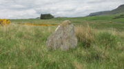
Balgair Moor stone

Go up the B822 road from Fintry for literally 2.5 miles (about 500 yards below the small copse of trees that almost hide Balafark Farm above you) and at a very small ‘parking’ spot are 2 farm-gates.  Go through the lower of the two and head downhill, crossing the small burn and up the other side for just over 100 yards where you’ll meet a very low, old and very overgrown wall.  Keep your eyes peeled for it!  Walk left along this wall, uphill, for another 100 yards till you meet a a dried-up dyke that runs downhill.  10-15 yards down this, a small stone greets you…

Archaeology & History

It’s difficult to call this a ‘standing stone’ and, as far as I’m concerned, is even more troublesome to cite it as a legitimate prehistoric monument.  Nevertheless it is shown on the modern OS-maps as such and was listed by the Royal Commission (1963:1) lads in their standing stones inventory.  But it’s really pushing it to be honest!  They told us:

“This stone stands about 180 yds NW of a gate which opens off the Fintry-Kippen road, 340 yds N of its crossing of the Lernock Burn.  It is triangular in profile and wedge-shaped in section, measuring 3’3″ both in height and breadth along its base, by 1’7″ in greatest thickness.  It may well have been a boundary stone as it is near the corner of some ground which is enclosed by a turf dyke and has been cultivated.”

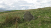
Looking southwest
Looking up to the ancient cairn of Stronend

In truth, if we call this a standing stone, then there are hundreds of others that I’ve come across over the years—frobbling off-path across huge swathes of moorland—that must also be added to our prehistoric inventories, as the height of this isolated rock is echoed in countless others which are off the archaeological listings.   One such stone ‘stands’ 100 yards northeast of here—although there are many others with  much greater potential.  …I think the only thing that may sway this as being a possible prehistoric upright is the fact that the top of the stone appears to have been broken off, albeit a few hundred years ago if the weathering is owt to go by.   But a cursory look for any broken top-piece found nothing.

References:

  1. Royal Commission on the Ancient & Historical Monuments Scotland, Stirling – volume 1, HMSO: Edinburgh 1963.

© Paul BennettThe Northern Antiquarian

St. Pancras’ Well, Scampton, Lincolnshire

Holy Well (destroyed):  OS Grid reference – SK 9542 7853

Archaeology & History

Site shown on 1886 map

Mentioned in Thompson’s (1999) survey but without comment, it was, curiously, Skyring Walters’ (1928) that drew my attention to this site.  He added it to his list of St Pancras sites, telling how even in his day, it had fallen into memory.  Indeed, it had already gone when the Ordnance Survey lads came here in 1885.  Thankfully we were left with an albeit piecemeal account of the place by Cayley Illingworth (1810) before its destruction. It was an iron-bearing well that existed some fifty yards from an ancient Roman villa and was probably the water supply for the Romans who lived here.  He told us:

“The circumstance…of the chalybeate spring within a few yards from the entrance of the villa, and still called Saint Pancras Well…favours the conclusion of a chapel having been erected on its site.  (This) is supported by the strong evidence of a discovery, upon record, that a chapel dedicated to Saint Pancras did actually exist on this spot, so early as the beginning of the twelfth century; about which period Richard Fitz-Robert of Scampton gave to the monastery of Kirksted three selions of land in that lordship, two of which are described in the gift as lying in the south field, on the south side of the chapel of Saint Pancras.”

He further told that at the bottom of the well an oak floor had been laid, which had been dug up “several years ago.”

St Pancras’s festival date is April 3.

References:

  1. Cameron, Kenneth & Insley, John, The Place-Names of Lincolnshire – volume 7, English Place-Name Society: Nottingham 2010.
  2. Harte, Jeremy, English Holy Wells: A Sourcebook – volume 2, Heart of Albion Press: Loughborough 2008.
  3. Illingworth, Cayley, A Topographical Account of the Parish of Scampton in the County of Lincoln, T. Cadel & W. Davies: London 1810.
  4. Thompson, Ian, Lincolnshire Springs and Well, Bluestone: Scunthorpe 1999.
  5. Walters, R.C. S., The Ancient Wells, Springs and Holy Wells of Gloucestershire, St Stephens Press: Bristol 1928.

© Paul BennettThe Northern Antiquarian

Village Cross, Leighterton, Gloucestershire

Cross (destroyed):  OS Grid Reference – ST 824 910

Archaeology & History

Charles Pooley (1868) gave a somewhat vague description of this site, telling that, “there is authority for believing that at one time a Cross was set up in the village.”  I can find no other reference to this monument which, I presume, has been destroyed.  (the grid reference cited is an approximation near the centre of the village, where village crosses were usually located)

References:

  1. Pooley, Charles, Notes on the Old Crosses of Gloucestershire, Longmans Green: London 1868.

© Paul BennettThe Northern Antiquarian

St Pancras’ Well, Marshfield, Gloucestershire

Holy Well (lost):  OS Grid Reference – ST 766 743

Archaeology & History

In R.C. Skyring Walker’s (1928) fine survey of Gloucestershire’s holy wells, he lamented the passing of this site, telling how

“it is sad to relate that this well has totally disappeared and its precise site is unknown.”

Since those words, the situation regarding its whereabouts has not been resolved.  First mentioned in Samuel Rudder’s (1779) work, the main clue we’ve got regarding its whereabouts is his description of the adjoining hamlets and village tithes:

“Westonton, formerly called Old Marshfield, or Little Marshfield.  It has been a distinct parish, called St Pancras, according to Sir Robert Atkins, and a well in this hamlet still bears the name of that saint.”

‘Well’ on 1886 OS-map

Westonton is the old farmhouse of Westend Town less than a mile northwest of Marshfield where, on early Ordnance Survey maps, a Well is shown.  To the north of this is Springs Farm.  This latter name probably has no bearing on St Pancras’ Well; but the location cited by Rudder of the well being in Westend Town gives us a damn good indicator as to where local historians should dig for this forgotten sacred site.

The Well was described in T.D. Fosbroke’s (1807) work, but only in passing.  St Pancras’s festival date is April 3. (the grid reference cited for this well is an approximation)

References:

  1. Fosbroke, Thomas D., Abstracts of Records and Manuscripts Respecting the County of Gloucester – volume 2, J. Harris: Cirencester 1807.
  2. Rudder, Samuel, A New History of Gloucestershire, S. Rudder: Cirencester 1779.
  3. Smith, A.H., The Place-Names of Gloucestershire – volume 3, Cambridge University Press 1964.
  4. Walters, R.C. S., The Ancient Wells, Springs and Holy Wells of Gloucestershire, St Stephens Press: Bristol 1928.

© Paul BennettThe Northern Antiquarian

Slaughter’s Well, Lechlade-on Thames, Gloucestershire

Healing Well (destroyed):  OS Grid Reference – SU 215 995

Archaeology & History

Not listed in the field-name surveys of the town, the name Slaughter Well was obviously a folk-name given to it by local people.  The place was mentioned in an unpublished manuscript that Adin Williams’ (1888) managed to lay his hands on, where it was mentioned in relation to the missing pyramidal Market Cross.  Its waters were “said to be medicinal.”  The name of the well was said to derive from a battle here between Oliver Cromwell’s men and the Royalists.  At this place,

“an officer was shot, and this incident gave the name ‘Slaughter’ to the well.”

References:

  1. Williams, Adin, Lechlade: Being the History of the Town, Manor and Estates, The Priory and the Church, E.W. Savory: Cirencester 1888.

© Paul BennettThe Northern Antiquarian