Montalt, Dunning, Perthshire

Cup-Marked Stone:  OS Grid Reference – NO 06 13

Also Known as:

  1. Canmore ID 26675
  2. Mount Alt Farm

Archaeology & History

Montalt’s curious cup-marked stone

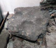
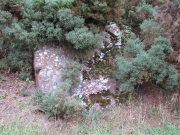
This is a curious stone and may not be the type of ‘cup-marked’ rock we’re used to.  Maybe… It is presently housed in Stirling’s Smith Art Gallery & Museum, where a small note tells that is was originally found “on the top of the Ochils, near Mount Alt Farm, Path of Condie in 1893.”  The stone was found at the same time, and adjacent to, a prehistoric collared urn—which implies it had an association with a cairn or cist, or burial site of some sort (which isn’t uncommon).  However, the exact location of its original whereabouts has been forgotten.

Broken off from a larger piece of stone, the remaining piece of rock has six cup-markings cut into it, between one and three inches across.  The smallest cup is what we might call a ‘normal’ size, but the rest of them get increasingly large and may have been more functional than purely mythic in nature.  In a small note attached to the stone in the Museum, they add the interesting note that,

“There are…indications that in some places they may be related to transhumance: the practice of moving sheep, cattle and goats to higher pastures in the summer, where they may have been used to mark routes or sources of water.”

They may indeed – amongst a variety of other things too.  But the suggested relationship with cattle occurs in stones found near Haworth, West Yorkshire, where large man-affected carved ‘cups’ such as the ones here, were known to be filled with milk at specific times of Nature’s calendrical rhythms, for the spirits of the place to give good fortune to the farmer and local people.  We know of one instance where this practice still occurs and goes back generations in the same family.  Examples of this animistic practice have also been found in the Scottish Highlands.

© Paul BennettThe Northern Antiquarian


Pitcur Souterrain (3) – Carving 2, Kettins, Perthshire

Cup-and-Ring Stone:  OS Grid Reference – NO 25290 37378 

Getting Here

MacRitchie’s 1900 groundplan

Follow the same directions as if you’re visiting the Pitcur (3) souterrain.  Once here, you’re standing at the southernmost uncovered section of the monument, where one uncovered passageway bends round and meets up with another open section (“m” on MacRitchie’s plan, right).  From here, just to your right, a single large roofing stone joins one side of the open passageway with the other, enabling you to walk across it—and the stone you’d walk across has these very faint carvings on it.

Archaeology & History

Shortly before darkfall a few weeks ago, Nina Harris, Frank Mercer, Paul Hornby and I were just about ready to pack-up and leave the brilliant Pitcur souterrain with its underground chambers and various petroglyphs when, as I walked along one of the open passages beneath one of the monument’s many large capstones, my fingers gently stroked the rock above me, almost unconsciously.
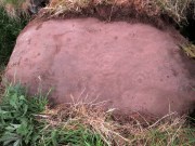
First photo of the carving (by Paul Hornby)

“Was that a faint cup-mark?” I asked myself, fondling gently the smooth stone once more.

Standing eight-feet above me in the long grasses, Mr Hornby was gazing around in his usual way.

“Paul – can you see from up there if this is a cup-marking I’m feeling here?”

Walking onto the edge of the rock itself, he proclaimed, “it looks like it!”

It was indeed!  And during the remaining 30 minutes of daylight we found that the single cup-mark had a number of companions on the same stone.  With multiple rings!  Twas another good day out.
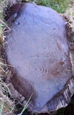
Carving when wet (photo, Frank Mercer)
Looking straight down

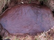
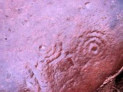
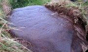
Previously unrecorded, this large rounded stone just about covers the space across from one side of the souterrain passage to the other, measuring roughly 6 feet by 4 feet, with its longer axis positioned roughly east-west.  It was on the westernmost edge of the stone where I located the first single cup-mark, close to the edge, but there are perhaps 12  others: three of which, as the photos show, are in a straight line from near the west-side of the stone to the upper-middle.  On its far eastern edge, another cup-mark is clearly evident; whilst on its southernmost edge is another.  It’s the middle and eastern section of the rock that grabs most of the attention.  Here we found the very faint rings becoming clearer and clearer as the dust of ages was carefully swept away, eventually giving us vision of carvings that were, in all likelihood, first pecked into the rock in the neolithic period, 4-6000 years ago.
Close-up of the 2 triple-rings
Cup-and-rings at an angle

As we can see, two faint triple-rings exist, each with lines running in/out of them.  The eastern concentric system is just about complete and has a small cup-mark on the NW edge of the outer ring.  A line that runs out from the central cup meets another carved line which, from some angles, appears to look almost like a bowl beneath the triple rings—but this is unclear.  The other triple cup-and-ring, slightly closer to the middle of the stone, has an incomplete outer ring, with evidence of another line running outwards from its central cup. There seems to be a slightly-pecked outline of a single cup-and-ring on the north side of the stone, but this is also unclear.

In truth we need to revisit the site soon, when the lighting gives us a clear idea of what we actually found, because our visit here was cut short by encroaching night and a grey cloudy evening—which are not the best conditions for isolating new petroglyphs!

At least six other petroglyphs exist within the Pitcur Souterrain (3), with the one closest to this (Pitcur 3:3) also used as a roofing stone, covering the deep trench from one side to the other.  However, it would appear the petroglyphs on that stone were on its underside, as the erosion on it is negligible, away from the elements—unlike this one! Another capstone that was also turned over (Pitcur 3:4) was found to possess more cup-and-rings, again on the underside of the stone.

This carving was probably executed 2-3000 years before the souterrain came into existence, and as a result of this we’re unsure as to the original location of the stone—but it was probably close by.  It might have originally been a carved standing stone, re-used here; or been part of a lost prehistoric tomb; or even a loose earthfast rock (though this is the least likely of the three).  Why it was used, and whether it retained any sense of the original meaning when it was re-positioned into the present construction, is a relevant question.  In all likelihood some of the original mythic element—or a morphed development of its original animistic narrative–was probably a functional ingredient of importance to the souterrain builders, 2-3000 years after the carving had been made.

A superb site!

References:

  1. Wainwright, F T., The Souterrains of Southern Pictland, RKP: London 1963.

Acknowledgements:  This site profile would not have been made possible were it not for the huge help of Nina Harris, Frank Mercer & Paul Hornby.  Huge thanks to you all, both for the excursion and use of your photos in this site profile. 🙂

© Paul BennettThe Northern Antiquarian


Samson’s Stone, Waltonhill Farm, Craigrothie, Fife

Legendary Stone: OS Grid Reference – NO 36312 09667

Getting Here

Lighter coloured Samson Stones visible from road south of farm

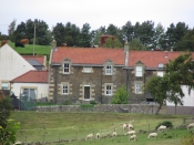
Travelling South along the A916 just past Craigrothie, turn right down to Chance Inn, and turn left at the T junction. and follow the road on to just past the left hand bend when Waltonhill Farm will be seen on the right. The Stones form part of the structure of a dwelling house and are not accessible to the public, but are visible from the public highway further down the road as the light coloured irregular shaped stones at ground level either side of the door of the south-facing house.

Archaeology & History

According to a piece published in the Fife Herald & Journal in 1905:-

“Once upon a time, so runs the legend, Samson challenged the devil to match him at boulder throwing. As challenger, Samson stood on the West Lomond; Satan stood on the East. The signal was given; two mighty rocks whistled through the air. ‘The De’ils Stane‘ fell where it now lies, on the road-side about a quarter of a mile west from Waltonhill Farm. Samson, though handicapped by three miles greater distance, flung his stone fully four hundred yards beyond that of Satan, and with such force that it split into three parts; which parts are now built into Waltonhill barn.”

The light-coloured, irregularly-shaped stones at ground level are the likely remains

This is of course a variant of a creation myth that is to be found throughout Britain, of an Age of Giants who strode the land quarrelling with each other and the mortal humans. The original names of the Giants have been lost in the aeons of oral transmission of the legend from pre-history, and replaced by that of a probably equally legendary Middle Eastern strong man from the Christian’s Bible, in combat with the Christian’s Naughty Man. And to prove the point of Christianity’s superiority over the old animistic cults of the land, the De’il has to be demonstrably the Loser.

Another view of the Stones

The house owner told me that what is now the farmhouse bearing the stones, was originally the barn, that they rebuilt after 40 years of dereliction, and interestingly she had heard something about some Samson’s Stones, but not about the nearby De’il’s Stane, which shows that these ancient legends are still being orally transmitted.

The Stone was thrown over 10 miles from West Lomond (right). No wonder it split!

There are five ‘odd’ stones either side of the doorway, along the base of the wall facing the Lomond Hills, of irregular shape and lighter colour than the rest of the building’s walls. These are the likely candidates for the Samson’s Stones (unless anyone can come up with more convincing evidence). While the legend speaks of three stones, it is quite feasible that the masons dressed these when they built the original barn, making five stones out of the three. They look like they may be successive horizontal slices of a larger square to triangular sectioned stone. Pure speculation on the writer’s part, but are these the remains of a lost standing stone(s) that had to be demolished in order for the barn to be built, pieces of which were incorporated into the building to give the original stone’s magical protection to the farmer’s animals and crops?

References:

  1. Fife Herald & Journal, 1st November 1905, quoted in John Ewart Simpkins’ County Folklore – Volume VII: Fife, with some notes concerning Clackmannan and Kinross-shires, Folk-Lore Society by Sidgwick& Jackson: London 1914.

© Paul T Hornby, The Northern Antiquarian 2018


De’il’s Stane, Waltonhill, Craigrothie, Fife

Legendary Stone: OS Grid Reference – NO 36304 09352

Also Known as:

  1. Devil’s Stone

Getting Here

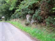
Travelling South along the A916 just past Craigrothie, turn right down to Chance Inn, and turn left at the T junction. and follow the road on to just past the left hand bend when Waltonhill Farm will be seen on the right. Continue south down the road a few hundred yards until it takes a slight right turn. The De’il’s Stane, a huge flat faced slab of rock, will be seen at the roadside on the left side of the road, partly obscured by gorse.

Archaeology & History

According to a piece published in the Fife Herald & Journal in 1905:-

“Once upon a time, so runs the legend, Samson challenged the devil to match him at boulder throwing. As challenger, Samson stood on the West Lomond; Satan stood on the East. The signal was given; two mighty rocks whistled through the air. ‘The De’ils Stane’ fell where it now lies, on the road-side about a quarter of a mile west [sic] from Waltonhill Farm. Samson, though handicapped by three miles greater distance, flung his stone fully four hundred yards beyond that of Satan, and with such force that it split into three parts; which parts are now built into Waltonhill barn”.

The roadside location, just south of the bend

The De’il’s Stane, a huge slab of rock!

This is of course a variant of a creation myth that is to be found throughout Britain, of an Age of Giants who hurled rocks around and strode the land quarrelling with each other and the mortal humans . The original names of the Waltonhill Giants have been lost in the aeons of oral transmission of the legend from pre-history, and replaced by that of a probably equally legendary Middle Eastern strong man from the Christian’s Bible, in combat with the Christian’s Naughty Man. And this was of course done to prove the point of Christianity’s superiority over the old animistic cults of the land, and the De’il had to be demonstrably the loser.

De’ils Stane thrown by the Man in the Red Velvet Suit from East Lomond (Left)

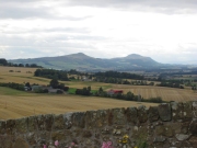
Owing to the Stone being partly hidden by gorse, it was not possible to make a close inspection of the rock for carvings etc. A further visit will no doubt be made to try to clear some of the gorse so a closer inspection can be made. The Stone’s size (approximately 15′ high by 20′ wide by 4′ thick) and the way it is resting against a natural bank, does give a credence to the legend of its having been slung by a giant from East Lomond, clearly visible nearly 7¾ miles away.

Reference:

  1. Fife Herald & Journal, 1st November 1905, quoted in John Ewart Simpkins’ County Folklore – Volume VII: Fife, with some notes concerning Clackmannan and Kinross-shires, Folk-Lore Society by Sidgwick& Jackson: London 1914.

© Paul T. Hornby, The Northern Antiquarian 2018

Kalemouth Carving, Eckford, Roxburghshire

Cup-and-Ring Stone:  OS Grid Reference – NT 714 275

Archaeology & History

Kalemouth carving (after R.W.B. Morris 1981)

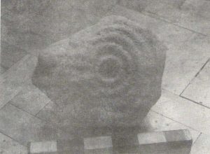
Now housed in the National Museum of Antiquities in Edinburgh, this little-known petroglyph was rediscovered in 1957 by a Mr G.F. Ritchie, not far from the once-large Kalemouth neolithic tomb.  It’s a carving that seems to be quite isolated (no others are known about in the immediate area), comprising of an incomplete four-ringed design which, in all probability, is a stray rock that came out of a nearby prehistoric cairn—although we don’t know this for sure.

The carving was described in Ron Morris’ (1981) petroglyph survey, where he told us that,

“In the field “not far from the cairn” (just E of the farm), was a small convex gritstone boulder 25cm by 15cm by 15cm (¾ft  x ½ft x ½ft). On its fairly smooth surface is:

a cup-and-four-rings with 2 parallel grooves from the inner ring (which is incomplete) through the others (which are gapped)—the outer two being now incomplete also—a form of ‘keyhole pattern’.”

A near-identical carving on a similiar-shaped portable stone can be seen in Galashiels museum, whose history has seemingly been forgotten.

References:

  1. Morris, Ronald W.B., “The cup-and-ring marks and similar sculptures of Scotland: a survey of the southern Counties – part 2,” in Proceedings of the Society of Antiquaries, Scotland, volume 100, 1967.
  2. Morris, Ronald W.B., “The Cup-and-Ring and Similar Early Sculptures of Scotland; Part 2 – The Rest of Scotland except Kintyre,” in Transactions of the Ancient Monuments Society, volume 16, 1969.
  3. Morris, Ronald W.B., The Prehistoric Rock Art of Southern Scotland, BAR: Oxford 1981.

© Paul BennettThe Northern Antiquarian

Heygate Stone, Baildon, West Yorkshire

Cup-and-Ring Stone:  OS Grid Reference – SE 15942 40187

Archaeology & History

Heygate Stone

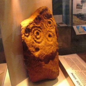
This excellent cup-and-ring marked petroglyph was found fortuitously in September 2001 by the land-owner at Near Hey Gate field to the northeast of Baildon village.  He was clearing out remains of some old walling in the field and, adjacent, a rock that was protruding out of the ground got turned over.  Underneath it he noticed a series of very well-preserved cups and rings in a cluster near one part of the rock.  It was a bittova beauty to be honest!

Thankfully due to the subsequent efforts of local rock art students Mike Short and Keith Boughey, it was later re-housed in the Brackenhall Centre at the edge of Shipley Glen.

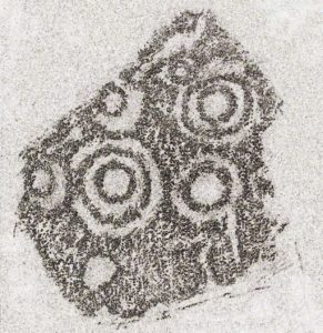
Enhanced rendition of Keith Boughey’s Heygate Stone rubbing
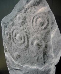
Computer-enhanced image of the carving

The stone itself was once larger than it now is and may have had additional carved elements on it, but the other portion that had broken off wasn’t located when it was first dug out of the ground.  This may mean that it was moved here from another location, which would have been somewhere close by.  Many other petroglyphs exist in and around the Baildon district.As we can see in the images here, two very well-defined double cup-and rings have clusters of smaller singular cup-and-rings around their edges.  A single cup-mark was etched below the largest of the double-ring carving, and what seems like a carved straight line emerges from the largest of the single cup-and-ring.

References:

  1. Griffiths, Kathie, “Historic Stone Back Home on Moors,” in Telegraph & Argus, 11 November, 2006.
  2. Short, Mike, “The Heygate Stone,” on Megalithic Portal, 21 November, 2006.

Acknowledgements:  Big thanks to Mike Short for his info and to Keith Boughey whose rubbing I’ve touched-up and used in the site profile.

© Paul BennettThe Northern Antiquarian

Holy Well, Baildon, West Yorkshire

Holy Well (destroyed):  OS Grid Reference – SE 1609 3961

Archaeology & History

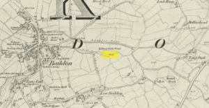
This site is all but unknown to the great majority of folk in Baildon, and even some of the local historians have let it slip from their investigative tendrils.  According to the primary Baildon historian, W.Paley Baildon, it was first known as the ‘Halliwell Holy Well’.  In his magnum opus (1913-26) of the township he relates that,

“The 1852 Ordnance map marks Halliway Banks Wood to the south of Langley Lane, with a well just below it, and a footpath from Holden Lane to the well.  Halliway, I think, is a corruption of Halliwell, the ‘holy well,’ with the special footpath leading to it and nowhere else.  Haliwell Bank occurs in (the Baildon Court Rolls of) 1490, when it formed part of the property held by William Tong of Nicolas Fitz William.”

This etymology is echoed by the great place-name authority A.H. Smith (1954).  It also caught the attention of archaeologist Andrea Smith (1982), in her investigation of twenty-five holy wells in the West Yorkshire region.

“Many wells,” she wrote, “are recorded simply as ‘Holy Well,’ or the various forms ‘Halliwell,’ ‘Helliwell’ and ‘Hollowell.’  It is possible that in these instances the identity of the patron saint or guardian of the well has been forgotten, which may be the case with the site at Collingham, now known as Hollowell.”

Site of the Holy Well in 1852

The well itself can no longer be seen.  When I looked for the site in 1982, I found that to the right of where the 1852 map showed it, was a waterworks lid covering the old holy waters, just in the trees atop of the field beneath a great sycamore with a number of small stones roughly encircling the site: perhaps the only possible relics of the century before when the waters would have been used.  A stone trough was situated at the bottom of Holden Lane, fed by the waters from the Halliwell and from here the course of the stream meandered down the side of Slaughter Lane, now known as Kirklands Road.  The land around Halliwell became known as Kirkfield, or field of worship.

A local resident told how during autumn and winter, the left side of the field gets extremely boggy – the region were the old stream ran from the old well, along which dowsers have found aquastats abound.  Now however, houses have been built where the waterworks-lid used to be and is likely to be in someone’s backyard, all but forgotten.

Folklore

According to local lore, the site of this most ancient of holy wells was found in the warmest place in the Baildon district.  Whilst its geographical position doesn’t necessarily suggest this (although it did face south, into the sun), this lore may reflect some healing aspect of the well that has long since been forgotten.

Perhaps relevant to Andrea Smith’s comment about there being ‘guardians’ at holy wells is found in folklore relating to nearby Holden Lane: locals in the last century also referred to it as Boggart Lane, so called after the Boggart which was seen there in the form of a spectral hound that was said to possess large glowing red eyes and was a sign of ill omen.  Modern sightings of the spectral hound, which appeared along the road which led to the old well, are unknown.

References:

  1. Baildon, W. Paley, Baildon and the Baildons (parts 1-15), St. Catherines: Adelphi 1913-26.
  2. Smith, A.H., English Place-Name Elements – volume 1, Cambridge University Press 1954.
  3. Smith, Andrea, ‘Holy Wells Around Leeds, Bradford & Pontefract,’ in Wakefield Historical Journal 9, 1982.

© Paul BennettThe Northern Antiquarian

Holy Well, Barking, Essex

Holy Well (destroyed):  OS Grid Reference – TQ 4421 8484

Archaeology & History

Barely 200 yards to the immediate southeastern edge of the once gigantic hillfort of Uphall Camp, could once be found an old holy well, last recorded it would seem in 1456.  The site was located just yards to the south of the old boundary that separates the parishes of Ilford and Dagenham.  Its location was described in the Victoria County History:

“A mile south of Ilford Bridge the Roding is joined by Loxford Water, a stream rising near Hog Hill, in Dagenham, and known in its upper reaches as Seven Kings Water. In 1456 the lower part of the stream was called Halywellbrooke.”

We also have an account in the Barking Abbey Rental, which told us there was “land in Longland at Halywellbrooke”, as well as “pasture lying at the northern head of Luzias land…near Halywell and…at Loxfordbrigge.” (Harte 2008)  It has long since been destroyed.

References:

  1. Harte, Jeremy, English Holy Wells – volume 2, Heart of Albion Press: Marlborough 2008.
  2. Powell, W.R. (ed.), A Victoria County History of Essex – volume 5, OUP: London 1966.

LinksHoly Well, Barking on The Megalithic Portal


Cloven Hoof Well, Shipley Glen, West Yorkshire

Sacred Well:  OS Grid Reference – SE 12839 39331

Also Known as:

  1. Raygate Well

Getting Here

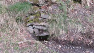
Cloven Hoof Well, Shipley Glen

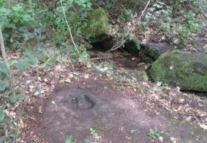
On the roadside at Shipley Glen, from Brackenhall Circle walk up for about 250 yards, where you’ll notice the land dips as it drops into the woods below. Follow this dried stream down until you reach the mossy Loadpit Beck in the valley.  By the waterside is a footpath: follow this upstream for a short distance, keeping your eyes peeled on the Earth below where a smaller stream crosses the path you’re walking on.  Follow this uphill to its source!

Archaeology & History

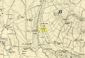
Halfway up (or down) the moss-covered waters of Shipley Glen the all-but-forgotten waters of the Cloven Hoof Well still flows nice and freely, and is still good to drink. It was shown on the first OS-map of the area in 1852, where it was called the Raygate Well, whose derivation neither the great Baildon historian W. Paley Baildon nor the place-name giant A.H. Smith could account for.  It sounds just like it was someone’s surname, but local genealogy cannot affirm this.  One possibility—and which reflects in the local lore of the site—is that it’s a compound word from the old northern dialect word Rea, “an evil spirit or demon”, and gate, “a hole, an opening or gap.”  The terms are used in a prayer given in Mr Sinclair’s Satan’s Invisible World Displayed (1814),

“as recited in the time of Popery by persons when going to bed, as a means of them being preserved from danger:

“Keep this house from the weir…
And from an ill Rea,
That be the gate can gae.””

But this purely speculative….

Cloven Hoof Well on 1852 map

A photograph and brief description of the Cloven Hoof Well was given in an early edition of the Bradford Scientific Journal after a geological excursion to Shipley, though nothing was said of its curious name. However on a rock below the spring, a hoof-print mark is clearly seen.  It appears to be part-natural and partly enhanced.  This is an area rich in prehistoric petroglyphs, or cup and rings stones.

Mosses thankfully still cover the rocks from whence the waters flow; and bilberry, blackberry, male fern and bracken also grow around it.  Psychoactive plants also abound nearby. The water is healthy and never seems to dry up, even during long warm summers.  And below here, on the other side of the stream at the bottom, you can visit the little-known Wood Well

Folklore

Local lore told that the devil stepped here and left his hoof-mark in the rock, making the waters rise from the Earth.  Possibly a venerated site in earlier days, one finds numerous ancient remains nearby (cup and rings, stone circle, walling, cairn fields).  Pagans amongst you should love this place!

References:

  1. Armitage, Paul, The Holy Wells and Healing Springs of West Yorkshire, forthcoming
  2. Baildon, W. Paley, Baildon and the Baildons (parts 1-15), St. Catherines: Adelphi 1913-26.
  3. la Page, John, The Story of Baildon, William Byles: London 1951.

© Paul BennettThe Northern Antiquarian

Mineral Well, Glen Lyon, Perthshire

Healing Well:  OS Grid Reference – NN 72110 47768

Also Known as:

  1. Iron Well

Getting Here

Mineral Well, Glen Lyon

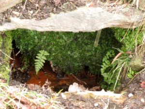
From Fortingall village, head west and turn down into the incredible beauty that is Glen Lyon.  As you enter the trees, a half-mile along you pass the small gorge of MacGregor’s Leap in the river below.  2-300 yards pass this, keep your eyes peeled for an old small overgrown walled structure on the left-hand side of the road, barely above the road itself.  A large tree grows up above the tiny walled enclosure, within which are the unclear waters that trickle gently….

Archaeology & History

In previous centuries, this all-but-forgotten spring of water wasn’t just a medicinal spring, but was one of the countless sites where sympathetic magick was practised.  The old Highlanders would have had a name for the spirit residing at these waters, but it seems to have been lost.  The site is described in Alexander Stewart’s (1928) magnum opus on this stunning glen, where he wrote:

“Still a few yards more and Glenlyon’s famous mineral wishing well is seen gushing up, surrounded by its wall of rough stones now sadly in need of repair.  It has a stone shelf to receive the offerings of those who still retain a trace of superstition or like to uphold old customs as they partake of its waters.  The offerings usually consist of small pebbles, but occasionally something more valuable is found among them. The roadmen may clear that shelf as often as they like, but it is seldom empty for long.”

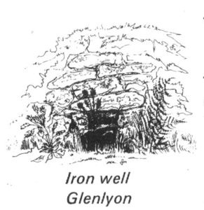
A local lady from Killin told us that she remembers the stone above the well still having offerings left on it 20-30 years ago. Hilary Wheater (1981) sketched it and called it the Iron Well.

Close-up of the waters (photo by Paul Hornby)
Hilary Wheater’s sketch

The waters in this small roadside well-house actually emerge some 50 yards up the steep hillside (recently deforested) and in parts have that distinct oily surface that typifies chalybeates, or iron-bearing springs – which this site is an example of.  Its medicinal properties would help to people with anaemia; to heal women just after childbirth; to aid those who’d been injured and lost blood; as well as to fortify the blood and stimulate the system.

Across the road from the well, Stewart (1928) told of a giant lime tree that was long known to be the meeting place for lovers (perhaps relating to the well?), and the name of the River Lyon here is the Poll-a-Chlaidheamh, or ‘the pool of the sword’, whose history and folklore fell prey to the ethnic cleansing of the english.

References:

  1. Stewart, Alexander, A Highland Parish, Alexander Maclaren: Glasgow 1928.
  2. Wheater, Hilary, Aberfeldy to Glenlyon, Appin Publications: Aberfeldy 1981.

© Paul BennettThe Northern Antiquarian