Craig Hill cluster (5), Kenmore, Perthshire

Cup-and-Ring Stone:  OS Grid Reference – NN 81305 44422
Getting Here

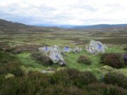
Craig hill cluster (5) stone

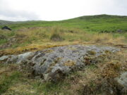
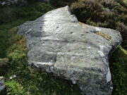
From Kenmore go east up the steep mountain road towards Glen Quaich, or if you’re coming from Amulree, go west along the same glen.  After 2½ miles (4km) up the Kenmore route (nearly 9 miles on the Amulree route) you’ll reach a small lochan on your left (you’ve got a very small parking spot a coupla hundred yards before the loch).  A gate and stile past the loch takes you east along a track into the moors.  More than a mile on, the track splits, but you need to keep to the left and follow the track along the wall-side for another 400 yards or so, where you’ll see a small crag of rocks 100 yards down the slope on your right. Once here, the deformed triangle-shaped stone to the left-side of the cluster is the one you’re looking for.

Archaeology & History

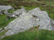
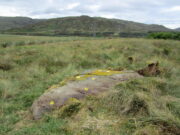
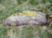
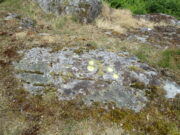
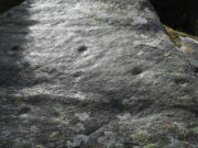
About four yards west of the Craig Hill cluster (3) carving, this gently smooth sloping rock was initially noted to have between six and seven cup-marks on it.  Under the grey skies it was difficult to see any of this clearly, and so we wet the surface when Nature gave us some short bursts of light through the clouds which then enabled us to get a much better look at the design—but it’s still far from clear.
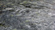
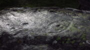
Curious eye motif
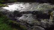
Central elements of carving

We found at least eight cups on here, two of which had single rings: the one near the top of the stone seems to be complete, whilst the other nearest the bottom of the stone looks to be incomplete.  Another cup had a curious double ring; whilst the one nearest the middle of the stone has what may be three rings, with what could be a carved line running from its centre—but it’s very difficult to say with certainty until we’ve made another visit.  I have little doubt that there’s more to this petroglyph than we could make out beneath the grey skies.  On the west-side of the stone, the “curious” double-ring has, as its outer surround, an “eye” motif, or lozenge, which is also found on the Craig Hill cluster (3)  stone a few steps away.  The eye motif on both stones have the same levels of erosion and, I would suggest, were carved within a century or two of each other; perhaps even around the same time.

This one’s well worth checking out!

Acknowledgements:  Huge thanks to Prof Paul Hornby for use of his photos in this site profile; and to Myrna Hurley for getting us up there.  Cheers doods. 😉

© Paul BennettThe Northern Antiquarian

Craig Hill cluster (3), Kenmore, Perthshire

Cup-and-Ring Stone:  OS Grid Reference – NN 81307 44419

Getting Here

Craig Hill petroglyph cluster

From Kenmore go east up the steep mountain road towards Glen Quaich, or if you’re coming from Amulree, go west along the same glen.  After 2½ miles (4km) up the Kenmore route (nearly 9 miles on the Amulree route) you’ll reach a small lochan on your left (you’ve got a very small parking spot a coupla hundred yards before the loch).  A gate and stile past the loch takes you east along a track into the moors.  More than a mile on, the track splits, but you need to keep to the left and follow the track along the wallside for another 400 yards or so, where you’ll see a small crag of rocks 100 yards down the slope on your right. That’s your target!

Archaeology & History

The stone in question

One of at least six rocks next to each other that possess cup-and-rings, this is the most notable of the bunch inasmuch as it’s the one that stands out above all the others.  At first sight it doesn’t look impressive: a shallow scatter of nine or ten cup-marks can be seen when the light’s alright, but that’s about it.  This is what George Currie (2005) noticed when he first came across it in 2004, describing it simply as “a boulder with 10 cups” a few yards away from one of it’s fellow petroglyphs (CR19, or the Craig Hill cluster-2 carving).  But there’s much more to it than that.  Unfortunately when we visited here, we weren’t blessed with good daylight, so were unable to get a decent appraisal of the entire design and have most probably missed some elements.

Curious double-ringed eye
General overview of design

On the top sloping surface are  six or seven cup-marks; another two or three are on a secondary lower level of the stone.  Of those on the top, at least two of them have surrounding rings: one with a carved line coming out to the southeast; the other having a more extravagent appearance, surrounded by what looks like a secondary outer “oval”, or eye-shaped design.  It’s ununsual.  Other lines intersect these cup-and-rings, but it was difficult to say with any certainty whether they were Nature’s handiwork, or had been modified by humans.  Below these on a slightly lower level are two or three single cup-marks, one of which, close to the edge of the rock, appears to have an incomplete ring round it—but this might have just been a trick of the light.  Another visit is required for a better appraisal…

References:

  1. Currie, George, “Craig Hill (Dull parish): Cup-and-Ring Marked Rocks,”in Discovery & Excavation Scotland, NS Volume 6, 2005.

Acknowledgements:  Huge thanks to Prof Paul Hornby for use of his photos in this site profile; and to Myrna Hurley for getting us up there.  Cheers doods. 😉

© Paul BennettThe Northern Antiquarian

Balgay Hill, Dundee, Angus

Cup-and-Ring Stone (removed):  OS Grid Reference – NO 378 308

Archaeology & History

Cup & ring stone of Balgay Hill

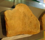
This little-known cup-and ring stone was found at ground level sometime around 2003, near the top of Balgay Hill.  A small portable stone that may have been broken from a larger slab, it has what seems to be two if not three cup-and-rings, accompanied by two or three single cup-marks.  One of the rings seems to have a faint line coming out of it.  Unfortunately none of this is clear in the photos I took (the one attached here is the best), as it lives under glass in Dundee Museum, so it was very difficult to get decent images.  It is now housed in the McManus Museum in Dundee (a damn good place, with very helpful staff) and well worth checking out if you’re in the area.

© Paul BennettThe Northern Antiquarian

Finavon, Oathlaw, Angus

Cup-and-Ring Stone (removed):  OS Grid Reference – NO 5061 5565

Archaeology & History

Finavon carving, now in Dundee Museum

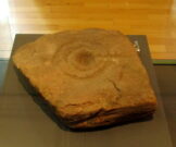
Close to the western walls of the Finavon Iron Age hillfort this small (portable?) cup-and-ring stone was found at ground level in 1987.  It was probably knowingly reused in the construction of the hillfort, but whether it was just deemed as an innocuous carving thrown into the mass, or whether it held a place of importance cannot be known.

The primary design consists of a cupmark surrounded by a double-ring, with a line coming out of the central cup towards the edge of the stone.  The stone itself—measuring 12 inch by around 10 inch—has been cut from a larger piece, meaning the original design may have been larger.  It is now housed in the McManus Museum in Dundee (a damn good place, with very helpful staff).

References:

  1. Sherriff, John, “Prehistoric Rock-Carving in Angus,” in Tayside & Fife Archaeological Journal, volume 1, 1995.
  2. Zealand, A., “Fanavon (Oathlaw Parish): Cup-and-Ring Stone,” in Discovery Excavation Scotland, CSA: Edinburgh 1988.

© Paul BennettThe Northern Antiquarian

Beauly Avenue, Downfield, Dundee, Angus

Cup-Marked Stone (lost):  OS Grid Reference – NO 3975 3340

Also Known as:

  1. Magdalen’s Kirkton Stone

Archaeology & History

In the mid-1890s, workmen ploughing one of the fields near the steading at Magdalen’s Kirkton farm hit a large stone beneath the soil.  It turned out to be the covering stone of a prehistoric burial, or cist, that was aligned east-west.  Whilst the remains in the cist had all but turned to dust, the covering stone had a number of cupmarks on it.  It was described only briefly by R.N. Kerr (1896), who told that,

“The stone forming the lid of the cist is cup-marked.  It weighs 5 cwt., 1 qr., 21½ lbs., and its thickness varies from 9 to 12 inches.  There are 40 or more cup-markings on it, varying from 1 to 3 inches in diameter.”

It would seem that no sketches were made of this carving and I’ve been unable to find any more details about it. Help!

References:

  1. Kerr, R. N., “Notice of a Burial Cist found on the Farm of Magdalen’s, Kirkton, on the Estate of Balmuir, near Dundee,” in Proceedings Society Antiquaries, Scotland, vol. 30, 1896.

© Paul BennettThe Northern Antiquarian

Corrymuckloch (14), Amulree, Perthshire

Cup-Marked Stone:  OS Grid Reference – NN 89253 35346

Getting Here

Looking to the SE

Take the A822 road to the northeast of Crieff and head 4-5 miles along until you enter the Sma’ Glen.  You go past Ossian’s Stone and after crossing the river the road starts to go uphill.  Nearly 2 miles up, the road levels out and at the left-side of the road is a small thin car-parking spot. Keep your eyes truly peeled for that!  Go through the gate and turn right (north), up the grassy slope.  Follow this footpath (known as General Wade’s road) straight past Corrymuckloch Farm until, about 250 yards on, the track splits.  Take the left track and nearly 500 yards along walk up the embankment on your left and look around (if you reach the gate you’ve gone too far).

Archaeology & History

Corrymuckloch (14) stone

This stone was rediscovered in July 2023 during a cursory survey of other carvings in the Corrymuckloch cluster (17 and counting!).  Most of the stone was covered in vegetation when first found, with just a single cupmark near its crown ensuring it got more attention.  Altogether there are 10 or 11 cup-marks of varying levels of erosion across the length and breadth of the rock.  The most notable one is on the northwest side of the stone, it being twice the size of the others and of much greater depth.  It may originally have been a natural depression that was enhanced when the stone was carved.  This larger cup has a smaller one attached just above it.

An intriguing find was noted all along the western edge of the rock, where upwards of a hundred small pieces of quartz—the majority of it crystal clear—were scattered between the stone edge and the soil.  This is  an ingredient that’s been noted at a number of petroglyphs in Scotland.

© Paul BennettThe Northern Antiquarian

Corrymuckloch (2), Amulree, Perthshire

Cup-Marked Stone:  OS Grid Reference – NN 89037 34706

Getting Here

Corrymuckloch (2) stone

Take the A822 road to the northeast of Crieff and head 4-5 miles along until you enter the Sma’ Glen.  You go past Ossian’s Stone and after crossing the river the road starts to go uphill.  Nearly 2 miles up, the road levels out and at the left-side of the road is a small thin car-parking spot. Keep your eyes truly peeled for that! Walk through the gate and along the track (west) for 300 yards until you reach the fence.  Once here, walk right (north) and go through the gate less than 50 yards away.  Less than 300 yards ahead of you you’ll see a small rock outcrop.  Get to it!

Archaeology & History

Rediscovered in July 2023, on this small rock outcrop it seems that only the lower east section has been carved, and it can be pretty difficult to see beneath the old layers of lichen that’s been painted across its surface.  Comprising of just four cup-marks close to each other on the top of the stone, there’s a possible fifth cup to be seen on its northeast length.  It’s nowt special to look at to be honest, but it’s worth checking out when you’re looking at the others in this cluster.  In truth, this is another that’s only gonna be of interest to the real geeks amongst you!

© Paul BennettThe Northern Antiquarian

Organn Well, Pontefract, West Yorkshire

Healing Well (destroyed):  OS Grid Reference – SE 45 21

Archaeology & History

The waters of the once-renowned Organn Well goes down in history as being one of the first wells in Britain whose waters were used in a town pump.  Written minutes from an early council meeting described how people gathered in the market place to discuss the objective of making such a pump in the times of Queen Elizabeth 1, in 1571.  It was completed a year later and, some 450 years on, this old relic can still be seen.  The Well used to be found off Penny Lane (now Wakefield Road), some 4-500 yards to the southwest and as such it’s exact position has been difficult to locate.  But the fact that the waters were piped such a distance strongly suggests that the water supply from the Well was damn good – and most probably damn refreshing too!  The old charter told us, in that wonderfully dyslexic manner of the period,

…that a conduit in the Markett Place with lead pipes leading to water from Organ Well to the said conduit shall bee cleansed and repayred at the charge and contribution of severall inhabitants of the Towne and espetially by those that fetch water from the same conduit. And according to the auncient custome of the said Towne, whoe shall not beare theire p’t of the chardge p’portionable to what water they from the same at the discretion of the Majo’ for the time being and his brethren shall be debarred from the benefitt of the said conduit except they shall be poore people.  And likewise that none shall receive any water from the said conduite for to brewe or steep barley w’thall at such time or times as others have need the same for meat water and water to washe w’hall, but onely at such times as there is water to spare over and besides what is convenient for meat and washing.”

More than two hundred years later the water pump was in dire need of attention, as George Fox (1827) told:

“Being in a ruinous state about the year 1810 and the supplies of water being insufficient for the public use; a clause was inserted in the act of parliament… wherein the pump, its pipes, and all other appurtenances belonging to it were vested in the power of the commissioners of the streets, who where bound to see it kept in proper repair.”

And so the water from the Organn Well continued to supply the townsfolk.

The etymology of this well—along with another of the same name near Harrogate—truly puzzled me for a long time; that was until I came across, quite by accident, records from early texts on herbalism.  As a result, it seems very likely that it derives its name from the old English ‘organe,’ which, according to Stracke (1974) and others relates to both varieties of the indigenous herb marjoram (Origanum vulgare and O.marjorana) — a grand medicinal plant that’s pretty common in northern England (I used to go out gathering it each year in my younger days).  There were obviously profuse supplies of this herb growing in and around the well and, as all good herbalists will tell you, when they grow by an old spring or well, their medicinal properties are much better than normal.  The waters and the plant obviously had a good symbiosis; or, as the old women who’d collect the waters and the herbs in days prior to the pump would have told us, “the spirits of the water here are good”…

References:

    1. Fox, George, The History of Pontefract in Yorkshire, J.Fox: Pontefract 1827.
    2. Padgett, Lorenzo, Chronicles of Old Pontefract, Oswald Homes: Pontefract 1905.
    3. Stracke, J. Richard (ed.), The Laud Herbal Glossary, Rodopi: Amsterdam 1974.

© Paul BennettThe Northern Antiquarian

Briery Wood, Ilkley, West Yorkshire

Cup-and-Ring Stone (lost):  OS Grid Reference – SE 0965 4797

Archaeology & History

In Ronald Morris’ (1989) gazetteer of British petroglyphs, he included this curious entry but gave no real details regarding its appearance or history.  Listed by the Royal Commission lads, it would seem to have been located immediately south of the dismantled railway where it used to cross the Addingham-Ilkley road, but no one seems to have seen it either before or since Morris’ description.  Any help regarding its whereabouts would be appreciated.

References:

  1. Boughey, Keith & Vickerman, E.A., Prehistoric Rock Art of the West Riding, WYAS: Wakefield 2003.
  2. Morris, Ronald W.B., “The Prehistoric Rock Art of Great Britain: A Survey of All Sites Bearing Motifs more Complex than Simple Cup-marks,” in Proceedings of the Prehistoric Society, volume 55, 1989.

© Paul BennettThe Northern Antiquarian

St. Helen’s Well, Hartlepool, Durham

Holy Well (destroyed):  OS Grid Reference – NZ 5236 3421

Also Known as:

  1. Freemen’s Well

Archaeology & History

Highlighted on the 1861 OS-map of the area, there is a curious lack of reference to this holy well until Cuthbert Sharp wrote about it in 1816.  Records of an adjacent St. Helen’s Chapel are in plentiful supply, going all the way back to around 1200 CE—although it’s pretty obvious that a water supply would be attached to the chapel, despite its late literary account.   Sharp told us:

“This chapel is stated to have been on the warren.  According to local tradition, a church once stood near the Freemen’s or St. Helen’s Well, in the Far-well Field, where the ground at present is considerably elevated, and where many hewn stones are constantly discovered, which renders it highly probable that this was the site of the chapel in question.”

Site shown on 1861 OS map
Site on the 1862 Town plan

When Robert Surtees visited here in 1823, the well was still visible, but remains of the chapel were negligible.  On the 1862 Hartlepool Town map, it would seem that a construction—perhaps a well-house—covered the waters, although whatever it may have been seems to have been destroyed sometime in the 1880s, when the entire area was built over.  No remains of this sacred site have been seen since.

References:

  1. Cuthbert Sharp, A History of Hartlepool, Francis Humble: Durham 1816.
  2. Surtees, Robert, The History and Antiquities of the County Palatine of Durham (4 volumes), London 1816-40.

Acknowledgements:  The map accompanying this site profile is Reproduced with the kind permission of the National Library of Scotland

© Paul BennettThe Northern Antiquarian