Bishop’s Well, Dunblane, Stirlingshire

Holy Well (destroyed):  OS Grid Reference – NN 78126 01281

Also Known as:

  1. Canmore ID 24681

Archaeology & History

Bishop’s Well on 1899 map

This now-lost holy well was a place whose history was integrally tied to the adjacent and also destroyed Bishop’s Palace: a large ostentatious building that was already in ruins in 1579, just below Dunblane Cathedral. It was the water supply for the bishops who lived here; although exactly when it received its original dedication, and by whom, seems unknown.

The best description we have of it is in Alex Barty’s (1944) excellent history work on Dunblane, where he wrote:

“Perhaps the best-known well in Dunblane was the Bishop’s Well, in the Bishop’s Yard or Grassyard.  This well is now dry and the explanation is that it was fed by a strong stream from about Kirk Street which was incorporated into the town sewer when it was laid in Kirk Street.  There was a right-of-way, or at least a  privilege, held by some of the inhabitants to pass through the north end of the Manse ground out by a gate which still exists and down a path to the well.”

Mr Barty informed us that the line of the footpath was still visible in his day, but it has long since gone.  When Archie McKerrarcher (1992) wrote about the site, he described minor remains of it still extant, telling that “the Bishop’s Well can be seen marked by circular stonework in the grass”; but this has now also been destroyed.  One would think that the local christian community would at least have tried to preserve this ancient site.

References:

  1. Barty, Alexander B., The History of Dunblane, Eneas Mackay: Stirling 1944.
  2. Dennison, E.P. & Coleman, R., Historic Dunblane: The Archaeological Implications of Development, RCAHMS: Edinburgh 1997.
  3. McKerracher, Archie, The Street and Place-Names of Dunblane and District, Stirling District Libraries 1991.

Acknowledgements:  To Paul Hornby in his help seeking out this site; and to the staff at Dunblane Library.

© Paul BennettThe Northern Antiquarian

The map could not be loaded. Please contact the site owner.


Kipps, Linlithgow, West Lothian

Stone Circle (destroyed):  OS Grid Reference – NS 9909 7387

Also Known as:

  1. Canmore ID 47920

Archaeology & History

Site shown on 1856 map

In an Address to the Scottish Society of Antiquaries in the middle of the 19th century, Sir James Simpson (1862) pointed out the outright destruction and vandalism that incoming land-owners (english mainly, and probably christians too) had inflicted on the monuments of the Scottish people.  Stone circles and two cromlechs, he said, that had existed in this part of West Lothian for thousands of years, were recently destroyed when Simpson was alive.  One of them was here at Kipps.  He told:

“In 1813 the cromlech at Kipps was seen by Sir John Dalzell, still standing upright.  In describing it, in the beginning of the last century, Sir Bobert Sibbald states that near this Kipps cromlech was a circle of stones, with a large stone or two in the middle; and he adds, “many such may be seen all over the country.”  They have all disappeared; and latterly the stones of the Kipps circle have been themselves removed and broken up, to build, apparently, some neighbouring field-walls, though there was abundance of stones in the vicinity equally well suited for the purpose.”

Simpson suggested, quite rightly, that efforts should be made to resurrect the old monument.  In his day the fallen remnants of the ‘cromlech’ that had stood inside the circle were still in evidence and it was highlighted on the early OS-map of the region; and when the northern antiquarian Ratcliffe Barnett (1925) came walking here earlier in the 20th century he told he could still see “the remains of an ancient cromlech, which stood within a circle of stones.”  Around the same time, the Royal Commission (1929) lads looked for these remains but seemed to have gone to the wrong site, “a quarter-mile northwest of Kipps Farm”, where they nevertheless found,

“a tumbled mass of boulders containing about thirty stones, one being erect; they vary from 6 by 3 by 1½ feet by 4 by 3 by 2½ feet, and are probably the remains of a cairn.”

When the renowned chambered tomb explorer Audrey Henshall (1972) followed up the directions of the Royal Commission, she was sceptical of giving any prehistoric provenance to the rocks there, describing them simply as geological “erratics.”

The very place-names Kipps may derive from the monument, for as Angus MacDonald (1941) told, “the word seems to come from Gaelic caep, ‘a block’”, but the word can also mean “a sharp-pointing hill, a jutting point, or crag on a hill”, and as the house and castle at Kipps is on an outlying spur, this could be its meaning.

Folklore

Local lore told how lads and lassies would use the stones as a site to promise matrimony with each other, by clasping their hands through a gap on the top boulder.  Using holes in or between stones to make matrimonial bonds, where the stone is the witness to the ceremony, occurs at many other sites and became outlawed by the incoming christian cult, which took people away from the spirits of rock, waters and land.

References:

  1. Barnett T. Ratcliffe, Border By-Ways & Lothian Lore, John Grant: Edinburgh 1925.
  2. Duns, J., “Notes on a Burial Mound at Torphichen, and an Urn found near the ‘Cromlech’ at Kipps, Linlithgowshire”,  in Proceedings of the Society of Antiquaries, Scotland, volume 12, 1878.
  3. Henshall, Audrey S., The Chambered Tombs of Scotland – volume 2, Edinburgh University Press 1972.
  4. Lewis, A.L., “The Stone Circles of Scotland,” in Journal Anthropological Society Great Britain, volume 30, 1900.
  5. MacDonald, Angus, The Place-Names of West Lothian, Oliver & Boyd: Edinburgh 1941.
  6. Royal Commission on the Ancient & Historical Monuments, Scotland, Midlothian and Westlothian, HMSO: Edinburgh 1929.
  7. Simpson, James Y., “Address on Archaeology,” in Proceedings Society of Antiquaries, Scotland, volume 4, 1862.

Acknowledgements:  Accreditation of early OS-map usage, reproduced with the permission of the National Library of Scotland.

© Paul BennettThe Northern Antiquarian

The map could not be loaded. Please contact the site owner.


Gormyre, Torphichen, West Lothian

Standing Stone (destroyed):  OS Grid Reference – NS 9836 7315

Also Known as:

  1. Canmore ID 47916

Archaeology & History

A couple of fields east of one of Torphichen’s Refuge Stones (a prehistoric thing by the look of it!), another standing stone could once be seen.  It wasn’t a particularly big fella, and its existence may have completely fallen out of history were it not for the Scottish Royal Commission (1929) lads who visited and described the place thus:

“In the fourth field north-east of Gormyre Farm is a narrow, upright, pointed boulder of schist, 3 feet 10 inches high and 1 foot 6 inches wide at base, which is roughly pentagonal.  The greatest width on the east face is 20 inches, on the west face 8 inches; but the faces die into each other at the upper part till the section becomes triangular.”

A few years after the Royal Commission boys had been here, the land-owner saw fit to uproot the stone and dump it at the side of the field.  In the 1980s, when the Royal Commission lads came to visit the site again, they reported that the “standing stone no longer exists”—probably meaning that the land-owner had destroyed it.  Some idiotic land-owners do this sort of thing.

When we visited the arena a few weeks ago, Frank Mercer and I found a couple of stones at the side of the adjacent field which may have once stood upright, but if the early accounts of its position are correct, we were looking in the wrong place.  Another visit is required to see if we can find it in the undergrowth along the field edges.  If not, another one has bit the dust, as they say…

References:

  1. Mackay, P.H.R., Sanctuary and the Privilige of St. John, WLHAS: Edinburgh n.d. (1976?).
  2. Royal Commission Ancient & Historical Monuments Scotland, Inventory of Monuments & Constructions in the Counties of Midlothian and West Lothian, HMSO: Edinburgh 1929.

© Paul BennettThe Northern Antiquarian

The map could not be loaded. Please contact the site owner.


Three Stanes, Strathaven, Lanarkshire

Standing Stones (destroyed):  OS Grid Reference – NS 6957 4524

Archaeology & History

Threestanes on the 1864 OS-map

Threestanes on the 1864 OS-map

It seems that nothing remains of the three standing stones that gave rise to the place-name of Threestane Farm, at the top of Threestane Lane, on the northwestern outskirts of Strathaven.  We have no details on the size and form of the stones, nor when they were destroyed, but can presume that it was sometime prior to the Ordnance Survey lads coming here in 1858.

One local antiquarian, Maggie Overett, told that, “Slightly to the north east of Threestanes farm and near to the A726 Strathaven to East Kilbride road used to stand a farm called Westfield(still currently shown on my Google Earth) it was demolished over a year ago. Just behind what was the farm is a slight incline with what appears to be a standing stone. I have not been able to gain access to the site because of barriers put up by whoever owns the plot…… But it’s close enough to tie in the Threestanes estate…….and only a short distance from the known Strathaven Stane.”

Any further information about these lost monoliths would be greatly appreciated.

References:

  1. Bryson, J.M., Handbook to Strathaven and Vicinity, Townehead: Strathaven n.d.

© Paul BennettThe Northern Antiquarian

The map could not be loaded. Please contact the site owner.


Langside House, Cathcart, Glasgow, Lanarkshire

Cup-and-Ring Stone (removed):  OS Grid Reference – NS 5726 6128

Also Known as:

  1. Bluebell Woods
  2. Canmore ID 44291
  3. Langside Stone

Archaeology & History

In a region where, today, the busy city spreads its urban tendrils on the south-side of Glasgow, there could once be found an excellent multi-ringed prehistoric petroglyph.  It was located in the landscape of Langside and Battlefield, betwixt where now large houses grow, a few hundred yards south of the hillfort-topped Queen’s Park. According to the official records, it was all alone – but I don’t buy that for one minute! (petroglyphs rarely occur in isolation)

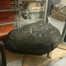
The carving in Kelvin Hall, Glasgow (photo by Donny McIntyre)
Langside House carving

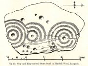
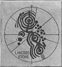
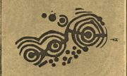
Before being noticed by archaeologists, the stone was apparently being used as a stone seat in the woods on which people would sit, rest and admire the view!  It was probably a part of a larger monument, perhaps a cairn of some sort.  As we can see in the sketches that were made of it, along with Donny’s photo of it (right) in the Glasgow Museum store-rooms, the stone was part of a larger piece and was likely to have had companions, but records seem to be silent on the matter.  The most detailed description of it comes from the pen of northern antiquarian Fred Coles (1906), who gave us the following literary portrait:

“The first notice of the Stone incised with the design shown below was due to Mr W. A. Donnelly, who contributed a description and a sketch to The Glasgow Evening Times of 25th June 1902.  Later, Mr Ludovic Mann, at my request, sent me certain notes he had taken of the cup-and-ring-marks.  But prior to this, the Stone itself had, on the instigation of Mr Donnelly, I think, been removed from its site in the wood, and placed near one of the entrances to the new Kelvinside Museum.  There I saw it and made measurements in July 1903.

“The Bluebell Wood lies in a curving line to the west and south of Langside House, and the cup-marked Stone was at a point in the southern extremity of the wood, above and north of the river Cart.  It is interesting to be able also to record that the longer axis of the Stone lay almost precisely north and South, and the opposite axis east and west.*  The Stone is of a hard, whitish sandstone, a good deal weathered and rounded at the edges. It measures 4 feet 9 inches in length and 3 feet 2 inches in breadth, and varies in thickness from 2 feet 6 inches to 1 foot 7 inches.  The striation of the Stone has helped to efface the cuttings which, though perfectly clear and measurable, are shallow in proportion to their width.  And this feature I have endeavoured to portray in the accompanying illustration (above).  Beginning at the north end of the Stone, there is one cup placed just where the outermost ring of that group touches the edge of the Stone.  The ring has a groove leading towards but not into a central cup, and four other cups are placed on the two outermost rings, there being four rings in this group.  The middle group consists of a central cup and three rings, flanked on the west by a row of three cups (one of which is the largest of all), and on the east by a double row of six cups, three of which are almost obliterated.  This middle group is imperfectly concentric, two of its arcs running into the fourth ring of the group on the south, which has a fine deeply picked central cup.  All the better-preserved rings are very nearly 1½ inches in width of cutting.

“The diameters of the outermost rings in each group are: of the north group, 1 foot 9 inches; of the middle group 1 foot 5 inches; and of the south group 1 foot 7 inches.  The cups vary in diameter from 3 inches to 1½.

“Considering the extremely easily weathered nature of this Stone, and the fact that its sculptured surface has already suffered much ill-usage, its present position, near the entrance of the Art Galleries, entirely unprotected by a railing and exposed to all sorts of abuse by casual passers-by as well as the weather, is not a fit and proper place for a Stone of such interest.”

A few years after this, the local historian Ludovic MacLellan Mann (1930) wrote a piece for the Glasgow Herald, in which he thought that both this and another carving in the area,

“commemorate chiefly…an eclipse of the sun seen in Glasgow district in the year 2983 BC, at three o’ clock in the afternoon of the sixth day after the Spring Equinox.”

Mann’s 1930 sketch

A fascinating idea…  Mann was intrigued by the theory that petroglyphs represented astronomical events or maps of the skies – and we know from cultures elsewhere in the world that some carvings had such a function; but it’s not integral to all carvings by any means.

The stone was included in Ron Morris’ (1981) survey, merely echoing the description of Fred Coles, adding nothing more.  And so it seems that the carving is still in the museum somewhere.  Canmore has it listed as “Accession no: 02-78”.  Does anyone know of its present situation?  Can anyone get a photo so we can give it a more fitting site profile?  It looked a damn good carving!  And, if anyone lives nearby, I note that there are small patches of the old woodland still visible on GoogleEarth: therein, perhaps, a diligent explorer may just find another carving….

References:

  1. Coles, Fred, “Notices of Standing Stones, Cists and Hitherto Unrecorded Cup-and-Ring Marks in Various Localities,” in Proceedings of the Society of Antiquaries, Scotland, volume 40, Edinburgh 1906.
  2. Donnelly, W.A., “Letter”, Glasgow Evening Times, 25 June, 1902.
  3. Mann, Ludovic MacLellan, “The Eclipse in 2983 B.C. – Discovery near Glasgow,” in Glasgow Herald, 17.09.1930.
  4. Morris, Ronald W.B., “The Cup-and-Ring Marks and Similar Sculptures of South-West Scotland,” in Transactions of the Ancient Monuments Society, volume 14, 1967.
  5. Morris, Ronald W.B., The Prehistoric Rock Art of Southern Scotland, BAR: Oxford 1981.
  6. Morris, Ronald W.B. & Bailey, Douglas C., “The Cup-and-Ring Marks and Similar Sculptures of Southwestern Scotland: A Survey,” in Proceedings of the Society of Antiquaries, Scotland, volume 98, 1966.
  7. Small, Sam, Greater Glasgow: An Illustrated Architectural Guide, RIAS: Edinburgh 2008.

ACKNOWLEDGEMENTS:  Huge thanks to beautiful Aisha for putting me up; and to Donny McIntyre for letting us use his photo.

* Although Coles did note how its earlier use as a stone seat probably negates his axial measurements.

© Paul BennettThe Northern Antiquarian

The map could not be loaded. Please contact the site owner.


Dun Osdale, Dunvegan, Skye

Broch:  OS Grid Reference – NG 24162 46424

Also Known as:

  1. Canmore ID 10832

Getting Here

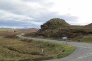
Dun Osdale, by the roadside

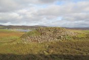
From the A863 Dunvegan road, a mile south of the village turn onto the B884 road at Lonmore, making sure you veer right after a few hundred yards and head towards Glendale.  About a mile along, on the left-hand side of the road, note the small rocky crag that begins to grow just above the roadside.  At the end of this crag you’ll see a huge pile of rocks, seemingly tumbling down, just by a small T-junction to Uiginish.  You can’t really miss it.

Archaeology & History

Listed as one of the duns, or fortified prehistoric structures in Skye by the old writer J.A. MacCulloch (1905), the rediscovery of this broch was, said A.A. MacGregor (1930), one that “became historical only within living memory.”  I find that hard to believe!  The Gaelic speakers hereby merely kept their tongues still when asked, as was common in days of olde—and it was a faerie abode….
Looking at the SW walling
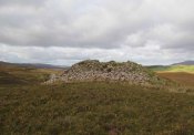
Looking at the SE walls

Once you go through the gate below the broch, the large boggy area you have to circumnavigate is the overflow from an ancient well, known as Tobar na Maor, where Anne Ross said, “tradition that the stewards of three adjacent properties met there.”  This well was covered by an ancient Pictish stone (now in Dunvegan Castle), which may originally have been associated with the broch just above it.  When I visited the site with Aisha and Her clan, we passed the overgrown well and walked straight up to the broch.

Despite being ruinous it is still most impressive.  The massive walling on its southwestern side is still intact in places; but you don’t get a real impression of the work that went into building these structures until you’re on top.  The walls themselves are so thick and well-built that you puzzle over the energy required to build so massive a monument.  And Scotland has masses of them!
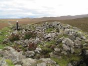
Aisha in the broch
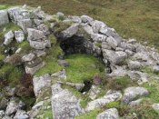
Small internal chamber

The site was surveyed briefly when the Ordnance Survey lads came here in 1877, subsequently highlighting it on the first OS-map of the area.  But it didn’t receive any archaeocentric assessment until the Royal Commission (1928) lads explored the area some fifty years later.  In their outstanding Inventory of the region they described Dun Osdale in considerable detail, although kept their description purely architectural in nature, betraying any real sense of meaning and history which local folk must have told them.  They wrote:

“The outer face of the wall of the broch for a great part is reduced to the lower courses, but on the west-southwest a section still maintains a height of about 7 feet; on the south-side, although hidden by fallen stones, it is about 4 to 5 feet high, and on the northeast there is a very short section 3 feet in height.  The stones are of considerable size and laid in regular courses.  In the interior a mass of tumbled stone obscures the most of the inner face of the wall, but on the south and northwest it stands about 8 feet above the debris.  The broch is circular with an internal diameter of 35 feet to 35 feet 6 inches, and the wall thickens from 10 feet on the north to 13 feet 7 inches on the south. The entrance, which is one the east, is badly broken down, but near the inside has a width of 3 feet 2 inches, and appears to have been 2 feet 10 inches on the outside; it has run straight through the wall without checks.  In the thickness of the wall to the south of the entrance is an oval chamber measuring 10 feet long by 4 feet 9 inches broad above the debris with which it is half-filled.  The roof has fallen in, but the internal corbelling of the walls is well displayed.  The fallen stones no doubt still cover the entrance, which has probably been from the interior.  Within the western arc of the wall, nearly opposite the main doorway, is another oval cell 12 feet in length and 4 feet 6 inches in breadth over debris, with a doorway 2 feet 9 inches wide; its outer and inner walls are 5 feet 9 inches, and 2 feet 6 inches respectively.  The roof od this chamber has also collapsed, but from the masonry which remains in position it must have been over 6 feet in height.  Immediately to the west of the cell near the entrance are exposed the left jamb of a door and a short length of a gallery 3 feet 6 inches wide in the thickness of the southern wall, which probably contained the stairs, as traces of a gallery at a higher level than the oval chambers are seen here, the inner wall being about 3 feet and the outer 8 feet thick. Parts of a scarcement 9 inches wide can be detected on the northwestern and southeastern arcs.”
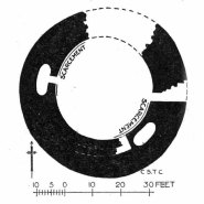
Dun Osdale plan (RCAHMS 1928)
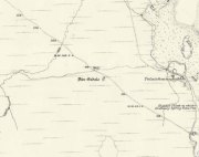
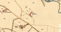
Dun Osdale on 1881 map

Measurements and architectural tedium aside, the broch is worthwhile for anyone interested in our ancient mythic past, not least because of its position in the landscape and its visual relationship with other sites of the same period nearby.  As well as that, there are unrecorded ancient sites still hiding in these olde moors…

Folklore

Tradition tells that Dun Osdale was used as a watch-tower by the tribal folk—which seems quite credible.  But the original inhabitants of Duirinish, the sith or fairy folk, were also said to live here.  It’s one of several places in Duirinish where the legendary Fairy Cup of Dunvegan was said to have come from.  Otta Swire (1961) told its tale:

“One midsummer night a MacLeod, searching for strayed cattle, stayed late on the moor.  In the moonlight he saw the door of Dun Osdale open and the little people come out, a long train of them, and began to dance on the green grass knoll nearby.  Fascinated, he watched, forgetting everything but the wonderful dance. Suddenly he sneezed.  The spell was broke.  The dance stopped.  MacLeod sprang up to fly, but the fairies were upon him and he was dragged, willy-nilly, into the dun.  Inside, as soon as his eyes grew accustomed to that strange green light associated with fairyland, he beheld a pleasing sight.  A great banquet was spread on a large table carved from a single tree: on it were vessels of gold and silver, many of them set with jewels or chased in strange designs.  His fairy ‘hosts’ led him to the table, poured wine into one of the beautiful cups and, giving it to him, invited him to toast their chief.  Now this man’s mother was a witch, so he knew well that if he ate or drank in the dun he was in the Daoine Sithe’s power for ever.  He lifted the cup and appeared to drink the required toast, but in fact skilfully let the wine run down inside his coat.  As soon as his neighbours saw the cup was half empty, they ceased to bother about him but went off on their own affairs or to attend the banquet.  Thereafter MacLeod watched for a chance of escape and, when one offered, slipped quietly through the door of the dun and away, carrying the cup with him.

“The fairies soon realised what had happened and started in pursuit, but he was already across the Osdale river and in safety.  He hurried home, told his mother the story, and showed her the cup.  Being a wise woman she realised the peril in which he undoubtedly stood and at once put her most powerful spell upon him to protect him from the arts of the Daoine Sithe, warning him seriously never to leave the house for a moment without getting the spell renewed.  But she forgot to put a protecting spell upon the cup also.  The fairies soon discovered the exact state of affairs and immediately laid their own spell upon the cup, a spell so powerful that all who saw the cup or even heard of it, were seized with an overmastering desire to possess it, even if such possession involved the murder of the holder.

“For a year, all went well and thanks to his mother’s care the young man went unharmed.  Then he grew careless and one day ventured out without the protecting spell.  A one-time friend, bewitched by the cup, had been awaiting just such a chance and immediately murdered him and went off with the prize.  The fairies, their revenge achieved, took no further interest in the matter, but MacLeod of MacLeod did.  The boy’s mother hurried to him with her story, and he at once gave orders that the murderer be found and brought to justice.  He was duly hanged and the trouble-making cup, now free of enchantment, passed into the possession of the chief and can still be seen in (Dunvegan) castle.”

References:

  1. Donaldson-Blyth, Ian, In Search of Prehistoric Skye, Thistle: Insch 1995.
  2. MacCulloch, J.A.,  The Misty Isle of Skye, Oliphant, Anderson & Ferrier: Edinburgh 1905.
  3. MacGregor, Alasdair Alpin, Over the Sea to Skye, Chambers: Edinburgh 1930.
  4. Royal Commission on Ancient & Historical Monuments of Scotland, Inventory of Monuments and Constructions in the Outer Hebrides, Skye and the Small Isles, HMSO: Edinburgh 1928.
  5. Swire, Otta F., Skye: The Island its Legends, Blackie & Sons: Glasgow 1961.

Acknowledgements:  Eternally grateful to the awesome Aisha Domleo and Her little clan for getting us to this ancient haven on Skye’s endless domain of natural beauty.  Without Her, this would not have been written.  Also, accreditation of early OS-map usage, reproduced with the permission of the National Library of Scotland.

© Paul BennettThe Northern Antiquarian
The map could not be loaded. Please contact the site owner.


Tongue House, Tongue, Sutherland

Chambered Cairn:  OS Grid Reference – NC 5926 5862

Also Known as:

  1. Canmore ID 5325

Getting Here

Tongue House chambered cairn amidst the trees

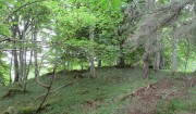
I approached this by walking along the B8438 road northwest out of Tongue village, towards the road-crossing over the Kyle of Tongue.  There’s a small tiny road on the right (easily missed) nearly a mile out, just as the road starts to bend, which leads you down to Tongue House.  Go along here for about 325 yards (300m) and just as the road bends to the left, walk into the woods. Keep straight forward, following the low-level stream, and when you see the buildings ahead of you, veer diagonally upslope until you hit the large Tongue Burn. Cross this and walk uphill to the tree-covered knoll ahead. You’re there!

Archaeology & History

…and again, looking north

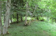
From the descriptions I’d read of this site, I wasn’t expecting much at all—but it was much better than I anticipated, and in a beautiful woodland setting too.  Admittedly the site is much overgrown, but the overall size, edges and outline of the tomb is easily discernible.  In pacing across it, from outer-edge to outer-edge, it measured 18 yards by 19 yards across.  All round the edges are many overgrown tumbles of smaller rocks which obviously had been part of the cairn in previous centuries; but it is primarily defined by the larger earthfast rocks at the very top of the natural knoll in the trees, all of them covered in deep mosses.

The site was first mentioned in James Horsburgh’s (1870) survey of the region.  He explored a small section of the monument and, upon digging, found a chamber therein—defined by Audrey Henshall (1963) as “a single compartment chamber”—telling us:

“A little to the south of Tongue House, and near the fountain head that supplies it with water, there is the chamber of a cairn of the same description as that near Skelpick, but rather smaller; on clearing it out, I found that one of the large upright stones had two holes bored artificially a short way into each of its sides, but not quite opposite, the holes were about 3 inches diameter.”

However, these internal structures have not been seen since and in Henshall & Ritchie’s (1995) catalogue of Sutherland’s giant tombs, there is some confusion over the definition of the structure itself, questioning whether or not it was indeed a chambered tomb.

“The ‘chambered cairn’ is a circular stone structure overgrown with small trees and covered in leaf-litter and moss.  A kerb about 15m in diameter can be traced for much of the circuit.  The kerb is of unusually substantial and closely-set boulders which have the appearance of the base of a massive wall such as is inappropriate for a dun or a broch rather than a cairn.  The interior is filled with loose stones including some quite large boulders, roughly to the level of the top of the kerb.  There is no indication that these boulders have formed part of a neolithic chamber or that the structure was a cairn.  There seem to be three possibilities: that the structure is not Horsburgh’s cairn; that the structure is that which he investigated but that he was mistaken in regarding it as a chambered cairn; that the writers are mistaken in identifying the structure as a ruined broch or dun.”

Despite this, the general consensus today is that the monument is indeed a chambered cairn.

References:

  1. Henshall, Audrey S., The Chambered Tombs of Scotland – 2 volumes, Edinburgh University Press 1963 & 1972.
  2. Henshall, Audrey S. & Ritchie, J.N.G, The Chambered Cairns of Sutherland, Edinburgh University Press 1995.
  3. Horsburgh, James, Notes of Cromlechs, Duns, Hut-circles, Chambered Cairns and other Remains, in the County of Sutherland“, in Proceedings Society of Antiquaries, Scotland, volume 7, 1870
  4. Royal Commission on Ancient & Historical Monuments, Scotland, Second report and inventory of monuments and constructions in the county of Sutherland. HMSO: Edinburgh 1911.

© Paul BennettThe Northern Antiquarian

The map could not be loaded. Please contact the site owner.


Dunvarich, Tongue, Sutherland

The map could not be loaded. Please contact the site owner.

Souterrain (lost):  OS Grid Reference – NC 59 57

Also Known as:

  1. Canmore ID 5341

Archaeology & History

Site of the lost souterrain

There are a number of souterrains—or “earth houses” as they used to be known—in Sutherland that have been lost.  Many have simply fallen prey to being filled-in or covered over.  This is one such site, found in the fields between Tongue village heading out towards the sea-bridge crossing the Kyle.  In a brief excursion I made to the area a few days ago, I couldn’t locate the site and no one I spoke to seemed to know anything about it.  I’m assuming that the site has simply been blocked-up and overgrown, hiding beneath the green pastures above the sea-line.

Its exact whereabouts is difficult to ascertain, for when it was described in Mr Horsburgh’s (1870) excursion to the area, the location he gave for it was somewhat vague, telling:

“Between Tongue House and Kirkiboll, in a field on the right of the road, there is an Eirde house, which I opened for examination (it had often been opened before); it is now about 25 feet long, 2½ feet broad at the entrance, and widens to 4 feet at the far end, where it terminates in a circle; the sides are built with small stones without mortar, and the top covered with large flat slabs.”

This places the location of the souterrain anywhere in the fields between grid-references NC 5904 5815 to the north (near Tongue House) and NC 5901 5678 to the south.  If anyone knows anything about this site, please let us know.

References:

  1. Horsburgh, James, Notes of Cromlechs, Duns, Hut-circles, Chambered Cairns and other Remains, in the County of Sutherland“, in Proceedings Society of Antiquaries, Scotland, volume 7, 1870

© Paul BennettThe Northern Antiquarian

Deanside, Tongue, Sutherland

The map could not be loaded. Please contact the site owner.

Souterrain (destroyed):  OS Grid Reference – NC 591 556

Also Known as:

  1. Canmore ID 5343
  2. Dionaite

Archaeology & History

Location of Deanside souterrain

Nothing now remains of the prehistoric underground chamber, “eirde House” (as they were called) or souterrain, that was reported by the northern antiquarian James Horsburgh when he was exploring the sites here in the 1860s.  Found near Deanside a couple of miles south of Tongue, alongside the edge of the Allt an Dionaite (Deanside Burn), even in his day there wasn’t much of it left.  It was one of a number of souterrains in the region that he was shown, presumably by local people, telling us briefly that,

“Near Deanside, there were remains of the end of another (souterrain) on the bank of the burn, but it has since been washed away in a flood.”

In an exploration up the side of the burn today, I could find no remains whatsoever; although I didn’t walk too far up and have a feeling that its position would have been further up than where I got to.  In a brief chat with some of the old people living in the neighbourhood, they told me they had no memory of the site.

References:

  1. Horsburgh, James, Notes of Cromlechs, Duns, Hut-circles, Chambered Cairns and other Remains, in the County of Sutherland“, in Proceedings Society of Antiquaries, Scotland, volume 7, 1870

© Paul BennettThe Northern Antiquarian
Croc-tigh-goil, Ribigill, Tongue, Sutherland

Standing Stones (destroyed):  OS Grid Reference –  NC 582 541

Also Known as:

  1. Canmore ID 5349

Archaeology & History

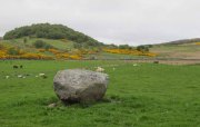
Large stones in field to the north

When I visited this place last year, I had a good look all around for any trace of what James Horsburgh (1870) told us about 150 years earlier, i.e., monoliths that had been broken up and used in the making of the road.  Sadly I found nothing.  When I enquired about the stones amongst local people, they were unaware of any such site and it had fallen out of oral tradition amongst them.  Mr Horsburgh told us simply:

“Near Ribegal there used to be three upright stones, called by the old people a Teampul.  They were broken up by Mr Mitchell, the late farmer, and are now built into the dyke at the road side; the hillock on which they stood is still called Croc-tigh-goil, the ‘hillock of the school-house’.”

However, in the fields 300 yards to the north, three large stones are visible—almost in a straight line—but they seem to be Nature’s handiwork; although the southernmost stone looks like it might once have stood upright.  But I think I’m being more hopeful than realistic!

References:

  1. Horsburgh, James, Notes of Cromlechs, Duns, Hut-circles, Chambered Cairns and other Remains, in the County of Sutherland“, in Proceedings Society of Antiquaries, Scotland, volume 7, 1870.

© Paul BennettThe Northern Antiquarian

The map could not be loaded. Please contact the site owner.