Cliff Cottage Circle, Broad Haven, Pembrokeshire

Stone Circle (destroyed):  OS Grid Reference – SM 8615 1428

Archaeology & History

Described in context with an extant standing stone 100 yards to the north, this stone circle seems to have been destroyed in the latter half of the 19th century.  It was described in the Royal Commission’s huge Pembrokeshire (1925) survey, after they had visited the site and viewed the remains.  They told us:

“On the side of the road immediately opposite to Cliff Cottage, and constituting part of the garden walls of Upper Lodge, are numerous boulders which formed a well-defined stone circle.  A few years ago they were moved, dressed, and used for walling.  The entrance to the circle is said to have faced north-east.  The southern portion was still visible about the year 1896.”

As far as I’m aware, local people report that a couple of the stones are still visible in the overgrown walling.  Students working for the Welsh Coflein database allege that the remaining stones “are of doubtful antiquity.”  Unless they have some substantial evidence to validate this statement (none is given) their remarks should be taken with a pinch of salt.

References:

  1. Royal Commission Ancient & Historical Monuments, Wales, An Inventory of the Ancient Monuments in Wales & Monmouthshire: VII – County of Pembroke, HMSO: London 1925.

© Paul BennettThe Northern Antiquarian

Ellen’s Well, Angle, Pembrokeshire

Holy Well (lost):  OS Grid Reference – SM 86913 03483

Archaeology & History

Ellen’s Well on 1869 map

Very little seems to be known about this apparently lost site, deemed to be an authentic holy well in Francis Jones’ (1954) fine survey: the ‘Ellen’ in question here being the legendary St Helen.  It was highlighted on the first OS-map of the area in 1869 and subsequently included in the Royal Commission’s huge Pembrokeshire (1925) tome, but when they came to visit the site they reported that “it could not be traced, nor any information obtained about it.”  Has it truly fallen back to Earth, or do any local historians and antiquarians know where it is…?

References:

  1. Jones, Francis, The Holy Wells of Wales, University of Wales 1954.
  2. Royal Commission Ancient & Historical Monuments, Wales, An Inventory of the Ancient Monuments in Wales & Monmouthshire: VII – County of Pembroke, HMSO: London 1925.

© Paul BennettThe Northern Antiquarian


Parc-y Meirw, Llanychaer, Pembroke

Standing Stones:  OS Grid Reference – SM 9988 3591

Also Known as:

  1. Parc y Marw
  2. Parc y Meirw

Archaeology & History

Parc y Meirw - by Liz Haines
Parc y Meirw – by Liz Haines

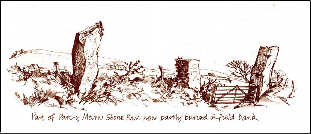
This is an impressive and well-known megalithic stone row, found just 4-5 miles inland from the coastal town of Fishguard.  The drawing here is used courtesy of Elizabeth Haines, landscape artist, and gives a fine representation of the site as I’m sure you’d agree!  Consisting of at least eight standing stones — four still upright and four laid down — aligning northwest to southeast, the tallest stone stands at the southerly end measuring 11 feet tall.  The stone row is found in a region rich in prehistoric remains.  Aubrey Burl (1993) said of the place:

“Four of the eight stones in this unusual row still stand, trapped in a  field-wall, tow of them now gateposts.  Thom suggested that the line, 131ft (40m) long, was laid out downhill towards the WNW and the minor northern moonset just north of Mount Leinster ninety-one miles away across the Irish Sea.”

Quite a distance!  And perhaps because of this, Burl thought that the nature of this line of stones was more archaeological than astronomical, with its focal point being more likely up the slope to the ESE instead.

Folklore

There was once an adjacent chambered tomb here which, when it was “destroyed for a house in 1844 brought the owner no luck” (Thom, Thom & Burl 1990) – which is damn good to hear!  There was a piece of folklore mentioned by E.L. Barnwell (1868) and other writers that the fields here marked the fall of three Welsh princes in the Battle of Mynydd Carn in 1084.  In Roger Worsley’s (1988) fine tour of Pembrokeshire’s historical sites, he tells how these megaliths in the “field of the dead” are also haunted, saying:

“A local tale tells of Ladi Wen, a ghostly White Lady wandering about the fields at night, and who will kill anyone who ventures near; it was enough to keep villagers away from the site well into this century, though the stone row is over five thousand years old.”

References:

  1. Barber, Chris & Williams, John Godfrey, The Ancient Stones of Wales, Blorenge: Abergavenny 1989.
  2. Barnwell, E.L., “Alignments in Wales,” in Archaeologia Cambrensis, volume 14, 1868.
  3. Burl, Aubrey, From Carnac to Callanish, Yale University Press 1993.
  4. Thom, Alexander, Thom, A.S. & Burl, Aubrey, Stone Rows and Standing Stones, BAR 560: Oxford 1990.
  5. Worsley, Roger, The Pembrokeshire Explorer, CCP: Abercastle 1988.

ACKNOWLEDGEMENTSA huge thanks to Elizabeth Haines, Landscape Artist, for use of her drawing of Parc-y Meirw.

© Paul Bennett, The Northern Antiquarian