Simply what the term suggests: upright singular or multiple sets of stones plonked there thousands of years back (traditionally betwixt neolithic to Iron Age) for various uses. Some relate to burial; others to land-markers (tribal boundaries, etc); some may be alignment-markers (solar and lunar); others simple meeting spots (moots). They are closely related to stone circles, tombs, and many of them are outliers to such sites.
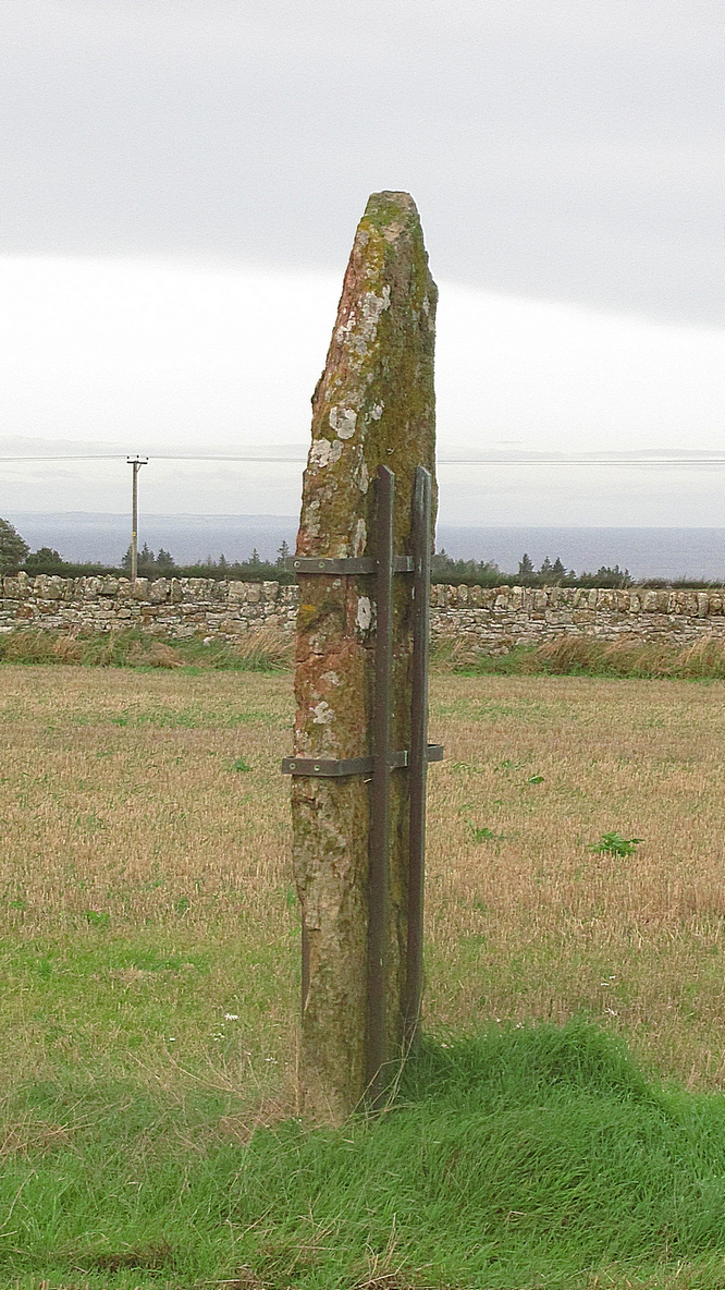
The first that I read of this place was in an article of the Scottish Ecclesiastical Society journal, on the parish history of Horndean. Standing originally at the edge of the ruined remains of the old churchyard, the author W.S. Moodie (1915), told that a long lost,
“grim relic of olden days is said to have existed here till fifty years ago. This was the Witches Stone—an upright pillar with a hole in it, to which the bodies of the poor unfortunates were fastened after they had been glede, while the faggots were piled around.”
A perusal in the Royal Commission inventory (1915) of the same year told that it had been moved several miles northeast to Paxton Cottage (NT 9279 5229) in the adjacent village. It was described as being,
“about 4 feet 6 inches in height above the ground, some 2 feet in breadth, tapering towards the upper end, and about 7 inches thick. Near the top are two perforations, not quite on the same level, about 2 inches in diameter at the surface on either side, constricted towards the Centre, and about 9 inches distant from centre to centre.”
Is this old stone still in existence…?
References:
Moodie, W. Steven, “Ladykirk, or the Kirk of Steill, Berwickshire,” in Transactions of the Scottish Ecclesiological Society, 4:3, Aberdeen 1915.
Royal Commission Ancient & Historical Monuments, Scotland, Inventory of Monuments and Constructions in the County of Berwick, HMSO: Edinburgh 1915.
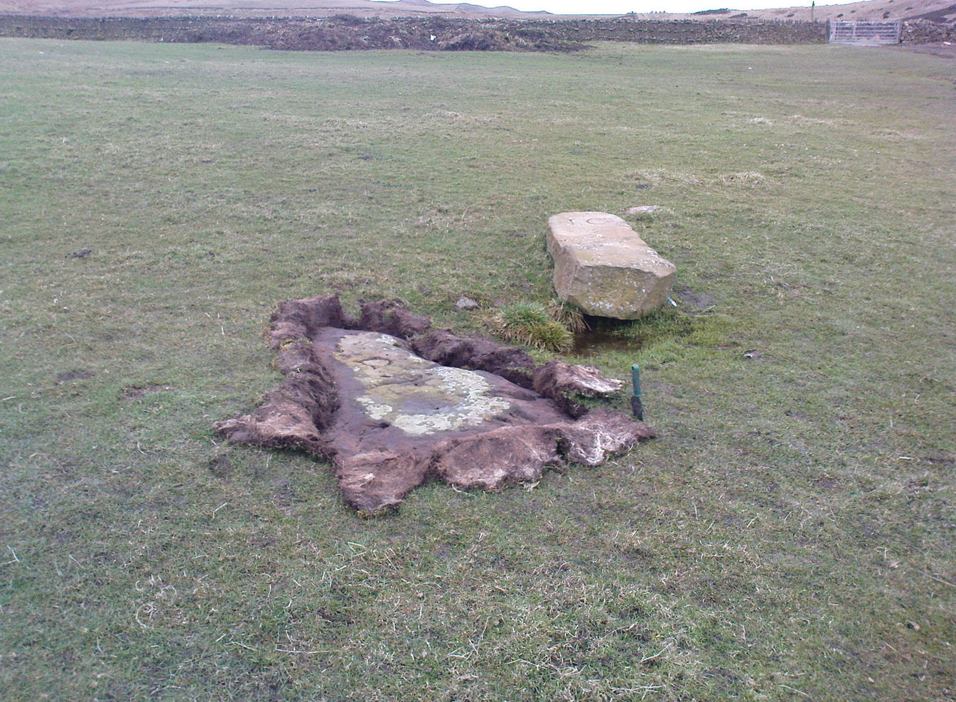
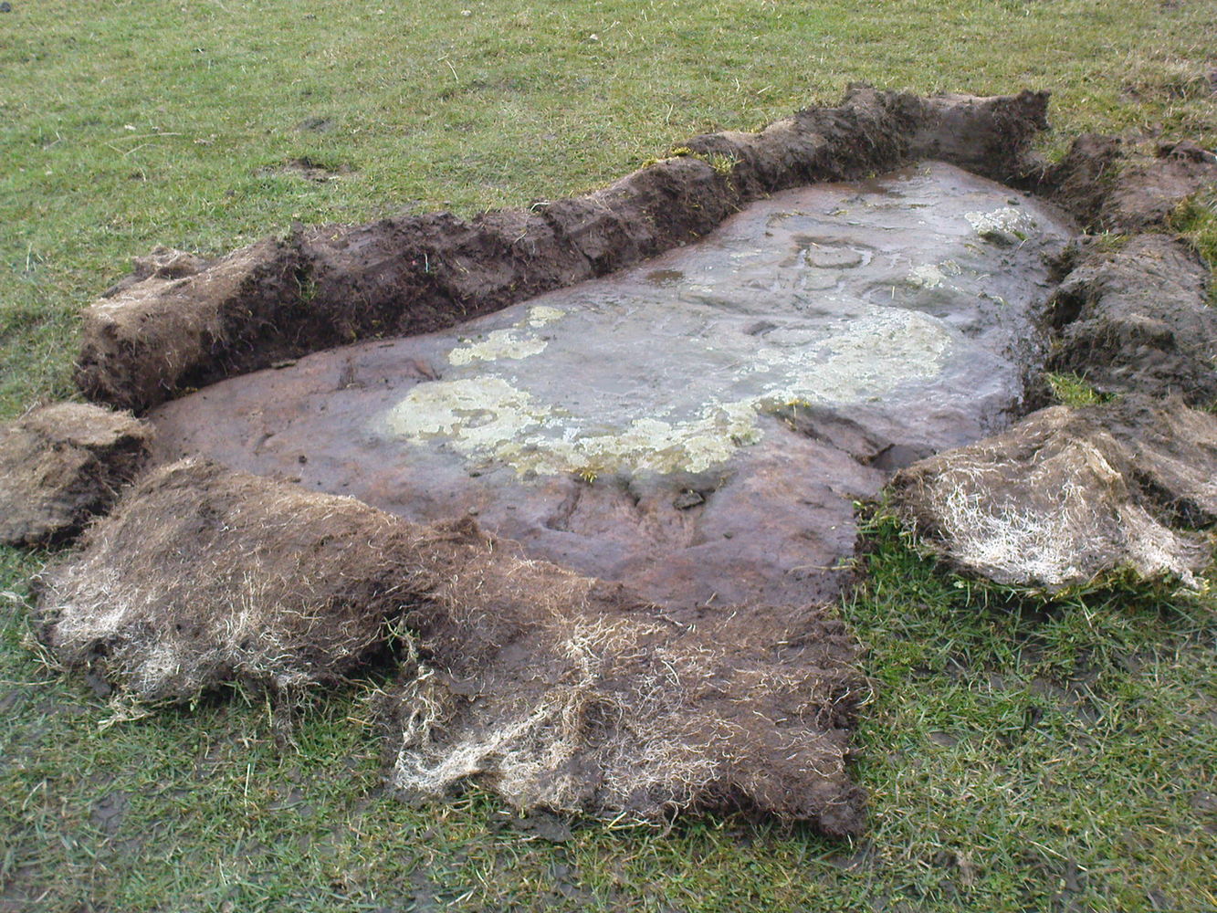
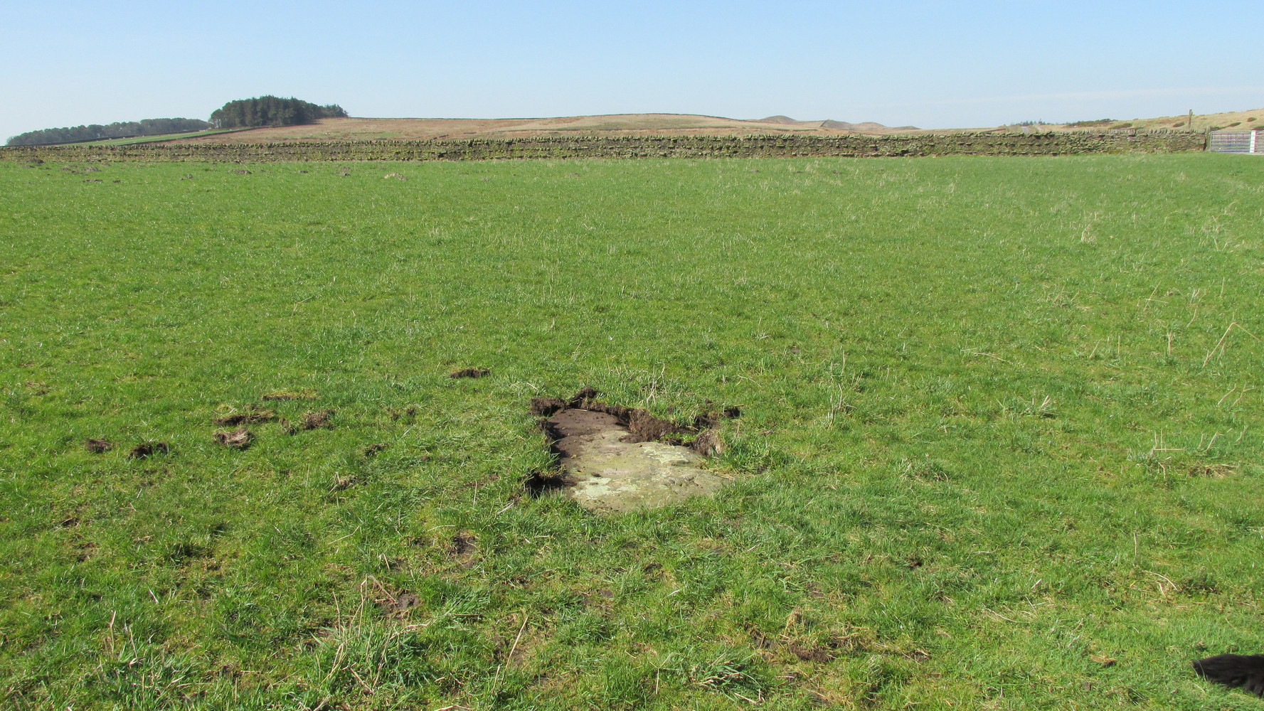
Probably the easiest way here is to take the well-trodden Dales High Way track westwards, under the bypass from Addingham, and along the old Roman Road. After 1.7 miles (2.7km) you’ll reach the Heights Lane country road. Stop here! Walk back on yourself along the track for maybe 50 yards and look in the field to your right (south) between 10-20 yards in the short grass and there, somewhere under your feet next to a modern stone, you’ll see peeking up at you (probably somewhat covered on the whole by the soil) a long flat stone. That’s what you’re looking for.
Archaeology & History
This old stone had been sought after by various groups and people for many years and I was fortunate to relocate it about thirty years ago, laid down and all-but-hidden beneath the grasses. The stone appears to have been buried nearly 100 years earlier, because when Harry Speight (1900) wrote about it in 1900 he described it as still upright. In more recent years, it seems that the farmer has put a replacement stone next to its position with the letters “JC” cut into it. You can see it in the above photo.
Thief Thorne uncoveredThief Thorne, looking W
First mentioned in the 16th century and included in boundary perambulation records of 1709, and again in 1781, someone during that period turned it into a milestone, etching the words “To Skipton 3 m. To Addingham 2 m.” It stood by the old Roman road, but its considerable erosion and shape is decidedly prehistoric. Nearly 6 feet long, it is now laid in the earth and almost completely covered over. A sure case for resurrection.
References:
Bennett, Paul, The Old Stones of Elmet, Capall Bann: Milverton 2001.
Speight, Harry, Upper Wharfedale, Elliott Stock: London 1900.
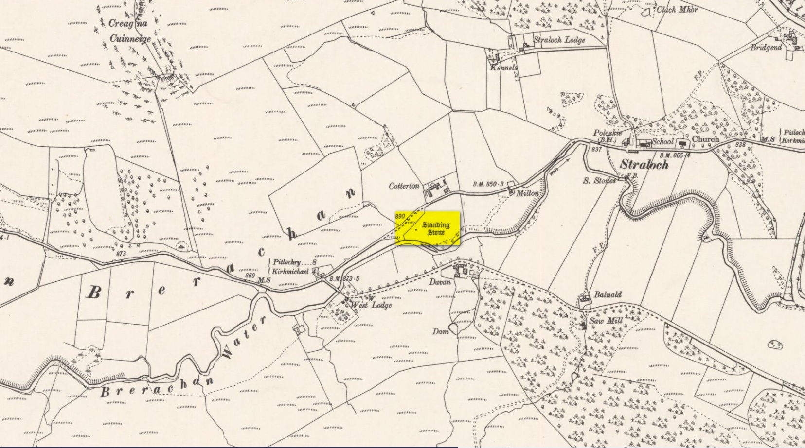
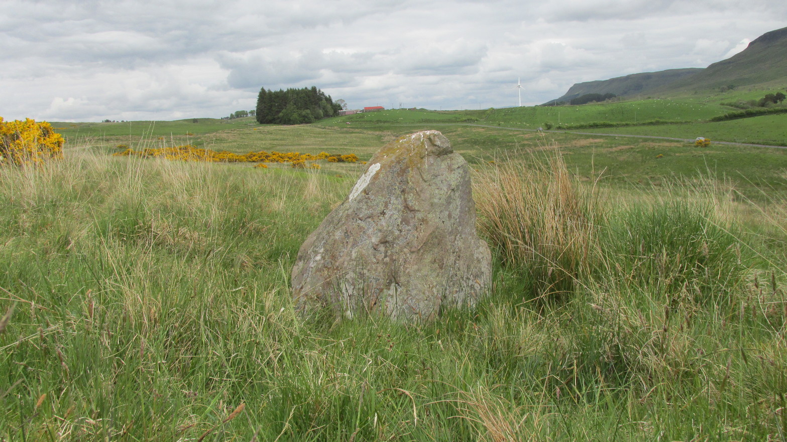
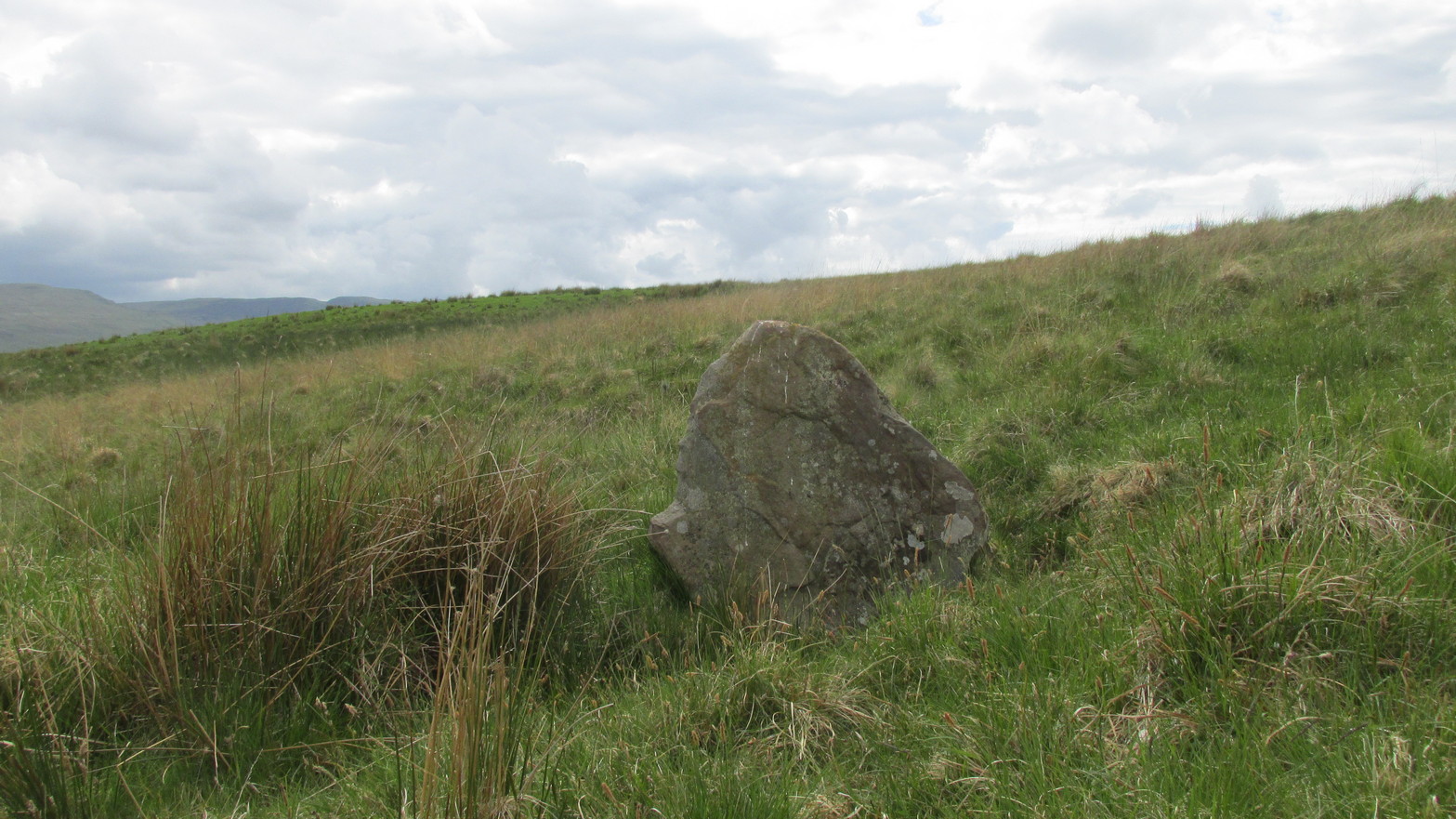
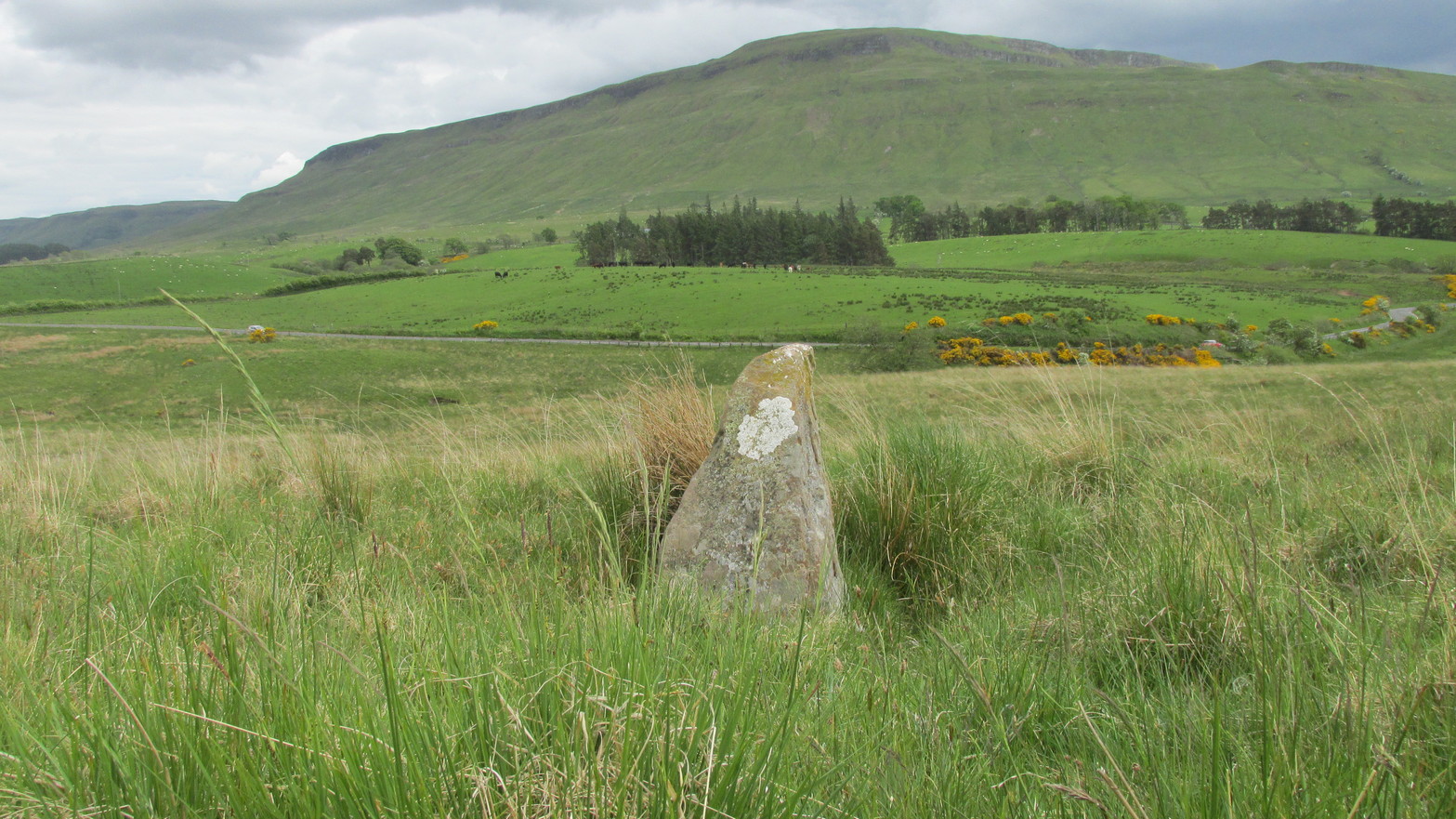
Along the A924 road, just over 4 miles (6.6km) NW from Kirkmichael, or about 8 miles (13km) NE from Pitlochry, you’ll hit the large farmhouse of Straloch. You’ve really gotta keep your eyes peeled! A few hundred yards west of Straloch itself, a small parking spot is on the south-side of the road, above the river. From this parking spot, walk a few yards to the fence that overlooks the river and look into the field below you, where you’ll see the stone. If y’ walk down the slope, you’ll see a gate on the right that leads you into the field.
Archaeology & History
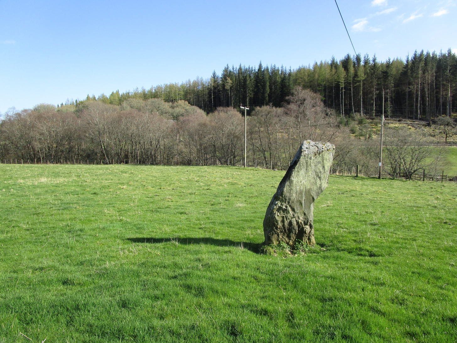
First shown on the 1900 OS-map of the area, this petrified hunchbacked witch-of-a-stone stands on the flat grassland plain (previously scattered woodland when first raised) forty yards from the River Brerachan: a proximity characteristic found at many of the stones along Strathardle.
Cotterton stone 1900 mapFred Coles’ sketch
Descriptions of the site prior to 1900 seem non-existent (does anyone know otherwise?). It was the brilliant antiquarian Fred Coles (1908) who, it seems, was the first to mention the old stone — whose very crooked appearance had an unusual effect on him, saying how “such a decided leaning over towards the north…almost make one uneasy when standing beside it”! It didn’t have that effect on me, but I was mightily impressed by both its appearance and curious hunched gait. Twas one of those monoliths that had a distinct ‘feel’ about it, which many people report at such places up and down the country. Whether it was its position by the river, or the color of the landscape, or the silence, or the shape of the stone, or combinations of them all—which ever it was, there was almost a sense of genius loci residing here…
But in that other world of pragmatic measurements, as Mr Coles told us:
“The Stone is at the base an oblong in shape, measuring 14 inches on its east end, 2 feet 7 inches along its south side, 17 inches at the west, and 3 feet 6 inches on its north side—a girth, therefore, of 8 feet 8 inches. At the middle its dimensions are the same, but the top is rather less. At its N.E. apex the Stone is 7 feet 8 inches clear of the ground, and at the west edge 7 feet. In the illustration…I have shown the monolith from the south, with the craggy profile of Menachban in the background.”
The stone was mentioned in passing in Hugh Mitchell’s (1923) local survey. A few years later in John Dixon’s (1925) account he repeated the dimensions of the stone that Coles had cited; and although he found there to be no known traditions of the place, he conjectured how it may have been connected with the numerous battles “that in former days occurred along this entrance to the Highlands.”
It’s a damn good site is this. All you megalith hunters will love it!
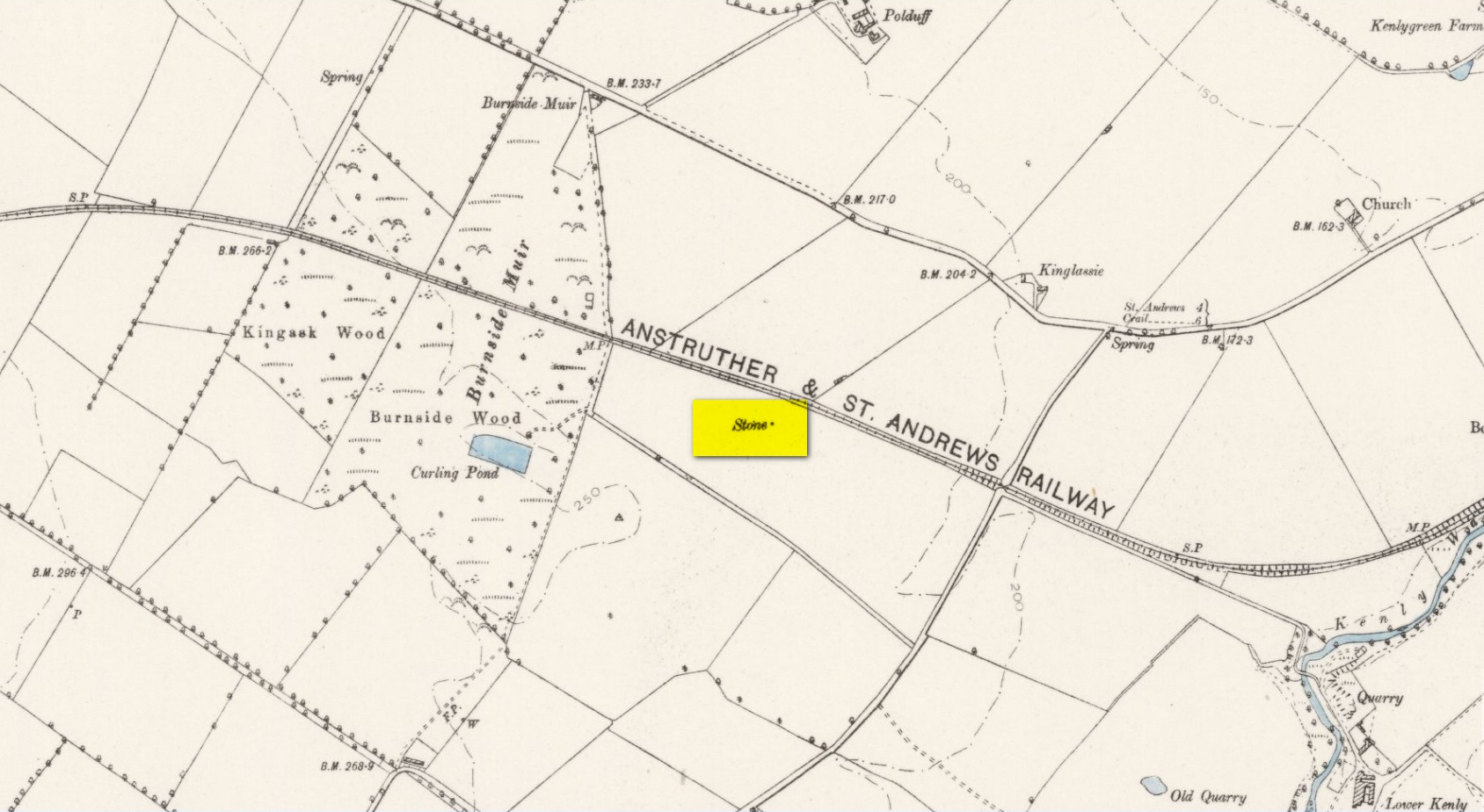
Take the A917 road southeast out of St Andrews, heading towards the hamlet of Boarhills about 4 miles away. However, about a half-mile before you get to Boarhills, keep your eyes peeled for a small minor road on your right, signposted to Dunino, 3 miles. Go along here for about 350 yards where you’ll reach a track cutting across the road. Walk up the gently sloping field here on your right and you’ll see, 400 yards from the road whence you’ve parked, a tall thin upright stone standing alone…
Archaeology & History
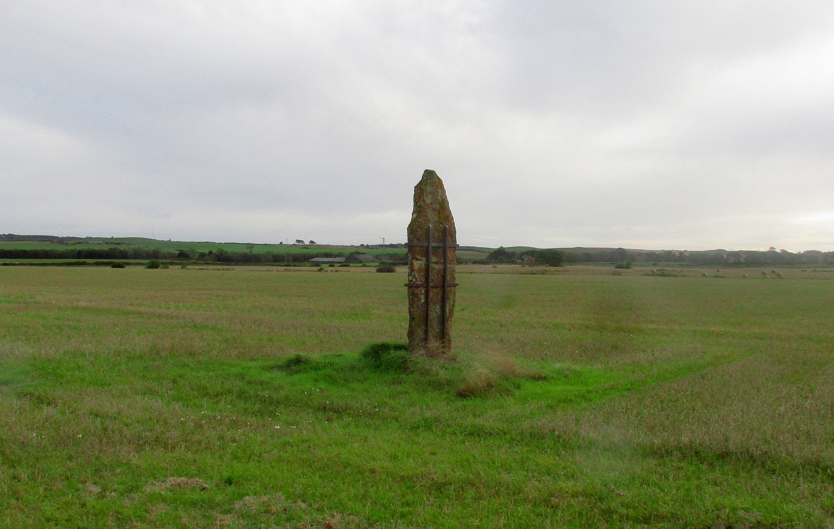
Highlighted on the 1893 and 1896 OS-maps (as merely a “Stone”), this tall and incredibly skinny standing stone has seen better days. After many-a-millenia, the god of storms cut the stone to the ground not too many years ago, leaving it broken in the middle o’ the field where once it stood. Thankfully however, local folk ensured that it was eventually resurrected and fixed into position once more, albeit in a somewhat ugly cage—or corset as Mr Hornby called it!
The Royal Commission (1933) lads checked the stone out for inclusion in one of their damn good surveys, they told us the following:
“About midway between the farms of Polduff and Peekie, and on the south side of the Anstruther and St Andrews Railway, 200 feet above sea level, there is a fine block of red sandstone, which rises to a height of just over 9 above ground. It averages 4¼ inches in thickness and measures 2 feet 4 inches wide across the broad faces. The stone has been set up with the major axis north-east and south-west and has been well packed round the base with smaller stones.”
Interestingly—to me anyhow—when the monolith was recently stood back in its upright position, the archaeo’s found a spring of water beneath it. Many dowsers (and I don’t mean the ones who fallaciously reckon they’re finding ‘energy lines’ all over the place) have found the crossing of underwater streams and water sources to be a common feature beneath megalithic sites.
Folklore
In Richard Batchelor’s (1997) short work on the ancient sites of this area, he calls attention to what a Mr N. Dow thought was a ley-line passing from the cairn on top of Kellie Hill 4¾ miles (7.64km) away, northeast to the Peekie Stone, and which Mr Batchelor points out is close to the major lunar standstill.
References:
Batchelor, Richard A., Origin of St Andrews, Shieling: St Andrews 1997.
Royal Commission on the Ancient & Historical Monuments, Scotland, Inventory of Monuments and Constructions in the Counties of Fife, Kinross and Clackmannan, HMSO: Edinburgh 1933.
Acknowledgements: Huge thanks to Paul Hornby for use of his photos.
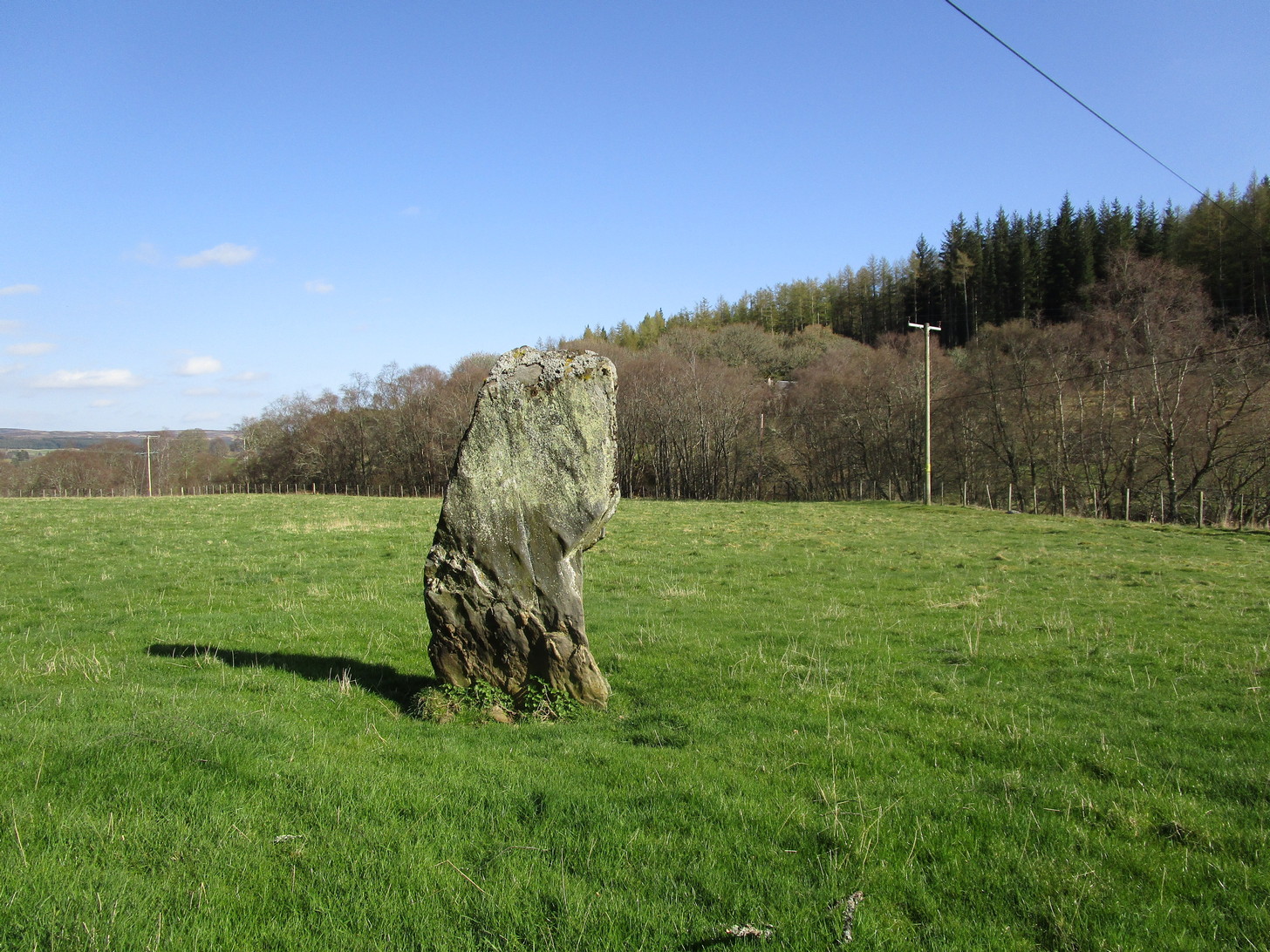
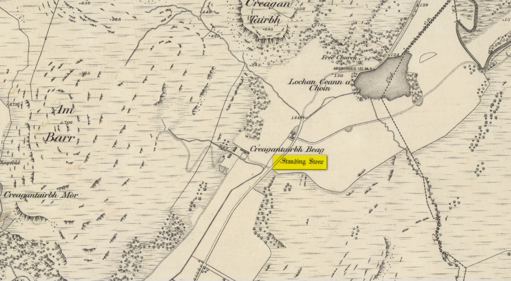
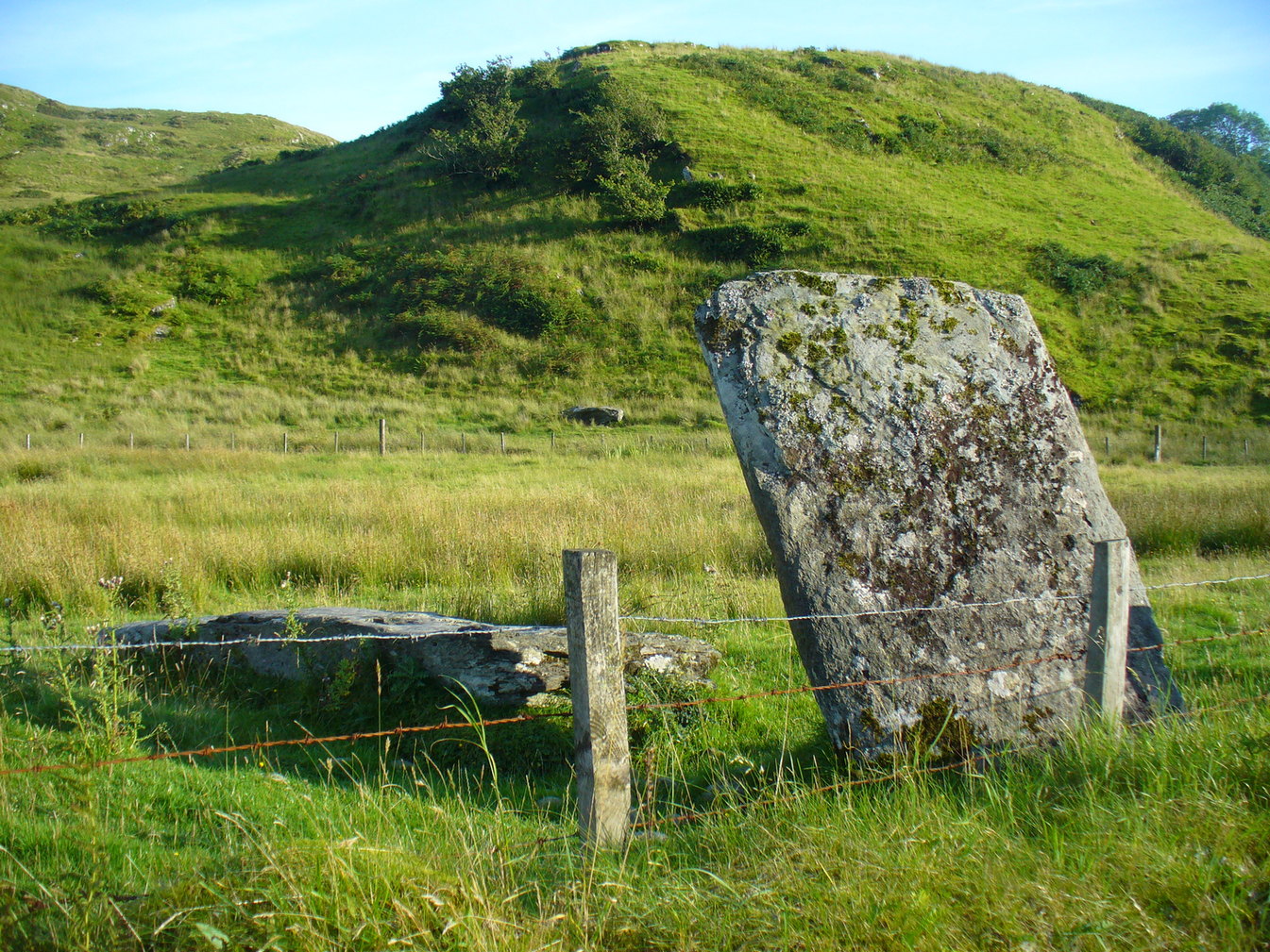
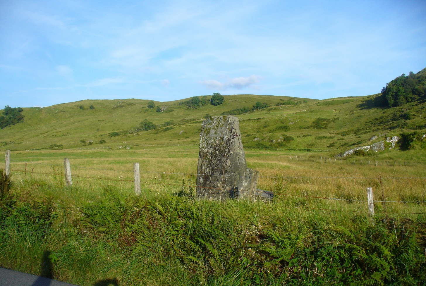
From Kilmartin go north on the A816 Oban road, and after 1½ miles watch out for the small B840 road on your right, to Ford and Loch Awe. Less than a mile along the winding road, just after the track to the farmhouse on your left, keep your eyes peeled for the standing stone on your right, whose top is peeking over the old walling. If you’re not careful you’ll miss it!
Archaeology & History
From the roadside this looks like just a reasonably small standing stone, but closer inspection shows it’s been snapped halfway up—apparently in a great storm in December 1879. If you look over the wall, just a couple of yards behind the upright you’ll see the larger section of stone that was attached to the 6-foot upright before its calamitous fall. Originally it was said to have been 16 feet tall!
Broken bit laid flatFrom the roadside
The first description of the stone is thought to be by the great J. Romilly Allen (1880) in his brief visit to Ford, saying simply that the stone “is close to the road on the east side, 1 mile from Ford. It is 14 feet high and 3 feet by 4 feet at the base. The material is slate. It inclines considerably from the perpendicular”—meaning, that he saw it before the stone had been broken. Lucky bugger!
More than twenty years later David Christison (1904) visited the site and wrote his of his finds in an essay for the Society of Antiquaries, although in truth he said little more than anyone before and after has been able to say:
“A mile and a quarter south-south-west of Ford Church, 130 yards east by south of Creagantairbh Beag farmhouse, close to the west side of the highway, stands the base of an obelisk, at the foot of which the shaft lies prostrate. The base is 5 feet 6 inches high,’and has an oblique ledge, half way up on to which the shaft would accurately fit. If restored, the height of the stone would be 16 feet 2 inches above ground, and it must have had a very handsome appearance, tapering in width as it gradually does from 2 feet 6 inches to 2 feet. It is 18 inches thick at the base and 10 inches to 12 inches at the top.”
Christison’s 1904 sketch
The name Creagantairbh derives from the Crag of the Bull, which is the sharp hill immediately in front of you to the north; and its geological consort, the Creag a’ Chapuill (or Crag of the Horse) rises to its immediate northwest. A few hundred yards further along the road towards Ford is the large Auchinellan standing stone.
Folklore
When I lived in Ford many years ago, the olde folk told me how, in bygone centuries, bulls were sacrificed on the Creagantairbh above.
Go up the B822 road from Fintry for literally 2.5 miles (about 500 yards below the small copse of trees that almost hide Balafark Farm above you) and at a very small ‘parking’ spot are 2 farm-gates. Go through the lower of the two and head downhill, crossing the small burn and up the other side for just over 100 yards where you’ll meet a very low, old and very overgrown wall. Keep your eyes peeled for it! Walk left along this wall, uphill, for another 100 yards till you meet a a dried-up dyke that runs downhill. 10-15 yards down this, a small stone greets you…
Archaeology & History
It’s difficult to call this a ‘standing stone’ and, as far as I’m concerned, is even more troublesome to cite it as a legitimate prehistoric monument. Nevertheless it is shown on the modern OS-maps as such and was listed by the Royal Commission (1963:1) lads in their standing stones inventory. But it’s really pushing it to be honest! They told us:
“This stone stands about 180 yds NW of a gate which opens off the Fintry-Kippen road, 340 yds N of its crossing of the Lernock Burn. It is triangular in profile and wedge-shaped in section, measuring 3’3″ both in height and breadth along its base, by 1’7″ in greatest thickness. It may well have been a boundary stone as it is near the corner of some ground which is enclosed by a turf dyke and has been cultivated.”
Looking southwestLooking up to the ancient cairn of Stronend
In truth, if we call this a standing stone, then there are hundreds of others that I’ve come across over the years—frobbling off-path across huge swathes of moorland—that must also be added to our prehistoric inventories, as the height of this isolated rock is echoed in countless others which are off the archaeological listings. One such stone ‘stands’ 100 yards northeast of here—although there are many others with much greater potential. …I think the only thing that may sway this as being a possible prehistoric upright is the fact that the top of the stone appears to have been broken off, albeit a few hundred years ago if the weathering is owt to go by. But a cursory look for any broken top-piece found nothing.
References:
Royal Commission on the Ancient & Historical Monuments Scotland, Stirling – volume 1, HMSO: Edinburgh 1963.
Take the B936 out of Auchtermuchty, and park at the small car park for Auchtermuchty Common on your right just before Lumquhat Mill. Follow the path through the Common southwards and along the narrow strip until the Common opens out past the boundary stone. Head for the sign board on the right and when you get there turn left and march straight up the hillock and the stone is ahead of you in front of a gorse bush.
Archaeology & History
A curious little stone that I found quite by chance. It is wedge shaped in plan, bearing one large cup mark on its top surface. The cup is approximately 2″ in diameter and about ¾” deep. The raised part of the stone is about 3′ high, it is 3′ long and about 13″ wide at the blunt south end, although at ground level it is nearly 3′ wide at this end.
The stone is orientated due N-S, the south end aligning with the peak of East Lomond (a mythic hill of which at least one legend survives), while the north end points to the river port of Newburgh. It gives the impression of having been carved as a direction marker from what was a much larger stone, which, if this is the case may have originally borne more cups.
Left to Right 1.Facing North – the stone looks to have been cut down from a larger boulder. 2. The summit of East Lomond due South. 3. Aligned North – South.The cup mark.
Folklore
The first time I visited, there were three small polished coloured stones at the foot of the rock, while the second time there were four stones within the cup. A long term resident out walking his dog told me he knew of no folklore relating to the stone, but that over the last thirty years he had kept seeing offerings of stones in the cup, so the rock clearly still has some ritual significance for local heathens/pagans…
Travelling north, turn right to Wolfhill off the A93 at Cargill, then up the hill, turning left at the first junction. The stones are buried in the field to your left before the bend.
Archaeology & History
The earliest description of these stones, and the only one written while they were still standing comes from J.P.Bannerman, writing in the Old Statistical Account in 1793:
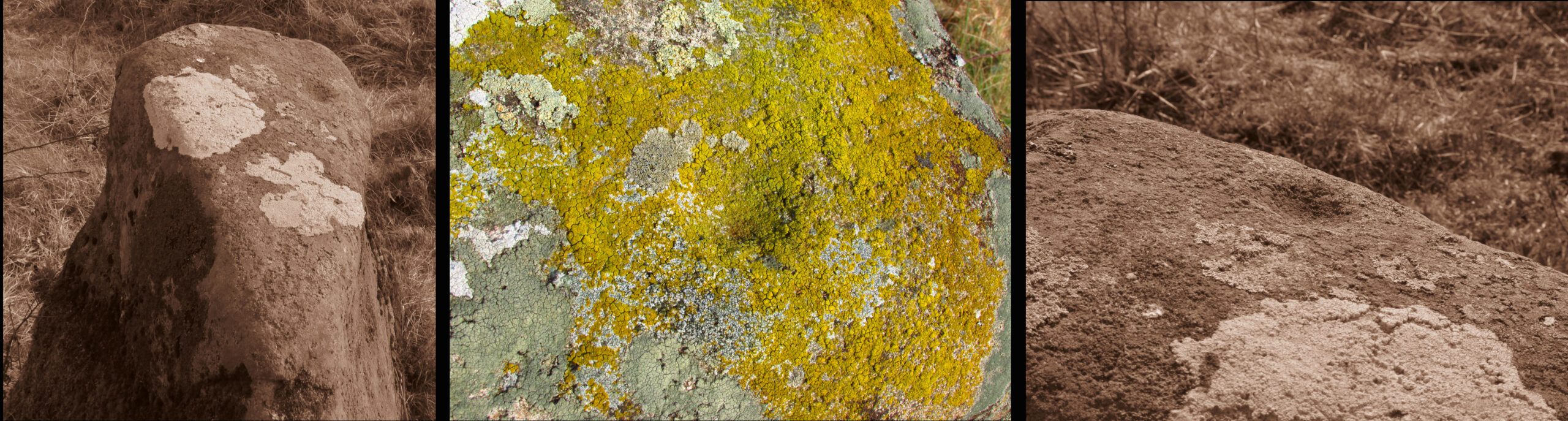
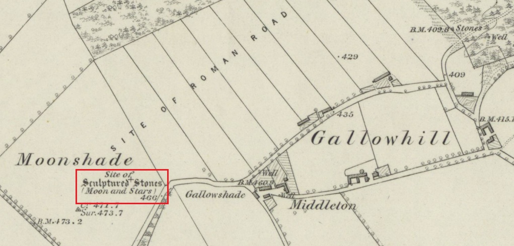
‘Near the village of Cargill may be seen some erect stones of considerable magnitude, having the figure of the moon and stars cut out on them, and are probably the rude remains of Pagan superstition. The corn-field where these stones stand is called the Moonshade to this day.’
Later writers, who only had verbal reports of the stones from locals who remembered them, gave differing descriptions of them. The people who spoke to the Ordnance Survey name book scouts around 1860, described them as:
‘Moonshade – “This name is applied to an arable field immediately west of Gallowhill. Two large Standing Stones having the representation of the Moon and 7 Stars cut out on one of them were removed from this field about 60 years ago.”‘
The local antiquary Andrew Jervise wrote in 1861 that the stones were:
‘interesting relics….purposely buried below the reach of the plough, appear to have been of the same class of antiquities as the sculptured stones at Meigle and, from the desire which is now being manifested for the preservation of national antiquities, it is hoped that those relics will soon be disinterred, so that their symbols may be properly examined.’
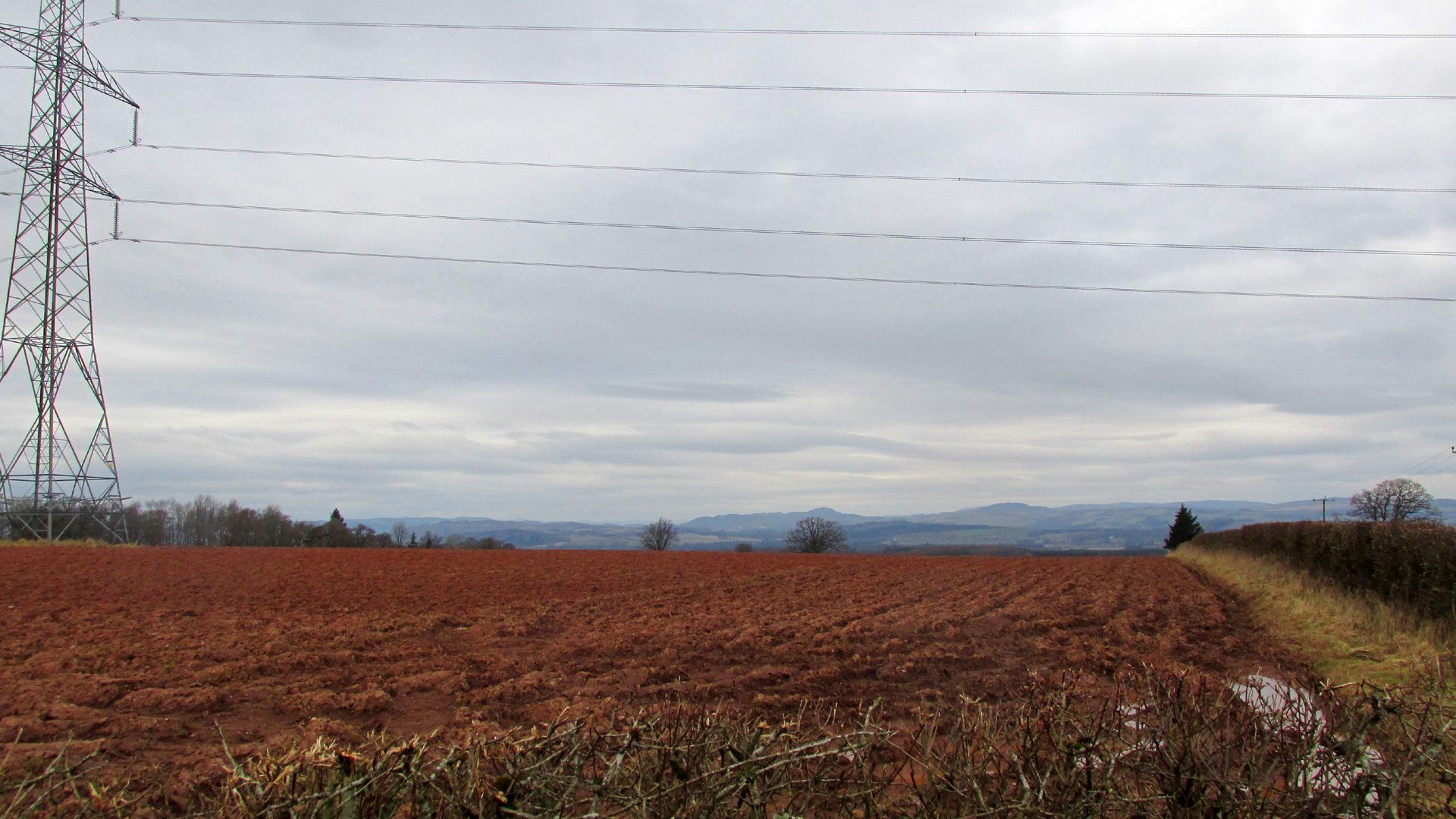
Looking north from the road the stones stood to the right of and beyond the pylon
Or as another writer puts it, they were; ‘dug around and under, and buried, in the agricultural improvement of theground’. For all we know from the written descriptions that have come down to us the stones may be prehistoric monoliths, with it seems only one of them carved. As they stood alongside the Roman road from Muthill to Kirriemuir, the moon and stars may have been cut by the Romans, or they could equally have been from the hand of a Pictish or later mediaeval mason. The field in which they stood was alternatively known as ‘Moonstone Butts’ or ‘Moonbutts’ – where the local archers practised.
Folklore
While the word ‘moonshade’ doesn’t appear in Jamieson’s Scottish Dictionary, nor the online Dictionaries of the Scots Language, the Oxford English Dictionary defines it as an obsolete word for ‘nightshade’, citing a quotation from Sir Francis Bacon’s Sylva Sylvarum of 1627:
‘The Ointment, that Witches use, is reported to be made, of the Fat of Children, digged out of their Graves; Of the juyces of Smallage, Wolfe- bane, And Cinquefoile; Mingled with the meale of fineWheat. But I suppose that the Soperiferous Medicines are likest to doe it; Which are Henbane, Hemlocke, Mandrake, Moone-Shade, Tobacco, Opium, Saffron, Poplar- Leaves.’
Given the stones are in the Perthshire witch country (the Witches Stone of Shakespeare’s Macbeth is only 2½ miles due south of here), this is nevertheless almost certainly a ‘red herring’, with the field deriving its name from the carvings on the stone. Only when we can again see the Moonshade Stones, ‘digged out of their grave’ will we be able to begin to understand them. So will there be any motivation to excavate them?
Turn right off the A93 at Cargill onto the side road by Keepers Cottage and up the hill to Gladsfield Wood at the top on your right. Park up at the top side of the Wood and walk straight along the narrow track for around 450 yards and what may be the remains of the stone will be seen between a pair of mature trees.
Archaeology & History
In 1862 the stone was described in the Ordnance Survey Name Book for Perthshire:
‘And about 150 yards from the same object [Hangie’s Well], in a north-westerly direction, there is a small Standing Stone, having the appearance of the ancient monumental standing stones.’
It seems the stone had been removed by the time Fred Coles (1909) came to see it nearly fifty years later. He told us:
“On the day of my visit the mist was so abnormally dense and confusing that it was with considerable difficulty the wood itself was identified; and as its interior is an utter wilderness of trees, shrubs, brambles, broom, wild roses and tall grass, besides being a pheasantry, it is just possible that the monolith searched for evaded my zeal. I think not, however, because, hearing a hedger at work on the Newbigging side of the wood, I made for him; and after plying him with various questions, could get no statement to the effect that he had, though living so near, ever seen any conspicuously tall Stone in the wood.
“On retracing my steps, I searched a fresh portion of the wood, and noticed one biggish block of whinstone lying on the grass in a slight hollow of the ground. It was somewhat cubical, about 2 feet 6 inches square, and fractured. This may he a portion of the former monolith, possibly; and with this dubious result I had to be content.”
In 1967 the archaeologist O.G.S. Crawford described “a sharp-edged boulder standing near the spot marked on the map,” but was not certain if it was the stone. It had no markings on it.
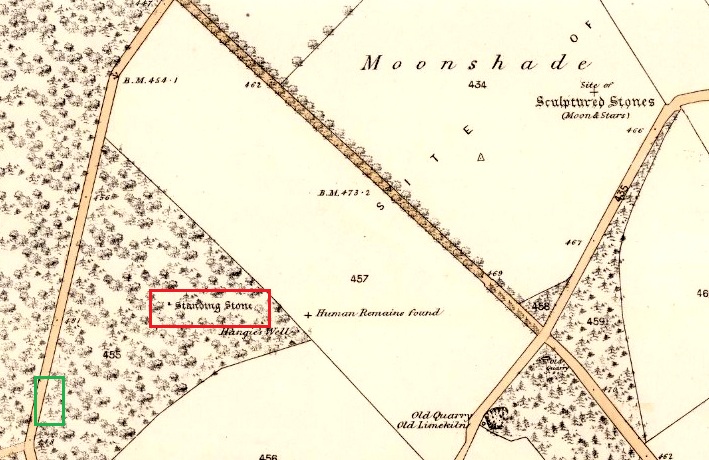
25 in OS map of 1866 showing original position of stone outlined red and position of possible remains of stone in green
Moving on to 2020, and I found the same impenetrable jungle that Coles described more than a century earlier. When a site has been destroyed I can normally take a photograph of where it once was, but not in this case. I continued westward over difficult and potentially ankle snapping terrain that had recently been replanted with conifer saplings, until I got out of the planting area to a line of mature trees next to the track through the wood.
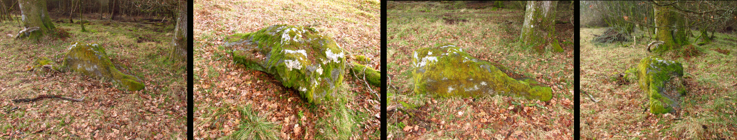
One large elongated stone presented itself that had clearly lain there for many years judging from the moss growth, a short distance away at NO 15641 35478. Could this be the top part of the standing stone, dragged from its original position some 500 feet to the north-east? It is of grey whinstone, heavily veined at the base, with white quartz and tapering to a pointed tip. It has a squarish base measuring approximately 3 feet across by at least 2 feet deep and is some 7 feet in length. It doesn’t look to be natural, so is it a likely candidate for our missing stone? Felled by a man with a hammer and chisel and dragged by a heavy horse to the edge of the field as part of the ‘improvements’, so beloved of nineteenth century landowners…
We can’t prove it is the remains of Hangie’s Stone which may, after all, still lie buried in the boscage…
The possible remains of Hangie’s Stone
The stone in its original position was next to the Roman road from Camelon via Stirling and Muthill to Kirriemuir near to the junction of a road to Inchtuthill Roman Fort, so may have once been a way marker, although it is not of Roman origin.
Standing Stone (lost): OS Grid Reference – SU 161 432
Archaeology & History
In William Stukeley’s Stonehenge, he described a number of monoliths outlying Salisbury Plain that also possessed a prehistoric pedigree. Most of them have been recorded, but this one seems to have been forgotten about — perhaps by virtue of it having fallen into the River Avon! Edgar Barclay (1895) described it in his fine survey, saying:
“In the bend of the river below the village, is a large submerged stone; only during drought is any portion of it visible above water; it can, however, in ordinary times, be dimly seen from the bank, which is of chalk, here very steep and overgrown. The country people assert that a metal ring, “turning always,” is let into its upper end. Legend relates that when the Devil brought the rocks of Stonehenge from Ireland, tied together with withes, this stone escaped from the bundle and fell into the river. Its position forbids the belief that it got fixed in the bed of the stream when its passage to Stonehenge was being attempted, for it lies immediately beneath the crest of a very steep bank, and at its most inaccessible point; as the stream sweeps against this, the water must always have been deep at this spot, the open valley would everywhere offer more favourable points for such an operation, especially would this be the case before the Avon was dyked. A boundary stone would have been placed on the brow of the hill; if the stone be a grey-wether, as report says, and as is probable, it may originally have stood on the bank, and “once upon a time”, a ring having been fixed in it, it may have been dragged into the stream to moor a ferry-boat. It lies closely midway between the stone on Bulford Down and that in Durrington fields.”
One wonders if any local people might know more about this…
References:
Barclay, Edgar, Stonehenge and its Earth-works, D. Nutt: London 1895.