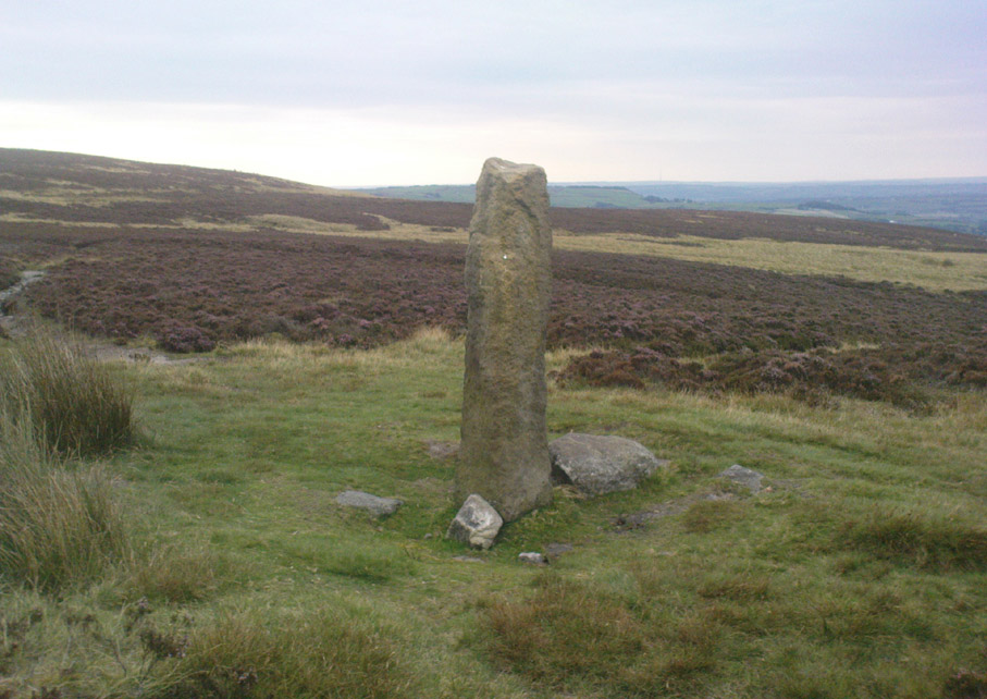
Churn Milk Joan, Midgley Moor, West Yorkshire

Standing Stone:  OS Grid Reference – SE 01974 27684

Also Known as:

  1. Saville’s Low

Getting Here

Churn Milk Joan, Midgley

From the village of Midgley, high above the A646 Halifax-to-Todmorden road, travel west along the moorland road until you reach the sharp-ish bend in the road, with steep wooded waterfall to your left and the track up to the disused quarry of Foster Clough.  Go up the Foster Clough track for 100 yards and, when you reach the gate in front of you, go over it but follow the line of the straight walling uphill by the stream-side (instead of following the path up the quarries) all the way to the top. Here you’ll see the boundary stone of  Churn Milk Joan.

Archaeology & History

The present large standing stone you see before you isn’t prehistoric.  However, the small broken piece on the ground by its side may have been its prehistoric predecessor; and there is certainly something of an archaic nature here — albeit a contentious one — as we find old cup-markings cut into its eastern face.
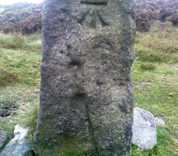
Two ‘cup-marks’ on eastern face

The upright is roughly squared and faces the cardinal points.  It was described in Mr Heginbottom’s  (1977) unpublished survey on Calderdale rock art, where he described there being a few cup-markings inscribed on its east- and south-facing edges, some of which may be prehistoric — though they would obviously have had to have been carved upon the upright stone when it still lay earth-fast.  However, we must posit the the notion (unless some of you have better ideas) that the tradition of etching cup-marks onto rocks was still occurring in this part of Yorkshire until the late Middle Ages, as this stone was, as we know from boundary records, only placed upright to mark the meeting of the three boundaries of Wadsworth, Hebden Royd and Sowerby.

Churn Milk Joan’s other name, Saville’s Low, originates from the great Saville family who owned great tracts of land across the region in the fourteenth century, possibly when the Churn Milk Joan we see today was created.  The word “lowe” may derive from the old word meaning, “moot or gathering place,” which this great stone probably served as due to its siting at the junction of the three townships.*

Folklore

In modern times the stone has become a focus for a number of local pagans and New Agers who visit and ‘use’ the site in their respective ways at certain times of the day, albeit estranged (ego-bound) from the original mythic nature of the site.

The name of the stone comes from an old legend about a milk-maid named Joan who, whilst carrying milk across the moors between Luddenden and Pecket Well, got caught in a blizzard and froze to death.  When her body was found many days later, the stone we see here today was erected to commemorate the spot where she died.  Although such a scenario is quite likely on these hills, as Andy Roberts (1992) said,

“Considering the sheer amount of sites with similar legends this explanation is unlikely to be true and we should looker deeper for the meaning behind Churn Milk Joan, to be found in its positioning in the landscape and ourindividual feelings about it.”  [see profiles for the Two Lads and the Lad o’ Crow Hill sites)

The monolith’s other title, Churnmilk Peg, is the name given to an old hag who is said to be the guardian of nut thickets.  How this female sprite came to find her abode upon these high hills is somewhat of an enigma, but it was first stated as such in an article by Andy Roberts (1989) in “Northern Earth Mysteries” magazine.  E.M. Wright (1913) noted this supernatural creature in her work on folk dialect, describing it as a West Yorkshire elemental who, along with another one known as Melsh Dick:

“are wood-demons supposed to protect soft, unripe nuts from being gathered by naughty children, the former being wont to beguile her leisure by smoking a pipe.”

Another legend of the stone tells how it is said to spin round three times on New Year’s Eve when it hears the sound of the midnight bells at St. Michael’s church (St. Michael was a dragon-slayer) at Mytholmroyd in the valley below.  Another piece of folklore tells that coins used to be left in a small hollow at the very top of the stone which, according to Haslem (1981), was “a gift to the spirit world, to bring luck” – a common folk motif.  It may equally originate from the custom of it as a plague stone.  This tradition of leaving coins atop of the stone is still perpetuated by some local folk.

Mr Haslem also made some interesting remarks about the nature of Churn Milk Joan standing as a boundary stone, representing something which stands not just as a physical boundary, but as a boundary point between this and the Other- or spirit world.  In folklore, streams and rivers commonly carry this theme.  But here on Midgley Moor, as a standing stone at the junction of three boundaries, we may be looking at the place as an omphalos: a centre point from which the manifold worlds unfold. (see Almscliffe Crags, the Ashlar Chair and the Hitching Stone)

The other motif here, of milk and snow [both white], have been speculated to represent power of the sun at midwinter, and geomantically we find the position of the stone in the landscape exemplifying this: it stands midway in the moorland scenery facing south, the direction of solar power, yet is bounded as an equinox marker from east and west.  The winter tales it has nestled around it are merely complementary occult augurs of its more wholesome elements at this point in the hills.

There is however, another much more potent element that has not been conveyed about the site and its folklore—and one which has more authenticity and primary animistic quality.  Regardless of ‘Joan’ or ‘Peg’ being the elemental preserved in the landscape title, the ‘churning’ in its name and the ‘spinning’ of the stone in myth at the end of one year and the start of the next at New Year, are folk memories of traditional creation myths that speak of the cyclical seasons endlessly perpetuated year after year after year, in what Mircea Eliade (1954) called the ‘myth of the eternal return.’  As season follows season in the folk myths of our ancestors, everything related to the natural world: a world inhabited (as it still is) by feelings and intuitions learned from an endless daily encounter, outdoors, with the streams, hills, gales, snow and fires.  Their entire cosmology, as with aboriginal people the world over, saw the cycles of the year as integral parts of their daily lives.  Here, at Churn Milk Joan with its central landscape position along an ancient boundary, the churning and turning of the year was commemorated and mythologized year after year after year; with maybe even the Milky Way being part of the ‘milk’ in its title, from which, in the shamanistic worlds that were integral to earlier society, the gods themselves emerged and came down to Earth.

References:

  1. Bennett, Paul, The Old Stones of Elmet, Capall Bann: Milverton 2001.
  2. Eliade, Mircea, The Myth of the Eternal Return, Bollingen 1954.
  3. Haslem, Michael, “Churn Milk Joan: A Boundary Stone on Midgley Moor,” in Wood and Water, 1:8, 1980.
  4. Heginbottom, J.A., “The Prehistoric Rock Art of Upper Calderdale and the Surrounding Area,” Yorkshire Archaeology Society 1977.
  5. Ogden, J.H., “A Moorland Township: Wadsworth in Ancient Times,” Proceedings of the Halifax Antiquarian Society, 1904.
  6. Robert, Andy, “Our Last Meeting,” in NEM 37, 1989.
  7. Robert, Andy, Ghosts and Legends of Yorkshire, Jarrold: Sheffield 1992.
  8. Wright, Elizabeth Mary, Rustic Speech and Folk-Lore, Oxford University Press 1913.

* The great stone at the cente of the Great Skirtful of Stones, Burley Moor, which previously stood at the centre of the Grubstones Circle, was just such a moot stone.  Upon it is carved the words “This is Rumble’s Lawe”.

© Paul Bennett, The Northern Antiquarian
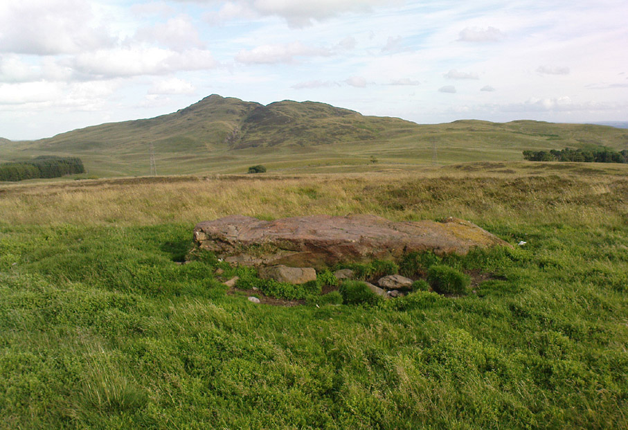

Pendreich Muir, Dunblane, Stirlingshire

Standing Stone:  OS Grid Reference – NS 81382 99686

Getting Here

The huge Pendreich Muir monolith, with Dumyat in the background

Nearly 600 yards west of the old Sheriffmuir Road (between Bridge of Allan to Greenloaning), you’re best approaching it up the zigzaggy lane from above Stirling Uni until it levels out beyond the main wooded area where the hills open up on either side of you.  There’s a little touristy parking spot further along the road, just below a small wooded bit.  Go past this and look out for the small peaked hill nearly a half-mile NW on your left.  Take whichever footpath you fancy (if you see one) and get to the top of that hill!

Archaeology & History

This is a wonderful spot, located at the highest point on this small moorland region on the western edge of the Ochil Hills.  I haven’t found too much written about this once proud, but now fallen monolith — which seems unusual considering its size, cos it’s huge!  It would have stood out and been visible for miles around.  Quite when it was felled, I cannot find.  The only info I’ve got here (Royal Commission 1963) tells:

“Lying recumbent on a grassy patch among the heather, it is a four-sided pillar measuring 13ft in length, a maximum of 4ft 6in across the wider side, and a maximum of 1ft 6in across the narrower side.”

In enquiring about the nature of this stone a few years ago, a local chap who called himself ‘Wharryburn’ wrote to say, “I believe the laid-out stone is a fallen standing stone. My grandfather was gamekeeper at Airthrey Estate and responsible for the shooting on the moor there he passed it to my father etc… It’s the local volcanic stone, not an ice-dropped erratic. There are also a few biggish stones at points around that I tried to make some sense out of a few years ago, but no luck.”

The great hill of Dumyat rises to its east; a short distance north is a megalithic stone row with its upright Wallace Stone; whilst the overgrown prehistoric cairns of Pendreich 1, 2 and 3 live on the small hillocks a few hundred yards to the south.

References:

  1. Royal Commission on the Ancient & Historical Monuments of Scotland, Stirlingshire – volume 1, HMSO: Edinburgh 1963.

© Paul Bennett, The Northern Antiquarian


North Beachmore, Muasdale, Argyll

Cup-and-Ring Standing Stone:  OS Grid Reference – NR 6928 4184

Also Known as:

  1. Canmore ID 38589
  2. Gaigean

Archaeology & History

This lovely-looking 5-foot tall standing stone, marking an old boundary line in the Muasdale parish, is a curious one with elongated cups, some of which have the appearance of natural beach-side erosion caused by molluscs — unlikely though it may be.  It first appears to have been described in an early PSAS article by Duncan Colville (1930), who told us:

“The writer was informed by the Rev. D.J. MacDonald, the minister of the parish, of the existence of this cup-marked stone forming a gatepost in the boundary wall between the arable and hill ground on the farm of Gaigean.  The gate referred to is situated on the top of a steep bank on the south side of a small stream, a short distance uphill to the east of the farm steading of Gaigean.  The front of a stone is now set an angle of about 45° to the ground facing almost southwest (105° magnetic across the face).  Underneath the stone is another boulder similar in size, with several smaller stones wedged between the two, thus preventing further inspection.”

The North Beachmore stone

Some years later when the Scottish Royal Commission (1971) lads described the site in their Kintyre survey (monument no.97), they gave a more detailed description of the cup-and-rings, saying:

“The markings consist largely of plain cups, but one cup is accompanied by a partial single ring which measures 0.11m across.  At the foot of the lower half of the stone four cups linked by broad gutters form a curious branched pattern, and a similar combination of three cups and gutters occurs in the upper half, while in two other instances a pair of cups are joined by a short straight channel to form a dumb-bell figure.  The remainder of the markings comprise twelve oblong or kidney-shaped hollows measuring up to 0.15m in length by 0.064m in breadth, and thirty-one plain cups ranging from 0.038m to 0.076m in diameter, the largest being 0.019m deep.”

References:

  1. Colville, Duncan, “Notes on the Standing Stones of Kintyre” in Proceedings of the Society of Antiquaries, Scotland, volume 64, 1929-30.
  2. Royal Commission on the Ancient & Historical Monuments of Scotland, Argyll – volume 1: Kintyre, HMSO: Edinburgh 1971.

© Paul Bennett, The Northern Antiquarian
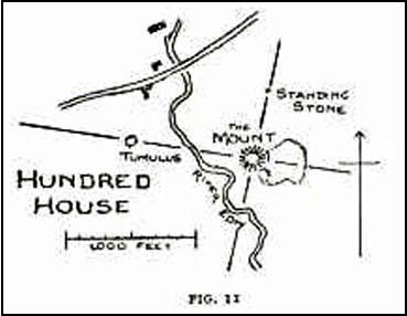

Penbont, Hundred House, Radnorshire

Standing Stone (destroyed):  OS Grid Reference – SO 117 544

Also Known as:

  1. Hundred House Standing Stone

Archaeology & History

Position of the old stone (on one of Alf’s leys)

In a field less than 200 yards north of an old medieval mound known as The Mount, the great ley-hunter Alfred Watkins (1925) described a standing stone that used to be here along one of his leys, but which, even then, had been “inexplicably blown into several pieces by a quarrymen’s charge.”

The stone was said to have originally come from an adjacent field and then moved next to yet another monolith, which was also broken up. Can any remnants of these poor fellas still to be seen anywhere nearby?  Or is it a case of yet another one bites the dust?

References:

  1. Watkins, Alfred, The Old Straight Track: Its Mounds, Beacons, Moats, Sites and Mark Stones, Methuen: London 1925.

© Paul Bennett, The Northern Antiquarian

Lipney, Blairlogie, Stirlingshire

Standing Stone:  OS Grid Reference – NS 8436 9803

Also Known as:

  1. Canmore ID 145078

Getting Here

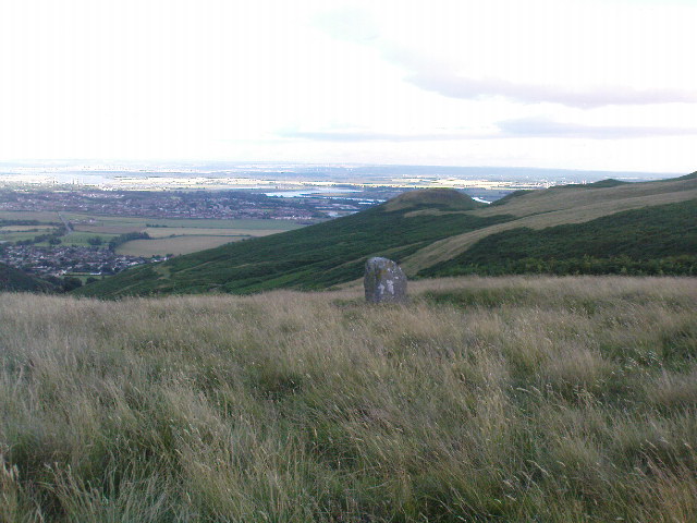
From Menstrie, walk up the path behind the post office and head up onto the hills, following the track that runs up alongside the Menstrie Burn.  After about 500 yards, crossing a stream, the path has a sort of hairpin kink and, shortly past this a smaller path leads off up into the grasslands on your left.  The standing stone can be seen up this path about 100 yards up.

Archaeology & History

The Lipney Stone

We came across this small standing stone, less than four feet high, after running and jumping down the steep eastern slope of Dumyat at some speed — or rather, Naomi came across the little thing and then told me about it after I’d run round and further down the slope towards the upper stretches of the Menstrie Burn (I was knackered!).

It’s a curious little thing inasmuch as it stands here alone, with no other companions close by; although there were a number of other stones scattering the grasslands hereabouts and other stones may await discovery.  Little seems to have been said of the site.  The Canmore record tells:

“It measures 1.1m in height, 0.7m in breadth and 0.4m in thickness, and is aligned with its long axis NE-SW. It rises with straight sides and leans to the SE.”

There are extensive remains of earthworks scattering the slopes hereby, though much of this seems medieval in nature.  Any further information about this old stone would be much appreciated!

© Paul Bennett, The Northern Antiquarian

Cornwell Stone, Salford, Oxfordshire

Standing Stone:  OS Grid References – SP 2770 2785

Getting Here

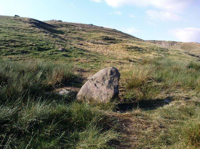
Go west along the A44 from Salford village ’til just before the crossroad with the A436. 100 yards before here there’s a small left turn, downhill, past Hollis Hill Farm and Park Farm. Before reaching Cornwell at the bottom, walk into the fields to your left and find the township boundary (on 1:25,000 OS maps), which is marked with old hedges.  It’s in here!

Archaeology & History

Walk along the line of old hedges, checking either side if it’s overgrown, until you find this well-worn three-foot tall standing stone (exact coordinate SP 2770 2785) standing in the hedgerow. It’s a cute little thing which may have marked the old boundary line, but it has a distinctly prehistoric feel and look to it, in a region where many old prehistoric remains still linger…

References:

  1. Bennett, Paul & Wilson, Tom, The Old Stones of Rollright and District, Cockley: London 1999.

© Paul Bennett, The Northern Antiquarian

White Stone, Dunblane, Stirlingshire

Standing Stone:  OS Grid Reference – NN 8063 0420

Also Known as:

  1. Glenhead
  2. MacGregor Stone
  3. NN80SW 3 (Canmore)
  4. Whittieston Stone

Getting Here

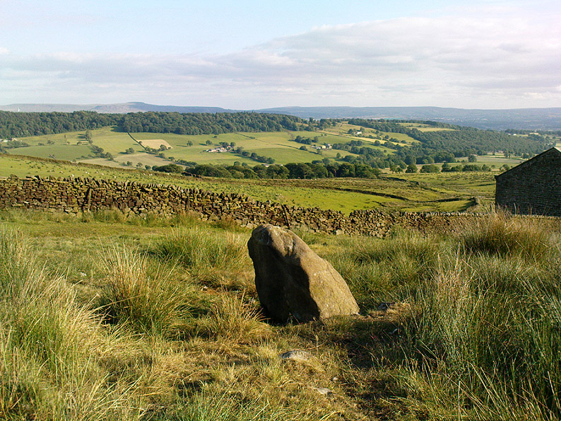
If you’re not into the walk, get the bus running NE between Dunblane and Greenloaning — the A9 — getting off at the Little Chef on the dual carriageway and cross the road, walking up the track to Upper Whiteston Farm (the owners here are very helpful).  As you walk up the track you’ll notice the large upright in the edge of the field a coupla hundred yards to your right.  That’s the one!

Archaeology & History

This is a mightily impressive site if you’re into yer megaliths!  When it was visited and measured by Mr Hutchinson (1893) in the 19th century he found it to be 9ft 4 in tall; and although it seems quite isolated at first sight, we find that there is another large stone companion laid down not far to the north of here which may have had some relationship with it .  But that aside…  There are also as many as eight cup-markings on the stone’s eastern face: one large one and seven smaller ones, in no particular order as usual!  It was these cup-marks that gave me the impression there was once a burial associated with the stone, but the archaeology records seem silent on such a matter; though folklore tradition tells another story…

Folklore

Mr Hutchinson (1893) told that the legend attached to this stone appears to be “of quite recent date.”  He said how,

“In the district the stone is known as the MacGregor Stone, and the tradition accounting for the name is to the effect that here a countryman was sacrificed by the followers of Rob Roy, when forming for the engagement on Sheriffmuir, in order to satisfy the ancient Highland superstition that first-blood was an infallible omen of success… The tradition is precise enough to state that a man of the name Dawson was seized in the adjoining hamlet of Whiteheadston (for such is the orignal name) as a whig, and therefore a foeman and proper victim.  Dawson, however, suspecting the intentions of the captors, vehemently professed himself a supporter of King James and was left off.  But another inhabitant of the hamlet not so acute or not so hypocritical, was immolated at the stone.”

Hutchinson however, doubts the accuracy of the tale and suggests that the local name of the MacGregor’s Stone derives from the fact that the monolith stands upon land once owned by the MacGregors of Balhaldies, countenancing that the stone “is of much earlier date than the MacGregors of Balhaldie or any other sept of the Children of the Mist.”  I think he’s got a point!

References:

  1. Hutchinson, A.F., “The Standing Stones of Stirling District,” in The Stirling Antiquary, volume 1, 1893.

© Paul Bennett, The Northern Antiquarian


Coffin Stone, Sabden, Lancashire

Standing Stone:  OS Grid Reference – SD 7717 3830

Getting Here

From Sabden village, walk up the Clitheroe Road towards the hairpin Nick o’ Pendle, but take the turning left 100 yards before the Nick.  Walk along the dirt-track for less than 100 yards, watching for the small upright on the right-hand side of the track. You can’t really miss it!

Archaeology & History

The Coffin Stone

To be found on the far southern flanks of Pendle Hill, the Lancashire writer and historian, John Dixon,* brought us to this little-known stone a few days back — and gave us the history of the place. (Dixon 1993)  He pointed out how it’s situated right alongside the legendary cross-Pennine prehistoric route that was labelled ‘Rombald’s Way’ by Eric Cowling. (1946): an important trackway which ran from coast to coast, allowing for the passage and transmission of flints, salt and early metals carried for barter and other uses.  What may be another standing stone is on the nearby skyline a couple of hundred yards east; and on the slopes either side of here are the prehistoric tombs of Jeppe Knave Grave and the Devil’s Apronful (amongst others).  A fine little standing stone!

Folklore

The name derives from it being a place where, in bygone days, when coffins were carried along the ancient routeway hereby, it was rested by this stone.  As John Dixon (1993) told:

“It was used to mark a resting point for coffins en route from Pendle Forest to Whalley, allowing the mourners to refresh and pray by the curative Marion well, in a time before the ‘Newchurch’ of St. Mary was established at Goldshaw Booth in 1544.”

…and from another angle

The Marion Well he mentions is more popularly known as Our Lady’s Well and can be found a hundred yards up the hillside above our Coffin Stone.  If you walk up the slope you’ll see the site emerging where a small boggy pool appears on the hillside, and the course of the small stream marked by the reeds growing down the grassy slopes.  Although it became very much a Roman Catholic practice to venerate the Virgin Mary by this old well, the ritual was of course a much older heathen one.

John has also reminded me to mention “the fossil markings on the side of the stone – some plant from a former age” which you can see curving up from the bottom of the upright.

References:

  1. Cowling, Eric T., Rombald’s Way: A Prehistory of Mid-Wharfedale, William Walker: Otley 1946.
  2. Dixon, John, Journeys through Brigantia – volume 9: The Ribble Valley, Aussteiger Publications: Barnoldswick 1993.
  3. Dixon, John, Pendle – A Mythic Landscape, Aussteiger Publications: Barnoldswick 2010.

* John is the author of many fine historical travel guides, including the Journeys through Brigantia series. See the titles in the Lancashire Bibliography and Yorkshire Bibliography for a more complete listing of all his books to date.  If you wanna buy any of his works, or make enquiries regarding them, email John at: lancashirebooks@fsmail.net – or write to him direct, at: John Dixon, Aussteiger Publications, 21 Lowergate, Clitheroe, Lancashire BB7 1AD.

© Paul Bennett, The Northern Antiquarian

Wallace’s Stone, Dunblane, Stirlingshire

Standing Stones / Stone Row:  OS Grid Reference – NN 83259 02293

Also Known as:

  1. Lairhill Stones

Getting Here

Follow the same directions as to reach the cup-marked Sheriffmuir Carving, which is just a coupla hundred yards away to the southwest.  On a clear day you can see this standing stone from the pub by the roadside, a few hundred yards away!

Archaeology & History

Wallace Stone (photo credit – James Elkington)

This is alleged to be just one standing stone in a straight line of five once-upright monoliths.  Starting at the southwestern end of this row we have the 7ft-long cup-marked Sheriffmuir Carved stone — which certainly looks as if it stood upright in the not-too-distant past — and as we move up the line we pass another that’s been split in half.  Another earthfast-looking rock is the next contender, before we reach our famous Wallace Stone, standing upright and proud on this moorland ridge.  It’s about 6ft tall and 3ft across at its widest and certainly acts as a marker for the line of stones that allegedly stood upright here.  And if we walk just a bit further up we have another big stone laid on the ground which is alleged to be a part of the same alignment.

The split stone (photo credit – James Elkington)

If it is an authentic megalithic row, it’s not included in either the Thoms’ (1990) two-volume work on the subject, nor Aubrey Burl’s (1996) compendium a few years later.  And though the alignment looks good, I’ve found ones just like this in the Pennines where we have just one upright left and then a line of other seemingly prostrate stones running dead straight either side of the singular upright (and have kept mi gob shut about ’em for sensible reasons), so I’m not too sure what to think.

But, alignment aside, the Wallace Stone itself is a damn good standing stone and well worth checking out.  It’s highly probable that other prehistoric remains still lurk, undiscovered, amidst these heaths…like the lost stone circle to be found nearby…

Folklore

A slight variation on a theme about this spot:  in both accounts the stone was named after the legendary Scottish independence fighter, Sir William Wallace.  The folklore tells that he and his fighting clans gathered here in 1297 preceeding the Battle of Stirling Bridge; whilst the variation tells that the stone here was actually erected around that time to commemorate the event.  This tale was first narrated by a local story-teller called Blind Harry and was found by local historian A.F. Hutchinson (1893) to be a case of mistaken identity!

References:

  1. Burl, Aubrey, From Carnac to Callanish: The Prehistoric Stone Rows and Avenues of Britain, Ireland and Brittany, Yale University Press 1993.
  2. Heggie, Douglas C., Megalithic science: ancient mathematics and astronomy in north-west Europe, Thames & Hudson: London 1981.
  3. Hutchinson, A.F., “The Standing Stones and other Rude Monuments of Stirling District,” in Transactions of the Stirling Natural History and Antiquarian Society, 1893.
  4. Royal Commission on the Ancient & Historical Monuments of Scotland, Archaeological Sites and Monuments of Stirling District, Central Region, Society of Antiquaries of Scotland 1979.
  5. Thom, A., Thom, A.S. & Burl, Aubrey, Stone Rows and Standing Stones – 2 volumes, B.A.R.: Oxford 1990.

Acknowledgements:  Big thanks as always to James Elkington for use of his photos in this site profile – prints of which are available from the man himself!

© Paul Bennett, The Northern Antiquarian
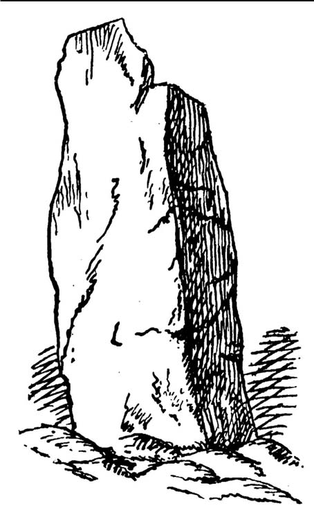

Long Stone, Adel, Leeds, West Yorkshire

Standing Stone (destroyed?):  OS Grid Reference – SE 2501 4119

Also Known as:

  1. Long Stoop

Archaeology & History

Sadly gone, this looked to be one helluvan impressive standing stone.  Described just once by the christian fruitbat Henry Simpson (1879), who told us:

“In a hedge-row, or rather stone row…is a remarkable, ancient monolith, it is thirteen feet in height; from its slender character, it does not appear to have formed one of a trilithon, but rather to have constituted a memorial of some sort, or as a beacon of some usefulness.  I can discover no barrow or earthwork near the spot.  There are remnants of a quarry close by, with a mound of earth arising therefrom, but no indications to give a clue to the meaning or use of this single pillar.  It is composed, moreover, of millstone grit, which is not to be found in the immediate neighbourhood, so it must have been brought from a distance and placed in its present position.

“Some suppose this to be a Roman stoup or pillar, designed for a landmark; but it bears no mark of Roman worksmanship.  It is crude in the extreme.”

Simpson’s 1879 drawing

There is no available folklore known to the Long Stoop, although a long straight path terminated where the monolith stood.  This path was one of many in an intricate geometric lay-out of perfect circular and dead straight tracks in the woodland immediately south of here [now built over], with four-, eight- and twelve-fold lines intersecting each other over a very large area.  It may be that this large, seemingly lost standing stone, could have been a part of the ornate grounds that were laid out here in bygone centuries, perhaps erected by the architects behind the project.

It would be damn good if locals in and around Adel could relocate this monolith — which is as likely propping up some old walling somewhere nearby — so we can make a healthy assessment as to its authenticity.  Are there any Leeds pagans who might be able to rediscover this lost standing stone?

References:

  1. Bennett, Paul, The Old Stones of Elmet, Capall Bann: Milverton 2001.
  2. Simpson, Henry Trail, Archaeologia Adelensis; or a History of the Parish of Adel, W.H. Allen: London 1879.

© Paul Bennett, The Northern Antiquarian