Simply what the term suggests: upright singular or multiple sets of stones plonked there thousands of years back (traditionally betwixt neolithic to Iron Age) for various uses. Some relate to burial; others to land-markers (tribal boundaries, etc); some may be alignment-markers (solar and lunar); others simple meeting spots (moots). They are closely related to stone circles, tombs, and many of them are outliers to such sites.
Travelling north on the Bridgemill to Fettercairn road, park at the layby just before the junction with the minor road (left) through the Forestry Commission’s Inverury Wood. Go through the gate and walk along the track to the end where it joins another track and turn right. About 300 yards along, the Hillock is in a fenced enclosure to the right, accessible over a stile.
Archaeology & History
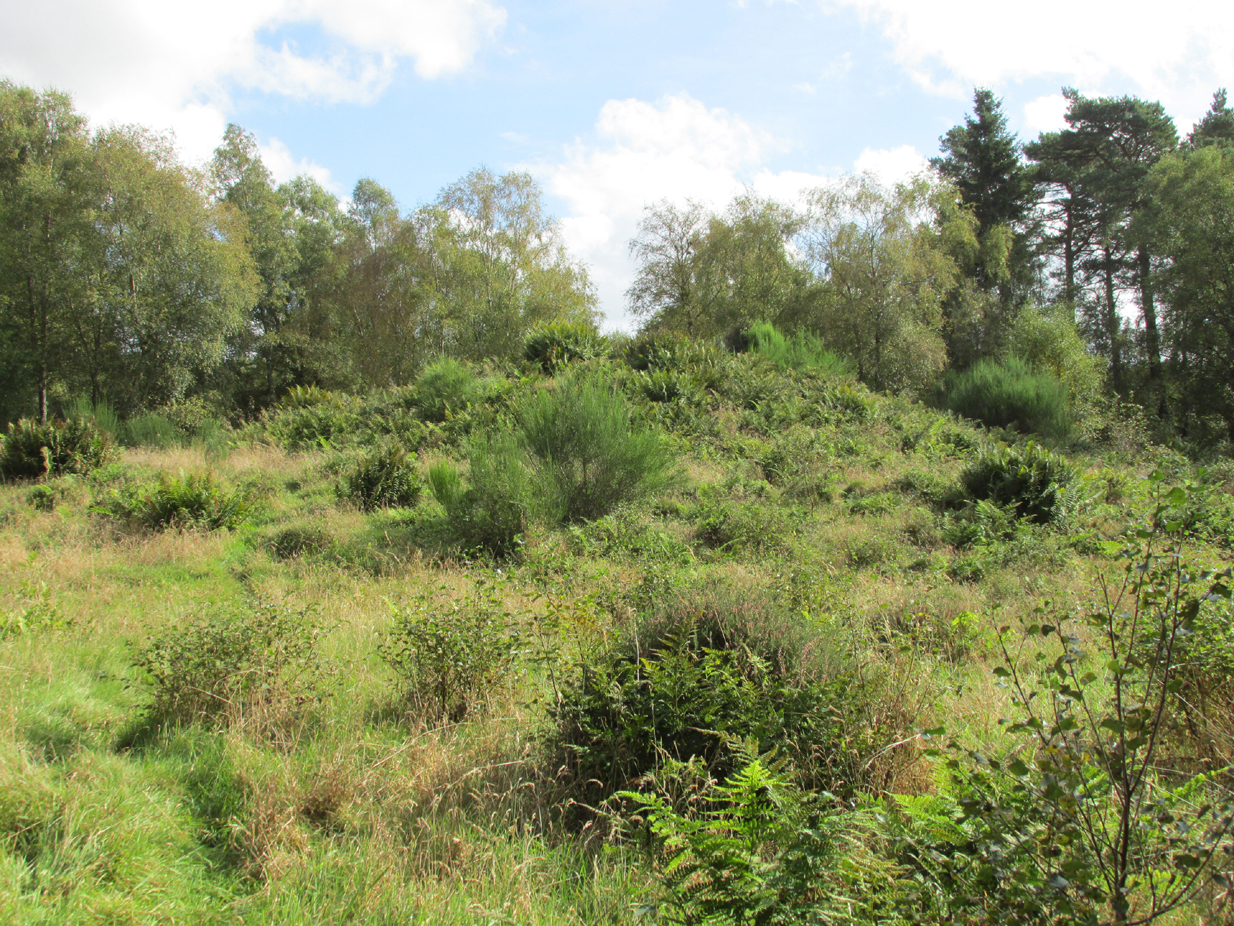
The site was not mentioned in the Statistical Accounts, nor is the origin of the name recalled, from which it is reasonable to assume that ‘witches’ (howsoever that term was interpreted in the days of persecution by the Kirk Sessions) met there. This is reinforced by there being a plot of land due west called ‘Witchfield’. The Canmore report describes the mound as being,
“situated near the edge of a low natural escarpment..measuring about 18m. in diameter and 2m. high.”
The Ordnance Survey reported in the mid-1860s that the Hillock was,
“An artificial mound….a remarkable looking object….enclosed with ornamental wire fencing, the name is well known in the district, but is not mentioned in the Statistical account nor any other document in the possession of the authorities. James Glenny, Gardener at Inglismaldie states that he assisted to open this, under directions from the Earl of Kintore, about Seven years ago, and that after clearing away the top soil there were found several stone coffins containing human bones and a clay urn containing what appeared to be calcined human bones….”
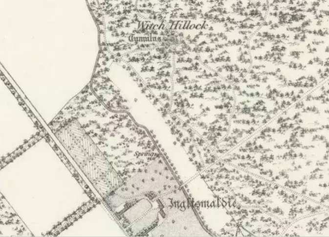
The site shown at the top of the 1865 6″ OS Map.The Hillock with 3 stones in the foreground
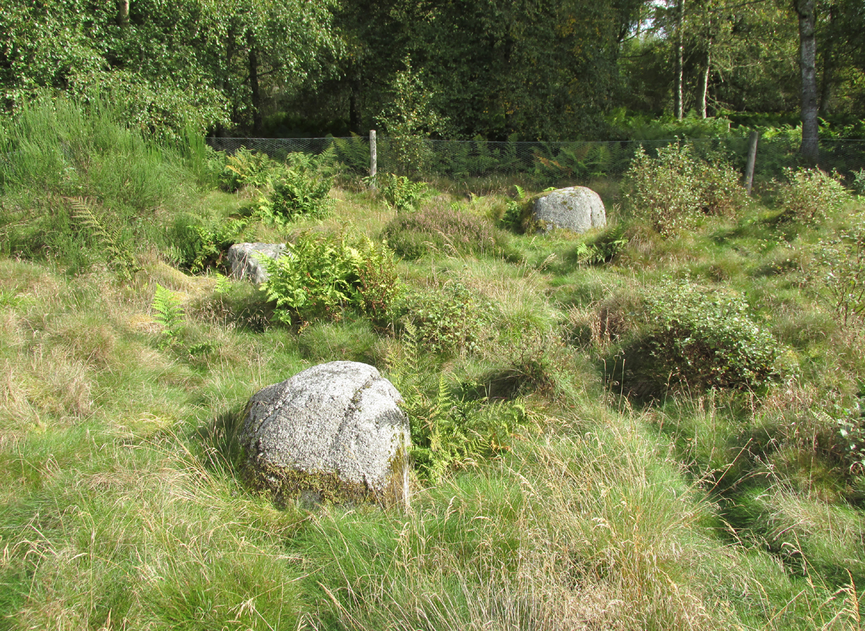
Another remarkable feature of the Hillock enclosure is an arc of three large earth fast boulders to the north-west of the mound. It has the appearance of being an incomplete, possibly four poster circle. The stones are not listed by Aubrey Burl (2000) as being part of a circle, and if indeed it was a circle there doesn’t seem to be any evidence of the fourth stone, which would have been positioned nearest to the Hillock. Unless the Hillock was imagined to be the ‘missing’ fourth stone.
Three stones – once part of a circle?
A ‘well’ is shown on the modern OS map in the corner of the enclosure nearest the stile, but there was no evidence of this on the day of my visit.
Despite its rather remote location, it was noticeable by the well trodden state of the long grass on the day of my visit that the site receives quite a few visitors – a venue still for witches?
References:
Burl, Aubrey, The Stone Circles of Britain, Ireland and Brittany, Yale University Press 2000.
Royal Commission on the Ancient and Historical Monuments of Scotland, The Archaeological Sites & Monuments of South Kincardine, Kincardine and Deeside District, HMSO: Edinburgh 1982.
Take the A822 road south out of Crieff and less than half a mile down, in a field on the east side of the road is the giant solitary standing stone of Dargill. On the opposite side of the road from here (roughly) is a small country lane. Go along here and past the third field on your left, park up. Look down the fields for a coupla hundred yards and you’ll see the standing stone. Make your way there by following the field-edges.
Archaeology & History
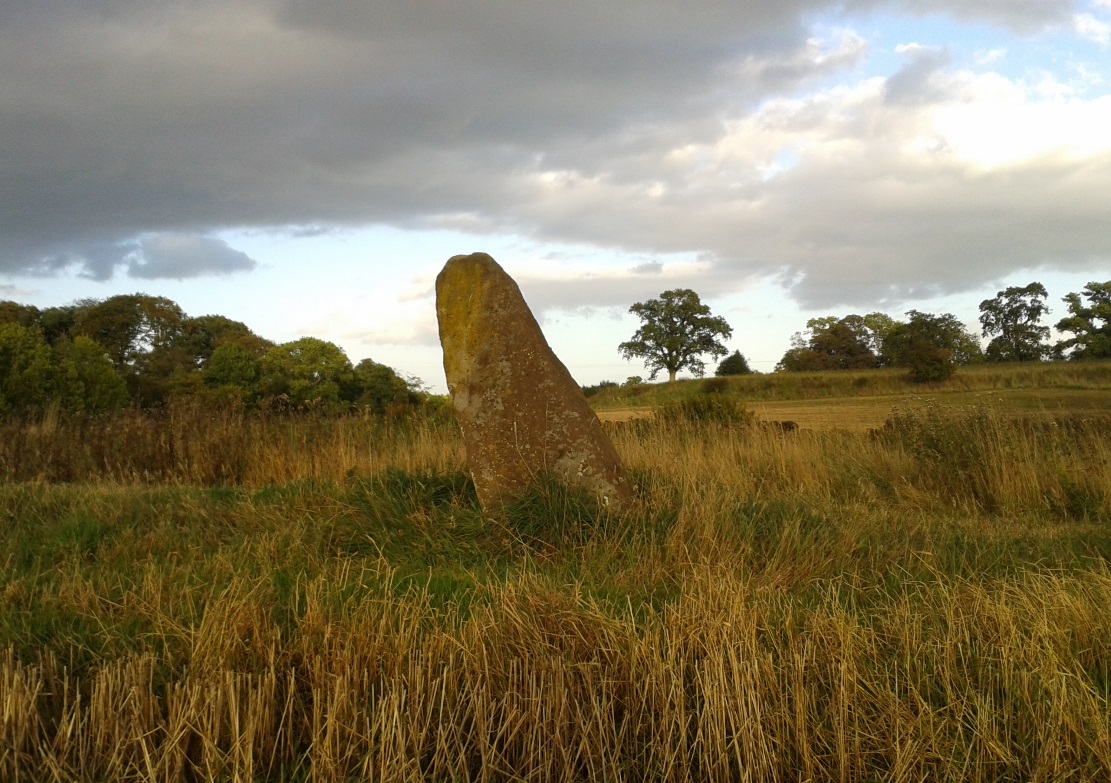
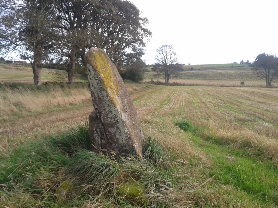
Concraig stone, near Crieff
Closer to the larger town of Crieff than it is to the village of Muthill, this seven-foot tall standing stone, leaning at an angle to the north and with a small scatter of stones around its base, stands alone near the side of the field, feeling as if others once lived close by. It’s set within a distinctly nurturing landscape, enclosed all round instead of shouting out to the hills, with that nourishing female quality, less commonly found than those stones on the high open moors. The only real ‘opening’ into a wider landscape here was mentioned by the local writer Andrew Finlayson (2010), “to the distant east.” Whether this possessed any astronomical-calendrical importance hasn’t yet been explored.
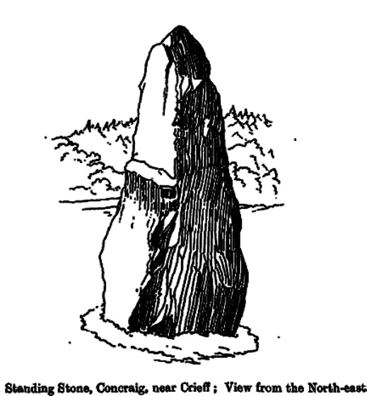
Concraig, looking southFred Coles 1911 sketch
The stone was first highlighted on the 1863 Ordnance Survey map—and described in their Name Book as “a large upright Stone adjacent to and South-east of Broadley about 8 feet high and traditionally said to be either the remains of a Druidical Temple or in some way associated with the Druidical period”—but since then it hasn’t fared very well in antiquarian tomes. Fred Coles (1911), as usual, noted it in one of his Perthshire surveys, but could find very little information from local people about the place, simply telling us that,
“in an open field about 300 yards to the north-west of Concraig, there stands this irregularly four-sided block of conglomerate schist… The stone measures 9 feet 3 inches round the base and stands 7 feet 3 inches in height. About halfway up its eastern face it has been broken so as to leave a very distinct ledge.”
What appears to be cup-markings on the southern-face of the stone are just Nature’s handiwork.
Take the same directions as if you’re visiting any of the upper Ballochraggan petroglyphs, but 100 yards before the carvings, out in the open on the grasslands, below the reach of the forest, you’ll see the leaning stone if you wander about. You can’t really miss it!
Archaeology & History
Not included in any of the Canmore, Royal Commission or Ordnance Survey records, this standing stone appears to have eluded official records until now. Found close to the petroglyph-rich arena of the Ballochraggan complex, with attendant tombs to the east, there is the possibility that this large leaning stone was itself, once, a part of a long-gone cairn, as Paul Hornby suggested. The small cluster of stones around its base certainly adds to that idea (similar to the incredible Dunruchan cluster, more than 17 miles (28km) northeast).
The stone leans at a considerable angle from a previously upright position. When standing it would have been nearly five-feet tall and measures nearly as wide. The stone is roughly triangular in shape, above ground. What appear to be two faint cup marks on its topmost surface are very probably due to conglomerate rock erosion and not the handiwork of humans.
From the old cross in the middle of the village, walk along the A820 Balkerach Street main road (NOT down George Street) until you reach Station Wynd on your right. Walk up here for 100 yards towards the new housing estate (don’t buy these places – they’re dreadful quality beneath the veneers) and there, on a small grassy rise on the left just before the car park, stands our stone!
Archaeology & History
This little-known monolith on the northern edge of little Doune village, was recently moved a short distance from its original position thanks to another one of those sad Barratt housing estates being built here; but at least it has received protection with the surrounding fence and notice board telling its brief history and folklore (better than being destroyed I s’ppose).
Stone marked on 1866 OS map
Standing less than five feet tall, local lore tells that it has been moved around close to this spot several times in the last couple of centuries. Although not mentioned in Hutchinson’s (1893) essay on local megaliths, the stone was highlighted on the 1866 Ordnance Survey of Doune, where the non-antiquated lettering showed how it was thought to be Roman in origin, not prehistoric.
Folklore
Trysting Stane, looking NE
The name of the stone comes from it being used as a place where deeds were sworn, with the stone as witness to the words proclaimed by both parties (implying a living presence, or animistic formula of great age). This activity was continued in the local ‘trysts’ or cattle fairs held a mile away, where buyers swore the sale of cattle at this stone—again with the stone being ‘witness’ to the spoken deals. It was also used as a counter where gold was exchanged for cattle bought and sold during the Michaelmas and Martinmas Fairs. Sue Harvey (2006) told that this standing stone,
“was called the Devil’s Head and was used during past Doune fairs to count gold on when cattle were being bought and sold.”
In local newspaper accounts from the 1950s, local historian Moray S. Mackay (1984) told how the children of the village used to gather round the stone, holding hands, and sing,
Olie Olie, peep, peep, peep,
Here’s the man with the cloven feet,
Here’s his head, but where’s his feet?
Olie Olie, peep, peep, peep.
Notice board telling its tale…Looking at the stone on its rise
This implies the stone once possessed a myth relating to a petrified ancestral deity of animistic (pre-christian) origin, but as yet we have found no additional information allowing us a confirmation of this probability. A correlate of this theme—i.e., of the stone being the head of a deity—is found in West Yorkshire (amongst many other places), where one of the little known Cuckoo Stones was once known to be a local giant until a hero-figure appeared and cut off his head, leaving only his body which was then turned to stone. Mircea Eliade (1958; 1963) cites examples of animistic religious rites and events explaining this early petrification formula via creation myths, etc. (we find very clear evidences of animistic worldviews and practices still prevailing in the mountains just a few miles north and west, still enacted by local people)
Folklore also alleged that the stone was Roman in nature, but neither archaeology nor the architectural form of the stone implies this. Roman stones were cut and dressed—unlike the traditional looking Bronze Age, rough, uncut fella standing here.
References:
Eliade, Mircea, Patterns in Comparative Religion, Sheed & Ward: London 1958.
Eliade, Mircea, Myth and Reality, Harper & Row: San Francisco 1963.
Harvey, Sue, Doune and Deanston, Kilmadock Development Centre 2006.
Hutchinson, A.F., “The Standing Stones of Stirling District,” in The Stirling Antiquary, volume 1, 1893.
The easiest way to find this is by going along the B9113 road that runs from the east side of Forfar, out to Montreathmont Forest. Along this road, pass the Rescobie Loch and keep going for another mile or so, until you hit the small crossroads. Go left here as if you’re going to Aberlemno. Barely 100 yards up, opposite the newly-built Westerton house, the standing stone is on the rise in the field.
Archaeology & History
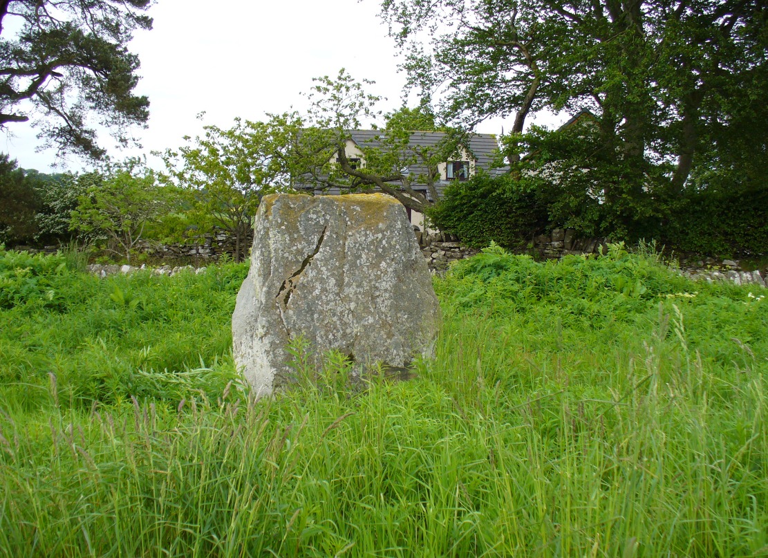
The carved west-facing side
A truly fascinating heathen stone in a parish full of Pictish and early christian remains, with the faint remains of an intriguing carving that can still, thankfully, be discerned on the southwestern face of the upright….amongst other things…
Marked as a singular stone after the Ordnance Survey lads visited here in 1901, early mentions of the site are very scant indeed. In Sir James Simpson’s (1866; 1867) early masterpiece on prehistoric rock art, in which he named the place as the “Circle of Turin,” he related how his friend and associate Dr Wyse told him how this stone “once formed one of a fine circle of boulder stones at Nether Turin,” but said little more. (Simpson was the vice president of the Society of Antiquaries of Scotland, a professor of medicine, as well as being one of Queen Victoria’s chief physicians.) The “Dr Wyse” in question was very probably Thomas Alexander Wise, M.D., who wrote the little-known but informative and extravagent analysis of prehistoric sites and their folklore in Scotland called A History of Paganism in Caledonia (1884). Therein he told us:
“At Turin, in Forfarshire, there is a large boulder which had formed one of the stones in a circle. On the flat top are several cups arranged irregularly, and without any enclosing circles. This boulder stone is on the NW face of the circle. The other side was towards the SE, facing the rising sun.”
As a result of these early references the site is listed and documented, correctly, as a “stone circle” in Aubrey Burl’s (2000) magnum opus. We do not have the information to hand about who was responsible for the circle’s desctruction—but it was likely done by the usual self-righteous industrialists or christians. It is a puzzle therefore, why Barclay & Halliday (1982) sought to reject an earlier “megalithic ring” status as mentioned by Sir James and Dr Wise, with little more than a flippant dismissal in their short note on the Westerton stone. Unless those two writers can offer vital evidence that can prove that the Westerton standing stone was not part of a megalithic ring, we can of course safely dismiss their unsubstantiated claim.
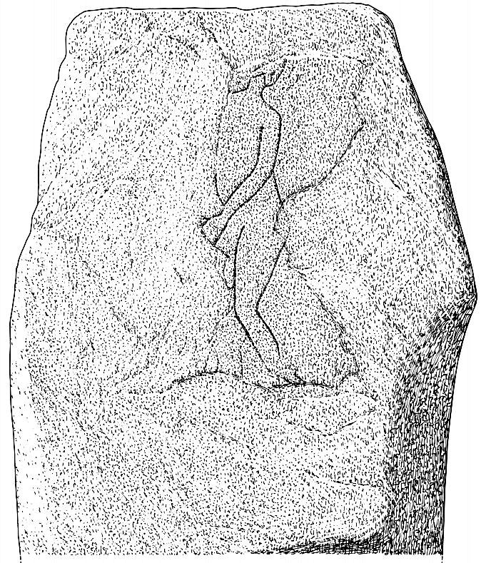
Despite this however, they do give us an intriguing description of a curious carving, faintly visible, of an upright male figure etched onto the west side of this standing stone. The carving has unfortunately been damaged—probably by intruding christians or puritans of some sad form. You’ll see why I’m blaming them in a minute! In their short account of the carving, Barclay & Halliday (1982) state:
“Much of the original surface of the SW face of the stone has scaled off, but, on the surviving portion, there is a part of a human figure…apparently naked, outlined by grooves, measuring between 5mm and 15mm in breadth and up to 7mm in depth. Of the head, only the lower part of the jaw and neck can be identified, and a second groove at the back of the neck probably represents hair or some form of head-covering. The left arm passes across the body into the lap and the arch of the back is shown by a groove which detaches itself from the upper part of the arm. The left leg is bent at the knee and is lost below mid-calf; from mid-calf to jaw is a distance of some 0.85m”
In interpreting this carving the authors make a shallow, if not poor attempt to describe what he may be doing, saying:
“The figure is viewed from its left side and is turned slightly towards the observer. The position of the left arm and leg may be compared with those of a fighting figure depicted on the Shandwick Stone, Easter Ross…but they may also reflect a riding posture; no trace of a mount, however, has survived.”
Damaged carving of a man doing summat with his cock!
Well – that is intriguing. But we have to recognise that our authors work for the Royal Commission, which may have effected their eyes and certainly their minds—as everyone else sees something not drawn out of Rorscharch’s famous psychology test! When I put the drawing you can see here (left) onto various internet archaeology group pages (including the Prehistoric Society, etc) the response was virtually unanimous, with some comical variants on what the carved man is doing — i.e., masturbating, or at least committing some sort of sexual act, possibly with another creature where the rock has been hacked away by the vandals. But a sexual act it is! Although such designs are rare in Britain, they are found in prehistoric rock art and later architectural carvings in most cultures on Earth. The nearest and most extravagant examples of such sexual acts can be found in the Scandinavian countries, where fertility images are profuse, often in tandem with typical prehistoric cup-and-ring designs. (see Coles 2005; Gelling & Davidson 1969, etc)
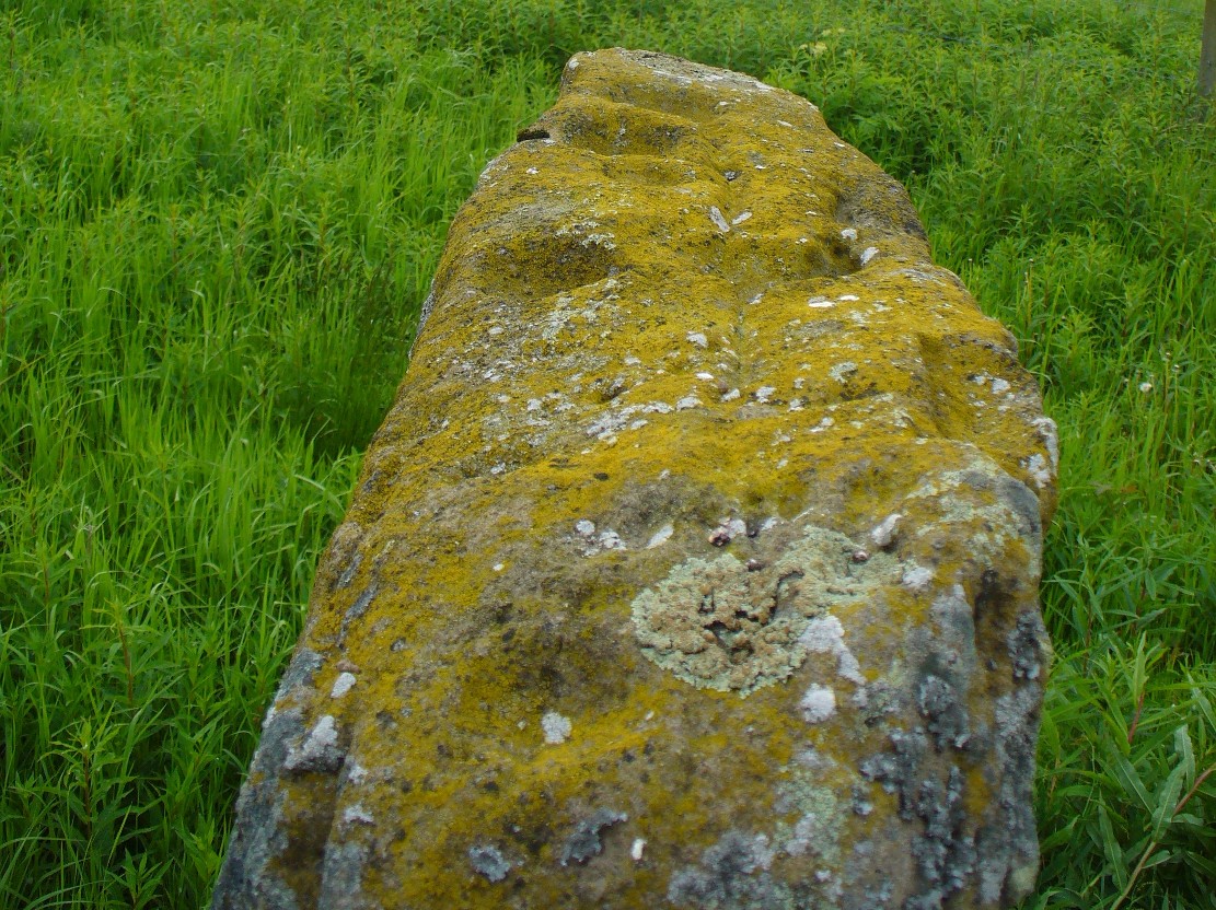
Line of cup-marks on top of stone
…And, on the very top of the stone, running along its near-horizontal surface, a line of six cup-markings are clearly visible. Intrusions of natural geophysical scars are also there, but the cup-marks are quite distinct from Nature’s wear, all on the west side of the natural cut running along the top. These cup-marks were first mentioned in Simpson’s (1866; 1867) early tome, where he told how his “esteemed friend Dr Wyse discovered ‘several carefully excavated cavities upon its top in groups, without circles.'” Whether these neolithic to Bronze Age elements had any association with the later Pictish-style wanking fella (fertility?) is impossible to know, sadly…
References:
Barclay, G.J. & Halliday, S.P., “A Rock Carving from Westerton, Angus District,” in Proceedings of the Society of Antiquaries, Scotland, volume 112, 1982.
Burl, Aubrey, The Stone Circles of Britain, Ireland and Brittany, Yale University Press 2000.
Coles, John, Shadows of a Northern Past, Oxbow: Oxford 2005.
Gelling, Peter & Davidson, Hilda Ellis, The Chariot of the Sun and other Rites and Symbols of the Northern Bronze Age, J.M. Dent: London 1969.
Sherriff, John R., “Prehistoric Rock Carvings in Angus,” in Tayside & Fife Archaeological Journal, volume 1, 1995.
Simpson, James, Archaic Sculpturings of Cups, Circles, etc., Upon Stones and Rocks in Scotland, England and other Countries, Edmonston & Douglas: Edinburgh 1867.
Wise, Thomas A., History of Paganism in Caledonia, Trubner: London 1884.
Various ways to get here: from Bathgate either take the Drumcross Road eastwards and up, or north up the Puir Wife’s Brae till you reach the crossroads where, upon the hillock north, you’ll see the old stone standing on the ridge. If you come down from Cairnpapple Hill (as most visitors are likely to do), go south for more than a mile and keep your eyes peeled in the fields to your right, shortly before the staggered crossroad. You can’t really miss it.
Archaeology & History
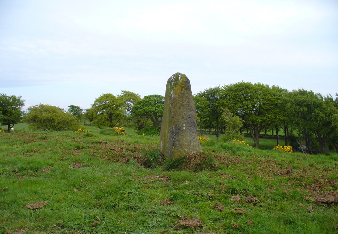
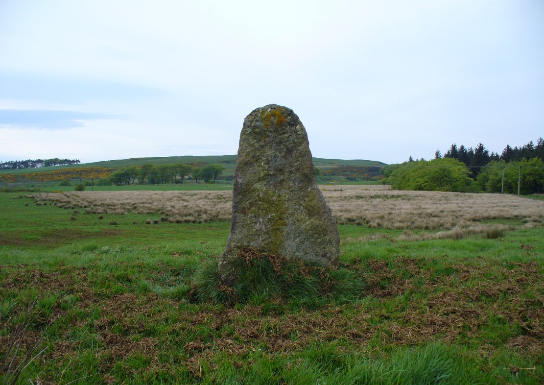
Gala Braes standing stone
About a mile south of the superb Cairnpapple Hill, in a well-manured field at the edge of a small ridge with a vast view to the south and west, this now-solitary standing stone lives quietly and alone, gazing over its old landscape. Standing about 5½ feet tall, it seems as if the monolith has been split along its southern side at some time in the not-too-distant past, leaving a damaged wedge-shaped monolith, with one very thin eastern edge and a wider western side. The stone itself was erected to align roughly north-south-east-west.
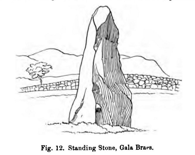
The monolith was first shown on the 1854 Ordnance Survey map of the region, along with its fallen companion (Gala Braes 2) nearly 75 yards to the west, but descriptions of the place by antiquarians are scarce. Not until Fred Coles (1903) visited here did we gain a decent account. He wrote:
“I examined this site in August 1902. It is about a mile to the east of Bathgate, and occupies the summit of a ridge extending some 300 feet westwards of the byroad that branches off due N, near the farm of Clinkingstane. The ridge is about 850 feet above sea-level. On reaching it, I found but one Standing Stone,—a rough whinstone boulder, split very unevenly, and jagged on the south side, very smooth on the two shorter sides, and girthing at the base 10 feet 5 inches. The longest edge trends WNW and ESE. It stands 5 feet 3 inches high and occupies the highest spot on the ridge.”
Whilst Mr Coles was pottering about, the courteous local farmer approached him and they began chatting about the old place—as tends to happen more than often in olde Scotland. When he,
“…asked if any digging had ever been made at either of these stones, Mr Carlaw replied that many years ago an old Bathgate worthy known as “The Apostle” persuaded his (Carlaw’s) father to dig at the base of the upper Standing Stone (the one at present erect), and they found human bones. The farm of Gala Braes has been in the tenancy of a Carlaw for upwards of a century.”
Whatever became of the old bones isn’t known. A few years later, the Royal Commission (1929) lads bimbled over to check the place out and found that it was still very much as Coles had described more than twenty years earlier, but added, “it bears no trace of sculpture.” This has since changed. Faint outlines of lettering, seemingly only a hundred years old perhaps, have been etched onto its northern face. As for the etymology of this place, Coles (1903) suggested:
“Assuming, however, that the bones found at the upper Stone were human, and taking cognisance of the fact that throughout Scotland there are many knowes, hills, hillocks and laws which are distinguished by the epithet Gallow or Gala, and that in or at many of these human remains and interments (some of them prehistoric) have been discovered, we may place this site on the Gala Braes of Bathgate in the same general group.”
Gala Braes, with Cairnpapple Hill to rearFred Coles’ 1903 drawing
Curiously he makes no mention of the nearby ‘Clinkingstane’ a few hundred yards east: an etymological curiosity that Angus MacDonald (1941) thought may have derived from a “knocking stone”; but is a word with hosts of dialect meanings, making it difficult to define with any real certainty (at the moment anyway). Just past the Clinkingstane we had the “cross on the ridge” of Drumcross—on the same ridge as our standing stones—which may well have been an attempt to keep people away from our older, more authentic heathen heritage.
The late great Alexander Thom (1990:2:341) also visited the site, but despite its impressive landscape setting and relative proximity to Gala Braes 2, he could find no astronomical orientations here. For Thom, that’s a feat in itself!
Along the A822 road between Crieff and Muthill, take the small western country lane just as you’re coming out of Muthill. Nearly 2 miles on, take the turn to the right, and then 100 yards or so from there turn sharp left. Keep along this country lane for about a mile till you reach the third track on your left. Walk down the track and you’ll see the standing stones in the field on your left. A gate into the field is by the house.
Archaeology & History
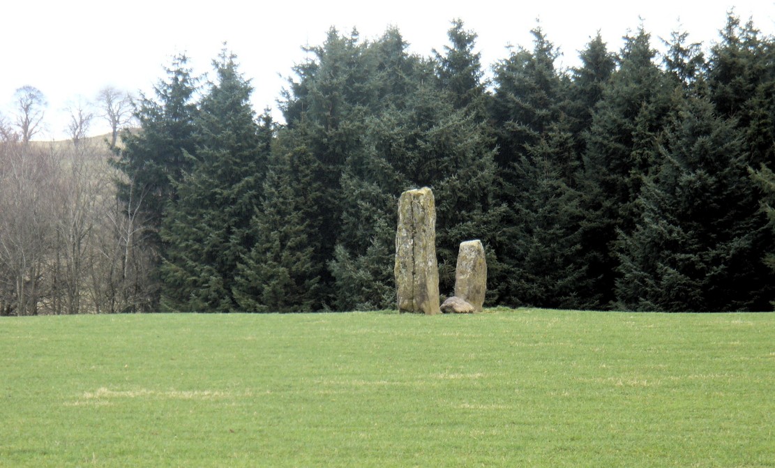
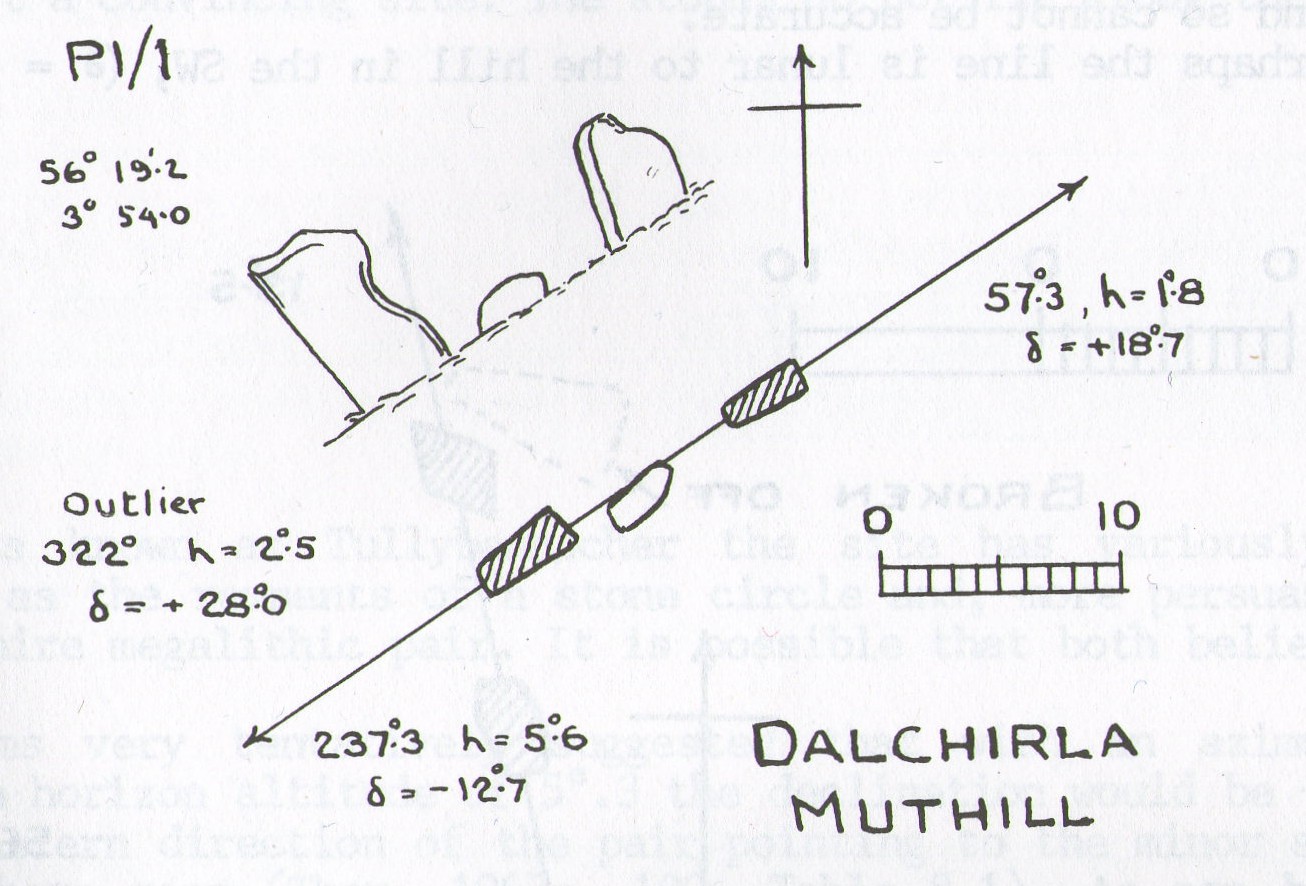
A fascinating pair of relatively large standing stones 317 yards (289.5m) SSE of the tall singular monolith of Dalchira North in the adjacent field. Traditionally said to have once been part of s stone circle, it was marked as such when the Ordnance Survey lads came here in 1863, but there is very little evidence of such a megalithic ring today—and even the small stone lying in between the two uprights is probably a more recent addition to the site. It certainly wasn’t mentioned by Fred Coles (1911) when he came here, who gave only a brief description of the place.
Dalchira East & the skyline notch of Lurgan HillDalchira, looking east
The stones were included in Margaret Stewart’s (1968) list of megalithic pairings as measuring 7ft 6in x 4ft 3in x 2ft and 4ft 3in x 3ft 6in x 1ft respectively, and 8ft apart. There is a small stone laid down in between them which has cup-marks on it, but these indentations are natural nodules in conglomerate rock. But the measurements and angles of Dalchira East were examined by the late great Alexander Thom (1967; 1990) who thought they had been positioned specifically to observe and predict lunar movements across the sky, saying that the alignment of these stones “shows the declination of the Moon rising at the minor standstill.” He may have been right.
Thom’s geometry of Dalchirla
In Aubrey Burl’s notes to Thom (1990) he told that the size and shapes of these stones “have been interpreted as anthropomorphic, the taller, or alternatively the more pointed , usually at the west, being the male, the lower or flat-topped he female.” He subsequently included this site in his own work on megalithic stone rows (Burl 1993), without further comment.
Tis a peculiar site inasmuch there doesn’t seem to be much ‘feeling’ to the place. I’m sure the site is gonna have its days, but more than likely the neat and tidy farmed theatre has subsumed the genius loci to all but the most auspicious of times—most likely generated when the pull of the Moon still tugs at any geomagnetic background memory… Still, it’s definitely worth looking at.
References:
Burl, Aubrey, From Carnac to Callanish, Yale University Press 1993.
Coles, Fred, “Report on Stone Circles Surveyed in Perthshire, Principally Strathearn” in Proceedings of the Society of Antiquaries, Scotland, volume 45, 1911.
Heggie, Douglas C., Megalithic Science: Ancient Mathematics and Astronomy in Northwest Europe, Thames & Hudson: London 1981.
Stewart, Margaret E.C., “Excavation of a Setting of Standing Stones at Lundin Farm near Aberfedly, Perthshire,” in Proceedings of the Society of Antiquaries, Scotland, volume 98, 1966.
Thom, Alexander, Megalithic Sites in Britain, Oxford University Press 1967.
Thom, A., Thom, A.S. & Burl, Aubrey, Stone Rows and Standing Stones – 2 volumes, BAR: Oxford 1990.
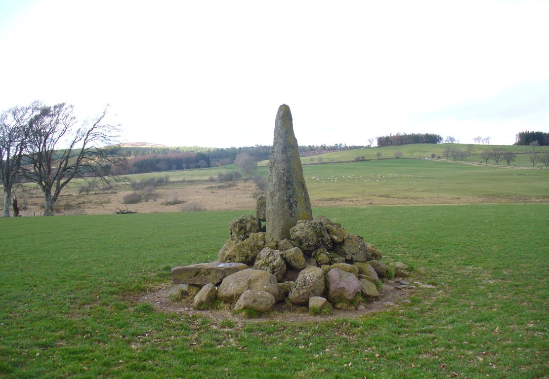
Along the A822 road between Crieff and Muthill, take the small western country lane just as you’re coming out of Muthill. Nearly 2 miles on, take the turn to the right, and then 100 yards or so from there turn sharp left. Keep along this gorgeous country lane for about a mile till you reach the third track on your left and park up. Walk down the track and you’ll see the standingh stone in the field on your right. Go all the way to the bottom where the farm is and go through the gate into the field.
Archaeology & History
The slim end of the wedge
Less than 2 miles southeast of the megalithic titan of Dunruchan A, we find a slightly smaller monolith positioned on lower ground and humbled by a more manicured landscape close to the farmhouse. But it’s still a big fella, albeit hemmed in by a mass of field clearance rocks piled up and around the base (two of which have odd carvings on them). The stone is about ten-feet tell, being very slim on its north-south side and much wider on its east-west face. For some reason I got the impression that the stone wasn’t standing in its original position; though in searching through my megalith library for further information on the site, l found that very little has been written about it. The earliest literary evidence comes, as usual, from Fred Coles (1911), who simply told us:
“In a field south of Machany Water and NE of Dalchirla farm-steading 260 yards, there stands this tall and striking monolith… In essential features this stone much resembles most of the great schistose blocks which characterize the main portion of the Strathearn area; but it tapers upwards to a very thin and narrow summit that rather distinguishes it from its fellows. It stands 9 feet 4 inches above ground, and girths at the base 7 feet 11 inches. It is set with its longer axis due north and south. Around its base there are several large masses of stone—not earthfast—amid a conglomeration of smaller pieces evidently cleared off the field.”
Fred Coles’ 1911 drawing
The prehistoric cairn of Torlum to the north may have had some significance to the setting of the stone, but without excavation and details of its original site, we’re just grasping at straws when it comes to evaluating any potential geomancy or landscape relationships—with the megalithic stone row in the next field perhaps being an exception!
The moorlands above here, stretching for many a mile, is apparently lacking in any prehistoric remains if you listen to the official records. But with the Dunruchan megalithic complex only two miles away and the once-giant tomb of Cairnwochel over the southeastern horizon, we know that cannot be possible… Watch this space!
References:
Coles, Fred, “Report on Stone Circles Surveyed in Perthshire, Principally Strathearn” in Proceedings of the Society of Antiquaries, Scotland, volume 45, 1911.
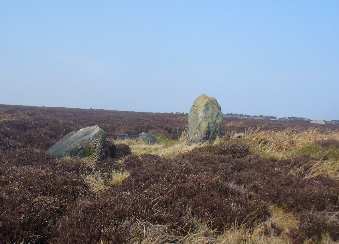
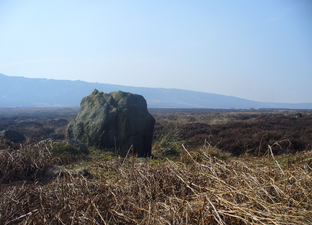
From Burley-in-Wharfedale train station, take the road uphill to the moors, turning right at the top, until you hit the bend where the stream and rocky valley of Coldstone Beck appears. Walk up the right-hand (west) side of the beck until the moorland levels out. Walk along the footpath above Stead Crag for a coupla hundred yards, keeping your eyes peeled for the largest upright stone in the heather about 50 yards into the moors. The other way is to get to Woofa Bank Enclosure and keep walking east through the heather for a coupla hundred yards till you see the tallest upright stone in the heather.
Archaeology & History
Apart from my own short entry about this site in The Old Stones of Elmet, we have no archaeological account of this standing stone, less than four feet tall and nearly as wide at its maximum, living in a landscape renowned for its excess of neolithic and Bronze Age remains. For those of us who love our megaliths it’s nothing special — but at the same time it’s worth looking at, if only because of the other mass of prehistoric remains close by. It received its name from the adjacent Coldstone Beck a short distance to the east, whose etymology isn’t clear.
Cold Stone, looking eastGazing into a hazy SW
Although we know that many of the sites on this ridge are prehistoric in origin (incredibly some of it still aint registered by those who get paid to do such things), we also need to take into consideration that this site may have been effected by the early industrialists who also made their mark on this section of the moor: they have scarred some cup-and-rings along here, destroyed other remains and left incisions on some rocks which could easily be mistaken as ancient. There is also the possibility that this upright and its adjacent stones were once part of a cairn. If evidence comes to light that the Cold Stone is more recent, we will of course amend this site entry.
Folklore
A number of Cold Stones are found scattered across upland Britain, in the form of crags or solitary stones. In North Yorkshire and beyond, the name is sometimes a corruption of a Call Stone, i.e., a site where village matters were called out prior to the institution of a bell-man. The old Market Cross in Kendal village, also known as the Cold Stone was where village notices were proclaimed.
References:
Bennett, Paul, The Old Stones of Elmet, Capall Bann: Chieveley 2001.
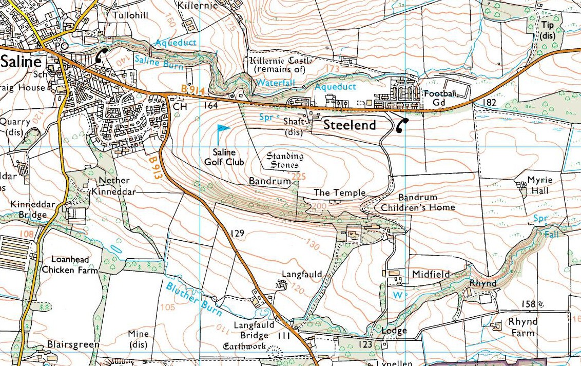
Go east on the B913 through Saline for a mile till you reach Steelend. Across the road from the houses there’s a dirt-track running uphill (south) into the fields. When you’re near the top, turn west into the fields, following the straight line of fencing towards the small clump of trees on the skyline. Near the top, a few hundred yards along you’ll see the large fat stone up against the wall. But keep walking east and another stone appears before your eyes!
Archaeology & History
The big fella, by the gate
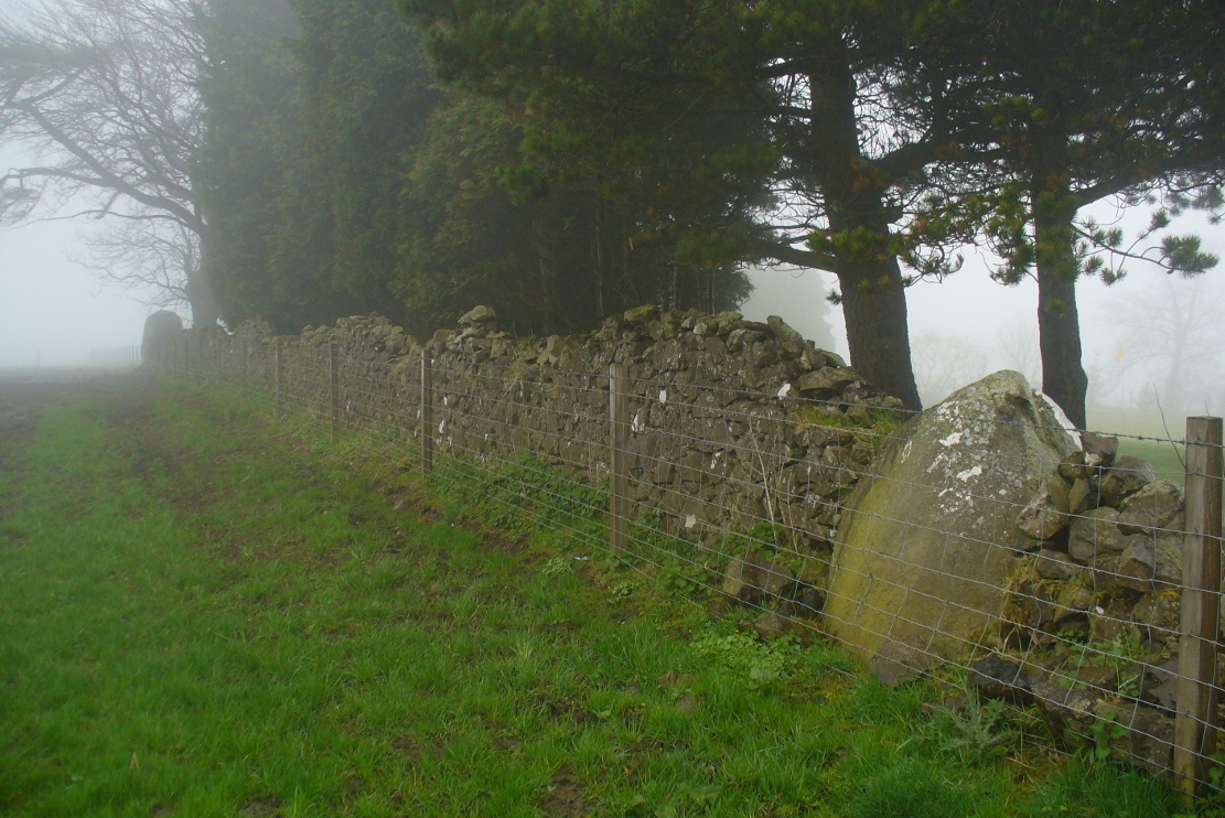
Near the very crown of this long hill, right by the gate separating the fields, you cannot miss this huge and very heavy-looking standing stone, whose position in the landscape was evidently of some importance to the people who put it here. It’s in a gorgeous spot. You can see in all directions for some considerable distance particularly to the west, and the eye catches other points on the land where prehistoric monuments of other forms speak to each other. (that’s assuming you visit here on a clear bright day, as opposed to when Paul Hornby and I visited the spot when, for much of the afternoon we could barely see 100 yards as the land all around us was cloaked in fog!)
The big fella, face onAnd through the fog, from the little fella to the big fella
The site was included in Alexander Thom’s (1990) magnum opus on megalithic stone rows, in which he cites it as a debatable 2-stone row monument. For if we walk westwards, along the walling, we find another large, possibly prehistoric upright about 50 yards along. In Aubrey Burl’s (1993) work on the same subject, he merely copies Thom’s earlier questioning of the second stone in his listings. But in Mr Beveridge’s (1888) regional history work more than a century earlier, he told clearly that on “the ridge of the hill behind Bandrum House, there are built two standing stones.” Of their origin and purpose, Beveridge could find none; but a few years later, A.S. Cunningham (1902) thought simply that
“of the two standing stones on the march fence behind Bandrum House…it is questionable if they ever served any other purpose than a dividing line for properties.”
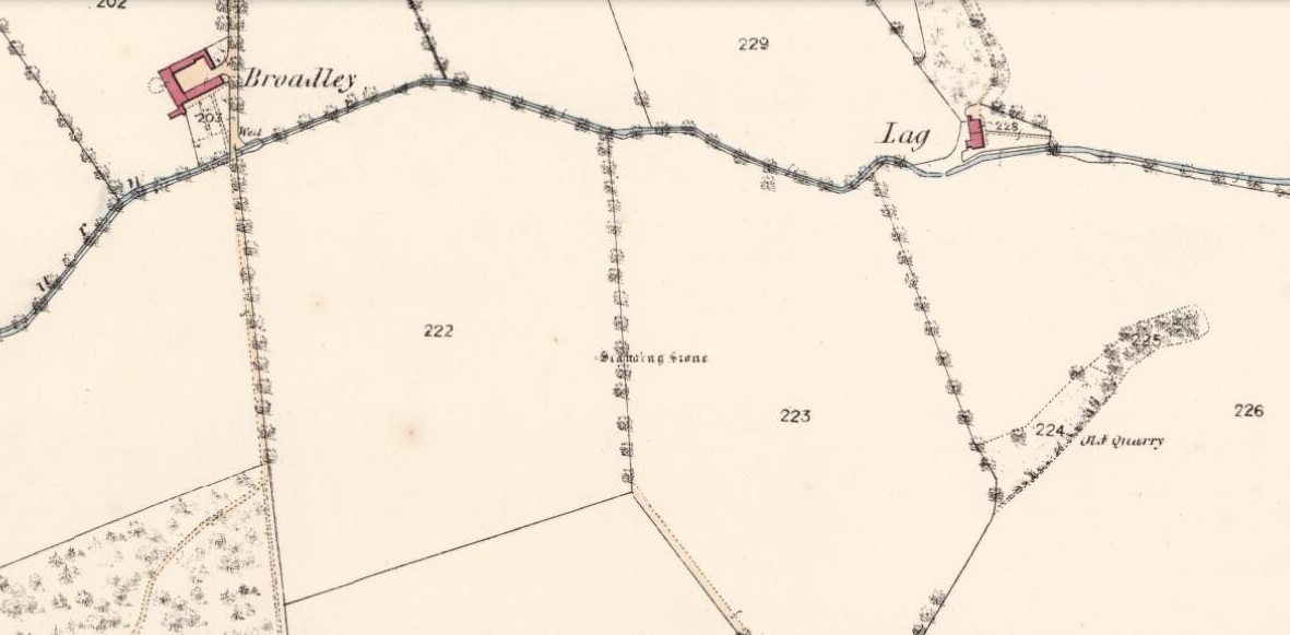
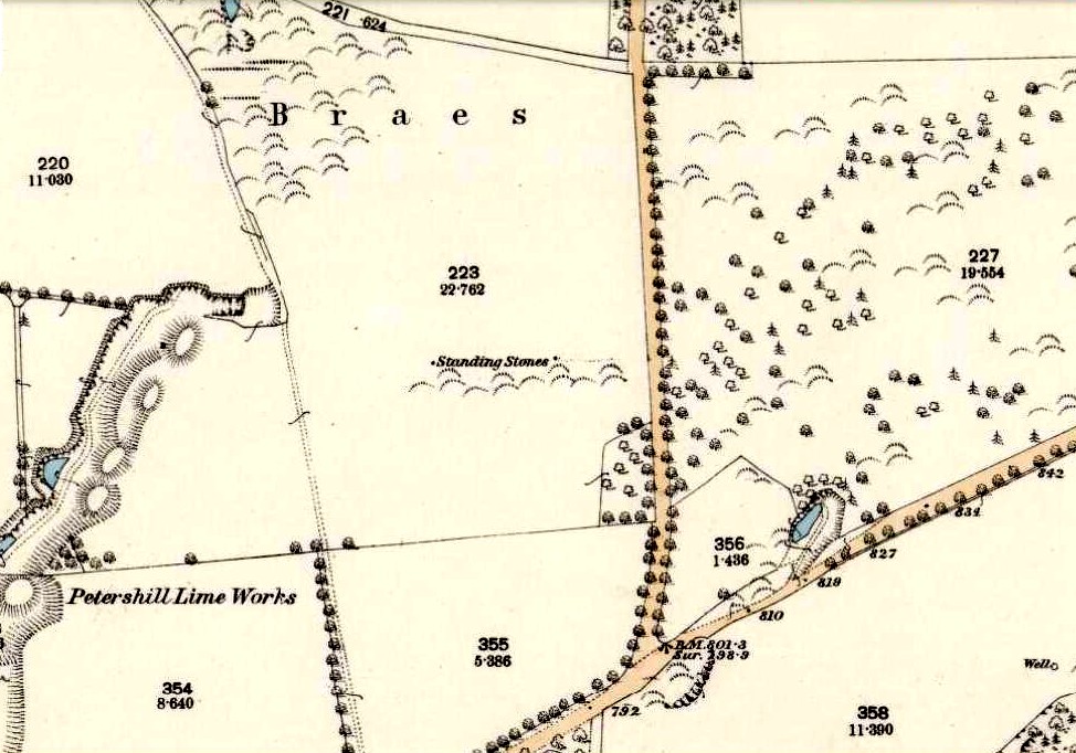
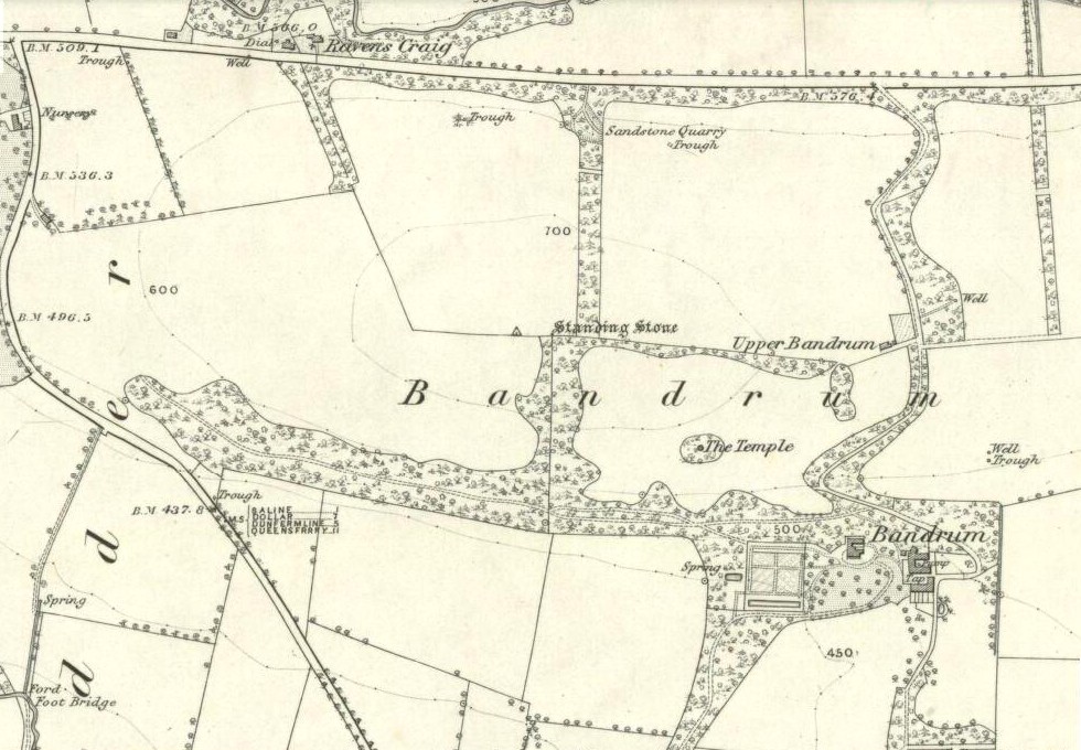
Bandrum Stone on 1854 map
The site was highlighted on the earliest OS-maps of the region in 1854—albeit with only the largest of the two stones marked, at the meeting of the gates—and then many decades later those other official doods, the Royal Commission (1933) lads, made their way up here and included the site in their inventory, where they told:
“On the crest of rising ground at an elevation of 700 feet above sea level, at the end of a dole near to the extreme east end of Saline golf course about a quarter of a mile due west of Bandrum farmhouse, stands a huge whinstone boulder of irregular form. It measures 7 feet 10 inches in height to the highest point of a somewhat rounded top, and has a slight inclination towards the west. Its girth at the base is 13 feet 7 inches and at the middle 14 feet 10 inches. The broadest faces are to the north and south… At a distance of 162 feet due west, there is another large boulder measuring 3 feet 10 inches in height and approximately 10 feet in circumference at the middle, set with a marked inclination towards the east and built into a continuation of the same dike. The two suggest the remains of a stone circle, the rest of which has been swept away by the cultivation of the neighbouring fields. There is however, no record of other stones having been removed.”
Thom’s (1990) account of the site was simply put: “Bandrum. NT 036 915. Huge whin boulder, 7ft 10 (2.4m) h. 162ft (49m) W another 3ft 10 (1.2m) h.” He gave no indication of astroarchaeological alignments.
References:
Beveridge, David, Between the Ochils and Forth, William Blackwood: Edinburgh 1888.
Burl, Aubrey, From Carnac to Callanish, Yale University Press 1993.
Cunningham, A.S., Romantic Culross, Torryburn, Carnock, Cairneyhill, Saline and Pitfirrane, W. Clarke: Dunfermline 1902.
Royal Commission on the Ancient & Historical Monuments, Scotland, Inventory of Monuments and Constructions in the Counties of Fife, Kinross and Clackmannan, HMSO: Edinburgh 1933.
Thom, A., Thom, A.S. & Burl, Aubrey, Stone Rows and Standing Stones – volume 2, BAR: Oxford 1990.
Acknowledgements: Huge thanks to Paul Hornby for his photos of these standing stones. Cheers Paul!