Cairney Mount, Carluke, Lanarkshire

Standing Stone (destroyed):  OS Grid Reference – NS 855 507

Archaeology & History

The Well & the field-name on the 1860 OS-map

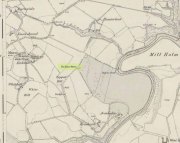
An ancient standing stone on the eastern side of Carluke isn’t something that most local people are aware of.  Sadly it’s long gone, but we find what seems to be a reference to it, both in the place-name Stanistone Road and the adjacent Standing Stone Well.  The monolith would seem to have stood immediately east of the well, as a description of it by Rev John Wylie (1845) in the New Statistical Account (1845) indicates.  Wylie told us that:

“Till lately, one of those remarkable monuments of antiquity, called standing stones, stood at Cairney Mount; but the hope of finding a hidden treasure induced some rude hand to destroy it.”

Cairney Mount is a field-name 300 metres east of the well, so it would seem highly likely there was an association between them, and the stone obviously stood somewhere between these two points.

References:

  1. Royal Commission on the Ancient & Historical Monuments of Scotland, Lanarkshire: An Inventory of the Prehistoric and Roman Monuments, HMSO: Edinburgh 1978.
  2. Wylie, John, “Parish of Carluke,” in New Statistical Account of Scotland – volume 6: Lanarkshire, William Blackwood: Edinburgh 1845.

© Paul BennettThe Northern Antiquarian

Langside Farm, Lanark, Lanarkshire

Cairn (destroyed):  OS Grid Reference – NS 866 411

Archaeology & History

This was an impressive site by the sound of things.  Sadly destroyed, its exact whereabouts isn’t clear but should—if the description of the site is anything to go by—be on one of the highest points of land around Langside Farm.  In Irving & Murray’s description (1864), they tell the cairn to have been one amidst a cluster of tombs that could once be seen “a mile to the south of his residence”, but this seems to be contested by the definitive pen of the Lesmahagow historian, John Greenshields. (1864)  He told us:

“The late Lord Corehouse had an excavation scientifically made of a karn or cairn on his farm at Longside.  It is to be regretted that information cannot now be obtained of so accurate a nature as the subject merits; but there were stones so arranged in the centre as to have been evidently intended for sepulchral purposes.  Two rude urns of baked clay, one very large, the other smaller, were found inside a stone coffin.  The small urn contained bones partially calcined and broken or pounded, some of them perfectly fresh.  It has been erroneously stated in Swan’s “Views of the Clyde,” that there were eighteen small urns around the large chest, in the form of a circle, which gave rise to the idea that the remains of the chief had been surrounded by those of his family or warriors. One of the urns has been lost sight of: the smaller one, about 6 inches in diameter at the top, and 4 in height, is now in the possession of Miss Edmondstoun Cranstoun, as well as a still smaller funerary urn, recently restored by kiln-burning it with some fresh clay.”

References:

  1. Greenshields, John B., Annals of the Parish of Lesmahagow, Caledonian: Edinburgh 1864.
  2. Irving, George V. & Murray, Alexander, The Upper Ward of Lanarkshire, Described and Delineated – volume 1, Thomas Murray: Glasgow 1864.
  3. Royal Commission on the Ancient and Historical Monuments of Scotland, Lanarkshire: An Inventory of the Prehistoric and Roman Monuments, HMSO: Edinburgh 1978.
  4. Swan, Joseph, Views on the Clyde – Historical and Descriptive, Joseph Swan: Glasgow 1830.

© Paul BennettThe Northern Antiquarian


Eastwood Farm, Lesmahagow, Lanarkshire

Cist (destroyed):  OS Grid Reference – NS 821 396

Archaeology & History

When the local historian John Greenshields (1864) wrote his definitive history of Lesmahagow parish, the book was just going to press when the remains of an ancient tomb was unearthed.  We are fortunate that he held publication of the book before adding the brief information about the findings.  He told us:

“When these pages were passing through the press, a stone cist was discovered on the farm of Eastwood, by the hollow sound emitted when the ploughshare struck its lid.  It was of the usual dimensions (about three feet by two), and contained fragments of bones, and a cinerary urn.  There were no indications that a cairn had ever been heaped on its top, but the stones may have long since been removed, as the field was in a high state of cultivation. The bones were much decayed, and the urn was shivered to fragments by the finder, in his anxiety to discover hidden treasures of gold or silver.”

No further information is known to exist about this site.  In all probability the cist was Bronze Age in nature, possibly earlier.  We surmise this from the rapid rate of decay of artefacts upon it being unearthed.

References:

  1. Greenshields, John B., Annals of the parish of Lesmahagow, Caledonian: Edinburgh 1864.
  2. Royal Commission on the Ancient and Historical Monuments of Scotland, Lanarkshire: An Inventory of the Prehistoric and Roman Monuments, HMSO: Edinburgh 1978.

© Paul BennettThe Northern Antiquarian


Trumpeter’s Well, Strathaven, Lanarkshire

Healing Well:  OS Grid Reference – NS 66014 41685

Also Known as:

  1. Canmore ID 203472

Getting Here

Trumpeters Well on 1864 map

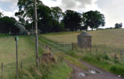
Take the A71 road southwest out of Strathaven as if you’re heading to Kilmarnock.  After 2½ miles (4.1km) you reach the tiny hamlet of Caldermill (be careful or you’ll truly miss it!).  As you go out of the hamlet, on your left there’s a track up to Hillhead Farm with the small but tell-tale signpost saying ‘Trumpeter’s Well’ and the small dome-shaped stone monument in the field is what yer looking for.  If you’re coming from the Kilmarnock side, when you reach the Caldermill sign, it’s in the field immediately to your right.  Y’ can’t really miss it.

Archaeology & History

When the site was surveyed by the Ordnance Survey lads in the 1850s, the water supply had completely run dry.  It was later revived and the nine-foot tall circular stone building built to commemorate its history.  The water apparently now runs within the building, being supplied from Hillhead Farm.

Trumpeters Well, Caldermill

Folklore

The well is said to have gained its name after the local Battle of Drumclog (1679), when one rich Tory known as John Graham of Claverhouse was retreating for fear of his life; and because his own horse had been killed, the coward stole the horse of his young fourteen-year-old trumpeter.  In doing so, the young lad was subsequently killed and his body was thrown down the well.  Tradition also tells that other soldiers were buried in the same field.

References:

  1. Campbell, J. Ramsey, My Ain, My Native Tour – Stra’ven, J.M. Bryson: Strathaven 1943.

© Paul BennettThe Northern Antiquarian

St. Bride’s Well, Avondale, Lanarkshire

Holy Well (destroyed):  OS Grid Reference – NS 6983 4138

Archaeology & History

St Brides Chapel & Well on the 1864 OS-map

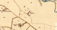
Shown on the 1864 OS map of the area as a ‘Well’ just at the front of St Bride’s Chapel—now a very pleasant old cottage—peasants and pilgrims would stop for both refreshment and ritual here as they walked down High Kype Road.  Although the chapel was described in church records of January 1542 as being on the lands of Little Kype, close to the settlement of St Bride, there seems to be very little known about the history or traditions of the well.  If anyone has further information on this site, please let us know.

Folklore

Bride or Brigit has her origins in early British myth and legend, primarily from Scotland and Ireland.  Her saint’s day is February 1, or the heathen Imbolc (also known as Candlemas).  Although in christian lore St. Bride was born around 450 AD in Ireland and her father a Prince of Ulster, legend tells that her step-father (more probably a teacher) was a druid and her ‘saintly’ abilities as they were later described are simply attributes from this shamanic pantheon. Legends—christian and otherwise—describe Her as the friend of animals; possessor of a magickal cloak; a magickian and a healer; and whose ‘spirit’ or genius loci became attached to ‘sacred sites’ in the natural world, not the christian renunciation of it.  St Bride was one of the primal faces of the great prima Mater known as the Cailleach: the greater Gaelic deity of Earth’s natural cycles, whose changing seasons would also alter Her names, faces and clothes, as Her body moved annually through the rhythms of the year.  Bride was (and is) ostensibly an ecological deity, with humans intrinsically a part of such a model, not a part from it, in contrast to the flawed judaeo-christian theology.

References:

  1. Paul, J.B. & Thomson, J.M., Registrum Magni Sigilli Regum Scotorum: The Register of the Great Seal of Scotland AD 1513 – 1546, HMGRH: Edinburgh 1883.

© Paul BennettThe Northern Antiquarian


Glesart Stanes, Glassford, Lanarkshire

Standing Stones:  OS Grid Reference – NS 73609 46916

Also Known as:

  1. Avonholm
  2. Canmore ID 45595
  3. Glesart Stones
  4. Struthers Burial Ground
  5. Three Stones

Getting Here

Glesart Stones on 1864 map

From the roundabout in Glassford village, head west down Jackson Street along the country lane of Hunterlees Road.  About 600 yards on, turn right at the small crossroads (passing the cemetery on yer left) for about half-a-mile, before turning left along a small track that head to some trees 400 yards along.  Once you’ve reached the trees, walk uphill and follow the footpath to the right, keeping to the tree-line.  It eventually runs to a small private graveyard. You’re there!

Archaeology & History
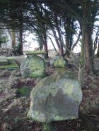
Glesart Stones,
looking west

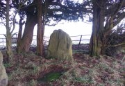
In the little-known private graveyard of the Struthers family on the crest of the ridge overlooking the River Avon and gazing across landscape stretching for miles into the distance, nearly a mile east of Glassford village, several hundred yards away from the Commonwealth graveyard, a cluster of yew trees hides, not only the 19th century tombstones, but remnants of some thing much more archaic.  Three small standing stones, between 2½ and 4 feet in height, hide unseen under cover of the yews, at the end of a much overgrown ancient trackway which terminates at the site.  They’re odd, inasmuch as they don’t seem to be in their original position.  Yet some form of archaic veracity seems confirmed by the weathered fluting: eroded lines stretching down the faces of two of the taller stones and, more importantly, what seem to be cup-markings on each of the monoliths.
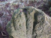
Cup-mark atop of east stone
Easternmost stone

The tallest stone at the eastern end of the graveyard has a deep cup on its crown.  This may be the result of weathering; but we must exercise caution with our scepticism here.  Certainly the eroded lines that run down this stone are due to weathering – and many centuries of it; but the peculiarity is that the weathering occurs only on one side.  This implies that only one side of the stone was open to the elements.
Central cup-marked stone
‘X’ carved atop of central stone

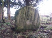
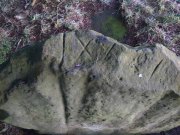
The second, central stone of the three, is slightly smaller than the first.  Unlike the eastern stone, its crown has been snapped off at some time in the past century or so, as evidenced in the flat smooth top.  But along the top are a series of small incised marks, one of which includes a notable ‘X’, which may have been surrounded by a circle.  A second fainter ‘X’ can be seen to its side, and small metal-cut lines are at each side of these figures.  Another small section of this stone on its southern edge has also been snapped off at some time in the past.  The most notable element on this monolith is the reasonably large cup-mark on its central west-face.  It is distinctly eroded, measuring 2-3 inches across and an inch or more deep.  Its nature and form is just like the one in the middle of the tallest of the standing stones at Tuilyies, nearly 31 miles to the northeast.
Western smallest stone
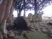
The Three Stones

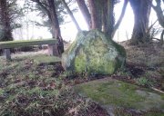
The smallest of the three stones is just a few feet away from the central stone.  To me, it seemed oddly-placed (not sure why) and had seen the attention of a fire at its base not too long ago.  On its vertical face near the top-centre of the stone, another cup-marking seems in evidence, some 2 inches across and half-an-inch deep—but this may be natural.  The Glasgow archaeologist Kenneth Brophy reported that on a recent visit, computer photogrammetry was undertaken here, so we’ll hopefully see what they found soon enough.

There is some degree of caution amongst some archaeologists regarding the prehistoric authenticity of the Glesart Stanes – and not without good cause.  Yet despite this, the seeming cup-marks and, particularly, the positioning of the stones in the landscape suggest something ancient this way stood.  The stones here are more likely to be the remains of a once-larger monument: perhaps a cairn; perhaps a ring of stones; or perhaps even an early christian site.  At the bottom of the hill for example, just 350 yards below, is a large curve in the River Avon on the other side of which we find the remains of an early church dedicated to that heathen figure of St. Ninian (his holy well close by); and 300 yards north is the wooded Priest’s Burn, whose history and folklore seem lost.

The Glesart Stanes were the subject of an extended article by M.T. M’Whirter in the Hamilton Advertiser in 1929 (for which I must thank Ewan Allinson for putting it on-line).  He wrote:

“Situated on the highest hill-top on the estate of Avonholm, north to the house of that name, is the private burial ground of James Young Struthers… Situated within the burial ground are three upright flagstones of a dark brown colour, rough and unhewn,  Each stone is facing the east, and placed one behind the other, though not in a straight line, and the space between the eastern and the middle stone is eight feet, and the space between the middle and the western stone is seven feet.  The stone flags vary in measurement, the eastern stone being the greater, standing four feet three inches high, three feet eight inches broad, and one foot thick.  The middle stone is three feet high, three feet ten inches broad, and nine inches thick; and the western stone is three feet high, four feet broad and ten inches thick.  The two outer stones bear no letters, figures or marks, but the centre stone has rudely sculptured on the top-edge the Roman numerals IX, and on the western side of the stone there is a cup-shaped indentation about two inches in diameter.  A groove 26 inches in length extends from the top of the stone to below the level of the cup indentation.  The groove is deeper at the top, but gradually loses in depth towards the bottom end.  I have seen grooves similar to above by the friction of a wire rope passing over a rocky surface.  The numerals, cup indentation and groove do not appear to be part of the original placing of the stones and, if a cromlech, then in the centuries that have gone, the stones becoming exposed to view by the removal of the mound, would invariably have led to a search for stone coffins or urns, yet no discovery of either has ever been recorded.”

Indeed, Mr M’Whirter was sceptical of them being part of a prehistoric burial site, preferring instead to think that a megalithic ring once stood here.  He continued:

“From an examination of the three stones, I am convinced that they form a segment of a circle, and assuming that nine additional stones complete the circle, it would enclose a space of roughly one hundred feet in circumference, with each stone facing an easterly direction.”

But we might never know for certain…. The only other literary source I have come across which describes the site is that by the local vicar, William Stewart (1988), who told us that:

“The stones stand erect, six feet apart, three rough slabs of coarse-grained sandstone, three feet high, three feet broad and six inches thick, free of any chisel marks.  Two have their back to the east, the third, oblique to the others, has its back to the south-east, thus there is no suggestion of a stone circle.  There are vertical grooves on two of the stones, while the centre stone has a cupmark, below which is a faint circle, one foot in diameter.  They stand at the end of a long narrow strip of land with low earthen walls on either side, perhaps an old agricultural field division, and they gave their name ‘Three Stanes’, to a now partly-lost road which eventually reached The Craggs and ended as Threestanes Road in Strathaven…”

The Three Stones

The “faint circle” described by Mr Stewart is barely visible now.  And the idea that these “three stones” gave their name to the farmhouse and road of the same name at the other side of Strathaven, three miles west, seems to be stretching credulity to the limits.  Surely?

Folklore

In 1845, Gavin Laing in the New Statistical Account for Lanarkshire told that:

“These stones are known simply as the “Three Stones”. There is a tradition in the neighbourhood that three Lords were buried here, after being killed while looking on at a Battle. The stones are about 3½ feet high and about as thick as flag stones. They stand upright being firmly fixed in the ground.”

The stones and their traditional origin were also mentioned in Francis Groome’s Ordnance Gazetteer (1884), where he echoed the 1845 NSA account, but also added:

“Three tall upright stones are here, and have been variously regarded as Caledonian remains, as monuments of ancient noblemen, and as monuments of martyrs.”

Then at the end of the 1850s, when the Ordnance Survey lads came here, they reported,

“Three high stones stand upright on a small eminence upon the lands of Avonholm, respecting their origin there are various opinions. They are probably the remnants of Druidical superstition.”

References:

  1. Groome, Francis H., Ordnance Gazetteer of Scotland – volume 1, Thomas C. Jack: Edinburgh 1884.
  2. M’Whirter, M.T., “The Standing Stones at Glassford,” in Hamilton Advertiser, 1929.
  3. Stewart, William T., Glasford – The Kirk and the Kingdom, Mainsprint: Hamilton 1988.
  4. Wilson, James Alexander, A Contribution to the History of Lanarkshire – volume 2, J. Wylie: Glasgow 1937.

© Paul BennettThe Northern Antiquarian


Three Stanes, Strathaven, Lanarkshire

Standing Stones (destroyed):  OS Grid Reference – NS 6957 4524

Archaeology & History

Threestanes on the 1864 OS-map

Threestanes on the 1864 OS-map

It seems that nothing remains of the three standing stones that gave rise to the place-name of Threestane Farm, at the top of Threestane Lane, on the northwestern outskirts of Strathaven.  We have no details on the size and form of the stones, nor when they were destroyed, but can presume that it was sometime prior to the Ordnance Survey lads coming here in 1858.

One local antiquarian, Maggie Overett, told that, “Slightly to the north east of Threestanes farm and near to the A726 Strathaven to East Kilbride road used to stand a farm called Westfield(still currently shown on my Google Earth) it was demolished over a year ago. Just behind what was the farm is a slight incline with what appears to be a standing stone. I have not been able to gain access to the site because of barriers put up by whoever owns the plot…… But it’s close enough to tie in the Threestanes estate…….and only a short distance from the known Strathaven Stane.”

Any further information about these lost monoliths would be greatly appreciated.

References:

  1. Bryson, J.M., Handbook to Strathaven and Vicinity, Townehead: Strathaven n.d.

© Paul BennettThe Northern Antiquarian


Stock Well, Glasgow, Lanarkshire

Healing Well (lost):  OS Grid Reference – NS 593 648

Also Known as:

  1. Ratten Well

Archaeology & History

This long lost well near the middle of Glasgow was known by this name as early as 1345.  Close to the River Clyde, a wooden structure was built around the well—a stock—and its waters were used by local fishermen.  A local fair used to be held hereby.  It has long since been built over and its original position no longer seems to be known.

Folklore

The old traditional tale behind this site was written in a short piece in the Scottish Journal of Topography oh so long ago now… One pseudonymous “R.M.S.” said that:

“Stockwell Street in the city of Glasgow, is pretty well-known, and everybody in the locality is aware of the ‘Ratten Well’ with its impure waters.  It is said that, in days of yore, when Sir William Wallace had occasion to be in that quarter, he and his party met a band of englishmen at the well.  A battle ensued, and the bodies of the englishmen, who were defeated, were thrown by the incensed Scots into the well.  “Stock it well! Stock it well” exclaimed Wallace, from which expression the street received its name.  So says tradition; and it is even yet believed that the bad quality of the water is owing to the putrefaction of the dead bodies of the englishmen.”

The one thing we can be certain about in this story, is that the Scots wouldn’t be stupid enough to dump dead bodies into their own fresh water supplies.  We must assume some englishman or dodgy corporation was responsible for that bit!

References:

  1. Bennett, Paul, Ancient and Holy Wells of Glasgow, TNA 2017.
  2. Brotchie, T.C.F., “Holy Wells in and Around Glasgow,” in Old Glasgow Club Transactions, volume 4, 1920.
  3. MacKenzie, Peter, Reminiscences of Glasgow and the West of Scotland – volume 1, John Tweed: Glasgow 1865.
  4. “R.M.S.”, “Stockwell Street, Glasgow,” in Scottish Journal of Topography, Antiquities & Traditions, volume 2, July 8, 1848.

© Paul BennettThe Northern Antiquarian


St. Anne’s Well, Strathaven, Lanarkshire

Holy Well:  OS Grid Reference – NS 7039 4438

Archaeology & History

St Anne's Well on 1865 map

St Anne’s Well on 1865 map

Long since lost it would seem, in a search for this legendary site over the weekend with Gordon, Aisha and Lara, I’m still not certain of the actual status of the site.  Although we found a very fresh water supply still running not far from where the old OS-map showed the original holy well to be, it may be a completely different water source.

There are hardly any references to the spring and those that exist are scant.  In the early 1860s, St. Ane’s Well was mentioned briefly in the Object Name Book of the area:

“This is a good spring well in the southern part of the town of Strathaven.  It is commonly called Tun’s (Tan’s?) Well, but this is an abbreviation of the name.”

Lara plays at a nearby well

Lara plays at a nearby well

Looking down on the waters

Looking down on the waters

More recently, thanks to a communication from the local historian Robert Currie, more information has come to light about the well.  It was described in the local history work by Mary Gebbie (1880).  Mr Currie told me:

“In her Sketches of Avondale and Strathaven…we read: “In a lane off Tod’s Hill was the famous Tann’s Well – obviously a corruption of the celebrated water saint, St. Anne. This spring has within a few years completely dried up. Access was easily had from the castle to it, over the draw-bridge, which is said to have rested on the ledge of the ground and rock on which the fifth house is built south of the bridge. Before this aperture was built up, the inhabitants around took advantage of the pathway for drawing water from the Pomillion, at a place called the Fairy Pool. A little above this comes the Dove Castle; and a half a mile further out is the Gallow Hill.”

He continued:

“That said, the current siting of St. Anne’s Well is located on Lesmahagow Road with (the) site being almost opposite the Council houses bordering on Station Road (there is currently a mini-roundabout near the locus). In recent years the site has become obscured but in my own living memory there was once a plaque authenticating the site and with a garden seat thereby.”

In searching through their own library, Mr Currie and his wife came across more about the site in William Downie’s (1979) book on Strathaven, in which he wrote:

“A small lane off Todshill went down to a cluster of houses called St. Anne’s Well nestling on the sloping ground beside the mill dam. In 1911 these houses were acquired and demolished by the Town Improvement Committee. A row of houses backing backing on to Powmillon Burn were also demolished at the same time and a retaining wall with railings erected, so opening up a very fine view of the castle and burn etc.”

The dedication here to the mythic figure of St. Anne (mother of the Virgin Mary and grandmother of Jesus) is isolated and mysterious.  No church is dedicated to her in the area, nor other relative christian remains.  Her appearance in Strathaven is something of an oddity.  There was a Duchess ‘Ann’ Hamilton of Strathaven Castle who lived 200 yards away at Strathaven Castle on the other side of the river that might have given her name to the well, but this is very unlikely.  More probable is that St. Anne was used as the mythic figure who covered an earlier dedication to the prima mater, or Cailleach—although there are no remains that relate to Her either.  However, the existence of St Mary’s church and an associated well to the north, along with a burn dedicated to a “maiden” in the same parish to the northwest add to the cailleach’s potential…..but all tales of Her have seemingly been forgotten.

…So it seems that the spring of water that Lara, Aisha, Gordon and I came across was obviously not the same place, but exists just below the roadside where the disused railway line is.  It’s close to St Anne’s Well – but is not the same water source.

References:

  1. Downie, Fleming, A History of Avondale and Strathaven, Eric Moore: Glasgow 1979.
  2. Gebbie, Mary, Sketches of the Town of Strathavon and Parish of Avondale: Historical & Traditional, John Menzies: Edinburgh 1880.

Links:

  1. Strathaven Past & Present

Acknowledgements:  Considerable thanks must be given to Robert Currie, BA Hons, who sent us additional information enabling a more informative and accurate site profile for this holy well.  Thanks Bob! Also huge thanks again to Aisha Domleo, Lara Domleo, Unabel Gordon and their frobbling Leonidus!

© Paul BennettThe Northern Antiquarian


Langside House, Cathcart, Glasgow, Lanarkshire

Cup-and-Ring Stone (removed):  OS Grid Reference – NS 5726 6128

Also Known as:

  1. Bluebell Woods
  2. Canmore ID 44291
  3. Langside Stone

Archaeology & History

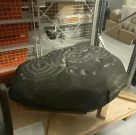
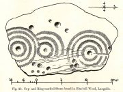
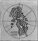
The Langside House, or Bluebell Woods carving

Amidst where now the busy city spreads on the south-side of Glasgow, there was once an excellent multi-ringed prehistoric petroglyph to be seen.  According to the official records, it was all alone – but I don’t buy that for one minute! (petroglyphs rarely occur in isolation)  However, it looks as if this might have been the last of its kind in the area, betwixt where now large houses grow in the landscape of Langside and Battlefield, a few hundred yards south of the hillfort-topped Queen’s Park.

Before being noticed by archaeologists, the stone was apparently being used as a stone seat in the woods for people to sit on!  It was probably a part of a larger monument, perhaps a cairn of some sort.  Certainly from the sketches we have of it, it was part of a larger piece of stone and was likely to have had companions, but records seem to be silent on the matter. The most detailed description of it comes from the pen of northern antiquarian Fred Coles (1906), who gave us the following literary portrait:

“The first notice of the Stone incised with the design shown below was due to Mr W. A. Donnelly, who contributed a description and a sketch to The Glasgow Evening Times of 25th June 1902.  Later, Mr Ludovic Mann, at my request, sent me certain notes he had taken of the cup-and-ring-marks.  But prior to this, the Stone itself had, on the instigation of Mr Donnelly, I think, been removed from its site in the wood, and placed near one of the entrances to the new Kelvinside Museum.  There I saw it and made measurements in July 1903.

“The Bluebell Wood lies in a curving line to the west and south of Langside House, and the cup-marked Stone was at a point in the southern extremity of the wood, above and north of the river Cart.  It is interesting to be able also to record that the longer axis of the Stone lay almost precisely north and South, and the opposite axis east and west.*  The Stone is of a hard, whitish sandstone, a good deal weathered and rounded at the edges. It measures 4 feet 9 inches in length and 3 feet 2 inches in breadth, and varies in thickness from 2 feet 6 inches to 1 foot 7 inches.  The striation of the Stone has helped to efface the cuttings which, though perfectly clear and measurable, are shallow in proportion to their width.  And this feature I have endeavoured to portray in the accompanying illustration (above).  Beginning at the north end of the Stone, there is one cup placed just where the outermost ring of that group touches the edge of the Stone.  The ring has a groove leading towards but not into a central cup, and four other cups are placed on the two outermost rings, there being four rings in this group.  The middle group consists of a central cup and three rings, flanked on the west by a row of three cups (one of which is the largest of all), and on the east by a double row of six cups, three of which are almost obliterated.  This middle group is imperfectly concentric, two of its arcs running into the fourth ring of the group on the south, which has a fine deeply picked central cup.  All the better-preserved rings are very nearly 1½ inches in width of cutting.

“The diameters of the outermost rings in each group are: of the north group, 1 foot 9 inches; of the middle group 1 foot 5 inches; and of the south group 1 foot 7 inches.  The cups vary in diameter from 3 inches to 1½.

“Considering the extremely easily weathered nature of this Stone, and the fact that its sculptured surface has already suffered much ill-usage, its present position, near the entrance of the Art Galleries, entirely unprotected by a railing and exposed to all sorts of abuse by casual passers-by as well as the weather, is not a fit and proper place for a Stone of such interest.”

A few years after this, the local historian Ludovic MacLellan Mann (1930) wrote a piece for the Glasgow Herald, in which he thought that both this and another carving in the area,

“commemorate chiefly…an eclipse of the sun seen in Glasgow district in the year 2983 BC, at three o’ clock in the afternoon of the sixth day after the Spring Equinox.”

A fascinating idea…  Mann was intrigued by the theory that petroglyphs represented astronomical events or maps of the skies – and we know from cultures elsewhere in the world that some carvings had such a function; but it’s not integral to all carvings by any means.

The stone was included in Ron Morris’ (1981) survey, merely echoing the description of Fred Coles, adding nothing more.  And so it seems that the carving is still in the museum somewhere.  Canmore has it listed as “Accession no: 02-78”.  Does anyone know of its present situation?  Can anyone get a photo so we can give it a more fitting site profile?  It looked a damn good carving!  And, if anyone lives nearby, I note that there are small patches of the old woodland still visible on GoogleEarth: therein, perhaps, a diligent explorer may just find another carving….

References:

  1. Coles, Fred, “Notices of Standing Stones, Cists and Hitherto Unrecorded Cup-and-Ring Marks in Various Localities,” in Proceedings of the Society of Antiquaries, Scotland, volume 40, Edinburgh 1906.
  2. Donnelly, W.A., “Letter”, Glasgow Evening Times, 25 June, 1902.
  3. Mann, Ludovic MacLellan, “The Eclipse in 2983 B.C. – Discovery near Glasgow,” in Glasgow Herald, 17.09.1930.
  4. Morris, Ronald W.B., “The Cup-and-Ring Marks and Similar Sculptures of South-West Scotland,” in Transactions of the Ancient Monuments Society, volume 14, 1967.
  5. Morris, Ronald W.B., The Prehistoric Rock Art of Southern Scotland, BAR: Oxford 1981.
  6. Morris, Ronald W.B. & Bailey, Douglas C., “The Cup-and-Ring Marks and Similar Sculptures of Southwestern Scotland: A Survey,” in Proceedings of the Society of Antiquaries, Scotland, volume 98, 1966.
  7. Small, Sam, Greater Glasgow: An Illustrated Architectural Guide, RIAS: Edinburgh 2008.

ACKNOWLEDGEMENTS:  Huge thanks to beautiful Aisha for putting me up.

* Although Coles did note how its earlier use as a stone seat probably negates his axial measurements.

© Paul BennettThe Northern Antiquarian