Woman’s Stone, Kirkmichael, Banffshire

Legendary Rock (lost):  OS Grid Reference –NJ 010 030

Also Known as:

  1. Cairn Gorm
  2. Canmore ID 15670

Archaeology & History

The exact location of this site seems privy to a select few and has remained that way since its existence appeared in print in the 19th century.  It was first mentioned by Arthur Mitchell (1874) following a holiday that he’d had in the area in the early 1870s.  He’d visited a petroglyph at Laggan with a Mr David Ross and when he returned home received a letter from him that told how,

“he had heard from Mr M’Bain of Auchterblair of two huge granite boulders, situated on a shelving rock over an abyss on the Loch Avon side of Cairngorm, with hand-made cups on them about a foot wide and correspondingly deep.”

They were subsequently visited by Thomas Wise (1884) a few years later, who told how these huge granite boulders were,

“20 feet in height,” upon which “there are four basins, 1 foot, or 1 foot and a-half long, and 6 inches wide at the top, rounding off to 1 inch in the bottom.”

Initially Mr Mitchell (1874) was cautious in associating these carved basins with cup-marked stones—and indeed, we concur with this—but seemed to have changed his opinion when he wrote about them a few years later (Mitchell 1881).  But it’s the folklore attached to this site that intrigued him – and myself…

Folklore

The traditions attached to this site will be recognised by all students of animism and folklore.  Arthur Mitchell (1874) was informed how the carved bowls in the stone helped infertile women and how “sitting on (them) is said to be efficacious in cases of barrenness.” Their importance was highlighted in the fact that there had been “pilgrimages to them undertaken within the memory of people still living.”

This was affirmed by Thomas Wise (1884) who told that,

“They are supposed to be efficacious in barrenness, and people still living remember pilgrims coming to sit upon them for some time, that they might obtain what they wished.  A visit to them was by no means an easy task, as the ascent was difficult, and to sit on them required a steady head, as they are on the brink of a rock overhanging a precipice.  These basins are the “woman’s stone” mentioned by Tennant.  They are supposed to be the resting place or throne of a certain fairy queen; but however efficacious they may have been, they have lost much of their celebrity; and as the shepherd, who acted as guide to the pilgrims, is dead, and has left no successor, they are now rarely visited.”

Does anyone know the whereabouts of this heathen magickal site?  If you happen to find it, see if you can get a good photo or two and let us know on our Facebook group.

References:

  1. Mitchell, Arthur, “Vacation Notes in Cromar, Burghead and Strathspey,” in Proceedings of the Society of Antiquaries Scotland, volume 10, 1874.
  2. Mitchell, Arthur, The Past in the Present, Harper: New York 1881.
  3. Wise, Thomas, A., History of Paganism in Caledonia, Trubner: London 1884.

© Paul BennettThe Northern Antiquarian

Conwath Stone, Inverkeithny, Banffshire

Standing Stone (destroyed):  OS Grid Reference – NJ 629 452

Also Known as:

  1. Canmore ID 18332
  2. Charter Stone
  3. Charterstone
  4. Conway Stone

Archaeology & History

The standing stone that could once be seen here is long gone.  Its existence was reported in John Stuart’s (1854) short essay on stone circles of the region, in which he told:

“On the summit of the Hill of Balnoon, or rather on its neck towards the east, there was till lately a lofty upright stone called The Conwath or Conway Stone, and by some The Charter Stone.  It was surrounded by a slight ditch.”

A recumbent stone in the field immediately north may relate to Stuart’s old report.

Folklore

In the same article, Mr Stuart told some interesting folklore which strongly implies the stone to have had importance for women. He said:

“It has been said that funerals coming from the west end of the parish were accompanied to this stone by the females of the family, and that the funeral here rested for a time, and the females returned (the stone being in sight of the churchyard). My informant (the minister of the parish) states, that a cairn on the hill of Auchinhamper was used for a similar purpose by funerals coming from the east end of the parish. On visiting the stone, however, I found that the churchyard was not visible from that spot.”

References:

  1. Stuart, John, “Notices of Various Stone Circles in the Parishes of Cairney, Monymusk and Tough, Aberdeenshire; and of Inverkeithny, Banffshire,” in Proceedings of the Society of Antiquaries Scotland, volume 1, 1854.

© Paul Bennett, The Northern Antiquarian


Tobar na Cailleach, Keith, Banffshire

Sacred Well:  OS Grid Reference – NJ 42659 47528 

Also Known as:

  1. Cailleach Well 
  2. Tobar Chailleach 
  3. Well of the Cailleach

Folklore

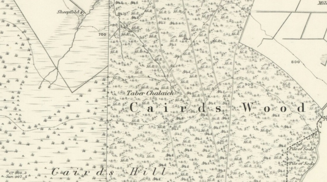
Cailleach Well on 1869 map

Described on the earliest OS-map of the region as Taber Chalaich, this great “well of the old woman, or hag” is found on the northern slopes of Cairds Hill, amidst increasingly dense woodland up the top of the stream which ebbs and flows in strength (depending on the weather).  A water source dedicated the prima mater Herself — i.e., the heathen pre-Celtic female creation deity par excellence — it was once of considerable repute locally as being a great curing well and was described by Ruth and Frank Morris (1981) as being,

“the scene of a pagan ceremony in which the Earth Mother in her old woman phase bathed at the well and returned as a young maiden.”

On the hill at the top we find remains of old tombs (mistakenly ascribed by Mr & Mrs Morris as ‘stone circles’), some of which may have had some mythic relationship with this legendary water source.  Further information and/or any photos of this little-known site would be hugely welcomed!

References:

  1. Morris, Ruth & Frank, Scottish Healing Wells, Alethea Press: Sandy 1982.

© Paul Bennett, The Northern Antiquarian


Haer Stanes, Llanbryde, Banffshire

Stone Circle (destroyed):  OS Grid Reference – NJ 2691 5985

Also Known as:

  1. Haerstanes
  2. Harestones

Archaeology & History

Haer Stanes on the 1871 map

This site had already passed into memory when the Ordnance Survey lads visited the area in 1870, but at least they included it on their early survey.  Fred Coles (1906) described this site in his essay on the megaliths of Banffshire, where once could be found perhaps five stone circles close to each other – but all are now gone!  Bloody disgraceful really.  When Coles explored here, although the site was still shown on maps, little could be seen of the place.

“On the farm,” he wrote, “we heard long-handed-down tradition of the Circle, and the site was, rather vaguely, pointed out.” But there was nothing there. He described one reference to the place written by a Mr James Morrison, who said, “We have remains of two so-called Druid Circles, and during the last half-century three others have been swept away. One of these was in horse-shoe form and was called the Haer Stanes.” The same writer later says, “These stones were unfortunately found to lie in the line of a road then formed (1830) and were ignominiously tumbled down the slope on which for ages they had rested, and buried in a gravel pit by the side of the road.”

References:

  1. Cole, Fred, ‘Report on Stone Circles Surveyed in the North-East of Scotland…’, in Proceedings of the Society of Antiquaries, Scotland, volume 40, Edinburgh 1906.

© Paul Bennett, The Northern Antiquarian