Mannerly Well, Gomersal, West Yorkshire

Healing Well:  OS Grid Reference – SE 2107 2515

Also Known as:

  1. Manor Lea Well

Archaeology & History

The site is one of the 2 wells on the 1847 OS-map

The site is one of the 2 wells on the 1847 OS-map

Originally called the ‘Manor Lea Well’ because it could be found on the far west of the land belonging to the Manor House, the name later became corrupted to ‘Mannerly’ by local folk. It was one of the four prime water supplies for this part of the old village, but it had other important social and festive rites attached that undoubtedly went back centuries.  H.A. Cadman (1930) told that:

“On Palm Sundays it was the custom for boys to take bottles containing Spanish juice, treacle, and any other sweet thing they could, for the purpose of having them filled with the water from the well. The boys then exchanged bottles with each other and each sampled the others. It was said that no better water existed for this purpose.”

This particular ritual was integral to virtually every Spa Well from Wakefield through to the source of the River Calder.

A Mr G.W. Parker said that the well was to be found at the “extreme Western side” of Manor Lea and was “still in existence” when Cadman wrote about it in 1930, “behind Company Mill” not far from the Moravian Burial Ground.  Do any local historians know if the well is still there, or has it since been destroyed?

References:

  1. Cadman, H. Ashwell, Gomersal, Past and Present, Hunters Armley: Leeds 1930.

© Paul BennettThe Northern Antiquarian


Lund Well, Bingley, West Yorkshire

Sacred Well (destroyed):  OS Grid Reference – SE 0973 4091

Archaeology & History

Lund Well on 1852 map

Lund Well on 1852 map

Once found in a cluster of three little wells all very close to each other near the top of the field where the Crossflatts roundabout joins up with the Aire-Valley trunk road, this is an intriguing site if you happen to be a pagan, or have an interest in druidism — and for one main reason: its name.  When I first came across a reference to the place about 25 years ago, the only piece of information I could find about it came from the arduous detailed researches of the Victorian industrial historian J. Horsfall Turner who, unfortunately, neglected to record much of the fading folklore in the region at his time.  Marked on the 1852 6-inch Ordnance Survey map, ‘Lund’ was a bit of an etymological curiosity, and Mr Turner (1897) thought the well’s name was little other than that of a local mill owner, whose nickname was ‘Lund’ Thompson.  He was guessing of course…and I thought little more about it…

Years later when looking through A.H. Smith’s (1961-63) magnum opus on the place-names of West Yorkshire, I found that he didn’t include the Lund Well in his survey.  However, an eventual perusal of Kenneth Cameron’s (1996) work told that in Old Norse place-names (and there is a preponderance of such places scattering Yorkshire and Lancashire), lund or lundr was a “‘small wood, grove,’ also had a meaning, ‘sacred grove’.” The word is echoed in old French, launde, meaning ‘forest glade’.  In A.H. Smith’s (1954) earlier etymological magnum opus he said that the word derives from a “small wood, grove, also a sacred grove, one offering sanctuary.”  However, Margaret Gelling (2000) urged caution on the origin of lund as a sacred grove and erred more to the usual English tendency of depersonalizing everything, taking any animistic attribution away from its root meaning; but we must urge caution upon her caution here!  Neither Joseph Wright (English Dialect Dictionary, vol.3 1905) nor William Grant (Scottish National Dictionary, vol.6, 1963) have entries for this word, so we must assume the Scandinavian root word origin to be correct.

One vitally important ingredient with the Lund Well is its geographical position.  For across the adjacent River Aire the land climbs uphill—and a few hundred yards above we reach the well-known and legendary Druid’s Altar, with its Druid’s Well just below.  This association is what suggests our Lund Well may have had a real association with a “sacred grove of trees”, as—despite us knowing very little about them—we do at least know that druids performed rites in sacred groves.  In Greenbank’s (1929) historical analysis of the Druid’s Altar, he was left perplexed as to the origin of its name as all early accounts and popular culture assigned it this title, and so he opted for the probability that the druids did indeed once perform rites here.  If this was true, then our seemingly innocuous Lund Well once had a much more sacred history than anyone might have thought.  Sadly, through their usual ignorance of such matters, the industrialists destroyed it….

References:

  1. Cameron, Kenneth, English Place-Names, Batsford: London 1996. 
  2. Gelling, Margaret, Place-Names in the Landscape, Phoenix: London 2000.
  3. Greenbank, Sydney, The Druid’s Altar, Bingley, R.G. Preston: Bingley 1929.
  4. Smith, A.H., English Place-Name Elements – volume 2, Cambridge University Press 1954.
  5. Smith, A.H., The Place-Names of the West Riding of Yorkshire – 8 volumes, Cambridge University Press 1961-63.
  6. Wainwright, F.T., Scandinavian England, Phillimore: Chichester 1975.

© Paul BennettThe Northern Antiquarian


Lady Well, Leeds, West Yorkshire

Holy Well (destroyed):  OS Grid Reference – SE 3060 3373

Archaeology & History

Lady Lane, where the well was

Lady Lane, where the well was

Deep in the industrial centre of Leeds, not far from the main bus station, could once be found one of Yorkshire’s many ‘Lady Wells’.  The great historian and antiquarian Ralph Thoresby (1715) was the first to write of this great spring, which is now lost beneath the concrete buildings near Quarry Hill.  He described it as,

“a noted spring…to this day called Lady Well and the adjoining way, Lady Lane.”

In 1806 Edward Baines of Leeds described this spring of “soft, pure water,” also telling it to be on Lady Lane, saying that

“At the bottom of this street is a spring of excellent water, called Lady-Well, which affords a copious supply of that necessary article to this populous part of town.”

This Lady Well was also included in Andrea Smith’s (1982) survey, who noted that less than two hundred yards northwest of was The Chantry of Our Lady. This church has medieval foundations and its dedication would be derived from the healing waters here; plus, Smith notes, in West Yorkshire, “the number of churches dedicated to Our Lady is only two and these are both classed as ancient.”

References:

  1. Baines, Edward, The Leeds Guide, E. Baines: Leeds 1806.
  2. Smith, Andrea N., “Holy Wells in and around Bradford, Leeds and Pontefract,” in Wakefield Historical Society Journal, volume 9, 1982.
  3. Thoresby, Ralph, Ducatus Leodiensis, London 1715.

© Paul BennettThe Northern Antiquarian


Doidy Poidy Well, Gomersal, West Yorkshire

Healing Well (lost):  OS Grid Reference – SE 209 260?

Archaeology & History

This bizarre-sounding well owed its name—if we are to accept H.A. Cadman’s (1930) version of history—to the local land-owner,

“Joseph Mortimer and it was so-called because Mortimer’s christian name was Doidy Poidy.”

But this seems unlikely.  The term ‘doidy’ is a local dialect word, seemingly found only in West Yorkshire, meaning ‘an overdressed person, especially female,’ (Haigh 1928), with doidy-poidy being rhyming slang for the same thing.  The english dialect magus, Joseph Wright (1900), proclaimed the same derivative, “a badly dressed woman, a dowdy.”  So it may have been that this title was endowed upon Mortimer’s wife.

Cadman told that the Doidy Poidy Well was one of the “chief wells” of Gomersal, implying that its waters were good and strong.  Its existence on what was known as “the old feasting grounds” may have played a part in the “public rejoicings which last for days… The feast was on the Monday on or before Lady Day.” (March 25th, around spring equinox)  However, Cadman assures us that the celebrations were started “when the Gomersal Cloth Hall was opened,” telling us that “this feast or fair is not therefore an ecclesiastical one.”

The exact whereabouts of the Doidy Poidy Well remains a mystery (the map-link, above, shows an approximation from the middle of Gomersal).

References:

  1. Cadman, H. Ashwell, Gomersal, Past and Present, Hunters Armley: Leeds 1930.
  2. Haigh, W.E., A New Glossary on the Dialect of the Huddersfield District, Oxford University Press 1928.
  3. Wright, Joseph (ed.), English Dialect Dictionary – volume 2, Henry Frowde: London 1900.

© Paul BennettThe Northern Antiquarian


St. Helen’s Well, Thorpe Hesley, South Yorkshire

Holy Well (lost): OS Grid Reference – SD 370 960

Archaeology & History

In Rob Wilson’s (1991) study on the saints and wells of South Yorkshire, he mentions this site which, it would seem, may have been lost to history.  In Wilson’s site-entry for the St. Helen’s Well at nearby Barnburgh, he tells that,

“There may have been other wells in South Yorkshire dedicated to St. Helen… Two 18th century surveys by William Fairbank list St. Helen’s Fieldin Thorpe Hesley and St. Ellen’s Field in Wentworth.”

Around ten different wells are highlighted in the village itself on the first Ordnance Survey map of the area, with a number of others scattered in the surrounding fields.  Any one of these may be the well in question.  Much of the region was badly disfigured by the Industrialists in their usual desecration of the landscape, which may make any recovery of this site impossible.  However, a foray into the whereabouts of William Fairbank’s survey could be worthwhile — and if St. Helen’s Field is one that remained untouched by local mining, the site could be recovered from its present “lost” status.

(Please note: the grid-reference cited above is an approximation until further data allows us to correct it.)

References:

  1. Wilson, Rob, Holy Wells and Spas of South Yorkshire, Northern Arts: Sheffield 1991.

© Paul BennettThe Northern Antiquarian


St Francis’ Well, Conisborough, South Yorkshire

Holy Well:  OS-Grid Reference – SK 5112 9880

Also known as:

  1. Town Well

Getting Here

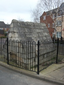
From Church street turn down into Wellgate, the well is on the right hand site at 18 Wellgate surrounded by railings near some new properties, on a little island.

Archaeology & History

Near the castle, and although dry it is a substantial site variously called the Town well or the Well of St Francis.  This is as C.F. Innocent (1914) described it:

“Covered by a curious little building very medieval-looking  with it a chamfered plinth and steeply slanted roof”

Little is recorded of its history, but the structure more a conduit house probably dates from the 1500s at the earliest and was used as source of domestic water until the 1900s.

Folklore

Which St Francis it is, is unclear, but Alport (1898) records the local tradition which states that he was a local holy man and probably not a true saint and it is interesting that a number of churches are dedicated to a St. Francis in Yorkshire. Interestingly though, the date of creation of the well is recorded and is quite late compared to other local saints.

It is said that in 1320 -1321 the village was suffering from a particularly terrible drought and this St. Francis, said to be an old and wise man was sought for his advice. He suggested that the local people cut a willow tree from Willow Vale and then as the people sang psalms and hymns he lead them through the church and priory grounds to the site of the well. At the spot St Francis then struck is and not only did a spring arise and followed for the next 582 years (for its sadly dry now) but the tree took root.

Sadly this tree has either died or was dug up. Clark (1986) believes the story recalls a Pagan priest and that the legend was a legacy of Conisbrough’s pre-Christian past; certainly the reference to a willow indicates a water diviner.

Extracted and amended (where both sites of the town are discussed) from http://insearchofholywellsandhealingsprings.wordpress.com/2011/12/11/a-yorkshire-field-trip-conisboroughs-two-holy-wells/

References:

    1. Allport, C.H., (1898) History of Conisborough.
    2. Clark, S., (1986) “The Holy well of Conisborough,” in Source, Old Series no.5.
    3. Innocent, C.F (1914-18) “Conisborough and its Castle,” in Trans of Hunter Archaeology Society.

© Ross Parish


St Peter’s Well, York Minster, North Yorkshire

Holy Well:  OS Grid Reference – SE 6038 5219

Also Known as:

  1. Holy Well, York Minster

Archaeology & History
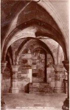
Old photo of the well

Old photo of the well

For people who like to visit the sacred sites that determined a cross-over from Earth-based animism to one which ceased sanctifying the Earth, this ancient water source in the cellars beneath York Minster would be a good example.  Sadly, the church has closed off access to this ancient heritage and you can no longer see it.  Yet despite the fact that the modern-day christians have closed off your encounter with this important heritage site (York Minster’s website doesn’t even mention its existence!), we should not forget its mythic history…

As you walk into the building (at some great expense, it has to be said), the location of the holy well is said to be at its more western end, albeit in the crypt underground—although there does seems to be some confusion with some authors about exactly where the well is positioned.

1850 sketch of the well

1850 sketch of the well

The earliest account we hear of the place relates to when the northern tribal King Edwin, along with his sons Osfrid and Esfrid, came here to be “baptized” in the waters of this clear spring “on Easter day, April 12, 627” CE.  Immediately thereafter a small wooden chapel was constructed next to or above the well.  From then on, as the centuries passed, the renown of the well grew and eventually the magnificent ritual temple of York Minster was eventually built.  The waters eventually became dedicated to St. Peter and an annual festival occurred here soon after the Midsummer solstice on what became known as St. Peter’s Day (June 29).  After the year 1462, a secondary festival date was also given to the site by the Church and another annual celebration occurred here on October 1 too.  Its waters remained accessible to people for drinking, healing and rites throughout the centuries.  It is only now, in the 21st century, that its sacrality and spirit has been closed-off.  This is a situation that must be remedied!

In Mr Goole’s (1850) survey of York Minster, his architectural illustration of the building showed that the water from the well had been brought up onto the ground floor, on the southeast side of the inner cathedral building in the easternmost vestry, and named as St Peter’s Pump.  This is illustrated in the 1850 drawing above-left.

A whole series of early writers mention the well in earlier centuries—of whom a brief sample is given here.  When Celia Feinnes came here in the 17th century, she said that,

“In the vestry of York Minster there is a well of sweet spring water called St Peter’s Well ye saint of ye Church, so it is called St Peter’s Cathedral.”(Smith 1923)

Mr Torre (1719) gave it equal brevity, saying simply that,

“at the south-west corner thereof is a draw-well (called St. Peter’s Well) of very wholesome clear water much drunk by the common people.”

In R.C. Hope’s (1893) national survey of sacred wells, he told that

“There is a draw well with a stone cistern in the eastern part of the crypt of York Minster… The Crypt is about 40 feet by 35 feet.”

The well was even included in Murray’s Handbook to Yorkshire (1892) as being “in the southwest corner of the Minster.” William Smith (1923) included the site in his fine survey, telling his readers that,

“The water is excellent in quality, which in measure, so chemists say, is due to the lime washed into it by the rain from the walls of the Minster.  The water has for centuries been used for baptisms, and is so used today.  The well has now for some years been covered with a pump.”

Folklore

In Geoffrey of Monmouth’s famous early History, we find that King Arthur visited here. …And one final note, about which we know not for certain whether it was relevant to the holy well hiding in the crypt, but a fascinating heathen custom was enacted here in bygone days, almost above the spring.  Mistletoe, as Christina Hole (1950) told,

“was ceremonially carried to the cathedral on Christmas Eve and laid upon the high altar, after which a universal pardon and liberty for all was proclaimed at the four gates of the city for as long as the branch lay upon the altar.”

Mistletoe is one element that is known to have been sacred to the druids (not the present-day druids!) and was sacred to the ancient Scandinavians (who came here), and also possessed the powers of life and death in its prodigious folklore and phytochemistry.  Fascinating…

…to be continued…

References:

  1. Bord, Janet, Cures and Curses: Ritual and Cult at Holy Wells, HOAP: Wymeswold 2006.
  2. Gutch, Mrs, County Folk-lore volume 2 – North Riding of Yorkshire, York and the Ainsty, David Nutt: London 1901.
  3. Hole, Christina, English Custom and Usage, Batsford: London 1950.
  4. Hole, Christina, English Shrines and Sanctuaries, Batsford: London 1954.
  5. Hope, Robert Charles, Legendary Lore of the Holy Wells of England, Elliott Stock: London 1893.
  6. Murray, John, Handbook for Travellers in Yorkshire, J.Murray: London 1874.
  7. Parkinson, Thomas, Yorkshire Legends and Traditions, Elliot Stock: London 1888.
  8. Poole, G.A., An Historical and Descriptive Guide to York Cathedral and its Antiquities, R. Sunter: York 1850.
  9. Purey-Cust, A.P., York Minster, Isbister: London 1898.
  10. Rattue, James, The Living Stream: Holy Wells in Historical Context, Boydell: Woodbridge 1995.
  11. Smith, William, Ancient Springs and Streams of the East Riding of Yorkshire, A. Brown: Hull 1923.
  12. Torre, James, The Antiquities of York, York 1719.
  13. Whelan, Edna, “Holy Wells in Yorkshire – part 1,” in Source, No.3, November 1985.
  14. Whelan, Edna, The Magic and Mystery of Holy Wells, Capall Bann: Chieveley 2001.
  15. Whelan, Edna & Taylor, Ian, Yorkshire Holy Wells and Sacred Springs, Northern Lights: Dunnington 1989.

© Paul BennettThe Northern Antiquarian


Egg Well, Ashenhurst, Leek, Staffordshire

Healing Well:  OS Grid Reference — SK 005 540

Egg Well, Ashenhurst

Egg Well, Ashenhurst

Getting Here

Just outside of Leek a right-hand lane leads to the small hamlet of Ashenhurst, turning left pass the gated road and on the right hand side at the next fork is the The egg well on the right in a small brick building.

Archaeology & History

The Egg Well is a curious site.  No evidence appears to record it as a holy well, nor a spa— but it appears to be a secular healing well.  Local tradition believes that the site was used by the Roman, but the older fabric was set in place by William Stanley, the owner of Ashenhurst Hall bewteen 1744 and 1752.  The present house was erected in the 19th century.

Waters of the well

Waters of the well

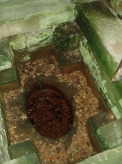
The name of the well is curious; it could refer to the shape of the basin, but could also refer to sulphurous waters although I could not detect a smell.  Today, a rather ugly 19th century brick-built structure surrounds this stone lined bath-shaped structure, which was roofed at a later date.

Folklore

The site was used by the Romans, but there is no evidence.  Its properties are recorded on the basin is this monogram and an interesting Latin inscription which reads:

“Renibus, et splenui cordi, jecorique medatur, Mille maelsi prodest ista salubris aqua.”

The translation being:

“The liver, kidneys, heart’s disease these waters remedy. And by their healing powers assuage full many a malady.”

References:

  1. Parish, R.B., Holy Wells and Healing Springs of Staffordshire – in publication.

Links:

  1. Holy Wells & Healing Springs – Staffordshire

© R.B. Parish, The Northern Antiquarian


St. Mary’s Well, Wallingwells, Nottinghamshire

Holy Well:  OS Grid Reference – SK 572 840

Archaeology & History

Old photo of St Mary's Well

Old photo of St Mary’s Well

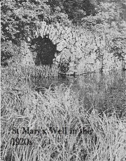
First mentioned in Pipe Rolls and referred to by the founder of Wallingwells Benedictine Priory (founded around 1150 CE) as ‘juxta fonts et rivum fontium’, the site Wallingwell or originally Waldon-by-the-Wells, may be significant.  The name refers to ‘bubbling wells’, but whether these wells were dedicated appears to be unknown, although it does seem likely.  Indeed, an anonymous article from the Worksop Guardian dated 1929 on the Wallingwell Estate, shows the well arising under a rough stone work arch beside the site of a lake.  Close by, appears to be a grotto of a similar construction. The article states that the grotto was built 250 years (from 1929 this suggests a date of 1679 which appears a little too early for this folly, a date in the 18th century being more likely). This was done by Thomas White using stone from petrified springs in Derbyshire. No reference is made of the well, but one assumes that it was built at the same time, but whether White was constructing a folly around an existing traditional site again is unknown.

Baker (2000) refers to the castle folly but fails to reference these sites suggesting that it had vanished. However, grotto and well still exist in the overgrown and forlorn garden to the back of the house.  The grotto is well-preserved, although signs of ruination are evident and the urn within has gone.

The internal brickwork

The internal brickwork

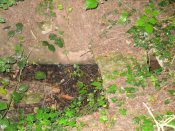
The overgrown well

The overgrown well

St. Mary’s Well is the most ruined. The archway appears to have fallen or been knocked down but the channel or basin the spring flows into still exists. Observation underneath a flattened stone covering the channel show that the spring flows from a pipe further up and under a series of neat brick arches. It is clear that the well structure was never accessible as it abutts onto the Lake, but was designed to be seen from the other side of the Lake. This view now is difficult due to the considerable plant growth obscuring the sites. It is good to see that the well still exists and hopefully the garden could be restored.

Extracted from R. B. Parish (2009) Holy Wells and Healing Springs of Nottinghamshire

Links:

  1. Holy & Healing Wells

© R.B. Parish, The Northern Antiquarian


Hawklemass Well, Whittingham, Northumberland

Healing Well:  OS Grid Reference – NU 0683 1228

Archaeology & History

Hawklemass Well on 1866 map

Hawklemass Well on 1866 map

References to this site seem very scarce.  A well is highlighted on the 1866 OS-map of the region close to the spot which D.D. Dixon (1895) said it was found, “near to the Howbalk Lane end, where is also the Hawklemass Stile and Hawklemass Well.”  A stone trough could once be seen here, but its presence today needs to be confirmed by local researchers.  The site is listed in Binnall & Dodds (1943) survey, but with no additional comments to those made by Mr Dixon.

Folklore

The historian D.D. Dixon (1895) told that the village of Whittingham only had one ghost, but it was known as the “Hawklemass Ghost” and was occasionally encountered at the Hawklemass Well:

“This was a place never passed after nightfall by the youth of the village without feeling an eerie, creepy sensation, and with many a furtive glance on either side.  This unearthly visitant, in its gambols and uncanny pranks, was said to rattle the chain by which it was supposed to be bound in a fearsome manner.  It was usually seen or heard by persons who, having lingered long at the village inn, could say with Tam o’ Shanter,

“While we sit bousing at the nappy,
An gettin’ fou and unco happy,
We think na on the lang Scots miles,
The mosses, waters, slaps and styles,
That lie between us and our hame.”

One Saturday night many years ago—perhaps fifty—a poor fellow on his way from Whittingham to Glanton fel into the roadside at Hawklemass, where he was found, quite dead, the next morning by some persons on their way to Glanton meeting.  This sad affair may have given rise to the tradition of the Hawklemass Ghost.”

The name of the old lane at whose junction the Hawklemass Well once flowed, ‘Howbalk Lane’, may derive from a lost tumulus, as the word how (and its variants) regularly relate to prehistoric mounds in our more northern climes.  Such an ancient tomb, close to the well, may be the origin of the ghost story.

References:

  1. Binnall, P.B.G. & Dodds, M.H., “Holy Wells in Northumberland and Durham – part 2”, in Proceedings of the Society of Antiquaries Newcastle-upon-Tyne, 10:2, 1943.
  2. Dixon, David Dippie, Whittingham Vale, Northumberland, Robert Redpath: Newcastle 1895.

Acknowledgements:  With thanks to Gill Rutherford for prompting me to finish this; and to Claire Heron for the OS-map reference.

© Paul BennettThe Northern Antiquarian