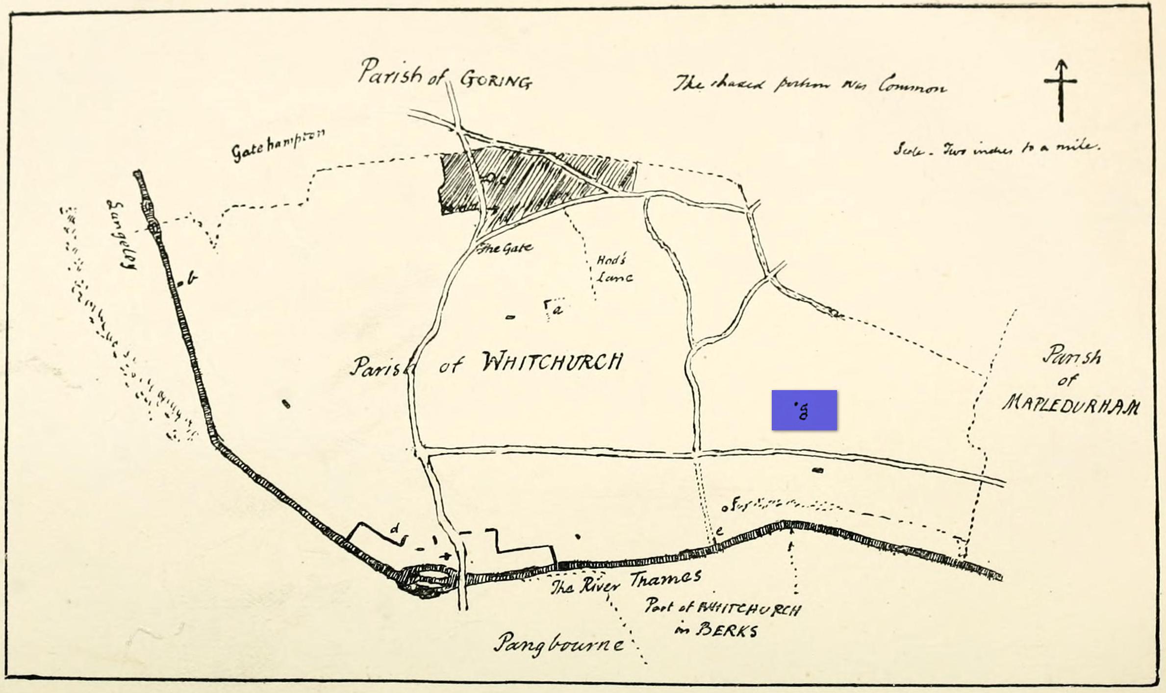
Maypole (destroyed): OS Grid Reference – SU 655 781
Archaeology & History
“g” marks the spot!
Very little is known about the history surrounding Whitchurch’s maypole that once stood more than a mile east of the village, somewhere in the woods immediately south of the present-day cannabis-growing Hempem Organics. (damn those hippies!) Mentioned in the Enclosure Acts of 1806 and 1813 as the “May Pole Ground”, the monument was mentioned in the Rev. John Slatter’s (1895) local history work and its approximate location was shown on a hand-drawn map he did of the area, in the grounds north of Hardwick House. He told us that it stood on “an elevated site” and conjectured that it might once have been a place of druidical worship!
“In the centre of the Hardwick property is a plot of ground called the Maypole Piece…. It is an open space, with a tree standing alone, where we may suppose the maypole formerly stood. There is a memorandum made by the last Mrs. Lybbe (nee Isabella Twysden) to this effect:
1713: A maypole set up on ye hill in ye straight way to Collinsend.”
In the event that you manage to discover anything else about the history of this maypole, let us know on our Facebook group.
References:
Gelling, Margaret, The Place-Names of Oxfordshire – volume 1, Cambridge University Press 1953.
Slattter, John, Notes on the History of the Parish of Whitchurch, Elliot Stock: London 1895.
Holy Well (destroyed): OS Grid Reference – TL 997 254
Archaeology & History
Near the centre of the ancient city could once be found the flowing waters of St. Helen’s Well. It was described many times in various legal and land documents from as early as 1331 CE onwards, in Colchester’s Oath Book. However, descriptions of the site itself and its curative abilities were not noted. It was simply associated with St Helen’s Chapel, whose original foundations date from the 12th century.
Folklore
One tradition told that it was St Helen herself who founded the chapel here. St Helen’s feast day is Agust 18.
References:
Benham, W. Gurney (trans.), The Oath Book; or, Red Parchment Book of Colchester, Essex County Standard: Colchester 1907.
Holy Well (destroyed): OS Grid Reference – TQ 102 952
Archaeology & History
A long lost sacred site (not to be confused with the nearby Bright Well) that has given its name to the district of Holywell. It also gave its name to an early farmstead; and to the place-name of Holywellane recorded as far back 1485. It was also described as a “Holy Well” in a local vestry book in 1698. Nothing more seems to be known of the place.
References:
Gover, J.E.B., Mawer, Allen & Stenton, F.M., The Place-Names of Hertfordshire, Cambridge University Press 1938.
Harte, Jeremy, English Holy Wells – volume 2, Heart of Albion press: Wymeswold 2008.
Holy Well (destroyed): OS Grid Reference – TL 2214 0449
Archaeology & History
An early reference by Nathaneal Salmon (1728) told that in the grounds of St. Mary’s church by the vicarage there was a well, which may or may not have been deemed as ‘holy’. He wrote:
“There is a Dale in Coppice belonging to the Manor of Potterels, from which, after a great Quantity of Rain, the Water comes through Veins of Chalk to the Vicarage Well, and is white.”
No well is shown on the early OS-maps at this place and we can only assume that it was either capped or had fallen back to Earth not too long after Salmon’s visit.
References:
Salmon, N., The History of Hertfordshire; Describing the County and its Monuments, London 1728.
Acknowledgements:Huge thanks for use of the Ordnance Survey map in this site profile, reproduced with the kind permission of the National Library of Scotland.
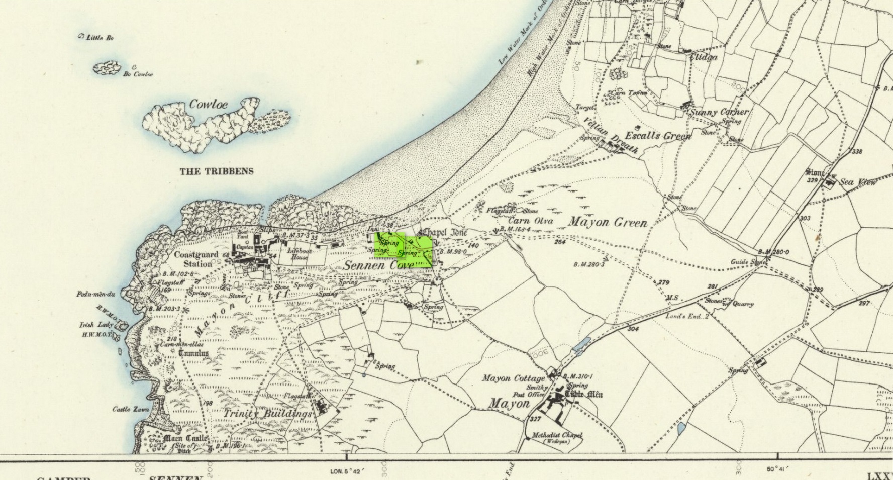
Holy Well (lost): OS Grid reference – SW 3550 2626
Archaeology & History
The springs of Chapel Idne
Highlighted on the 1888 Ordnance Survey map of Sennen Cove are the remains of Chapel Idne, just above the coast. Across the road from the chapel on its south-side, and also next to an old inn to its immediate west, springs of water are shown and it would seem more than likely that one of these two would have been the forgotten holy well of Sennen that was described, albeit briefly, in the great Mr Blight’s (1861) literary tour of the area. He told us that:
“At Sennen Cove was an ancient chapel, called by the people Chapel Idne, the “narrow chapel” being forty-five feet long and fifteen feet wide. It is now converted into a dwelling. Tradition says it was founded by one Lord of Goonhilly, who possessed dome portion of the land of Lyonesse. There was a holy well of some repute here also.”
The waters of St. Sennen’s Well were used in an act of ceremonial magick in the Arthurian tale known as the Battle of Vellan-druchar, as told in Robert Hunt’s (1865) great Romances. An attempted invasion by the Danes was met with by Arthur and nine other kings and the foreigners were slaughtered.
“A few had been left in charge of the ships, and as soon as they learned the fate of their brethren, they hastened to escape, hoping to return to their own northern land. A holy woman, whose name has not been preserved to us, “brought home a west wind” by emptying the Holy Well against the hill, and sweeping the church from the door to the altar. Thus they were prevented from escaping, and were all thrown by the force of a storm and the currents either on the rocky shore, or on the sands, where they were left high and dry. It happened on the occasion of an extraordinary spring-tide, which was yet increased by the wind, so that the ships lay high up on the rocks, or on the sands; and for years the birds built their nests in the masts and rigging.
Thus perished the last army of Danes who dared to land upon our western shores.
King Arthur and the nine kings pledged each other in the holy water from St Sennen’s Well, they returned thanks for their victory in St Sennen’s Chapel, and dined that day on the Table-men.
Merlin, the prophet, was amongst the host, and the feast being ended, he was seized with the prophetic afflatus, and in the hearing of all the host proclaimed–
“The northmen wild once more shall land,
And leave their bones on Escol’s sand.
The soil of Vellan-Druchar’s plain
Again shall take a sanguine stain;
And o’er the mill-wheel roll a flood
Of Danish mix’d with Cornish blood.
When thus the vanquish’d find no tomb,
Expect the dreadful day of doom.”
References:
Blight, J.T., A Week at the Land’s End, Longmans Green: London 1861.
Hunt, Robert, Popular Romances of the West of England, 1865.
Straffon, Cheryl, “Chapel Idne and the Holy Well,” in Meym Mamvro no.34, 1997.
Weatherhill, Craig, “A Guide to Holy Wells and Celebrated Springs in West Penwith,” in Meym Mamvro no.4, 1997.
Acknowledgements: Big thanks for use of the early edition OS-map in this site profile, Reproduced with the kind permission of the National Library of Scotland.
Healing Well (destroyed): OS Grid Reference – TQ 318 703
Archaeology & History
This was one of several so-called mineral springs in and around the Norwood area, but seemingly the least well-known—certainly in literary terms. Whatever renown it may once have had was overwhelmed by the relative proximity of the much more famous curative waters of the Beulah Spa, a few hundred yards to the southeast. It was mentioned, albeit briefly and already in the past tense, in John Anderson’s (1898) survey, when he told that “There used to be (a) mineral well at Biggin Hill. It is marked on the Croydon Inclosure Map” of 1800 and shown as a “Spring”, north of Biggens Farm. It seems that it had only just been destroyed when Anderson wrote about it, as the research of Alfie Foord (1910) showed. His inquiries found that,
“There used to be another mineral well about half a mile to the north-west of Beulah Spa, at Biggin Hill, the water from which gushed up at the rate of seven gallons a minute. In 1898 it was closed. The subjoined analysis of water from a well, which is at White Lodge, Biggin Hill, formerly the residence of Mr. H. Wilson Holman, was kindly supplied by him to the writer in 1907. This well, he says, undoubtedly taps the same spring that used to come out at the bottom of Biggin Hill, and which was blocked by the sanitary authorities in 1898. The site of the spring was beyond the small tenement houses at the bottom of the hill, and there is still some masonry in existence—the end of the culvert where the water used to run out into a pond. The reason of its being blocked was that it is alleged to have poisoned some domestic animal.”
References:
Anderson, John C., The Great North Wood, Blades: London 1898.
Foord, Alfred Stanley, Springs, Streams and Spas of London: History and Association, T. Fisher Unwin: London 1910.
Gover, J.E.B., Mawer, A. & Stenton, F.M., The Place-Names of Surrey, Cambridge University Press 1934.
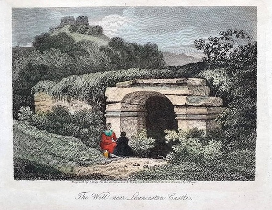
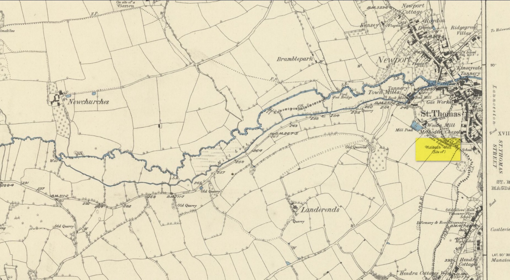
Holy Well (destroyed): OS Grid reference – SX 3285 8477
Archaeology & History
Very little is known about this holy well on the north-western side of town that was apparently destroyed sometime in the 19th century; for when the Ordnance Survey lads visited here in 1882, they found no running water but only the location of where it had been and they indicated this on their 1884 map of the area, marked as “Site of.”
Site of well on 1884 map
It was first mentioned in a short topographical notice in 1582, which told that the “Magden Well in the Quarrie Haye”—along with another well—was “found to be in decay.” (Peter 1885) Then, when the Ordnance Survey lads resurveyed the area once more in 1951, they could find no trace of it. It was mentioned in passing in Peter’s (1885) local history work, but there seems to be little else written about the place, which is a little odd for this part of the world. Anyone know anything more…?
References:
Peter, Richard, The Histories of Launceston and Dunheved, W. Brendon: Plymouth 1885.
Acknowledgements: Big thanks for use of the early edition OS-map in this site profile, Reproduced with the kind permission of the National Library of Scotland.
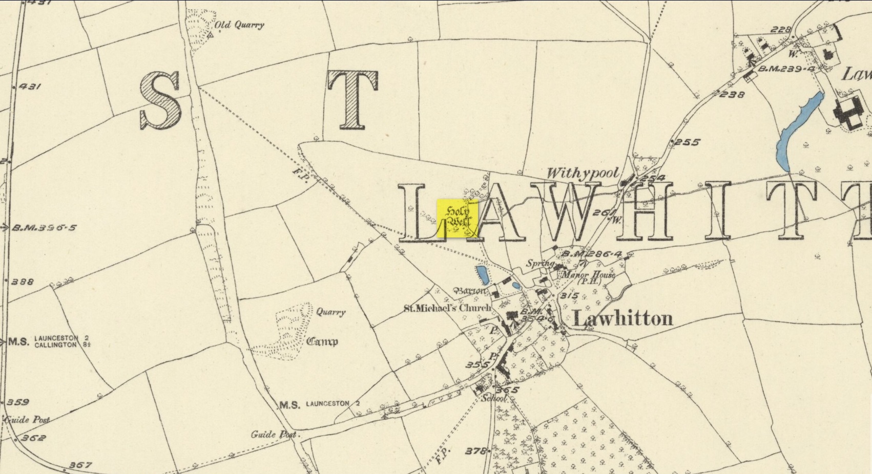
Highlighted on the 1882 OS-map several hundred yards north of St. Michael’s church, this site seems to have fallen back to Earth as no remains of it have been found in recent visits. It was described in Charles Henderson’s (1914) notes as the “holy well at Barton Farm”, and was visited by J. Meyrick (1982) in April of 1980, who told that it could be found by taking “the track immediately east of Lawhitton church which runs through the farm of Mr Lancaster… After going through the yard proceed ¼ mile down track to the valley where you reach a stream and the Well is on the right.” It was sought after by Cheryl Straffon (1998) but following her visit to find the Well she told that “there was nothing now to see except a kind of natural basin by the small bridge.”
References:
Henderson, Charles, Notebooks of Parochial Antiquities, Unpublished MS 1914.
Meyrick, J., A Pilgrims Guide to the Holy Wells of Cornwall, Falmouth 1982.
Straffon, Cheryl, Fentynyow Kernow: In Search of Cornwall’s Holy Wells, Meyn Mamvro: Penzance 1998.
Acknowledgements: Big thanks for use of the early edition OS-map in this site profile, Reproduced with the kind permission of the National Library of Scotland.
Tumulus (destroyed): OS Grid Reference – TQ 861 862
Archaeology & History
Somewhere beneath the modern housing estate immediately east of Chalkwell Park was once a large prehistoric burial mound. It was included in Wymer & Brown’s (1995) archaeological gazetteer (albeit at the wrong spot) without comment, but their reference led me to an early description of the place by Philip Benton (1867) whose description gave us the best info we have of the place. He wrote:
“To the east of the present mansion, at the north-west comer of a field called Fishponds, is a tumulus or mound, probably Celtic. This was first opened about thirty years ago, when bones, a few coins, and a piece of chain were discovered. Since which period about eight feet of earth has been removed from the summit, when more bones were found, but as they were not inspected by any one competent to give an opinion, it is impossible to say whether they were those of man or beast. The mound is still about four feet above the surrounding soil, and would probably repay further search.”
Wymer and Brown listed the site as being an “early Bronze Age” monument.
References:
Benton, Philip, The History of Rochford Hundred – volume 2, Harrington: Rochford 1867.
Wymer, J.J. & Brown, N.R., Excavations at North Shoebury, East Anglian Archaeology: Chelmsford 1995.
Holy Well (destroyed): OS Grid reference – TQ 3337 8245
Archaeology & History
Holywell Lane on 1877 map
First described at the beginning of the 12th century as “fons qui dicitur Haliwelle“, these sacred waters were thereafter described in a variety of documents before eventually, in 1382, giving its name to the road on which it was found. When the topographer John Stow (1603) described the well—along with those of St. Clement’s and Clerken Well—it was once “sweet, wholesome, and clear” and “frequented by scholars and youths of the city in the summer evenings.” However, in his day it was already in decline, as he told that the “Holy well is much decayed and spoiled, with filthiness purposely laid there, for the heightening of the ground for garden plots.”
The history of the site was mentioned in John Noorthouck’s (1773) survey, where he told us:
“In the parish are two prebends, and part of a third, belonging to St Paul’s cathedral, in the city of London: The first dominated by Eald-Street, or Old Street, received that appellation from the Saxons being part of the Roman military way: the second, which had been a separate village for many years, by the name of Hochestone, vulgarly Hoxton, likewise itself to be of a Saxon origin: the third called Haliwell, had its name from a vicinal fountain, which, for the salubrity of its water, had the epithet Holy conferred on it.
In King John’s Court, Holywell-lane, are to be found the ruins of the priory of St. John Baptist, of Benedictine nuns, founded by Robert the son of Gelranni, prependary of Haliwell, and confirmed by charter of Richard I in the year1189. It was rebuilt in the reign of Henry VII by Sir Thomas Lovell, knight of the garter; who was there buried: and the following ditty was in consequence painted in most of the windows.
“All the nuns of Holywell,
“Pray for the soul of Thomas Lovell.”
The complete demise of the well occurred in the early part of the 19th century and efforts to locate its original position have proved troublesome. Indeed, the modern Holywell Lane would seem to be little more than an approximation of its whereabouts. It was an issue explored at some length in the great A.S. Foord’s (1910) magnum opus, who wrote:
“In recent times efforts have been made to locate the well, and some of the results communicated to Notes and Queries. A Mr. R. Clark drew attention, through the medium of that publication, to an article in The Builder of September 19, 1896, which states that ”the ancient holy well should be looked for in the area between Bateman’s Row and New Inn Yard and behind the Board School in Curtain Road, that is to say, west of New Inn Street.” This is all very circumstantial, but the writer bases his statement on the survey by Peter Chassereau, taken in 1745, in which the supposed position of the well is marked by a cross and the words “Ye well from which the liberty derives its name.” It should be borne in mind however that, as pointed out by Colonel W. F. Prideaux, Chassereau did not make his survey till more than two hundred years had elapsed from the date of the dissolution of the Nunnery (1539); the position of the well could therefore have been only a matter of tradition. Another contributor to Notes and Queries (8th Series, May 22, 1897), quotes an article in the Journal of the Royal Institute of British Architects (vol. iv., 3rd series, p. 237), by Mr. E. W. Hudson, who says that the well of the priory was situate on the south side of what is known as Bateman’s Row, but was formerly (before 1799) called Cash’s Alley, near Curtain Road. This agrees substantially with Mr. Clark’s statement. Mr. Lovegrove, writing in 1904, says: “The well itself is to be found in a marble-mason’s yard in Bateman’s Row, but is covered over.” The same writer notes that of the Nunnery buildings only a piece of stone wall about 50 feet long, in a timber yard at 186, High Street, Shoreditch, is now left.”
References:
Foord, Alfred Stanley, Springs, Streams and Spas of London: History and Association, T. Fisher Unwin: London 1910.
Gover, J.E.B., Mawer, Allen & Stenton, F.M., The Place-Names of Middlesex, Cambridge University Press 1942.
Lovegrove, G.H., “Holywell Priory, Shoreditch,” in Home Counties, volume 6, 1904.
Mills, A.D., A Dictionary of London Place-Names, Oxford University Press 2001.
Noorthouck, John, A New History of London, Including Westminster and Southwark, R. Baldwin: London 1773.
Stow, John, A Survey of London, John Windet: London 1603.
Sunderland, Septimus, Old London Spas, Baths and Wells, John Bale: London 1915.
Wood, Alexander, Ecclesiastical Antiquities of London, Burns & Oates: London 1874.