Lexden Tumulus, Colchester, Essex

Tumulus:  OS Grid Reference – TL 975 247

Getting Here

Fortunately for the person who lives here, this much overgrown and denuded remains of a fabled tumulus is in their garden!  The mound is divided by a hedge in the back garden, up near the bend of where Fitzwalter Road meets St. Clare Road and the school field backs onto them.  I’ve no idea whether the people who own the gardens are OK with you visiting the site or not. If you wanna look at it, I s’ppose the only thing to do is knock on their door and ask!

Archaeology & History
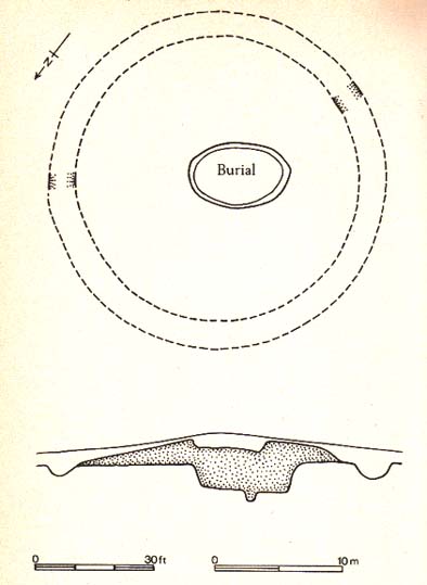
Plan of the Lexden tumulus (Laver, Archaeologia 1927)

Ascribed as late Iron Age, some of the finds here are distinctly Romano-British.  Indeed, excavations here by P.G. Laver in 1924 uncovered rich Belgic remains akin to the chariot burials found in East Yorkshire! (though not quite as good as them)  There was a considerable collection of gold, silver and other metalwork remains here, along with considerable remains of pottery aswell.  It seems there was a tradition of burials here, with some evidence dating from the Bronze Age — but the majority of remains found in the excavations were from the much later period.  One account attributes the burial mound to have held the body of Cunobelin; the other, the body of Addedomaros of the Trinovante tribe.

Folklore

Quoting from an earlier source (A.H. Verrill’s Secret Treasure, 1931), in Leslie Grinsell’s (1936) fine early survey on British prehistoric tombs, he described the legend of there being hidden treasure here, saying that locally there was

“a belief that it was the burial place of a king in golden armour, with weapons and a gold table.”

But was this legend described anywhere before P.G. Laver’s excavation of the site in 1924…?  It would be very intriguing if we could find this out!

References:

  1. Grinsell, Leslie V., Ancient Burial Mounds of England, Methuen: London 1936.
  2. Laver, P.G., ‘The excavation of a Tumulus at Lexden, Colchester,’ in Archaeologia journal, no.76, 1927.

Links:

  1. Unlocking Essex’s Past: The Lexden Tumulus & Associated Cemetery

© Paul Bennett, The Northern Antiquarian


Ring Hill, Littlebury, Essex

Hillfort:  OS Grid Reference – TL 515 382

Also Known as:

Getting Here

You can’t really miss this.  Roughly halfway along the B1383 London Road between Littlebury and Wendens Ambo, just above Chestnut Avenue, a dirttrack on the west-side of the road takes you up and onto the wooded hillside. Where the track splits in two, head straightforward up and into the trees until it opens into the clearing. You’re there!

Archaeology & History

This great monument had already been described several times before the Domesday Book had even been thought about!  Indeed, it seems that the town itself gets its name from the hillfort! (Reaney 1935)  Nowadays the place is just about overgrown and covered in woodland.  You cna make out various undulations where parts of the ditches are apparent, but it could do with a clean-out.  Thought to be Iron Age, Nick Thomas (1977) described the site as,

“Oval in plan, this fort follows the contour of the hill it encloses, protecting about 16½ acres… the defences consist of a bank, ditch and counterscarp bank, of which only the ditch is well-preserved.”

References:

  1. Reaney, Paul, The Place-Names of Essex, Cambridge University Press 1935.
  2. Thomas, Nicholas, Guide to Prehistoric England, Batsford: London 1977.

Links:

  1. Ring Hill, Littlebury

© Paul Bennett, The Northern Antiquarian

North Ring, Mucking, Stanford-le-Hope, Essex

Enclosure (destroyed):  OS Grid Reference – TQ 675 811

Archaeology & History

North Ring, Mucking (after Brown, 2001)

This large circular enclosure, measuring about 120 feet across, seemed to be a small settlement with several internal structures (fences, pits, cremations and a sunken-floored structure) that was first excavated in 1978 and described as a Bronze Age enclosure.  Akin to a henge monument in some ways, this small settlement site had two entrances: one on the east and the other opposite on its west side.  However, the main ‘entrance’ was on the eastern (sunrise) side, where post-holes laid a pathway over the ditch and into the structure itself.

The excavation on the eastern side of site revealed two periods of construction with associated structures, including three circular buildings.  Some excavations to the east produced evidence for a range of contemporary activities.  The assemblage of Late Bronze Age material included pottery, metalwork, cremation remains, sickle moulds and equipment for salt production.  For further info and imagery, see the Link below.

References:

  1. Bond, Dermot, Excavation at the North Ring, Mucking, Essex, East Anglian Archaeology 1988.
  2. Brown, N., “The Late Bronze Age Enclosure at Springfield Lyons in its Landscape Context,” in Essex Archaeology & History, volume 32, 2001.

Links

  1. North Ring, Mucking

© Paul Bennett, The Northern Antiquarian


Springfield Lyons, Chelmsford, Essex

Enclosure:  OS Grid Reference – TL 7357 0818

Archaeology & History

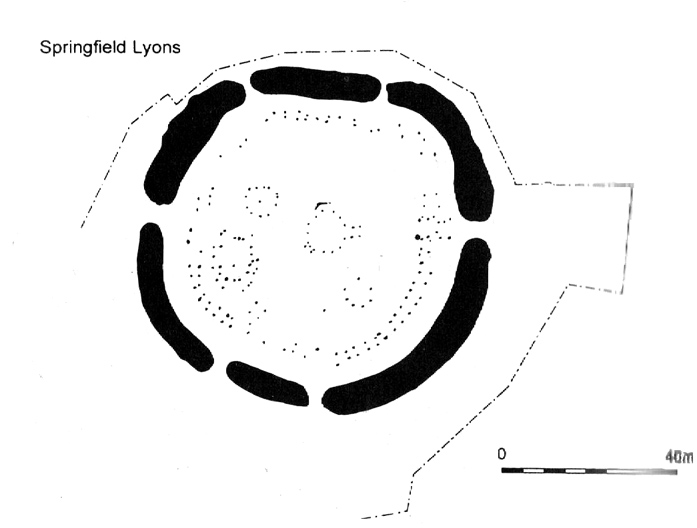
Springfield Lyons enclosure (after Brown, 2001)

We’ve known that there was an excessive number of prehistoric archaeological sites in and around the Chelmsford region for quite a long time now, but defining precisely the age and nature of the finds takes some doing! (as you’d expect)  It hasn’t helped, of course, with the housing estates and other ecologically destructive building operations in and around the area, screwing up a more accurate and patient assessment of the material there.  And this predicament was exemplified with the Springfield Lyons neolithic causewayed enclosure just as much as at the Springfield Cursus and other sites nearby.

Although excavations here found a large, deep ditch with impressive ramparts and entrance, in Oswald, Dyer & Barber’s (2001) survey of these giant monuments, they defined the remains here as “probable,” pending further investigations.  But the site was primarily defined by the large deep ditch, broken in several places round its edges with the ’causeways’ built leading onto the site.  The enclosure gave good views over the small valley from here and had streams running either side of it.

Adjacent to the site were the remains of a “small circular enclosure with multiple entrances,” saying that excavation here,

“has proved that it is of late Bronze Age date and might be interepreted variously as a defended settlement, or a ritual monument.”

This external small enclosure site was then conjectured, quite spuriously it’s gotta be said, to be a mini-version of the great causewayed enclosure monument, saying:

“Its siting and form both hint that it could have been a conscious imitation of, or re-invention of, the perceived form of the earthworks of the neolithic enclosure.”

I like the idea, it’s gotta be said — but without direct evidence we’ve gotta take this idea with a large pinch of salt!

…to be continued…

References:

  1. Brown, N., ‘The Archaeology of Essex 1500 – 500 BC,’ in Bedwin, O. (ed.), The Archaeology of Essex, ECC: Chelmsford 1996.
  2. Brown, N., “The Late Bronze Age Enclosure at Springfield Lyons in its Landscape Context,” in Essex Archaeology & History, volume 32, 2001.
  3. Oswald, Alastair, Dyer, Caroline & Barber, Martyn, The Creation of Monuments: Neolithic Causewayed Enclosures in the British Isles, EH: Swindon 2001.
  4. Priddy, D., ‘Excavations in Essex, 1987,’ in Essex Archaeology & History, 19, 1988.

© Paul Bennett, The Northern Antiquarian


St. Osyth’s Well, St. Osyth, Essex

Holy Well:  OS Grid Reference – TM 116 166

Archaeology & History

This spring of water is in the edge of Nun’s Wood on the north side of the Dolphin Pond pool and is covered by a small stone building, from which issues a small stream into the lake.  Remains of an old nunnery in the woods are said to be the oldest such monastic remains in England.

Folklore

This holy well, the woods in which it’s found, and the old straight road leading to the chapel,* are all said to be haunted by the headless ghost of old St. Osyth, beheaded — in one legend — by the Danes who came here in the 7th century.  At the spot where she’s said to have received her final fatal blow, the waters from this now bricked-up old well gushed forth from the Earth. (Prior to this, folklore tells how St. Osyth was ‘killed’ several times, and each time came back to life – just as in shamanic lore, from which such early christian tales were glossed onto.)

Of it medicinal virtues, Robert Charles Hope (1893) told us that St. Osyth’s Well had been blessed by many a sufferer who found there a medicine for his ills, and at that time, “continues to this day as a sovereign remedy for many diseases.”

References:

  1. Hope, R.C., Legendary Lore of the Holy Wells of England, Elliott Stock: London 1893.

* I’m presuming that the old road to the chapel here is the long straight grove of trees which ran from St. Osyth’s Chapel and up towards the well. Anyone know for sure?

© Paul Bennett, The Northern Antiquarian