Ellers Wood (614), Washburn Valley, North Yorkshire

Cup-and-Ring Carving:  OS Grid Reference – SE 1895 5099
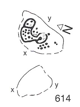
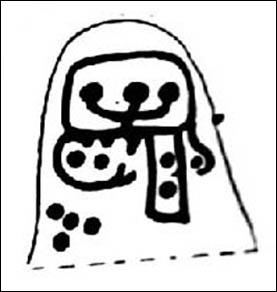
Ellers Wood carving 614 (after Boughey & Vickerman)

Getting Here

Ellers Wood is at the very northern edge of the beautiful parish of Askwith and has a very particular ambience of its own. The small cluster of at least 5 cup-and-ring stones in this lovely little woodland gives you the impression that they stood out on their own, living here representing the genius loci of this luscious watery vale, all-but-hidden from all but the lucky few.  It’s very likely that there are still more carvings hidden away nearby.

The best way to check them out is simply to walk down past the haunted Dobpark Lodge, where it turns into a footpath and where it crosses the lovely old packhorse bridge at the valley bottom, walk a few hundred yards up the river-side (at the bottom of the fields) until you reach Ellers Wood. Once there, look around.  This one’s on the west side of the main stream, close by where it meets up with another small burn coming down from the western wooded slopes.


Archaeology & History
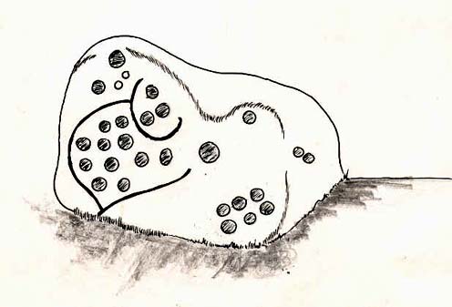
First sketch of the carving, c.1994

In the same region as the Ellers Wood 618 and other carvings and very close to the river, somehow this heavily cup-marked stone evaded the prying eyes of such notaries as Cowling, Stuart Feather and Sidney Jackson – all of whom ventured to look at the other petroglyphs in Ellers Wood.  But with good fortune, Graeme Chappell and I re-discovered this fine-looking carving in our explorations in 1993-94 and gave it back the attention it truly deserves.

The main feature here is the clustering of cups into sections, as the drawing indicates.  It is listed as “stone 614” in Boughey & Vickerman’s (2003) survey.

References:

  1. Boughey, K.J.S. & Vickerman, E.A., Prehistoric Rock Art of the West Riding, WYAS: Exeter 2003.
  2. Cowling, E.T., ‘A Classification of West Yorkshire Cup and Ring Stones,’ in Yorks. Arch. Journal 1940.
  3. Cowling, Eric T., Rombald’s Way, William Walker: Otley 1946.
  4. Cowling, E.T. & Hartley, C.A., ‘Cup and Ring Markings to the North of Otley,’ in Yorks. Arch. Journal 33, 1937.
  5. Grainge, William, The History and Topography of the Forest of Knareborough, J.R. Smith: London 1871.
  6. Grainge, William, History and Topography of the Townships of Little Timble, Great Timble and the Hamlet of Snowden, William Walker: Otley 1895.

© Paul Bennett, The Northern Antiquarian 

Ellers Wood (619), Washburn Valley, North Yorkshire

Cup-and-Ring Carving:  OS Grid Reference – SE 1902 5102

Also Known as:

  1. Airship Carving

Getting Here

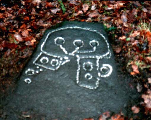
Old photo of CR-619

Follow the same directions for the Ellers Wood 614 and 618 carvings, as it’s nearby. The best way to check them out is simply to walk down past the haunted Dobpark Lodge, where it turns into a footpath and then when you reach the lovely old packhorse bridge at the valley bottom, walk upstream for 3-400 yards until you reach the next small wooded region.  Once there, look around…..

Archaeology & History

Ellers Wood is at the very northern edge of the beautiful parish of Askwith and has a very particular ambience of its own. The small cluster of at least 5 cup-and-ring stones in this lovely little woodland gives you the impression that they stood out on their own, living here respresenting the genius loci of this luscious watery vale, all-but-hidden from all but the lucky few.

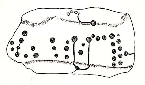
Cowling’s 1937 sketch
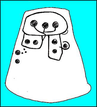
1991 sketch of CR-619

Beautifully preserved, this carving was first described in an article by Cowling & Hartley (1937), then included in Cowling’s Rombald’s Way (1946).  As with the other cup-and-rings close by, the characteristic grouping of certain cups is here focused into three sections by enclosing rings.  This was something I used to call ‘central design’ features, which occur in different locales with their own individual geographical patterns/structures.  These central designs are non-numeric in nature, though have a tendency to cluster in patterns of 2, 3 and 4.  (I need to write a decent essay on this to outline what I’m on about with greater clarity!)

References:

  1. Boughey, K.J.S. & Vickerman, E.A., Prehistoric Rock Art of the West Riding, WYAS: Exeter 2003.
  2. Cowling, E.T., ‘A Classification of West Yorkshire Cup and Ring Stones,’ in Yorks. Arch. Journal 1940.
  3. Cowling, Eric T., Rombald’s Way, William Walker: Otley 1946.
  4. Cowling, E.T. & Hartley, C.A., ‘Cup and Ring Markings to the North of Otley,’ in Yorks. Arch. Journal 33, 1937.
  5. Grainge, William, The History and Topography of the Forest of Knareborough, J.R. Smith: London 1871.
  6. Grainge, William, History and Topography of the Townships of Little Timble, Great Timble and the Hamlet of Snowden, William Walker: Otley 1895.

© Paul BennettThe Northern Antiquarian


Ellers Wood (618), Washburn Valley, North Yorkshire

Cup-and-Ring Carving:  OS Grid Reference – SE 1901 5101

Getting Here

Sketch of CR-618, c.1990

Follow the same directions to reach the other Ellers Woods carvings, staying on the western-side of the river close to where it meets with Snowden Beck, just north of the footpath. Check it out in winter and early Spring — any later in the year and it might be a little overgrown.

Archaeology & History

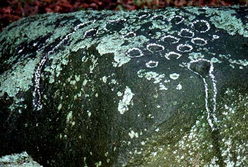
A truly lovely, lichen enriched carved rock in a lovely little part of the Fewston valley.  The place has a distinct genius loci that’s very different from its carved rock companions on the moorland hills a short distance away.  As I’ve said elsewhere: the surroundings of trees and richer fertile growth is something we must remember to ascribe to these carvings when we encounter them, as the landscape in places such as Ellers Wood is much closer to the scattered forested landscape that profused when first these stones were inscribed.

Section of CR-618

First described by Cowling & Hartley in 1937, it was later included in Cowling’s (1946) more extensive prehistoric survey of mid-Wharfedale.  There may be as many as 38 cup-markings cut onto the rock here, along with several lines and grooves.  A meditative dreaming site indeed…

References:

  1. Boughey, K.J.S. & Vickerman, E.A., Prehistoric Rock Art of the West Riding, WYAS: Exeter 2003.
  2. Cowling, E.T., ‘A Classification of West Yorkshire Cup and Ring Stones,’ in Yorks. Arch. Journal 1940.
  3. Cowling, Eric T., Rombald’s Way, William Walker: Otley 1946.
  4. Cowling, E.T. & Hartley, C.A., ‘Cup and Ring Markings to the North of Otley,’ in Yorks. Arch. Journal 33, 1937.
  5. Grainge, William, The History and Topography of the Forest of Knareborough, J.R. Smith: London 1871.
  6. Grainge, William, History and Topography of the Townships of Little Timble, Great Timble and the Hamlet of Snowden, William Walker: Otley 1895

© Paul BennettThe Northern Antiquarian


Dove Stones, Thornton Rust Moor, North Yorkshire

Cup-Marked Stone:  OS Grid Reference – SD 96634 87493

Also Known as:

  1. DS3 Carving (Brown & Brown, 2008)

Getting Here

Takes a bitta finding and aint too accessible for those of you who need footpaths!  Below the eastern slopes of Addlebrough Hill, by the present source of the Gill Beck right beneath the Dove Stones (the water tastes gorgeous), are the ruinous remains of an old sheepfold. In the field immediately behind (south) of here are a number of small rocks.  Look around and you’ll find the stone in question!

Archaeology & History

Unless you’re a real rock-art-freak, I can’t imagine too many of you checking this one out!  When Richard Stroud and I visited this spot a few years back (2006), it was a mixture of love and madness that brought us here!

Dove Stones Carving
Dove Stones Carving

Amidst the many stones scattered hereabouts, one of them possesses two clear cup-marks on a stone measuring roughly 3ft by 2ft, along the line of a much ruined ancient wall.  This might be the one that Beckensall and Laurie (1998) described in their Prehistoric Rock Art of County Durham, Swaledale and Wensleydale, as “a rock with several cups (which) has recently been noticed on Thornton Rust Moor, near the Dovestones” — though it seemed blatantly apparent to us that there were only two cups here, not “several”.  However, Brown (2008) appears to list the site, citing it as having “two cups”, just like the one we found, and being “found in prehistoric low field settlement wall,” which fits the picture perfectly — although Brown gives a slight difference in grid-reference to the one Richard Stroud took.  It looks a good area to scout around and, I reckon, find previously unrecorded sites.

References:

  1. Beckensall, Stan & Laurie, T., The Prehistoric Rock Art of County Durham, Swaledale and Wensleydale, County Durham Books 1998.
  2. Brown, Paul & Barbara, Prehistoric Rock Art in the Northern Dales, Tempus: Stroud 2008.

© Paul Bennett, The Northern Antiquarian

Dewbottoms, Arncliffe, North Yorkshire

Settlement:  OS Grid Reference – SD 9132 6950

Getting Here

From Grassington go north up the B6160, turning left to Arncliffe, and parking up by the pub.  Take the footpath past it and onto the rocky ridge to your SW for a mile-and-half.  Dew Bottoms settlement is on the wide ridge between the two decent streams dropping back into the valley road below.  Look round!

Archaeology & History

The remains of this prehistoric settlement first seem to have been described by Arthur Raistrick and Paul Holmes. (1961)  They told that:

“the principal field is approximately 120 feet square, enclosed by a massive boulder and gravel bank, probably the foundation of a substantial stockade.  The field is now mostly bare limestone pavement.  Four smaller fields adjoin it on the north and west.  Circular huts with drystone walls still about 3 freet 6 inches high before excavation, covered by collapsed material suggesting an original height of 5 feet, are placed, two of them in the course of the field wall and two in the junction of three field walls.  The huts are about 10 feet internal diameter, the walls about 3 feet thick.  A very fine quartzite hone was the only find in the huts.  There are two rectangular stone-built enclosures, 20ft by 10ft, and 15ft by 8ft, and several small rectangular enclosures, probably buildings, with walls of boulders and turf, using one wall of a field as a common back wall.  The whole site suggests a compact family farm.”

A few years later the site was visited and later described by Miss D. Charlesworth at the annual meeting of the Archaeological Society in July 1968, and is one of several found on the hills 2-3 miles southwest of Arncliffe village. Miss Charlesworth told:

“This site also faces north and covers an area of about 330 by 280ft, much of it now bare limestone. There are eight rectangular buildings and four circular huts associated with a large enclosure about 120ft square, with five smaller enclosures adjoining it.”

References:

  1. Charlesworth, D., ‘Iron Age Settlements and Field Systems,’ in Proceedings of the Archaeological Journal, 125, 1968.
  2. Raistrick, Arthur & Holmes, Paul F., Archaeology of Malham Moor, Headley Brothers: London 1961.

© Paul BennettThe Northern Antiquarian


Devil’s Stone, Addlebrough, Bainbridge, North Yorkshire

Legendary Rock:  OS Grid Reference – SD 943 880

Getting Here

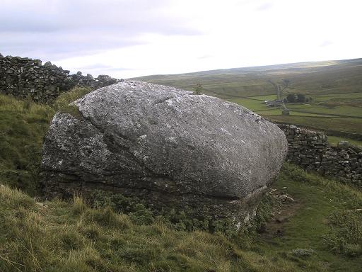
From the small town of Bainbridge, head south down the Carpley Green Road. Less than a mile before the end, look to the west-facing slope of Addlebrough Hill and this huge Devil’s Stone can be seen resting halfway up the slope.

Archaeology & History

Devil's Stone, Addlebrough
Devil’s Stone, Addlebrough

One of the legends of this place suggested there might be cup-and-ring markings on the stone, but the curious markings on top of the rock seem to be natural.  It’s a superb stone though, dropped here no doubt by some great glacier as it retreated north, in ages truly olde…

There’s a lot of archaeology round here that aint in the books.  We’ve come across some intriguing stuff of late, which you’ll read about soon enough.

Folklore

One legend tells that long ago Addlebrough was the home of a great unnamed giant — but a friendly giant by all acounts.  However, one day the devil turned up and wanted possession of the giant’s hill and so a fierce row broke out between them.  Perched on the top of the crag — which is the rough ridge to the west of here — the giant who lived here hurled huge boulders down at the devil, but they fell short and landed at the side of Lake Semerwater (itself an important spot in local prehistory).  In return, Old Nick himself began throwing boulders back — and one of those which the devil threw landed here, halfway up the western flank of Addlebrough Hill (a couple of the large granite boulders which the giant threw can be seen on the edge of Semerwater and are known as the Carlow and Mermaid stones).  Hence it’s name of the Devil’s Stone!

In Edmund Bogg’s Richmondshire (1908), he told how, “the curious markings on (the Devil’s Stone) are accounted due to the pressure of the devil’s fingers” which were caused when he threw this giant stone from somewhere to here.

This is a theme we find at countless other stone sites, i.e. the Devil burning holes into rock — and in some cases these devil’s “fingerprints” have turned out to be prehistoric cup-markings.  Such tales relate to the pre-christian Creation Myth of a place and would, before the “devil” was supplanted onto a site, have had wider significance in the landscape as a whole, in a manner known to the local people.  Devils usually replaced legendary giants, or hero-figures, who created the land in primordial times according to the myths of our ancient ancestors.  A greater examination of the nearby sites in association with the folklore of the region would no doubt be quite profitable…

References:

  1. Bogg, Edmund, Richmondshire, James Miles: Leeds 1908.

© Paul Bennett, The Northern Antiquarian

Devil’s Apronful, Appletreewick, North Yorkshire

Cairn:  OS Grid Reference – SE 07485 59355

Getting Here

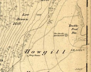
Devils Apronful on 1853 map

An excellent spot with fantastic views. There’s many ways to approach the place, but a good one is from the roadside by Howgill, then following the track uphill until you reach the moor, then head towards the spectacular and legendary, Simon’s Seat (which folklore ascribes to be named after the great druid, Simon Magus). You’ll pass an old Grey Stone (two large rocks) from which you can espy the old tomb if you stand on top of ’em. Keep walking uphill and it’s about 100 yards off the footpath to your right. A large boulder is nestled just beneath the tomb itself, which stands out on a ridge.

Archaeology & History

When Harry Speight visited here (1900) he described it as being 40 yards in circumference. He also described “an upright stone below the cairn” with apparent cup-markings on the west-side.  I’m not quite sure where this has got to – but the site has shrunk somewhat since Speight’s day.  It’s only about 20 feet across now, and the middle of it has been hollowed into a grouse-shooting butt for the toffs!

About 100 yards southeast (towards the Truckle Stones) are the remains of some neolithic walling in a straight line.

Folklore

One of many old tombs in our northern hills said to have been created by the devil who, as usual, accidentally dropped some stones he was carrying. The old folklorist Thomas Parkinson (1888) said the following of this place:

“The Apronful of Stones is a group of rocks heaped together in delightful confusion, their disorder and name being thus explained:  Once upon a time—whether when he built the bridge over the valley, or at some other time, the record saith not—the Devil was determined to fill up the ravine, or gill, of the Dibble. For this purpose he was carrying these enormous crags in his apron, when, too intent upon his object to properly observe where he placed his feet, he caught with one foot upon the top of Nursa Knott, and, stumbling, the strings of the apron broke, and the contents were thrown upon the ground as they now appear. It is also said of them that if any of them, even now, were to be removed, they would certainly be brought back to their original place during the succeeding night.”

Another legend tells that the Devil’s Apronful is also the grave of some local unnamed hero.

References:

  1. Parkinson, Thomas, Yorkshire Legends and Traditions – volume 1, Elliott Stock: London 1888.
  2. Speight, Harry, Upper Wharfedale, Elliott Stock: London 1900.

© Paul Bennett, The Northern Antiquarian

Crow Well enclosure, Denton Moor, North Yorkshire

Settlement:  OS grid reference – SE 1417 5199

Getting Here

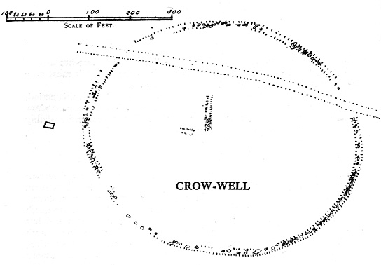
Crow Well settlement (Cowling 1946)

Using the OS-map as a guide, from Denton village head up the road northwest, past Moorside Farm and onto the moor.  Before you reach the rise of Lippersley Pike you’ll reach the Crow Well itself (completely covered over by Yorkshire Water’s handiwork, stopping anyone from drinking the previously fresh waters here).  In the middle of nowhere, just above the completely ruined well, is the old shooter’s cottage and from here, Eric Cowling (1946) told us to look in the heather immediately east. When Richard Stroud and I ventured here a few years back (2.8.5) we couldn’t find a thing — though a vaguely reminiscent structure seemed possible 300 yards away.

Archaeology & History

If the heather’s deep, you’ll have little chance of seeing the site as Eric Cowling (1946) obviously did!  He described and illustrated this place — so was fortunate enough to have ventured here following the heather-burning.

The site is not a stone circle, but what Cowling thought to be an Iron Age settlement: ellipsoid in shape and nearly 400 feet across; it’s obviously an  impressive archaeological site when visible (akin to the Snowden Carr settlement a couple of miles east).  In all probability the site is much earlier than Iron Age.

An aerial image of the site indicates its size to be very close to Cowling’s initial measurements.  The ‘settlement’ is quite huge, with the walling or defining edges being between 4 and 6 yards across in places, with double-walled sections akin to that found at the Brackenhall circle on Shipley Glen, just over 8 miles (13km) to the south.  However, it’s probably much older than its Brackenhall compatriot.  Its maximum diameters measure 130.5 yards (119.3m) roughly east-west and 98.5 yards (90m) roughly north-south, with an external circumference of about 345 yards (315m).  This is a big fella!  Near its centre is a well-defined ring, or ellipse, measuring approximately 20 yards (18.3m) north-south and 18 yards (17.5m) east-west.

It’s difficult to say what this might be without a site analysis, and we need the heather burning back at this site to enable a good inspection of the place!  We may be looking at Denton Moor’s equivalent of the Woofa Bank Enclosure just over 4 miles (6.5km) to the south, above Ilkley, with its host of cup-and-rings and surrounding cairns.  A good inspection of this site is long long overdue…

Hereabouts Cowling also found other remains dating from the neolithic period, including walling, cairns, hut circles and cup-and-ring stones.  He thought that “the name Crow-well appears to be the modern equivalent of ‘the circle of the well'” — and although I doubted this in my Old Stones of Elmet, I have since come to realise the truth of his words!

References:

  1. Bennett, Paul, The Old Stones of Elmet, Capall Bann: Milverton 2001.
  2. Cowling, Eric T., Rombald’s Way: A Prehistory of Mid-Wharfedale, William Walker: Otley 1946.

© Paul Bennett, The Northern Antiquarian

Cleatop, Settle, North Yorkshire

Stone Circle (destroyed):  OS grid-reference – SD 821 613

Also known as:

  1. Druid’s Hill Circle
  2. Druid’s Circle

Archaeology & History

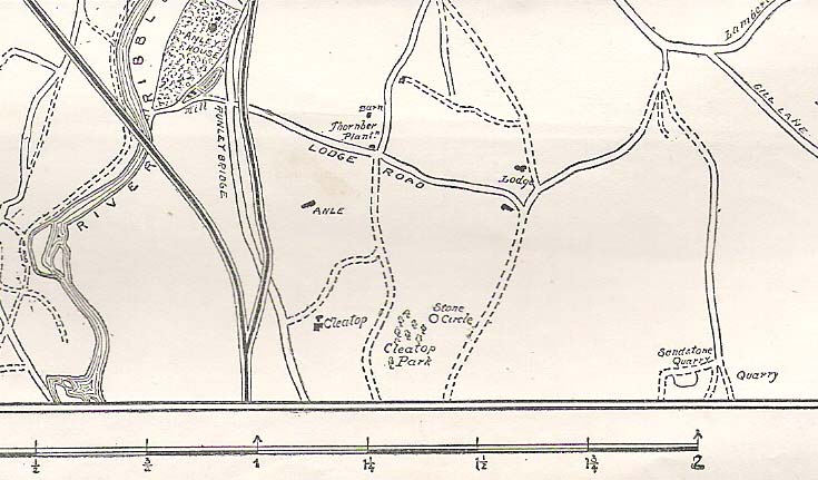
Speight's 1895 map - showing position of circle
Speight’s 1895 map – showing position of circle

Not included in any previous archaeological surveys of megalithic rings, this circle of stones was apparently visible from quite a distance away, sitting on the hillside where now there is woodland.  It was described by the great Yorkshire historian Harry Speight (1892, 1895), though today it seems that all remains of it have vanished.

An early description of it came after an excursion to the site by local antiquarians, who told that “at Cleatop, about a mile to the south of Settle, are the remains of an ancient stone circle.” (Horsfall-Turner 1888) A few years later, Mr Speight gave us more details of the place, saying:

“A little above Cleatop Farm (near Rathmell)…is Cleatop Wood.  Cleatop derives its name from the A.S. cleof, a rocky aclivity; Latin clivus, a bank or slope. Near the northeast side of the wood there was once a very noticeable Druid’s Circle, about 60 feet in diameter; indeed, Mr Thomas Brayshaw of Settle, informs me that within the memory of persons still living, it was so regular and well-defined that one or two gaps caused by the removal of stones could be easily distinguished. The eminence at the rear of the site has, from time immemorial, been known as Druid’s Hill.”

Some years later, that very same local historian Tom Brayshaw (1932) wrote:

“The Ordnance map marks, on the steep slope to the north of Cleatop Wood, ‘site of Stone Circle’.  It needs a very keen eye to identify the few stumps that remain today, and it is deplorable that this most interesting monument, after enduring for so many centuries, has been destroyed during the last eighty years.  In 1847 a description of the circle, as it then was, was sent to Captain Yolland of the Ordnance Survey.

“”I suppose the circle of stones in Cleatop High Park to be aboriginal British or Druidical remains from the following appearances: the circle is complete and the large stones are set on end, some of them several tons weight.  The stones are twelve in number now standing, beside several others that seem to be rolled a short distance, as it is placed on the ascent of a steep hill and commands a beautiful and extensive prospect (more so than any given point of the same altitude in the vicinity).  The circle is 36 feet in diameter.”

“A few stones were still standing in 1883.  The hill above long bore the name Druids Hill.  The Enclosure Acts passed towards the end of the 18th century greatly increased the number of drystone walls in the parish, and it is probable that many old stone monuments were destroyed in making them and in their subsequent repair”.

We have no references of burials or other excavations here to give us any idea of whether human remains had ever been found.  It’s an intriguing place in the landscape though…and worthy of further explorations…

References:

  1. Brayshaw, Thomas, A History of the Ancient Parish of Giggleswick, Halton & Co.: London 1932.
  2. Horsfall-Turner, J. (ed.), ‘Antiquarian Excursion to Giggleswick and Settle,’ in Yorkshire Folklore Journal, vol.1, T. Harrison: Bingley 1888.
  3. Speight, Harry, The Craven and Northwest Yorkshire Highlands, Elliott Stock: London 1892.
  4. Speight, Harry, Tramps and Drives in the Craven Highlands, Elliot Stock: London 1895.

© Paul Bennett, The Northern Antiquarian

Castleberg, Nesfield, North Yorkshire

Hillfort:  OS Grid Reference – SE 0925 4947

Getting Here

Two main ways to get here.  Hmmmm….on second thoughts, one main way.  My preferred route would be from Addingham (east-side) where the foot-bridge crosses the Wharfe.  Walk up the path and, eventually, onto the tidgy road and bear left till you hit the trees.  On the right-hand side of the road you’ll see the trees covering the crop near the edge of the river. …Otherwise, come from Ilkley, cross the river, take the first left, on a few hundred yards and left again on Nesfield Road.  From here, keep walking about a mile and when you hit the village, you need to look into the field behind the first farmhouse on your left.

Archaeology & History

You’ll see the more visible embankments on the western edge of these old earthworks. But unless you’re a real archaeomaniac into depleted field remains, this might not tickle your neurons too much. However, it’s a gorgeous little hamlet is Nesfield – and I think that alone makes it worthy of a visit!

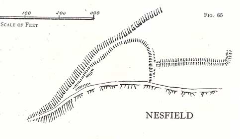
Cowling's 1946 plan
Cowling’s 1946 plan

Described variously over the years as an enclosure, a hillfort, a camp, a settlement – aswell as being ascribed to periods from the medieval, Roman, Iron Age and Bronze, the consensus opinion at the moment edges to it being late Bronze- to early Iron Age in origin.

The fortifications themselves seem to have been first mentioned by T.D. Whitaker in 1812, who said the following:

“Castleberg is in a commanding position, on the brink of a steep slope washed by the Wharfe, about two miles above Ilkley. This post is naturally strong, as the ground declines rapidly in every other direction. But it has been fortified on the more accessible sides by a deep trench, enclosing several acres of ground, of an irregular quadrangular form. At a small distance within the enclosure, an urn with ashes was lately found, but what seems to evince beyond a doubt, the Castleberg was a Roman work, is the discovery of a massy key of copper, nearly two feet in length, which,” he thought, “had probably been the key of the gates.”

This ‘key’ that Whitaker mentioned (if memory serves me right) has been lost and therefore its nature/function lost aswell.  E.T. Cowling (1946) thought the key “may refer to a bronze article of a size which must belong to the Late Bronze Age, when the metal became more plentiful”; thinking it perhaps to be part of a sword.  Twouldst be good to find this artifact and know for certain. Cowling also posited that the urn found here was of Bronze Age origin – an opinion echoed by later archaeologists.

The great Harry Speight (1900) meanwhile, told that the hamlet itself was locally called Castleberg and told us a bit more of the details of the finds, saying:

“I am disposed to think it was a winter-station of the old Britons of Howber, and afterwards of the Teutonic settlers.  An urn containing ashes has been found on the site, and Mr James Pickard, who has long occupied the adjoining farm, tells me he has excavated several parts of it and found human bones, but no relics.  This premises Anglo-Saxon interments and the urn late British…”

References:

  1. Cowling, E.T. Rombald’s Way, William Walker: Otley 1946.
  2. Howson, William, An Illustrated Guide to the Curiosities of Craven, Whittaker: Settle 1850.
  3. Keighley, J.J., ‘The Prehistoric Period,’ in Faull & Moorhouse’s, West Yorkshire, An Archaeological Guide, vol.1, Wakefield 1981.
  4. Speight, Harry, Upper Wharfedale, Elliott Stock: London 1900.
  5. Whitaker, T.D., History and Antiquities of the Deanery of Craven, J. Nichols: London 1812.

© Paul Bennett, The Northern Antiquarian