Take the A59 road from Harrogate and Skipton and at the very top of the moors near the Gill Head Enclosures, take the small Kex Ghyll road up past the disused quarry works north for a mile or so. At the junction go left for about 1½ miles where, on your left, is Burnt House farm. A hundred yards past here is a small spot to park on the right-hand side of the road, opposite the gate to Rocking Hall House (make sure you leave enough room for tractors to pass you!). Across the road is the track to Rocking Hall and, 2 miles along the track, look out for the copse of trees ½-mile NE. Head towards it and, as you get close to the wall, walk slowly downhill towards the stream where a single block of stone lives. You’ll find it!
Archaeology & History
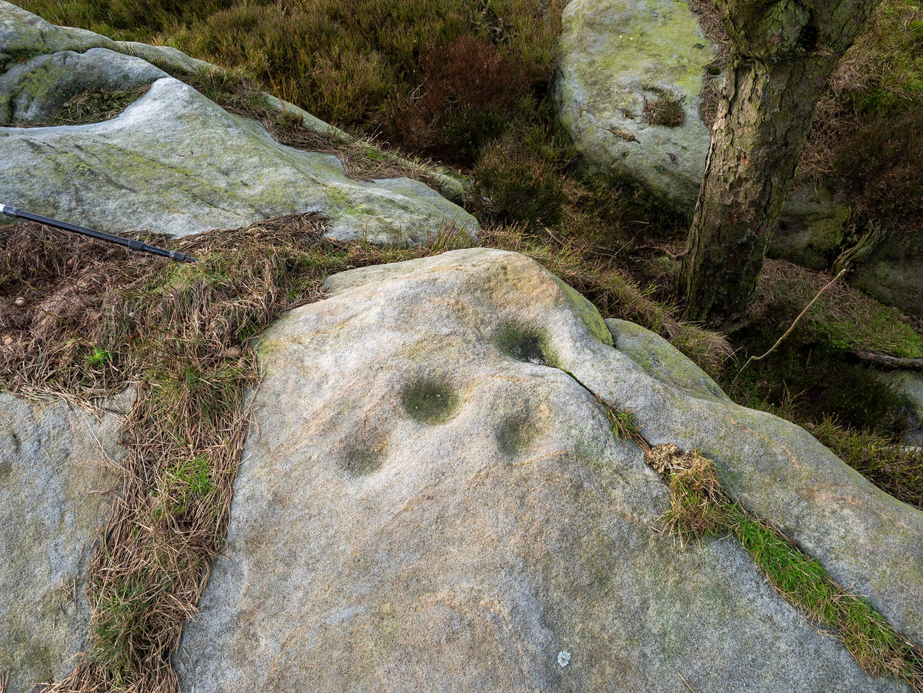
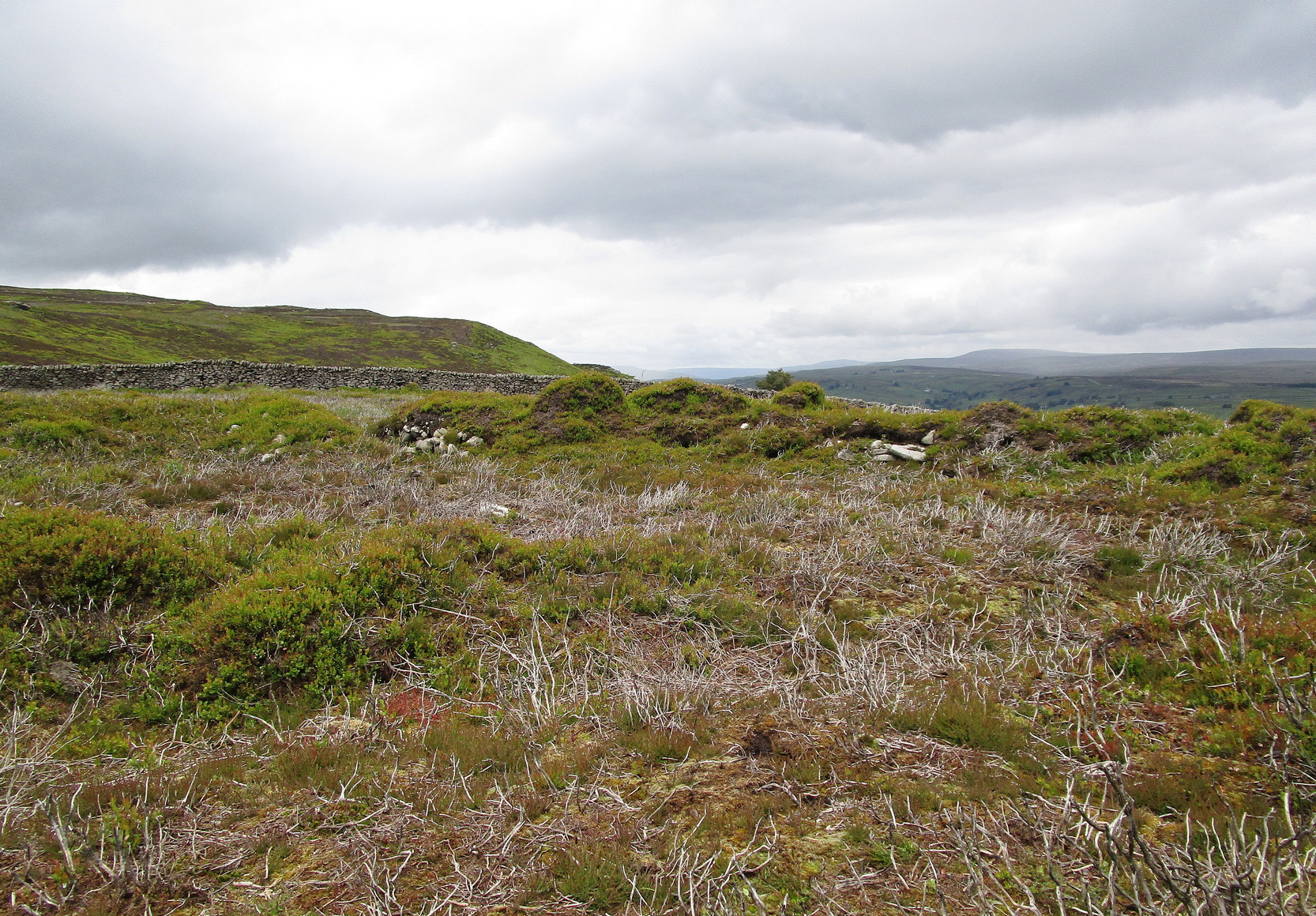
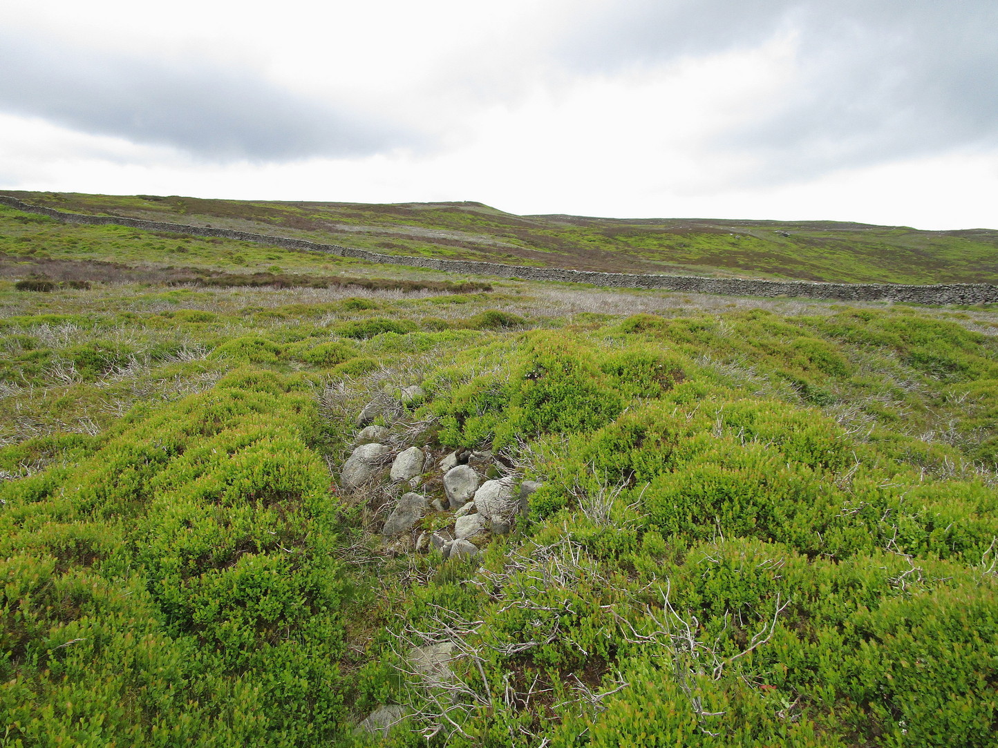
Design from above
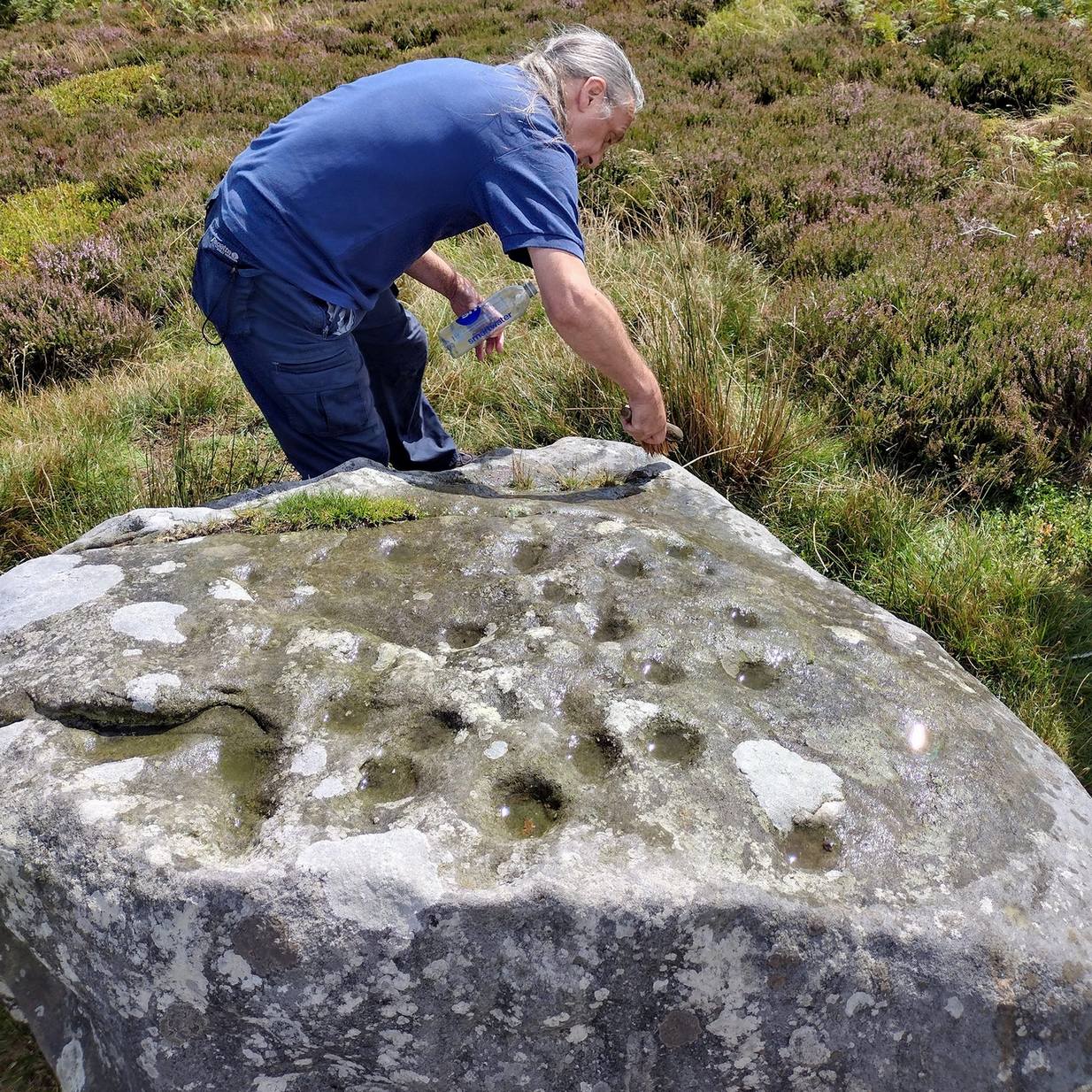
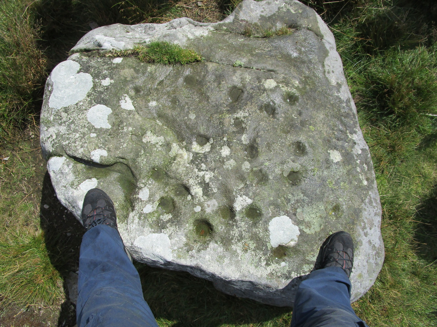
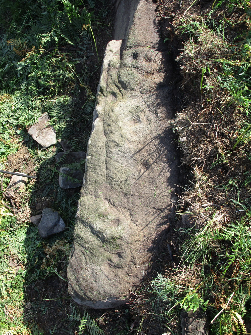
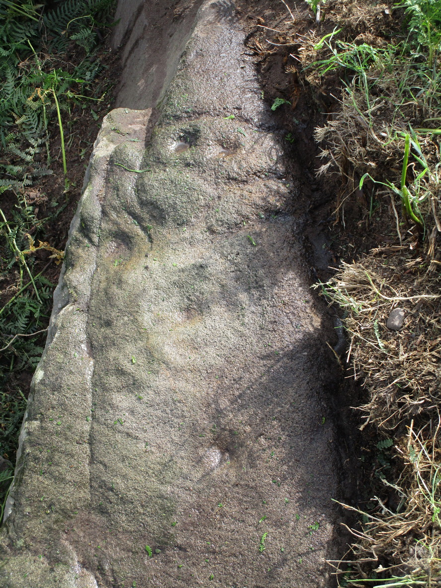
Rediscovered on Rocking Moor by Rod Chambers on August 15, 2023, this reasonably large sloping block of stone has between 21 and 24 cups cut quite deeply and scattered erratically into it, very similar to one some 200 yards to the northwest (Raven Stones carving 559). It seems pretty obvious that some of these cups were Nature’s handiwork, but have been modified by human hands. There’s nothing complex about it, but there may be a semi-circular arc around one of the cups, centre-left of the natural crack that cuts across the top of the stone, but this is very faint and could be just a trick of the eyes. Going there at sunrise and wetting the stone might tell us for sure.
Acknowledgements: Big thanks to Rod Chambers for use of his photo in this site profile.
Coming from Harrogate, take the B6162 and B6161 road to Beckwithshaw, through the village and, 4-500 yards on, turn right onto Norwood Lane. 2 miles along, keep your eyes peeled on your left for a gravelled parking spot and you’ll see the large rock outcrop 200 yards south of the road. …Otherwise, from Otley: go over the river bridge and turn right up Farnley Lane and follow the B6451 for a few miles, thru Farnley village up the Washburn valley, past Norwood and at Bland Hill, turn right along Broad Dubb Road for 1¾ miles where you’ll reach that same gravelled parking spot.
Archaeology & History
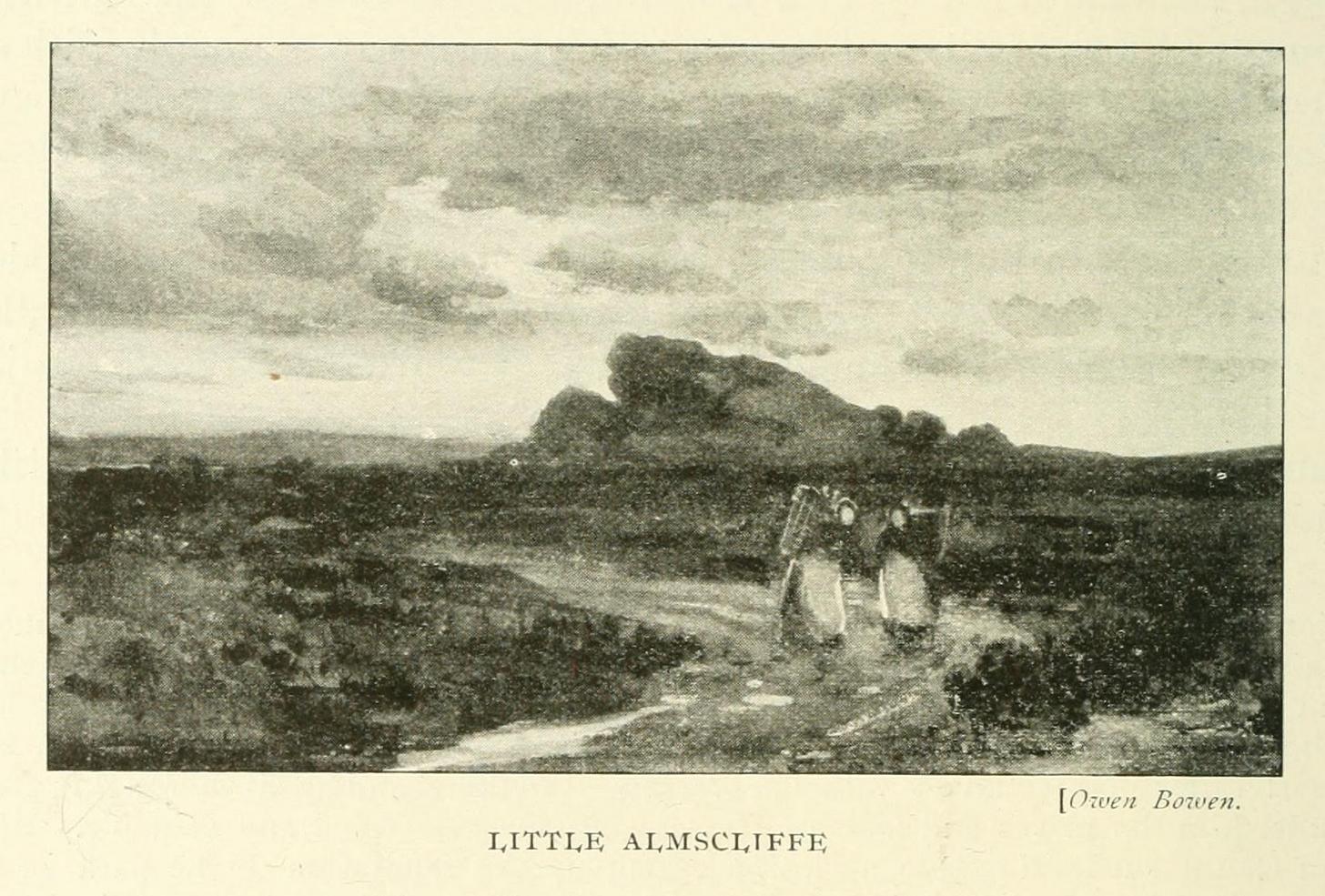
Very much the ‘little brother’ of Great Almscliffe, 3 miles (4.83km) to the southeast, this site would be more of interest to the travelling geologist, perhaps, than to antiquarians. But that depends what tickles y’ fancy I s’ppose.
In 1702 when the northern antiquarian Ralph Thoresby mentioned this and its big brother to the southeast, he described the “two famous crags of Almes Cliff—in some old writings called Aylmoys ut dicitur—but have seen nothing memorial of it, saving its remarkable lofty situation.” He missed the cup-and-ring carving on the east-side of the crags, obviously, which indicates that it had some form of animistic sanctity in ancient times.
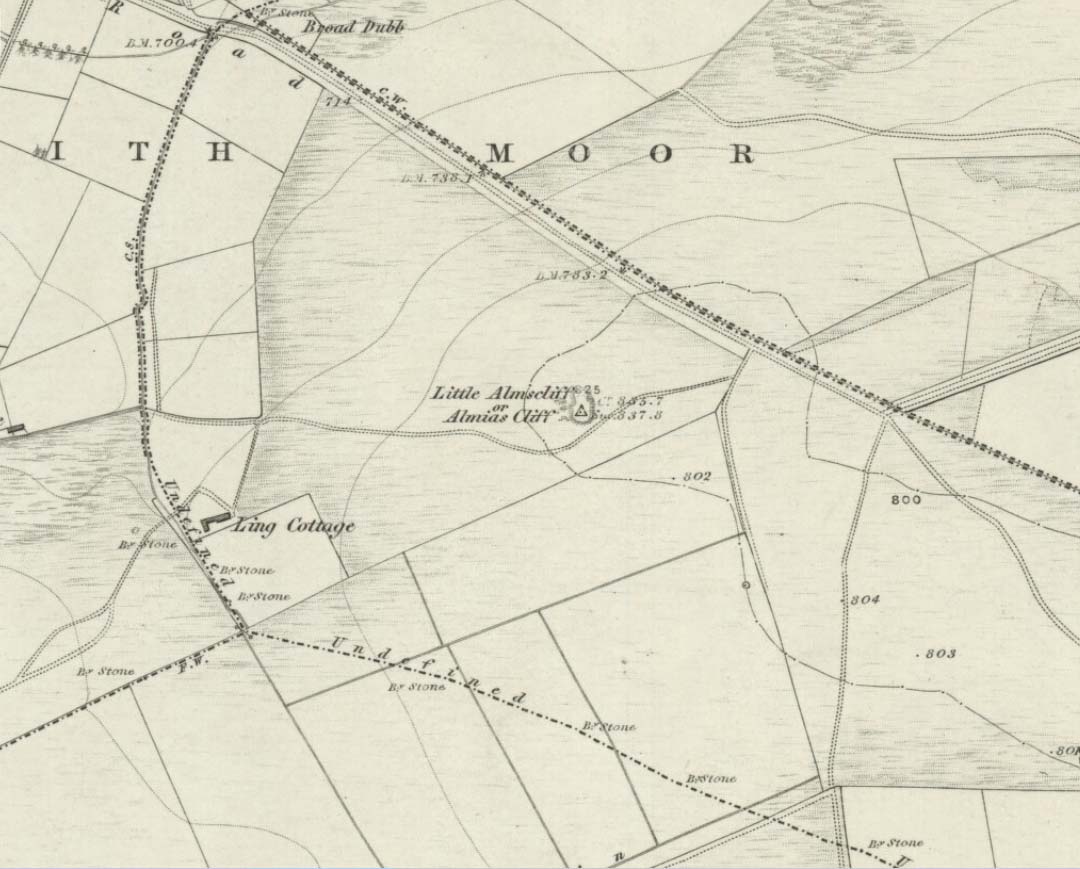
The location on 1851 mapLittle Almscliffe c.1900
Little Almscliffe was one of many impressive places located within the ancient Forest of Knaresborough; and although it wasn’t on the original boundary line, a perambulation (i.e., annual ritual walking to the old stones, trees and wells defining the region) of the area written in 1770, in what Mr Grainge called “the Copyhold Forest”, was undertaken by the Enclosure Commissioners. It differed from the more ancient perambulation rite, in that the newer one included a mention of,
“five bounder stones also marked F to an earth-fast stone, lying northeast of Little Almes Cliffe, marked also with an F; (and) from thence by other four bounder stones marked F to Sandwith Wath…”
The letter ‘F’ here signifying the word ‘forest’, as in the Forest of Knareborough.
William Grainge (1871) also believed these crags to have been a place of druidic worship. He wasn’t the only one. Many other writers of the time thought the same thing; and although we have no concrete evidence to prove this, it is highly likely that these rocks would have served some ritual purpose in pre-christian days. Certainly in more recent times (during the 1980s and ’90s) we know that ritual magickians used this site for their workings. On a more mundane level, the crags were previously used as a site for for beacon fires. One was erected here in 1803 when the first Bonaparte threatened to invade England; but I can find no written accounts of earlier beacons here.
References:
Bennett, Paul, The Old Stones of Elmet, Capall Bann: Milverton 2001.
Bogg, Edmund, From Eden Vale to the Plains of York, James Miles: Leeds 1895.
Bogg, Edmund, Higher Wharfeland, James Miles: Leeds 1904
Cowling, E.T., Rombald’s Way, William Walker: Otley 1946.
Grainge, William, History & Topography of Harrogate and the Forest of Knaresborough, J.R. Smith: London 1871.
Parkinson, Thomas, Lays and Leaves of the Forest, Kent & Co.: London 1882.
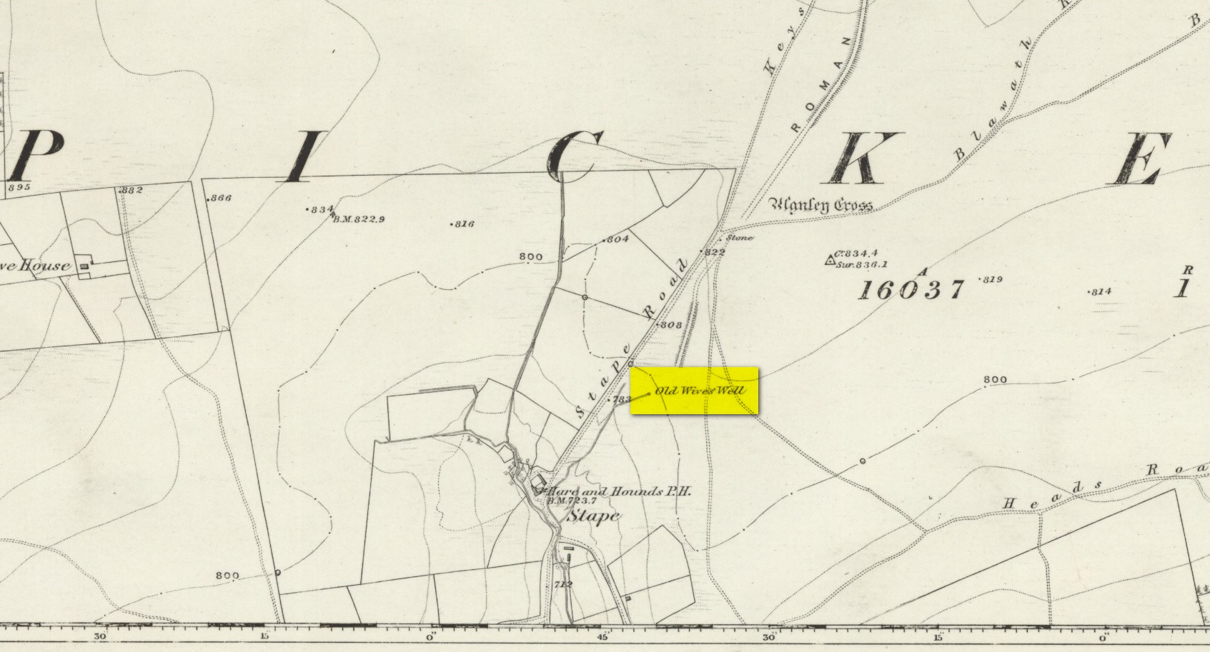
Holy Well (destroyed): OS Grid Reference – SE 2997 5561
Also Known as:
St. George’s Spa
Archaeology & History
About 50 yards away from the Royal Promenade on the east-side of Parliament Street, there used to the flowing water of this old holy well, later becoming one more of Harrogate’s spa wells. It was first recognized as a medicinal spring about 1792 when Thomas Garnett (1794) uncovered it beneath the overgrowth of vegetation surrounding the spring-head. In doing so, it became evident that at some time in the past it had been used by local people as,
“a wall was discovered round the spring, but whether this had been built with an idea of its being a medicinal water, or with an intention of collecting water for cattle, I cannot determine.”
Chalybeate (iron-bearing) in nature, the waters were analyzed by Adam Hunter (1830) in the 1820s and, although possessed of soluble iron, had less than its medicinal compatriots nearby, meaning that its fortifying qualities weren’t quite as good. He told us how,
“it had been known (by locals) for many years, but at no time much used internally; it had acquired some celebrity however as a wash for sore eyes, for which purpose it was well adapted. As chalybeate water has long been a favourite popular remedy for a wash in various weaknesses, and chronic affections of the eyes, it is proper to state that (the nearby) John’s Well, the Tewit Spa, or the succeeding one at Starbeck, are the only three chalybeates which can at present be recommended for that purpose.”
A few years after Hunter had been here, the well was destroyed “by the making of a highway drain.” Jennings 1981)
Folklore
St George (saint’s day – April 23) was one of the christian dragon-killers. There is no known tradition of the saint or festivities that may once have occured here.
References:
Garnett, Thomas, A Treatise on the Mineral Waters of Harrogate, Thomas Gill: Leeds 1794.
Hunter, Adam, The Waters of Harrogate and its Vicinity, Langdale: Harrogate 1830.
Jennings, Bernard, A History of the Wells and Springs of Harrogate, Interprint: Harrogate 1981.
Very little is now known about this sacred site that was once found “a few hundred yards east from the New Church at Low Harrogate.” (Hunter 1830) Even most of travellers and medical experts who wrote about the numerous Harrogate wells in the 18th and 19th century bypassed its quietude; and by the time Mr Hunter wrote about it in his great descriptive catalogue, its healing or medicinal qualities had been forgotten.
He told that “the spirit in the water…or that with which it is infused, has long been most actively engaged in adding real or fancied comforts to the (Harrogate) Fair, and is now in much more general use” than the two other holy wells in the town. It was, he said, “the best water for making tea and more extensively used for that purpose than any in the neighborhood of Harrogate.” It would also appear to have been built over at some time in the not-too-distant past…
Folklore
St Ann (saint’s day – July 26) was a giant in early christian and Islamic myths. An apocryphal figure, She was the Great Mother of the mother of Christ—the Virgin Mary—and was Herself a Virgin until, in Her old age, after seeing a bird feeding a chick, decided She wanted a child and so eventually gave birth to Mary. An old woman giving birth when the Springtime appears (when birds and other animals become fertile) is the same motif found in the lore of the Cailleach in Ireland and Scotland (and parts of northern England). Pre-christian lore at this old well would seem evident here.
References:
Hunter, Adam, The Waters of Harrogate and its Vicinity, Langdale: Harrogate 1830.
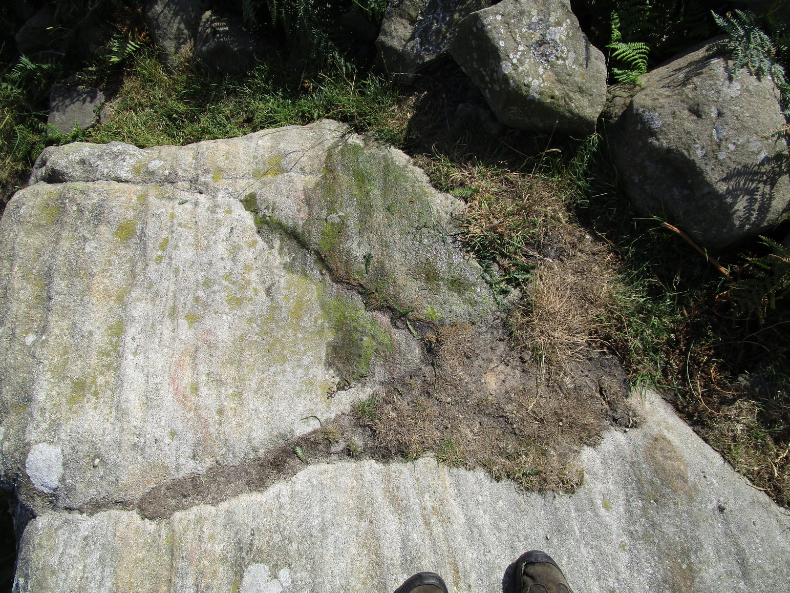
Cup-Marked Stone: OS Grid Reference – SE 1194 5810
Getting Here
The Raven stone setting
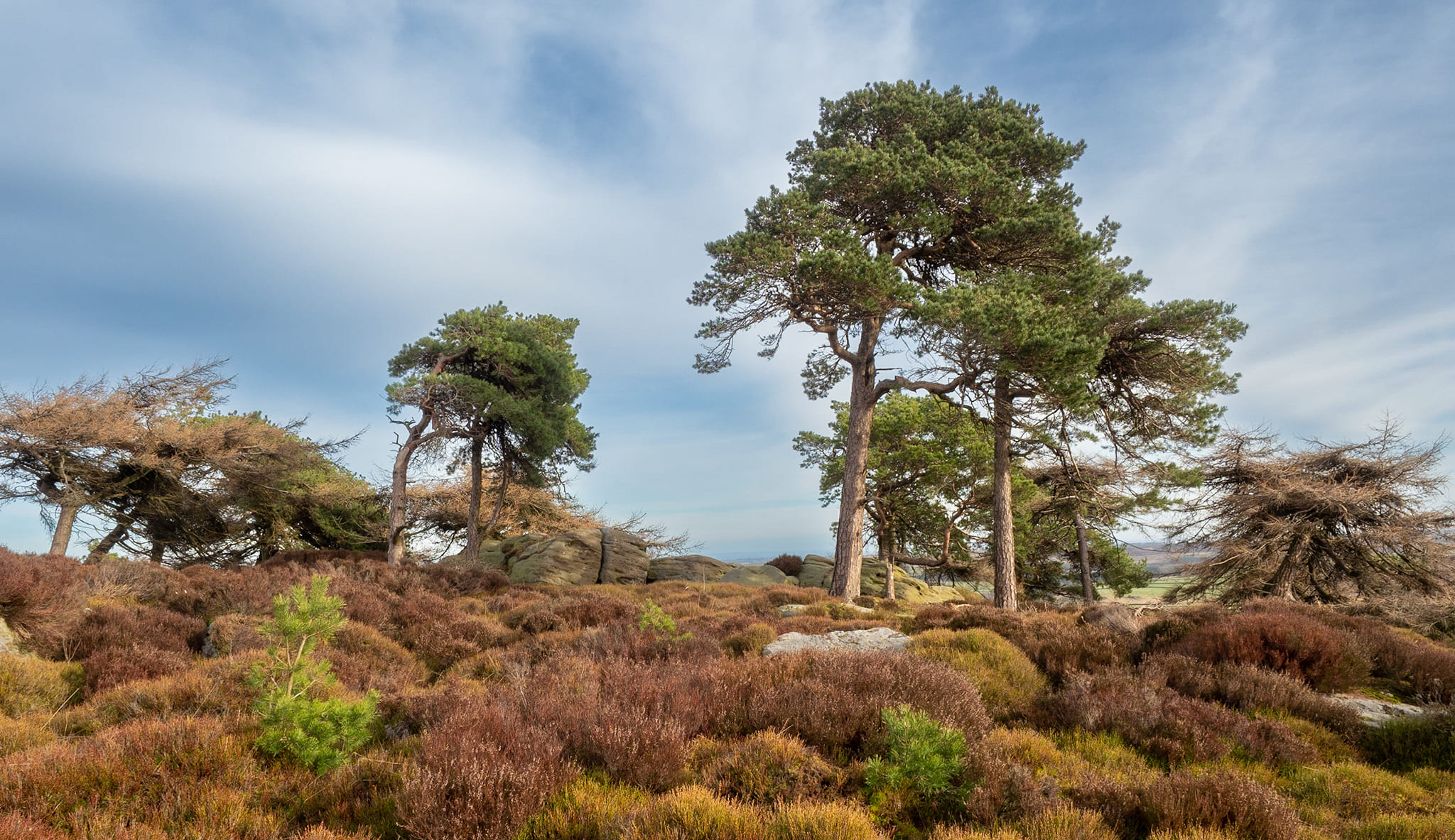
Take the A59 road from Harrogate and Skipton and at the very top of the moors keep your eyes peeled for the small Kex Ghyll Road on your left(it’s easy to miss, so be diligent!). It goes past some disused disused quarry and after a mile or so where you hit a junction, turn left, past the Outdoor Centre of West End and straight along Whit Moor Road. About a mile past the Outdoor Centre go left down to Brays Croft Farm and over the ford, then keeping to the footpath up to the right (west) and note the clump of trees on the moors above you to the west. That’s where you need to be.
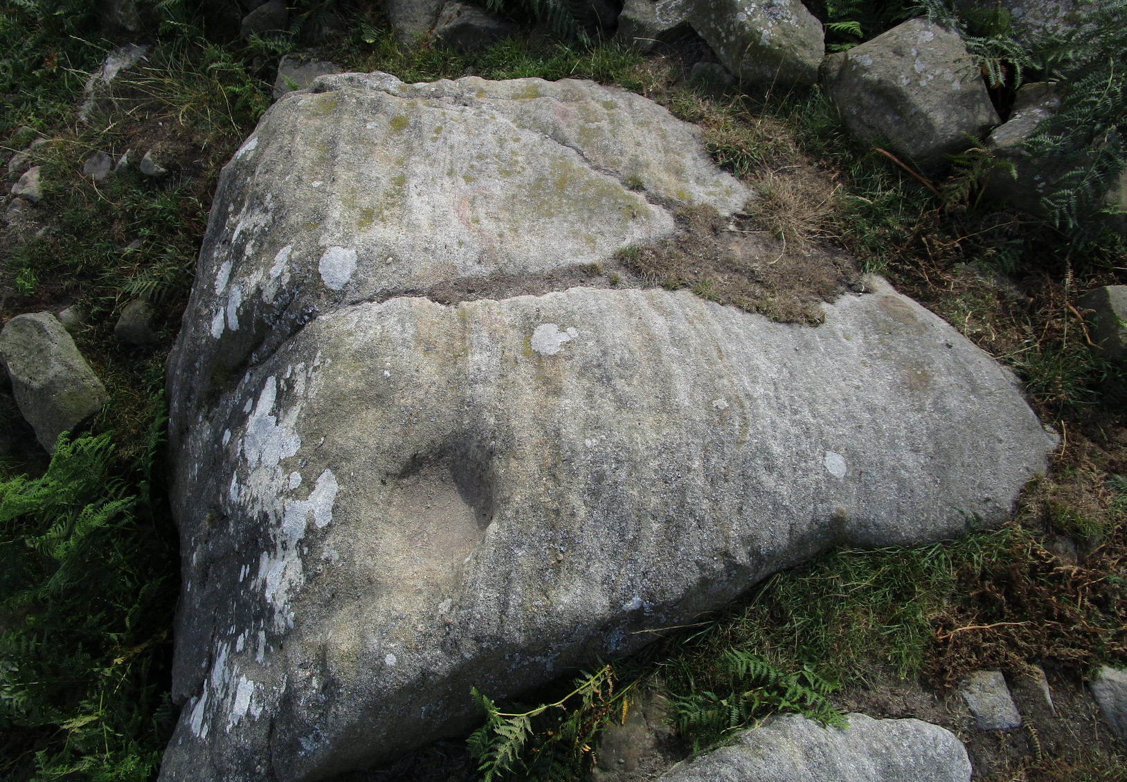
Archaeology & History
Several of the cupmarks
Several natural basins that might have been worked in prehistoric times are accompanied by several distinct cup-marks near the middle-edge of the stone, in a rough triangular formation, with two others slightly more eroded a little further down the same side. Boughey and Vickerman (2003) noted several other cupmarks on the rock, some distinct, some not so.
Adjacent to this carved stone is another naturally worn stone of some size, with incredibly curvaceous ripples over the top of the rock which, in all probability, possessed some animistic property to the people who carved this and other nearby carvings. Check the place out. It’s a gorgeous setting!
References:
Armstrong, Edward A., The Folklore of Birds, Collins: London 1958.
Boughey, Keith & Vickerman, E.A., Prehistoric Rock Art of the West Riding, WYAS: Wakefield 2003.
Round Barrows (destroyed): OS Grid Reference – NZ 692 214
Archaeology & History
Tumuli shown on 1920 map
On top of the large plateau that is Warsett Hill, on the southwest side of the old trig-point, could once be seen a cluster of at least seven burial mounds or tumuli. The mounds are shown on the first OS-map of the area, but merely as mounds. It wasn’t until there’d been a subsequent investigation here by local historian J.C. Atkinson in the 19th century that they were highlighted on the 1920 map as “Tumuli.” Sadly, since then, they’ve all been destroyed.
Very brief notes were written on six out of the seven tombs here by William Hornsby (1917), with only one of them receiving any real attention. “Of the other six,” Crawford (1980) wrote,
“there is very little information; all were excavated by Atkinson prior to 1893, but his excavations revealed no finds and he stated that all of the mounds had been previously disturbed. They were later dug by Hornsby, who stated that although he found no sepulchral deposits, all the mounds contained flints.”
In medieval times this became a beacon site, where bonfires were lit. I can find no further information about this. (NB: This site should not to be confused with another Warsett Hill that exists two miles southeast of here above Skinningrove.)
References:
Crawford, G.M., Bronze Age Burial Mounds in Cleveland, Cleveland County Council 1980.
Hornsby, William & Stanton, R., “British Barrows near Brotton,” in Yorkshire Archaeological Journal, volume 24, 1917.
Acknowledgements:Huge thanks for use of the Ordnance Survey map in this site profile, reproduced with the kind permission of the National Library of Scotland.
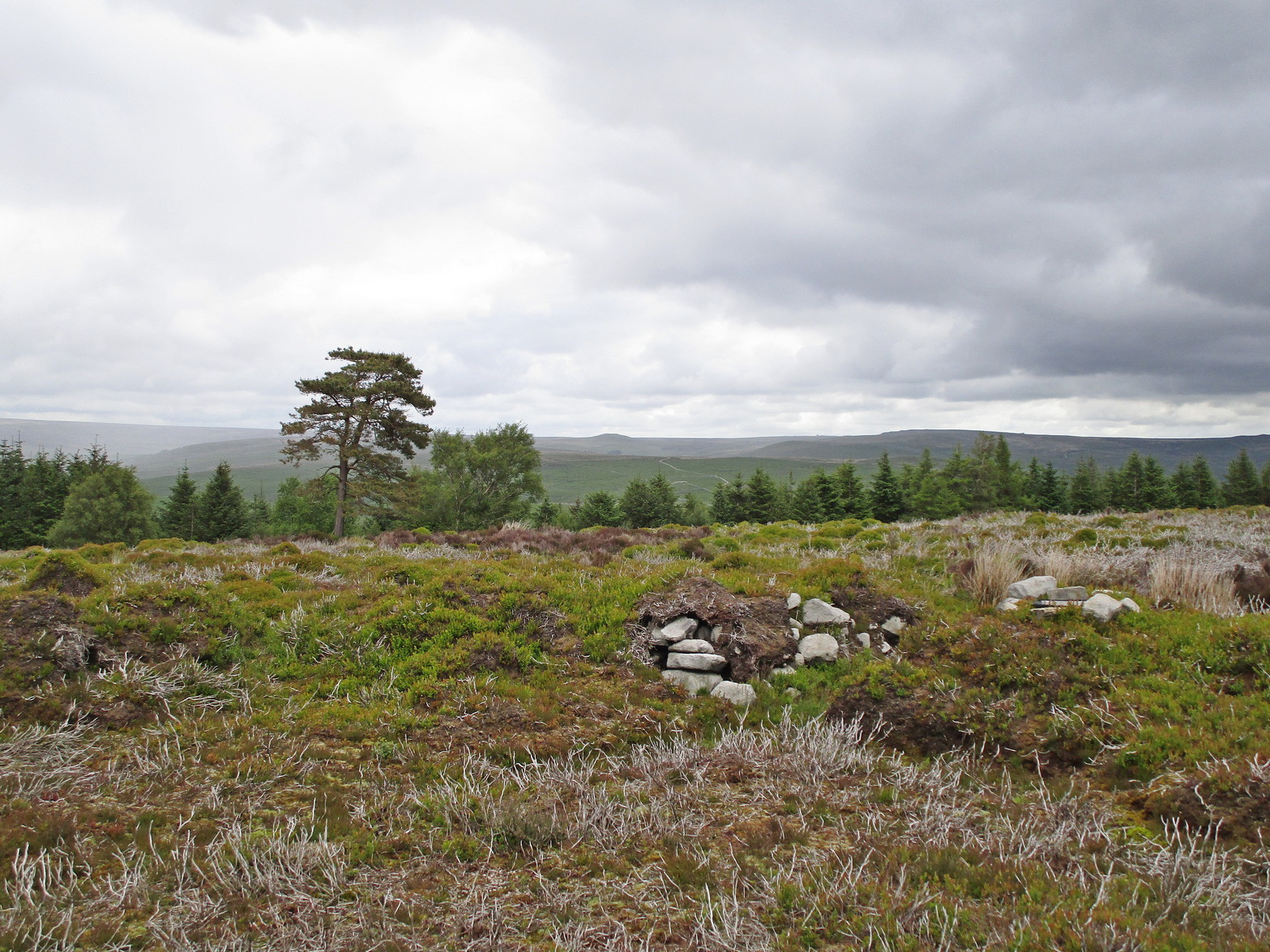
It’s easier to explain how to get here if you’re coming from the Burnsall-side of the B6160 road that leads to Bolton Abbey. A half-mile out of Burnsall village you a small woodland with a small parking spot. From here, a footpath runs up the steep hill above the parking spot. It zigzags a little and you eventually come out on the south-side of the trees where it meets some tall walling. Follow this walling further uphill for more than 600 yards (past more woodland) until the land starts to level out. Hereby, go thru an opening in the wall and less than 100 yards away (west) amidst the overgrown heather, you’ll see what you’re looking for.
Archaeology & History
A large but peculiar site resting on a moorland plateau on the eastern edges of the mighty Barden Moor. Peculiar inasmuch as it’s completely isolated from any other monument of the same age and type anywhere on these huge moors. A few miles east, on the moors around Appletreewick, Thruscross and Beamsley we have a plethora of prehistoric sites—but up here on Barden Moor there’s apparently nowt else! I find that hard to believe….
Inner rubble wallingRubble walling, looking N
Listed on official websites as being a ring cairn, it’s difficult without a detailed excavation of the site (there hasn’t been one) so say that’s what it is. But we’ll stick with it for the time being. My initial impression of the site was that it was a crude form of a collapsed Scottish dun: impressive large circular monuments—buildings if you like—with very well-built large stone walls, usually several yards thick, a little bit like the Scottish brochs (mighty things indeed!). This thing at Folly Top isn’t quite as impressive, but it’s like a collapsed version of a dun.
Arc of western walling
The site consists of large ring of raised collapsed rubble walling, more than a yard high in places, and about three yards thick all the way round, measuring roughly 21 yards (N-S) by 19 yards (E-W) from outer wall to outer wall. There are “entrances” on the east and west sides; but there seemed to be little of any note in the middle of the ring, although the site was somewhat overgrown on our visit here. Outside of the ring there was also nothing of any note. It’s a pretty isolated monument which seems to have more of an Iron Age look about it than the Bronze Age—but until there’s an excavation, we’ll not know for sure.
It’s well worth checking out—and from here, walk onto the huge moorland above you to the west….
Acknowledgements: Huge thanks to the Crazy-gang of Sarah, Helen and James for their awesome assistance on our venture up here. A damn good day indeed! Cheers doods.
Follow the directions to reach the Ancestors’ Stone and the Sunrise Stone; and there, roughly halfway between them, right by the edge of the old collapsed walling, you’ll see this rise of a stone with a large ‘bowl’ on top. That’s it!
Archaeology & History
Mixing Stone, looking E
Laid upon the same geological ridge as our Ancestors’ and Sunrise carvings, there are one, possibly two faint cup-marks visible on the low flat surface near the edge of this rock, barely visible unless the light’s right. But the important element here, perhaps regardless of the cup-marks, is the ‘bowl’ or rock basin on top of the stone. Internally, it’s smoothed equally on all sides and, due to being in-between the two impressive petroglyphs, may well have had a practical function to it. Bear with me on this one…
The Mixing Stone’s bowl
Stone ‘bowls’ or cavities—natural and otherwise—have been made use of in many cultures for simple functional purposes, such as grinding flour, herbal mixes, etc. We find such traditions in some of the bullauns of Ireland and Scotland; whereas in similar stone bowls known as cat troughs in nearby Haworth, milk was poured to appease the spirits of the land (this tradition was still being maintained in 2001!). Folklore and traditions of such rock basins spread far and wide beyond the UK: one of the German terms for rock basins is Opferkessel, meaning ‘sacrificial basin’ and suggests ritualistic usage by early societies. Elsewhere on Earth there are numerous accounts of the ritual use of petroglyphs in which indigenous peoples tell of their use of plant- or rock-based paints (in many cases red ochre) to decorate the carvings. And it’s this element that I’m interested in here.
Water-painted cupmarks
The Sunrise and Ancestors’ Stones 10-15 yards either side of this Mixing Stone are ideal candidates for such petroglyphic paintings using early ochre and other stone or plant-based agents. Such activities would always have been ritualised, either in honour of ancestors, genius loci, calendrical rites, or whatever the pertinent ingredient was at that place and time. I’m suggesting simply that the rock basin on the Mixing Stone was used for just such purposes. This is no spurious suggestion, but at the same time it’s important to recognise that my thoughts here represent merely an idea, nothing more—not a fact. Whilst we know full well that these carvings were imbued fundamentally with animistic properties—a simple ‘fact’—this functional idea is just that—an idea. Students and petroglyph-nuts need to understand this. And the faded cup-marks at its edge are perhaps merely incidental…. though I don’t buy that misself!
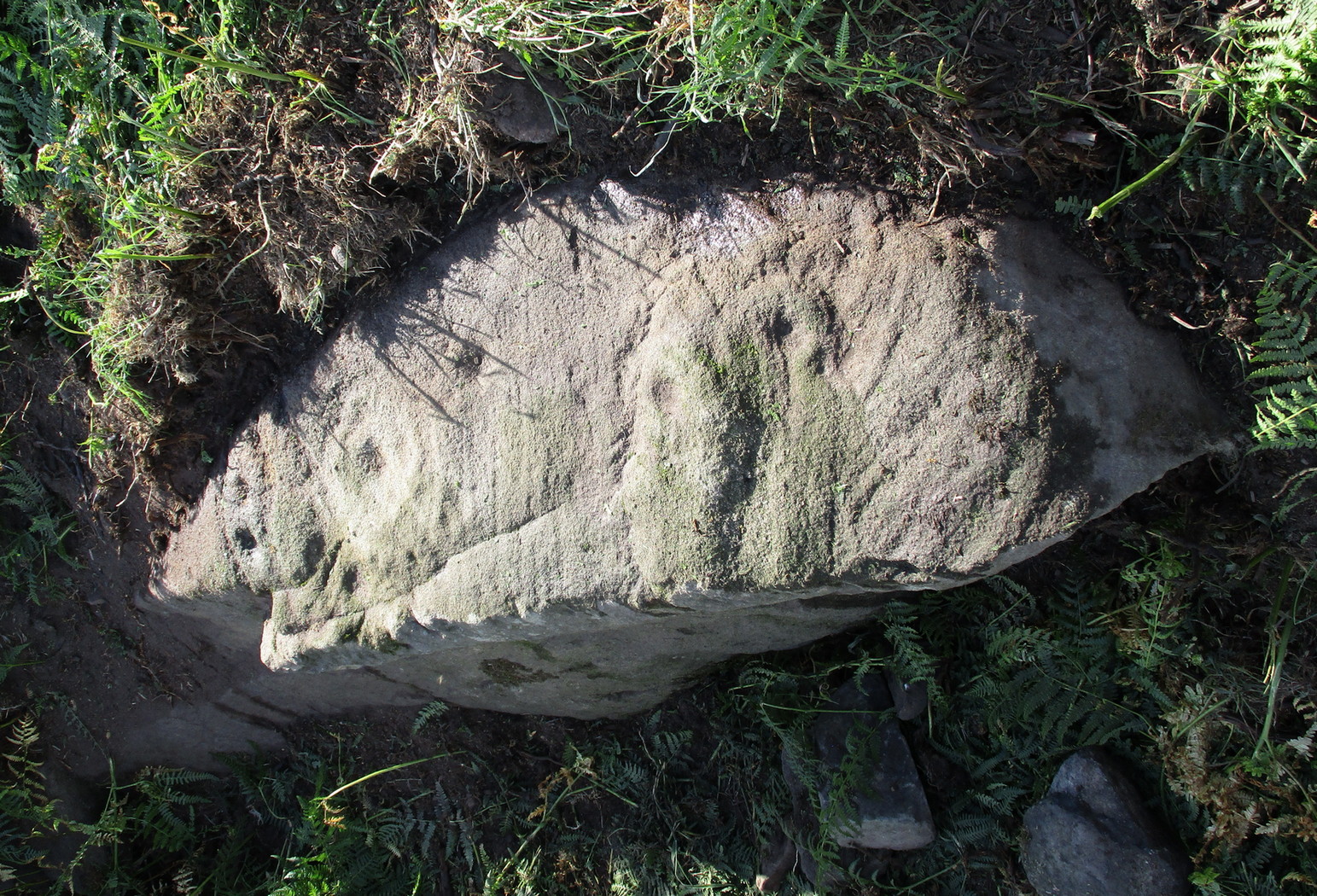
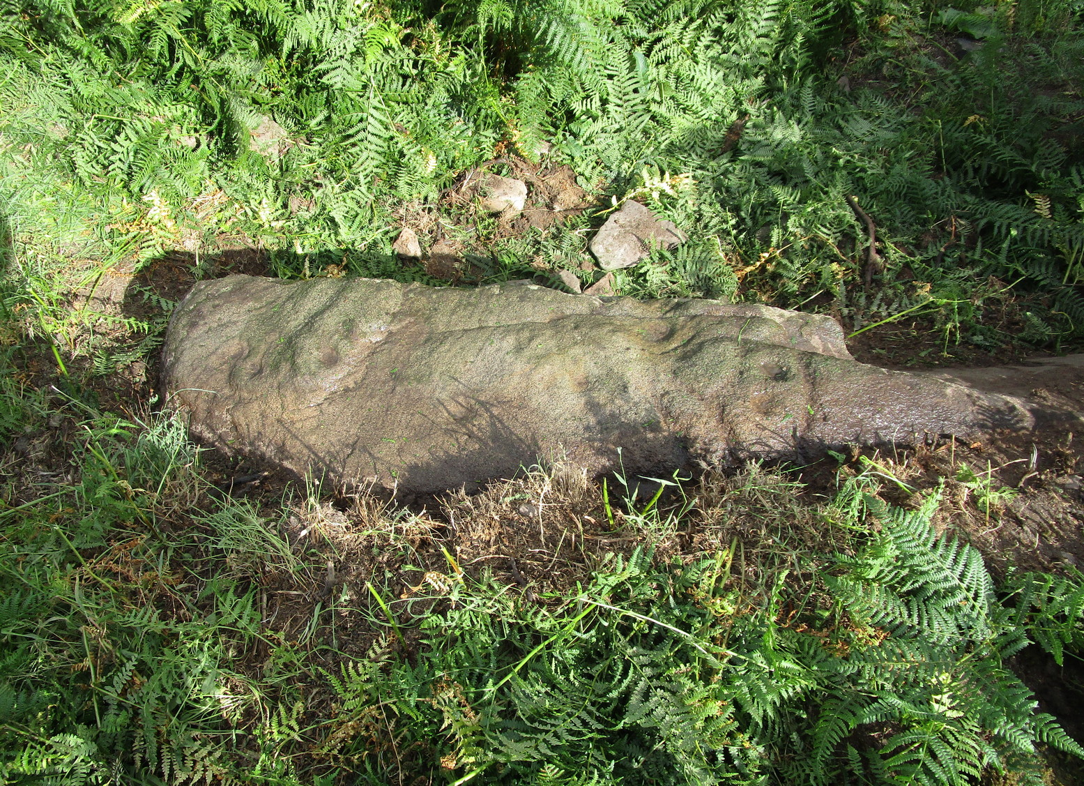
If you’re coming up from Otley or Askwith, take the same directions as if you’re going to visit the impressive Naked Jogger Carving (stone 612), not far from the well-known Tree of Life Stone. From the Naked Jogger carving, walk up to the small outcrop of rocks that bends above you. There’s a small collapsed line of walling just behind the outcrop. Walk along this up the slope as if you’re heading for the Sunrise Stone carving, but only 30 yards along, low down and right into the edge of the wall itself, you’ll see this elongated piece of stone. That’s the spot!
Archaeology & History
If you’ve caught the petroglyph-bug, you’ll like this one! It received its name from the curious fusion of natural cracks with the man-made pecked lines that shows, quite distinctly when the light is right and the stone is wet, the outline of two humanesque forms joined to each other. Figurative rock engravings of ancestors in the UK are extremely rare and when we came across this example, we noticed how the design could be interpreted as two Askwith Moor ancestor figures. Figurative rock art images elsewhere in the world such as the magnificent Wandjina paintings and the extensive galleries of figures engraved at Murujuga (Burrup Peninsula) in Western Australia, might provide an initial comparison, though more specific work needs to be done to better understand this unique petroglyph.
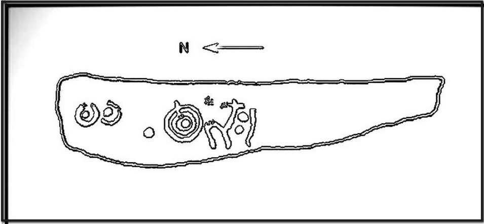
Sketch of the carving
You can almost make out the figures in the above photo: the upper torsos of two beings on the right-hand side of the rock, almost fused together. And the carved shapes of these “ancestral beings” are morphically similar to some elements in the Sunrise Stone just 50 yards away – which themselves remind me of a Northumbrian carving near Doddington known as West Horton 1a. (Beckensall 1991) But we should’t get too carried away by the idea because—as we can see here in the sketch of the carving—when looked at from a different angle above, we could infer the right-hand carved elements to be representative of an animal: a deer, perhaps. Rorscharch’s once more tickle the exploring mind….
The rock has been quarried into at same time in the past (just like the nearby Sunrise Stone), leaving us to wonder what the complete carving might have looked like. No doubt some pieces of it will be in the collapsed walling either side of the stone. All we have left to see are the two unfinished cup-and-rings above the natural cracks that give rise to the “ancestral being” appearance. The faint double cup-and-ring has curious linear arcs to its side, with two well-defined cups enclosed by two of them. It’s a nice-looking carving when the light is good. The petroglyph was carved over a long period of time, as evidenced by the differing levels of erosion in different sections of the design. It’s a common attribute. The oldest section is the faint double cup-and-ring, whose mythic nature was added to / developed at a much later date, perhaps even centuries later.
In the always-expressive archaeocentric description of Boughey & Vickerman’s (2003) otherwise valuable tome, they told this carving to be,
“Long, narrow, thick rock of medium grit. Six cups, one with a double ring with a tab out and two with at least partial single rings, grooves.”
Evocative stuff!
It’s very likely that this carving had some mythic relationship with its close neighbours either side of it, probably over a very long time period and I’m inclined to think it somehow related to the rising of the sun, just like its solar companion further up the slope. Please note how I emphasize this ingredient in the site profile of its neighbour, the Mixing Stone 10-15 yards away—roughly halfway between this and the Sunrise Stone. A distinct place of ritual was happening in this close-knit cluster of carvings…
References:
Beckensall, Stan, Prehistoric Rock Motifs of Northumberland – volume 1, 1991.
Boughey, Keith & Vickerman, E.A., Prehistoric Rock Art of the West Riding, WYAS: Leeds 2003.
Reeder, Phil, “Snowden Carr Rock Carvings,” in Northern Earth Mysteries, no.40, 1990.
The history of the site is scanty to say the least. It first seems to have been recorded when the Ordnance Survey lads came here in the 1840s, although they left no record as to why the site was given such a dedication. It’s a decidedly pre-christian title as the name “old Wife” is usually indicative in northern counties as being related to the primal Earth deity of northern England and lowland Scotland (when we reach the Highlands and Ireland, She becomes known—amongst other names—as the cailleach). However, apart from its name we have no additional information. Neither the holy wells writer Edna Whelan (1989; 2001), nor hydrolatry researcher Graeme Chappell were been able to find anything about the place in their own researches. And so we must go on name alone…
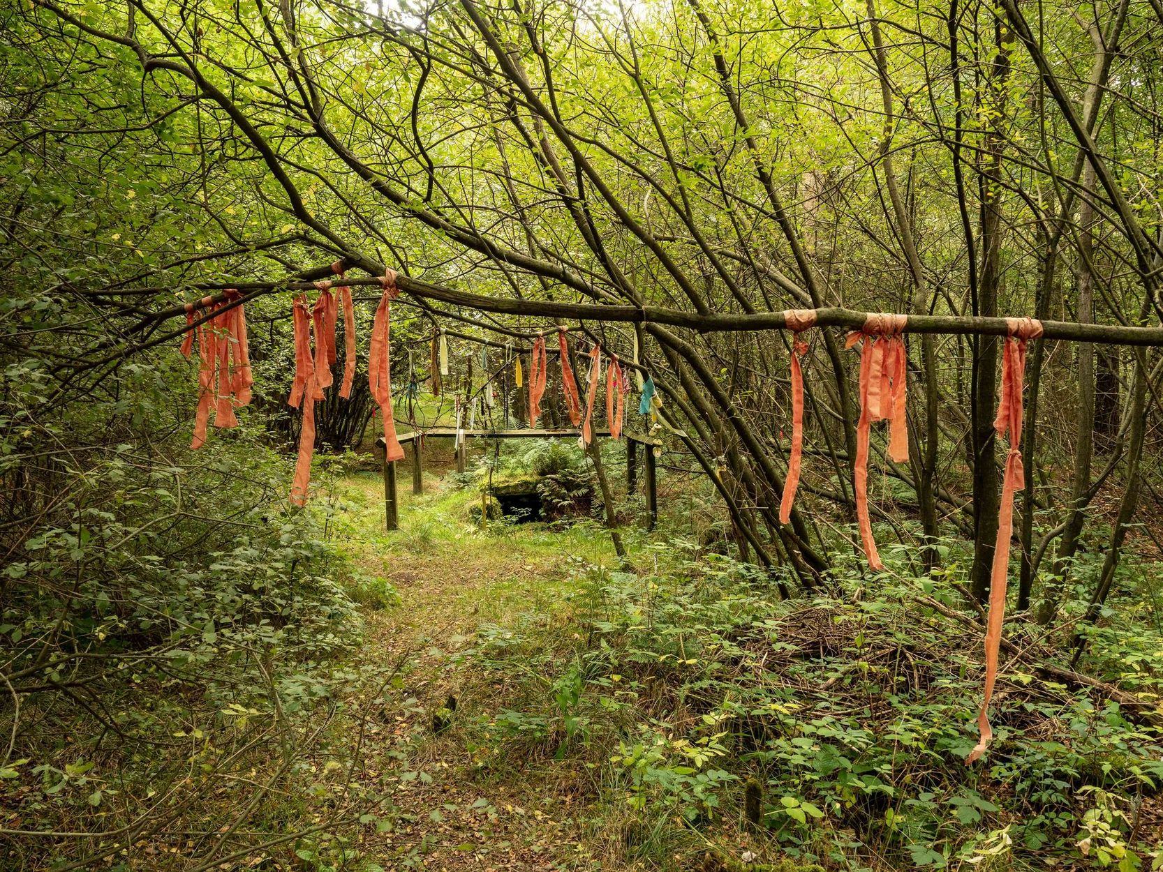
The waters bubble up into a small stone-lined chamber with the words Nattie Fontein carved into the lintel. This is something of a mystery in itself, for, as Edna Whelan (1989) told,
“it would be most unusual for the word fonten to be used for a spring in North Yorkshire: ‘keld’ is the local word. The rather roughly inscribed word may be a corruption of Fons Natalis, the name of a Celtic water nymph.”
Graeme Chappell (2000) meanwhile, noticed in a visit to the site in June 1999,
“that the N and A in “NATTIE” are carved in such a way that the word could be read as “MATTIE FONTEIN” perhaps meaning “Mother Fountain”. This might then be another reference to the Old Wife?”
He then goes on to note how,
“the latin word ‘natalis‘ meaning ‘birth’ and its link with the roman Festival ‘Dies Natalis Sol Invictus‘ (day of the birth of the unconquered sun) which took place on the 25th December. Natalis also gave rise to the welsh word ‘Nadolig‘ – meaning Christmas.”
This Yuletide element has an intriguing relationship with the name of the well; for to the west of Yorkshire’s borders into Cumbria there was annual gathering known as Old Wives’ Saturday that took place on the first Saturday after Christmas, or first Saturday of the New Year in a person’s house or inn, where a feast was had to bring in the New Year; but there is no known written lore of such a tradition here.
Nowadays the old tradition of hanging rags on the trees surrounding the well as offerings to the spirit of the place (known as memaws in parts of Yorkshire, and clooties in Scotland) has become a regular practice of those who hold such sites as sacred in their own way. Whelan mentioned seeing memaws here in the 1908s, but the Northern Antiquarian contributor Jon Barker told that, “The rags are a comparatively recent addition to the well, it is not a tradition there. When I used to go in the ’60s therewere no rags.”
On an even more curious note: very recently (from when this profile was written), the Northern Antiquarian contributor and photographer James Elkington visited Old Wives’ Well for the first time. It was a grey overcast day and when he arrived here, there was a woman ahead of him at the head of the well. I’ll let him tell the rest of it in his own words:
The Old Wives Well, Stape (James Elkington)Old Wives Well at Stape (James Elkington)
“In front of the well was a lady dressed in what looked like a white nighty, she had her back to me. There was a candle lit nearby, and her hands were in the water moving slowly about like she was washing something. She had long dark shoulder length hair. As I was about 25 feet away I was sure she wasn’t aware of me, and I thought it would make a good photograph. I quietly put my bag on the ground and got my camera out, and looked up and…she was gone! I couldn’t have taken my eye off her for more than 5 or 6 seconds. I looked all around and there was no sign of her. Even if she had legged it through the woods I would have seen her. I think it was then that I realized that I may have had ‘an encounter’. I quickly took three pics of the Well and got the hell out of there!”
He rang me once he had regained his senses in a somewhat emotional state and recounted over and over what had just happened. Whether this was a visual manifestation of the genius loci of the we can’t say. But such encounters are not unknown at numerous sacred water sites all over the world. We can only hazard a guess that this is what he was fortunate to encounter.
Just a few hundred yards north is the old Mauley or Malo Cross, which may or may not have had some mythic relationship with our Old Wives…