To search for any sites in the northern counties of England (previously known as Brigantia), click on the list of relevant counties, below. Please note that not all these english counties were truly in Brigantia, but they came close to its southern edges; and as parts of them tickle the edges of the southern Pennines, I thought they should be included. Hope that’s OK with everyone!
Walk about a mile along West Lane from Askwith village, towards Ilkley, until you reach a notable rounded bend in the road where, in the field immediately above you (behind the thorns) on your left, is a small scatter of large rocks at the edge of the field. One of these is what you’re after! (although this stone is just a couple of yards from the roadside, you can’t just pull up here and have a look — unless you’re an idiot! — without causing one hellova bad accident. So don’t do it!)
Archaeology & History
Carving no.509, Askwith
First described in Boughey & Vickerman’s (2003) survey, this is a curious “design” — if indeed that’s the right word! On the upper surface we can see, very clearly, one large cup and two deep curved lines set away from the cup-marking. One of these lines appears to curve along and down the edge of the rock and, on the shaded side below (somewhat overgrown with nettles when we were looking at it), what may be another large cup-mark and a continuation of the same “carved” line, roughly as drawn in the 2003 survey. It looks pretty good (if you’re a sad rock-art freak like me), but there could be another reason for the markings…
A mile upstream on the eastern edges of the wooded Scales Gill valley (known in previous centuries as both St. Helen’s Ghyll and the Fairy Dell), recent forestry and industrial work has scarred a number of rocks with engraved lines upon more faded cups or gunshot marks. When we wandered up here a few days ago and found a couple of these recently scarred stones, I remarked on how, in years to come, unless we made note of these very modern curves and grooves on the rocks, that future archaeologists will be cataloguing them as cup-and-ring stones. Several hours later on the way back home from our moorland wanderings, we ventured upon this, stone no.509.
I mention this for good reason: as a century back, only 100 yards away, are the remains of what was an old quarry that used industrial machinery similar to the ones that have made the recent curved markings on the stones a mile up the valley. And as we can see quite clearly with this stone and its companions, they’ve been moved and dumped into their present position at the field-side. We should keep this ingredient in mind when looking at this stone, just in case the archaeologists who’ve logged this as prehistoric have got their dates out by a few thousand years. With any luck however, I’ve got it all wrong…
References:
Boughey, Keith & Vickerman, E.A., Prehistoric Rock Art of the West Riding, WYAS 2003.
From the Askwith Moor car-park, walk down the road (south) for 2-300 yards until you reach the gate on the right-hand side of the road. Go thru this and turn immediately left, following the fence along, parallel to the road for about 100 yards (if you reach the small disused quarry, you’ve gone 100 yards too far), then walk into the heath, up near the top of the little peak and walk down the other side of the slope for about 80 yards. You’re getting damn close — look around!
Archaeology & History
First found on the afternoon of May 13, 2010, in the company of Dave Hazell — though at the time the light was poor and the sky was grey and overcast, not allowing for any decent images being made. We returned here yesterday under a lovely clear sky for most of the day (and without the polluting roars of planes from the nearby airport, thanks to that great Icelandic volcano [keep it going!], making it even better) and got some decent photos this time.
Sketch of basic designClose-up of some cups
It’s only a small low stone, slightly sloping (similar in size and form to carving no.535 about 100 yards west of here), and is gonna be very difficult to find when the heather is in full growth. But thankfully when we found it last week, the heather had been burnt back. Whilst there are two large and very notable cups here — one on the west-facing vertical edge of the stone, the other on its south-facing slope — several others are more troublesome to see clearly, both through a mixture of age and erosion. The other cups are a little smaller aswell, being very similar in status to the curious small cup-markings on the Lattice Stone carving (no.481). One cluster of these smaller cups are arranged in a curved T-shape formation around the middle to eastern-side of the rock. Below this are what seems to be a long singular cup, but upon feeling this — the Beckensall technique — the hardworking Keighley volunteer Michala Potts found it seemed to consist of three small cups all linked to each other. Attached to this section, a small groove runs up to the aforementioned T-formation cluster. Whilst at the top-end of the stone is what seems to be another larger cup-marking, but I’m not sure whether it’s Nature’s handiwork, or artificial. A few more visits here might enable us to say one way or the other!
There are no other archaeological remains immediately adjacent. Another “possible” cup-marked rock (more than twice the size of this stone) can be found about 30 yards further uphill, next to another large stone. But one of the nice things about this small carving is its position in the landscape: an excellent view opens up of mid-Wharfedale below you, and the uphills of Rombald’s Moor is on the far side of the valley. Make of it what you will…
References:
Boughey, Keith & Vickerman, E.A., Prehistoric Rock Art of the West Riding, WYAS 2003.
To get here, follow the same directions to reach the ornate Lunar Stone. Once here, walk about 20 yards west towards where the brow of the hill begins to slope down. Amble about and you’ll easily find it.
Archaeology & History
This is a fascinating carving. Fascinating, inasmuch as it seemingly keeps changing appearance when Nature moves her daylight hues and whimsical unpredictability betwixt the hills, surrounding landscape and human observer. Depending very much where you stand and when you look at this small rock — dappled with unacknowledged veils of sunlights, grey winds and other natural forces — determines what the stone shows you. This carving as much as any upon this hill shows once again the hugely neglected dynamic between human purveyor and Nature’s powerful subtlety: an organic exchange of moods from stone to man and back again; very much how our ancestors saw things to be…
Pecked lines clearly visible on the far end of the rockCarving from above
For if we were to merely pay attention to what the reference books tell us about this carving (good reference books though they are!), we’d simply be seeing a rock possessing a “cup and partial ring and two other possible cups”, as Boughey & Vickerman (2003) and other students might do. But then, if conditions change, only subtly, and we gaze instead of study, other things can emerge. And just such a thing happened when we came here yesterday…
On my first visit here I could only see a single cup-marking, with another ‘debatable’ close by. The light of day wasn’t quite right it seemed. But when we visited here yesterday, the sun, the light, the land and our ambling minds saw much more unveiled from this old grey surface. Whilst two cups-and-rings seem to link with another cup on the lower end of the stone, amidst the natural cracks and fissures, on the higher end are very distinct carved pecked lines, one of which has been blatantly cut onto, or upon, the long curving crack which runs from one end of the stone to the other. As this carved line emerges out of the natural crack, it heads upwards. As it does so, another line has been pecked running off it to the left and then curves back down the sloping rock-face once again. But in this previously unrecognised carved section, these lines may extend even further up the rock…..it’s hard to say for sure. We could do with greater analysis of its surface, with further observations under yet more lighting conditions.
References:
Boughey, Keith & Vickerman, E.A., Prehistoric Rock Art of the West Riding, WYAS 2003.
Hedges, John (ed.), The Carved Rocks on Rombalds Moor, WYMCC: Wakefield 1986.
Difficult to locate when the heather’s deep, but, from the Askwith Moor Road car-parking spot, walk up the road till you hit the fencing that cuts across Snowden Moor on your right. Follow the fence across the moor for about 300 yards where the moorland slope increases downhill. Go down here, keeping to the northern side of the fence and zigzag about. Good luck!
Archaeology & History
Cup-marked stone, Snowden Carr
On the hillside west of the Snowden Moor Settlement is this previously unrecorded cup-marked stone, discovered by Richard Stroud in May 2005. From the photo you get the impression there are perhaps 10 cup-markings etched onto the stone here, but looking at the site in the cold light of day, we both reckoned that perhaps just two or three of them were man-made. This is one of them carvings which has you scratching your head about the problems with some “carvings” and the difficulty one can sometimes have when it comes to answering the simple query about whether they’re natural or man-made.
It’s worth a look this one — not least because, when the conditions are right and the heather’s been burnt back, there’s one helluva decent prehistoric settlement very close by, giving you even more to puzzle over…
From the large parking spot by the roadside along Askwith Moor Road, walk up (north) 250 yards until you reach the gate with the path leading onto Askwith Moor. Follow this along, past the triangulation pillar until you reach the Warden’s Hut near the top of the ridge and overlooking the moors ahead. Naathen — look due south onto the moor and walk straight down the slope till the land levels out. If you’re lucky and the heather aint fully grown, you’ll see a cluster of stones about 500 yards away. That’s where you’re heading. If you end up reaching the Woman Stone carving, you’ve walked 100 yards past where you should be!
Archaeology & History
Discovered on the afternoon of May 13, 2010, amidst another exploratory ramble in the company of Dave Hazell. We were out looking for the Woman Stone carving and a few others on Askwith Moor, and hoping we might be lucky and come across another carving or two in our meanderings. We did find a previously unrecorded cup-marked stone (I’ll add that a bit later) — and a decent one at that! — but a new cairn-field was one helluva surprise. And in very good nick!
Cairn A, looking northwestCairn A, looking east
There are several cairns sitting just above the brow of the hill, looking into the western moors. Most of these are typical-looking single cairns, akin to those found on the moors above Ilkley, Bingley and Earby, being about 3 yards across and a couple of feet high amidst the peat and heather covering. But two of them here are notably different in structure and size (and please forgive my lengthy description of them here).
We found these tombs after noticing a large section of deep heather had been burnt back, and a large mass of rocks were made visible as a result. Past ventures onto these moors when seeking for cup-and-ring carvings hadn’t highlighted this cluster, so we thought it might be a good idea to check them out! As I approached them from the south from the Woman Stone carving (where we’d sat for a drink and some food, admiring the moors and being shouted at by a large gathering of geese who did not want us here), it became obvious, the closer I got, that something decidedly man-made was in evidence here.
Cairn A, looking south
Walking roughly northwards out of the heather and onto the burnt ground, a cairn-like feature (hereafter known as “Cairn A”) was right in front of me; though this seemed to have a ring of small stones — some earthfast, others placed there by people — surrounding the stone heap. And, as I walked around the edge of this large-ish cairn (about 9 yards in diameter and 2-3 feet tall), it was obvious that a couple of these outlying stones were stuck there by humans in bygone millenia. The most notable feature was the outlying northernmost upright: a small standing stone, coloured white and distinctly brighter than the common millstone grit rock from which this monument is primarily comprised. As I walked round it — adrenaline running and effing expletives emerging the more I saw — it became obvious that this outlying northern stone had long lines of thick quartz (or some crystalline vein) running across it, making it shine very brightly in the sunlight. Other brighter stones were around the edge of the cairn. It seemed obvious that this shining stone was of some importance to the folks who stuck it here. And this was confirmed when I ambled into another prehistoric tomb about 50 yards north, at “Cairn B.”
Cairn B, looking northCairn B, looking east
Cairn B was 11 yards in diameter, north-south, and 10 yards east-west. At its tallest height of only 2-3 feet, it was larger than cairn A. This reasonably well-preserved tomb had a very distinct outlying “wall” running around the edges of the stone heap, along the edge of the hillside and around onto the flat moorland. Here we found there were many more stones piled up in the centre of the tomb, but again, on its northern edge, was the tallest of the surrounding upright stones, white in colour (with perhaps a very worn cup-marking on top – but this is debatable…), erected here for some obviously important reason which remains, as yet, unknown to us. Although looking through the centre of the cairn and onto the white upright stone, aligning northwest on the distant skyline behind it, just peeping through a dip, seems to be the great rocky outcrop of Simon’s Seat and its companion the Lord’s Seat: very important ritual sites in pre-christian days in this part of the world. Near the centre of this cairn was another distinctly coloured rock, as you can see in the photo, almost yellow! Intriguing…
The smaller “Cairn C”
Within a hundred yards or so scattered on the same moorland plain we found other tombs: Cairns C, D, E, F, G and H — but cairns A and B were distinctly the most impressive. An outlying single cairn, C, typical of those found on Ilkley Moor, Bingley Moor, Bleara Moor, etc, was just five yards southwest of Cairn A, with a possible single cup-marked stone laying on the ground by its side.
Just to make sure that what we’d come across up here hadn’t already been catalogued, I contacted Gail Falkingham, Historic Environment team leader and North Yorkshire archaeological consultant, asking if they knew owt about these tombs. Gail helpfully passed on information relating to a couple of “clearance cairns” (as they’re called) — monument numbers MNY22161 and MNY 22162 — which are scattered at the bottom of the slope below here. We’d come across these on the same day and recognised them as 16th-19th century remains. The cairnfield on top of the slope is of a completely different character and from a much earlier historical period.
We know that human beings have been on these moors since mesolithic times from the excess of flints, blades and scrapers found here. Very near to these newly-discovered tombs, Mr Cowling (1946) told that:
“On the western slope of the highest part of Askwith Moor is a very interesting flaking site. For some time flints have been found in this area, but denudation revealed the working place about August, 1935. There were found some twenty finished tools of widely different varieties of flint. A large scraper of red flint is beautifully worked and has a fine glaze, as has a steep-edged side-blow scraper of brown flint. A small round scraper of dull grey flint has the appearance of newly-worked flint, and has been protected by being embedded in the peat…One blade of grey flint has been worked along both edges to for an oblong tool… The flint-worker on this site appears to have combed the neighbourhood to supplement the small supply of good flint.”
All around here we found extensive remains of other prehistoric remains: hut circles, walling, cup-and-ring stones, more cairns, even a probable prehistoric trackway. More recently on another Northern Antiquarian outing, we discovered another previously unrecognised cairnfield on Blubberhouse Moor, two miles northwest of here.
References:
Cowling, Eric T., Rombald’s Way: A Prehistory of Mid-Wharfedale, William Walker: Otley 1946.
Jack, Jim, “Ancient Burial Ground and Bronze Age Finds on Moor,” in Wharfedale Observer, Thursday, May 27, 2010.
From Shipley Glen, walk up to the Dobrudden caravan park on the western side pof Baildon Hill and then in the long grasses immediately north of here, on the Low Plain, this old carving could once be found. I’m told it’s been moved in recent years (but have a mooch round anyway – there’s a number of other old cup-and-rings in the locale).
Archaeology & History
This small carving is not in its original position, having been moved to where it now sits a short distance northeast of the Dobrudden caravan park. It was first described briefly in Mr Baildon’s magnum opus here, seemingly omitted from the Hedges (1986) and reclassified as ‘stone 169’ by Boughey & Vickerman (2003). I’m not 100% certain that the illustration here by Joseph Rycroft and carving no.169 are one and the same – but they seem incredibly alike. If anyone knows for sure, one way or the other, please lemme know and I’ll amend as necessary!
References:
Baildon, W. Paley, Baildon and the Baildons – part 7, Adelphi Press: London 1913.
Boughey, Keith & Vickerman, E.A., Prehistoric Rock Art of the West Riding, WYAS 2003.
Hedges, John (ed.), The Carved Rocks on Rombalds Moor, WYMCC: Wakefield 1986.
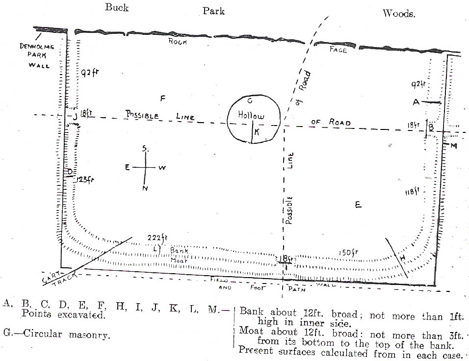
C.F. Forshaw (1908) told us that “this Castlestead…lies on the high ground between Cullingworth and Denholme, about 300 yards east of the point where te Cullingworth Road meets the Halifax-Keighley Road in Manywells Height, and over looks Buck Park Woods and the beck flowing down a deep ravine to enter the head of Hewenden Reservoir. A little to the north lies Moat Hill Farm…and the ancient burial place therewith associated.” Very little remains of the site can be seen.
Archaeology & History
C.F. Forshaw’s 1908 plan of this Castle Stead site
Just over a mile southeast of the site of (virtually) the same name — the Castlestead Ring — this here Castle Stead site had me thinking that both sites were one and the same (poor research on my behalf I’m afraid). At the moment, the archaeological period of when this site was constructed remains unknown. Thought by Forshaw (1908) to be “almost certainly a hitherto unknown Roman entrenchment,” the very slight remains left here could be Iron Age or Romano-British. In his lengthy article on the remains that could be seen here more than 100 years ago, Mr Forshaw told us:
“Several fields hereabouts bear the name Castlestead and one of these contains the entrenchment, which almost coincides within its area… The reason for the selection of this site is clear, for on no side is it commanded by higher ground: whilst one face has a natural fortification of a rock scar impassable at most points and easily accessible at none. Here very little art would make the position impregnable in primitive warfare, and it is noticeable that the most suitable part of the verge has been selected, and almost the whole of the scar has been included. It is, however, only right to state that stone has been quarried here within living memory and this may have altered the ground considerably, and may account for several features mentioned hereafter.
“The accompanying plan (above) will make the outline of the fortification clear, and from it one can readily recognise the usual Roman form. The moat and bank, the quadrangular shape with rounded corners and the entrances on three sides (and possibly on the fourth also) are characteristic. The unusual point is the selection of a natural fortification for one (the south) side.
“The question at once arises: was this a permanent stone fort? Clearly not, for the bank has been cut across at four places (A, D, H & L) and not only was no stone found — beyond such odds and ends as may be seen in any field — but the deeper, undisturbed layers of silt showed no signs of a trench in which foundations might have stood. It is noticeable that there are more stones on the crown of the bank than elsewhere. This I take to be the remains of what was thrown up in the bank. The field has been cultivated many years, so that the bank has been much reduced in height and the moat filled up.
“The original height of the bank is difficult to guess, but the moat was about three feet deeper than at present at the point H, and from the amount of soil removed we may imagine the bank about five feet higher than it is now, and solid at that; this makes a total outside slope of about 10 feet, a very formidable obstacle to surmount in the face of opposition, especially is strengthened by a stockade, such as was possibly present.The remains of the bank are capped with a layer of some six inches of bluish, silty clay. This was evidently placed there deliberately, and is in accordance with Roman work as seen elsewhere (e.g., at Castleshaw, near Oldham). There is also some slight evidence that, as at Castleshaw, the moat was once faced with irregular pieces of flat stone. The moat was some 18 feet across at the top, six feet at the bottom and five feet deep. The east and west sides were probably less strongly entrenched. Certainly the moat was much less, for rock lies only just below the sod, halfway along the western side. When the southern face is examined there are more signs of stonework, however, for where the rock is deficient the gap is filled with the remains of a dry wall which has some peculiar characteristics. In places the lower part of this wall is formed of roughly-shaped oblong blocks of large size (one has a face of 57 x 17 inches), arranged in definite tiers. This is not like an ordinary field fence, and differs even more from the ancient wall marked (probably erroneously) as Denholme Park Wall on the Ordnance map, which it continues: so it is conceivable that it may be Roman work. There is now little or no sign of a bank along the rocks bounding the southern side of the camp, but it is probable that something once existed to give cover to the defenders, and we may well imagine a low dry wall continuous with the fragments just described: and it is rather noticeable that there are more squared stones in the walls of this field than in others in the neighbourhood.
“There are no traces of buildings within the lines so far as the present investigations go, nor signs of prolonged occupation at the site. I have dug at the points indicated (on the map above) and came upon rock or disturbed silt in each case. The circular shallow hollow in the centre seems natural. It is to be remarked that the average depth of surface soil in this field is unusual, more than one foot in fact.”
Mr Forshaw then goes on to ask a series of questions, followed by his own particular answers and theory relating to the nature of these earthworks. Hopefully you won’t mind if I cite his ideas in full, despite him thinking that the remains here are of Roman origin (remains of which I don’t really wanna include on TNA). He continued:
“Was this camp on the course of a Roman road? One can only say that no definite road exists at the entrances now, but there seems some ground for thinking that a surface was prepared…at the western entrance for two reasons:
1. Just to the north the rock is covered with made soil only; but in the entrance itself irregular stones are packed in a level, solid manner, giving a strong impression of artificiality. At the southern verge of the entrance this layer ends abruptly in a line at right angles to the bank, and here it is based not on rock, but on natural silt.
2. A slight hollow runs straight westward from it for some twenty yards through the next field. This may represent a destroyed road.”
Mr Forshaw then makes a few attempts to justify this idea, including notices of footpaths and linear features near the site, aswell as citing earlier historical sources that describe Roman roads — but the ones cited are some considerable distance from this site. In summing up, he notes how no Roman finds were made here — nor indeed any finds from earlier periods — but he opted for the site being a temporary Roman outpost. The more recent opinions of this place are that it was of late Iron Age or Romano-British origin.
References:
Cudworth, William, Round about Bradford, Thomas Brear: Bradford 1876.
Forshaw, C.F., ‘Castlestead, near Cullingworth,’ in Yorkshire Notes and Queries – volume 4, H.C. Derwent: Bradford 1908.
Hindley, Reg, Oxenhope: The Making of a Pennine Community, Amadeus: Cleckheaton 2004.
James, John, The History and Topography of Bradford, Longmans: London 1876.
Keighley, J.J., ‘The Prehistoric Period,’ in Faull & Moorhouse’s, West Yorkshire: An Archaeological Survey to AD 1500 – volume 1, WYMCC: Wakefield 1981.
Varley, Raymond, “The Excavation of Castle Stead at Manywells Height, near Cullingworth, West Yorkshire,” in Transactions of the Hunter Archaeological Society, volume 19, 1997.
From Earby, go eastwards up the steep moorland Coolham Lane. A coupla hundred yards up past the little reservoirs on your right there’s a tall, large wooden stile to climb over, up the old heaps of quarried stone and onto the flat moorland plain of Bleara Moor. You’re here! If the heather’s grown back however, you’ve no chance of seeing ’em!
Archaeology & History
One of at least a dozen small cairns on NW of Bleara Moor
When we came up here the other day (ostensibly to check out the great Bleara Lowe tombs on top of the moor), a grey wet day scattered its more darkened light across the moor, which thankfully had been burnt back a few months previous. If this hadn’t happened, we’d have never seen what we found: a scattering of at least a dozen small single cairns, typical of those found on the upper and lower slopes of Green Crag Slack on Ilkley Moor. They’re on the lower northwest-facing plain of Bleara Moor and all are roughly the same size: about 3 yards by 3 yards across and only a foot or two in height, much overgrown in peat and vegetation. Although we found a good number of these small cairns where the heather had been burnt away, there also seemed to be others in the long heather itself, but this was, of course, hard to say with any certainty. A few more exploratory ventures in and around the moor would be good after the next heather-burning sessions!
From Heysham village centre by the little roundabout, go down the gorgeous olde-worlde Main Street for about 150 yards, keeping your eyes peeled for the little track up to the tree-lined church of St. Peter. Just before going up the path to the church, set back at the roadside, you’ll see an old pump in an arch in the walling. That’s St. Patrick’s Well!
St.Patrick’s Well, Heysham
Archaeology & History
Not to be confused with another St. Patrick’s Well a few miles north of here, little has been said of this old holy well in literary tomes (even Henry Taylor’s (1906) magnum opus missed it!) Sadly the waters here have long since been diverted (which violates religious tradition, quite frankly), and all we see today is an old iron water-pump set inside a stone arch, beneath which – I presume – the waters once ran. An old plaque on the site of this ancient well tells:
“This is one of two holy wells in Heysham village (the other, Sainty Well, is on private property and covered over), whose dedications are long since lost. Latterly the water from this well was used for utilitarian gardening purposes within the confines of the old rectory.
“Previously the well had fallen into disuse, suffered from surface contamination and became rubble-filled when the bank above gave way in the mid-1800s. In the early 1900s, the well-head was again rebuilt and the well itself was cleaned and made safe by capping with concrete. Recently (May 2002) the well-head has been refurbished and water artificially introduced, thus turning a derelict area into a feature of the village.”
It would be good if local people could complain to the regional water authority and make them redirect the waters beneath the well, back to the surface, to allow devotees — both Christian and otherwise — to partake of the holy blood sanctified by St. Patrick many centuries ago. And without fluoride or other unholy chemical compounds that desecrate our waters. Just the sacred waters of God’s Earth please!
Folklore
This is one of the many places in the British Isles where St. Patrick was said to have landed after he’d converted all the Irish into the christian cult! One of the traditions was that St. Patrick said the well would never run dry — which was shown to be untrue when the waters were filled in with rubble in the 19th century. The same saint also used the waters from the well to baptise and convert the peasants of his time.
References:
Quick, R.C., Morecambe and Heysham, Past and Present, Morecambe Times 1962.
From East Morton village, take the moorland road, east, and up the steep hill. Where the road levels out there’s a right turn, plus (more importantly!) a trackway on your left which leads onto the moor. Go up this track for a few hundred yards until you’re on the moor proper (by this I mean the track’s levelled out and you’re looking 360° all round you with all the moor in front of you). Just before the track starts a slight downhill slope, go into the heather on your right, for about 80 yards. You’re damn close!
Archaeology & History
I first came here many years back in my mid- to late-teens with an old school-friend Jon Tilleard, wandering about adventurously, occasionally stopping here and there when I found some stupid cup-mark or other seemingly innocuous scratch on the rocks, gerrin’ all excited and jumping about like a tit! But when we visited the place again a few days back my response was somewhat different. I was worse! But for good reason…
Primary features of CR-107Close-up of main features
The potential variations visible in this carving are peculiar, to say the least. Ones first impression shows a carving similar in many ways to that shown in Hedges (1986) fine survey; but upon closer inspection a number of initial visual responses begin to look murky. A seeming cup-with-double-ring aint what it seems! To me at least (sad fella that I am!), it’s far more intriguing and far less certain, with a number of oddities still left.
The central feature of the carving is the lovely near-cup-and-double-ring! As we can see in the photo here, there are some insecurities in the top-right of the outer ring. To the upper right of this is another cup-with-partial-ring that was not included in the Hedges (1986) survey, nor Boughey & Vickerman’s (2003) updated work. There are some obvious pecked carved lines — whose specific definition yet remains unclear — in and around this area of the petroglyph; but in the “official” illustration these elements or ingredients were somehow missed.
Eclipse Stone, looking west
When we visited the stone the other day, the naturally eroded lines on the rock seemed pretty obvious; but the more we looked, the less secure we were about some of them. Thankfully the light kept changing about, allowing us to get different perspectives — and with the low sunlight of evening casting itself across the rock, some additional features seemed obvious. In particular, what seemed like two natural “scratches” on the stone turned out to have been pecked and carved and the straight lines ran into the double cup-and-ring on the left-side. One of these — the lower and shorter of the two — seems to run into the central cup, but this aint certain. The longer top line has an even more circuitous venture: entering the outer ring, it passes onto the top-inner ring and then bends along its edge, before exiting again on the right-hand side, through the outer ring and heading out towards the large natural eroded cutting a few feet away (see my crappy drawing to get an idea). Other faint aspects on this stone may have the hand of man behind them…
My shit sketch!Hedges 1986 sketch
There are certainly a few other cups on the stone: one with a near semi-circle on its lower and right-hand side. The long nature-worn cut, right-of-middle, may have had the hand of man cutting into the cup at the bottom; and another couple of “is it? — isn’t it?” enhanced natural cups seem possible on the left side of the rock. There is also what looks like a distinct single cup-marking on the west-facing vertical face of the stone (you walk towards it from the track). It looks pretty decent, but I’ll let them there “professionals” assess the validity or otherwise of that one! But the other unmistakable and very curious ingredient is the deep, worn arc beneath the primary double-ring feature. This is, as the photo shows, separated by a long natural crack running halfway down and along the stone, above which possibly the double-ring feature touches. This large ‘arc’ feature gives the distinct impression of being a big smile! However…
Turn the image of the central feature upside down and you get a very different effect indeed. A rainbow above the surface of the Earth, with (perhaps) a pool in which the sun has reflected? Or an underworld venture? Looking at it from a few angles gives the impression of a comet moving across the sky, aswell as an eclipse with the diamond-ring effect. But as with cup-and-ring in general, there are plenty of other potentials! Which also begs the question: was it to be looked from the top or bottom (or left or right for that matter)?
I could waffle about this particular carving for much longer, showing that it had quite an effect on me. Check it out and sit with it for a while… It’s superb!
References:
Boughey, Keith & Vickerman, E.A., Prehistoric Rock Art of the West Riding, WYAS 2003.
Hedges, John (ed.), The Carved Rocks on Rombalds Moor, WYMCC: Wakefield 1986.