Cliff House, Amble, Northumberland

Cist (destroyed):  OS Grid Reference – NU 2730 0486

Archaeology & History

Site location on 1926 map

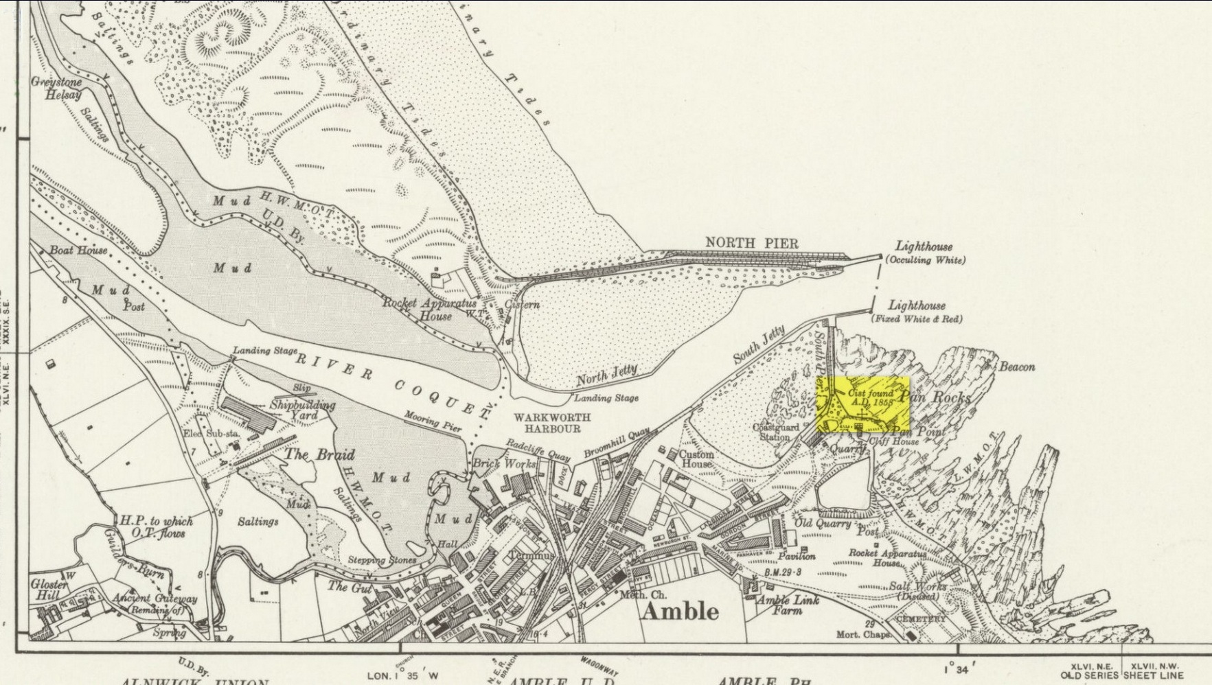
In November 1857, Collingwood Bruce read out a paper that had been sent to him by the Rector of Warkworth village (Rev. W. Dunn), describing “ancient sepulchral remains” that had been found near the cliff-edge above Pan Rocks near Amble’s lighthouse.  It was a lengthy account which, in passing, also mentioned several other prehistoric sites close by that have long since been destroyed and which we have very little information about.  Mr Dunn’s (1857) letter told:

“In the middle of April last, about 50 yards NE of the Cliff House, Amble, and about 20 yards from the end of what is called Warkworth South Pier, the pilots came upon a long upright stone, standing out of the shale to the height of twelve or fourteen inches,which had been laid bare by the recent heavy gales, but which, from its rude appearance, did not afford the idea of anything beyond a mere accidental tilting.  Alongside this upright stone was a large unwrought slab, which, on being raised, was found to be the covering of a cist or sepulchral chamber containing a perfect skeleton. The figure was lying on its left side, with the head to the south-west, having the knees much doubled and with the right arm thrown back.  By its side stood an urn of unbaked clay.  This urn, now in the Museum of the Duke of Northumber­land, resembles in size and shape that which was found a few years since at Hawkhill, and which is preserved in the Museum of the Antiquarian Society of Newcastle.  It contained a small quantity of dark earth.

“Having given this general outline of the discovery, I shall proceed to offer such observations as I have been able to make,and have considered worth recording. I grieve to say that before the period of my visit the spoiler had been busy with these venerable remains. The skull had been broken up, the jaws smashed, every tooth appropriated, and the bones indiscriminately mingled, after many a century of undisturbed repose.

“The cist or chamber containing the remains was composed of four slabs inserted edge-wise in a cavity which appeared to have been dug out of the friable shale which lies upon the harder rock in this locality. It ranged south-east and north-west, and measured as follows: depth, 18½ inches; width, 26 inches; length at bottom, 4 feet; at top, 3 ft 4 in.; the difference between top and bottom measurements being accounted for by the shrinking of the ends.  The cavity in the shale was much larger than the cist, and the space between the slabs and the shale was closely filled-in with stones, roughly broken, commingled with earth and larger stones.  The side slabs projected somewhat beyond the ends.  The bottom of the cist was covered to the depth of about half an inch, with dark, unctuous mould.  Amongst the rubbish comprising the filling-up of the space above-mentioned, was found an angular piece of silex, probably an unfinished arrow­head; and in the south-west corner of the cist lay a large, smooth cobble stone, which, when considered in conjunction with the flint flake, the imagination may easily construe into the club of this ancient denizen of our shores.  The slab which constituted the cover of the cist was of great size and extended in every direc­tion considerably beyond it; and the upright stone was set up, not at one of the ends, but along its length.  It is remarkable that a close inspection of these stones gave no trace of chisel-marks in any part.  In order that the cover might lie level, pieces of shale, flags, etc., were laid on the uprights which formed the cist, wherever an irregularity presented itself.

“Within the memory of man, the rock ran out from this point for some yards into the sea at a considerable elevation; but the construction of a pier in the immediate neighbourhood has caused the removal of much of the stone, and the spray of our wild sea waves now dashes over the spot which for countless generations may have been peacefully tenanted by these nameless bones.  At the same time, it does not appear probable that at any period there has been at this particular point a very deep covering of the sand and bent-grass which are found thick and rank upon the adjacent links.

“The skull must have been very characteristic, having attracted general observation from the extraordinary lowness of the frontal region, the great development of the occipital portion of the head, and the width and length of the lower jaw from its anterior junction to the articulation of the temporal bone.  One person observed that during life the man “must have measured as much to the top of his eyebrows as to the top of his head.”  The teeth are said to have been very beautiful and regular, and quite sound.  With the exception of a front tooth, which was missing in the lower jaw, they were perfect.  The thigh-bone measured 19½ inches, indicating a man of large size; whilst the porous internal organization of the bones gave probable evidence of comparative youth.

“The urn is unbaked, of a light clay colour, and measures in height 8 inches, in depth 7¼ inches, and in diameter 5½ inches.  It is ornamented with zigzag scoring, alternating with dotted lines,and upright (and sometimes slanting) scorings, which appear to have been made with some rude instrument whilst the clay was moist.  The scorings are continued over the edge of the rim.  On being rather roughly seized by one of the men, it being expected that it contained treasure, a piece was broken off; but no material injury has been occasioned.  The stone found in the cist does not resemble any that one may pick up on the neighbouring shore, and attracted attention from its bearing no assignable relation to what I may call the masonry of the tomb.  I have since learnt that stones are not infrequently found in Teutonic graves on the Continent, and that recently a singular oval stone was found in a tumulus on Petersfield Heath.”

All trace of this site has disappeared.  Mr Bruce posited the idea that the round stone in the cist may have been the one that ended the life of the buried man!  An intriguing thought.  And that the urn “no doubt, contained some portion of the feast prepared on the occasion of his funeral.”

References:

  1. Dunn, W., “Ancient Sepulchral Remains,” in Proceedings Society of Antiquaries Newcastle-upon-Tyne, volume 1, no.34, 1857.

© Paul BennettThe Northern Antiquarian

The map could not be loaded. Please contact the site owner.

Ryton (3), County Durham

Cup-Marked Stone (removed):  OS Grid Reference – NZ 1480 6417

Archaeology & History

Ryton cup-marked stone

In a short piece read before Newcastle’s Society of Antiquaries in 1942, a Mr Cocks (don’t laugh!) told that when a friend of his was clearing out an old land drain in his garden, he found this fragmented cup-marked stone, “which had been made use of as a corner slab on the drain”!  It was located “about 40 yards south-west of Tweedy’s Buildings,” on the west side of town.  Broken from a larger piece of stone, the attached photo here shows the simple design of the basic cup-marks, measuring respectively 2½, 2 and 1⅝ inches across.  Mr Cocks told that “there are also two finger-tip hollows on the stone tone which or may not be natural.  A dark line running between the cups is a natural fissure.”

Last we heard, the stone was living in a box somewhere in the archives at the Great North Museum, Newcastle.

References:

  1. Cocks, W.A., “A Cup-Marked Stone at Ryton,” in Proceedings Society of Antiquaries Newcastle-upon-Tyne, volume X, no.2, January 1943.

© Paul BennettThe Northern Antiquarian

The map could not be loaded. Please contact the site owner.

Tree Root Well, Liversedge, West Yorkshire

Healing Well:  OS Grid Reference – SE 19898 23679

Archaeology & History

Tree Root Well, 1908 map

Along with the nearby Attack Well and Balk Well, this was one of three water supplies for the people of Middle Gate between Hightown and Liversdge in the 19th century.  Found near the bottom of the old track known as Tanhouse Lane, its waters emerged at the base of some Victorian walling that’s built into the hillside, above which are the decayed remains of what seems to be an old hawthorn tree, whose roots obviously reached down to the stone trough, giving the place its name.  Its waters have long since dried up and fallen back to Earth.  Although it is shown on the 1908 OS-map of the region, I can find no virtues ascribed to the well nor any local history notes.

Acknowledgements: Huge thanks to the great Gary Ferner, for help in locating the site and the day’s venture!

© Paul BennettThe Northern Antiquarian

The map could not be loaded. Please contact the site owner.

Gab Wood (1), Cookridge, Leeds, West Yorkshire

Cup-and-Ring Stone:  OS Grid Reference – SE 24610 40721

Getting Here

Gab Wood (1) stone

On the north side of Cookridge, find Smithy Lane and go to the western-end, where it meets up with a dirt-track.  Walk straight along here by the side of the cricket-pitch and then take the first turn left where you walk along the other edge of the cricket pitch.  About 150 yards along, the track hits the woods; keep along here for about another 200 yards where you’ll find a small footpath on your left goes into the woods. Once you’re in in the trees, walk to your right, following the wall, for about 50 yards where you’ll see a large flat stone by the holly trees.  That’s it!

Archaeology & History

Rediscovered by the Leeds historian Don Cole in the 1940s, this complex multi-period carving etched onto a flattened rock surface is an unusual outlier from the Rombalds Moor complex several miles to the west.  At its heart, around the semi-natural deep “cups” near the middle of the southern side of the stone, is the oldest part of the carving comprising a very faint incomplete triple-ring design which, as we move around it, almost has the look of a Newgrange-lozenge form to it.  But I’m unsure…

Very faint incomplete triple-ring at top-middle
Waves & cups and rings

More obvious (apart from the deep “cups”), and the first thing you notice as you approach the stone, are the later and much more well-defined elements on the east side of the stone: a curious wave-form writhes from the edge of the rock across its smooth surface, beneath which we find a cup-and-ring and a number of single cup-marks, some enclosed inside a rounded box, with others sat between the curved carved line and the stone’s edge.  The “rounded box” with its three cups at first seems to be on its own, but as the light changes you’ll notice a much fainter (possibly older) rectangular box attached to it; no cups are visible inside this.

A hundred yards due south in the same woodland you’ll find the Gab Woods (2) carving.

One interesting feature is the name of the woodland in which the stone resides.  In Thomas Wright’s massive dialect work, Gab is a northern dialect word meaning “to talk”, or “idle chatter” (and variants thereof); this is echoed in Blakeborough’s (1911) Yorkshire survey; and Wilkinson’s (1924) local study tells simply it to be “idle talk…able to talk glibly and with much plausibility—a Town Hall Square orator for instance.” This makes the place as something akin to being “the woodland that talks”, “the chattering woods” or “the talking woodland”, etc.  You can make up your own mind as to what this might mean… *

References:

    1. Blakeborough, Richard, Wit, Character, Folklore and Customs of the North Riding of Yorkshire, W. Rapp: Saltburn 1911.
    2. Wilkinson, John H., Leeds Dialect Glossary and Lore, privately published: Leeds 1924.
    3. Wright, Joseph, English Dialect Dictionary – volume 2, Henry Frowde: London 1900.

Acknowledgements:  Huge thanks must go to Peter Murphy for recovering this impressive carving from beneath the carpet of soil and vegetation, and so enabling it to be seen by others once more. Also big thanks to the usual culprit of James Elkington, as well as Sarah Walker and Sarah Jackson.

* a Scottish dialect variant of gab relates to the mouth, tongue, taste.

© Paul BennettThe Northern Antiquarian

The map could not be loaded. Please contact the site owner.

St. Giles’ Well, Lightcliffe, West Yorkshire

Holy Well (lost):  OS Grid Reference – SE 134 245

Archaeology & History

Giles’ House to centre

In times gone by there was a singular St.Giles’ Well in the old village of Lightcliffe, but the only reference we have of it is from one of James Parker’s works (1904) where, in his description of St. Giles’ House, he tells, “It derives its name from an ancient well, called ‘St. Giles’ Well,’ which once existed near to the house, and was dedicated to St. Giles”: an 8th century Greek prince who left everything to become a hermit. He lived on wild herbs and developed the ability to cure rheumatism (perhaps a curative aspect of the well), cripples and help beggars. He is the patron saint of woodlands and his symbol is the arrow gained after he healed a wounded doe shot by one (the mass of Robin Hood folklore in this area may have something to do with this symbolism).  His date is September 1.

A.H. Smith (1963) cites the “local tradition that it is named from a well dedicated to St. Giles,” but thinks this attribution to be an unlikely one.  As can be seen on the accompanying map, a great number of wells are in this area, none of them named, with one just below the said Giles House.

References:

  1. Parker, James, Illustrated History from Hipperholme to Tong, Percy Lund: Bradford 1904.
  2. Smith, A.H., The Place-Names of the West Riding of Yorkshire – volume 3, Cambridge University Press 1961.

Acknowledgements:  Huge thanks for use of the Ordnance Survey map in this site profile, reproduced with the kind permission of the National Library of Scotland

© Paul BennettThe Northern Antiquarian

The map could not be loaded. Please contact the site owner.

Holy Moor, Holymoorside, Derbyshire

Cup-and-Ring Stone:  OS Grid Reference – SK 3211 6866

Getting Here

The stone in question!

From Holymoorside, take the long straight Loads Road running west out of the town into Longside Road. ¾-mile along, past Home View and just before Well Lane (on the right), there’s a public footpath sign pointing into the fields on your left. Walk dead straight, dead south along the wallside for 450 yards, then walk straight left again along the other wall until you reach the tiny bit of moorland less than 150 yards away.  The carved rock is just on the other side of the stile at the edge of the old walling.  You’ll find it.

Archaeology & History

Rediscovered sometime in 2002, this would seem to be an isolated cup-and-ring stone.  It was first mentioned in John Barnatt’s (2003) short gazetteer of Peakland petroglyphs, where he wrote,

“This irregularly-shaped small boulder was identified recently lying amongst post-medieval field clearance adjacent to a field corner and footpath… Its upper parts ar covered with 40-46 cupmarks.  On the exposed irregular top they are badly worn and sometimes uncertainly identified.  In one instance a cup is partly encircled by a worn ring, while a second partial ring nearby may be fortuituous.  On a ledge near one edge of the boulder preservation is better and the cups are clearly defined and densely arranged.”

The stone looks as if it’s been moved into its present location, obviously for use in the walling.  It’s original position would have been somewhere close by, but we know not where that might be.

References:

  1. Barnatt, John & Robinson, F., “Prehistoric Rock Art in Ashover School and Further New Discoveries Elsewhere in the Peak District,” in Derbyshire Archaeological Journal, 123, 2003.

Links:

  1. Pecsaetan – Holymoorside Cup-and-Ring Marked Boulder 

Acknowledgements:  Huge thanks to Geoff Watson for use of the photos in this site profile.  It wouldn’t have been written without them.

© Paul BennettThe Northern Antiquarian

The map could not be loaded. Please contact the site owner.

Reva Hill (1), Hawksworth, West Yorkshire

Cup-Marked Stone:  OS Grid Reference – SE 15230 43179

Getting Here

Main cups numbered

Numerous ways to get here, it’s probably the easiest (direction wise) to reach here starting from Dick Hudson’s public house on the southern road surrounding Rombalds Moor. From the pub, head left (east) along Otley Road (passing Weecher reservoir) for 1.9 miles (3.1km) until you reach Reva reservoir where a track leads you to the waters. A small parking spot is on the left-side of the road. From here, go through the gate and up the footpath (north) for about 200 yards then turn right and go up the field towards the wall where, about 20 yards before it, you’ll see find the stone in question.

Archaeology & History

This long earthfast stone has two distinct cup-markings: one near its northern upper end, and the other near the lower southern end, as highlighted on the above photo. (forgive the poor image, but we took it when the sun was pretty high in the sky)  It seems as if there are two or three other very faint cup-marks on the upper end of the stone, close to the most distinct one, but none of our photos show them with any clarity.

Acknowledgements:  Huge thanks to Sarah Walker and Thomas Cleland for help with location and imagery for this stone.

© Paul BennettThe Northern Antiquarian

The map could not be loaded. Please contact the site owner.

Meg Dyke, Barkisland, West Yorkshire

Enclosure / Settlement:  OS Grid Reference – SE 0496 1747

Getting Here

Meg Dyke earthworks

If you’re coming via Ripponden, take the B6113 road uphill to Barkisland; but if from the Huddersfield direction, take the B6114 to Barkisland.  Once in the village, stick to the B6114 Saddleworth road going south.  After passing the unmissable Ringstone Edge reservoir (the Ringstone circle is on its far side) the Saddleworth road begins to straighten out and you hit the large quarry on your right.  But before the quarry entrance, keep your eyes peeled on your left for the minor Scammonden Road that slopes downhill.  50 yards down, a gate and stile allows you into the field on your left (north) where you’ll see the scruff of earthworks.  Y’ can’t really miss it

Archaeology & History

Watson’s 1775 plan

On the face of things, this is nowt much to look at unless you’re a prehistoric settlement freak!  It is however a very notable rectangular set of ditches and embankments, with the ditches averaging between 10-12 feet across and 3-4 feet deep in places; whilst the raised banks vary between 13-20 feet across.  The place was quarried into sometime at the end of the 19th century, casusing obvious damage, but its outer ramparts are still plain to see.  It’s been known about for quite a few centuries too.  Even before the Ordnance Survey lads had stuck it onto their brilliant mapping system, the great John Watson (1775) described these old ruins as,

“a piece of ground inclosed within deep ditches, on the side of the hill called Pikelow, one of which, to the west, is fifty-three yards long, full five yards wide, and about two yards deep; the opposite side to this cut by a wall and a road, but is very visible in the adjoining field, the plough not having yet been able to destroy it. The ditch to the south measures also fifty-three yards, but it is not so entire as the other. There is an opening at each corner of the western ditch which, if continued, would make the whole to be ninety-six (sic) yards each way. One of the sides towards the east is nearly levelled, the rest is in good preservation.”

Meg Dyke on 1854 OS-map
Petch’s 1933 photo

He thought the remains to be Roman—a sentiment echoed by local archaeologist James Petch in 1924.  More recently however, following a small excavation at the site by the Huddersfield Archaeology Group, Faull & Moorhouse (1981) suggested it to be Iron Age in nature—though with no hardcore evidence to confirm one way or the other.  When Arthur Longbotham (1933) assessed Meg Dyke in his short rare work, the Roman question was explored—and ditched.  Instead he thought that this settlement was “very likely the place of assemblage of all the warrior Brigantes from the surrounding hills and villages.”  I think it’s likely that this is pretty close to the mark.  My take on the place is a similar one, i.e., it’s either Iron Age or Romano-British in nature, simply due to its similarity with other remains from those periods: the Cowling’s enclosure on Askwith Moor being one such example.

References:

  1. Faull, M.L. & Moorhouse, S.A. (eds.), West Yorkshire: An Archaeological Guide to AD 1500 – volume 1, WYMCC: Wakefield 1981.
  2. Longbotham, Arthur T., Prehistoric Remains in Barkisland, Halifax 1933.
  3. Petch, James A., Early Man in the District of Huddersfield, Tolson Memorial Museum: Huddersfield 1924.
  4. Watson, John, The History and Antiquities of the Parish of Halifax, T. Lowndes: London 1775.

© Paul BennettThe Northern Antiquarian

The map could not be loaded. Please contact the site owner.

Hawksworth Spring (02), Hawksworth, West Yorkshire

Cup-and-Ring Stone:  OS Grid Reference – SE 15774 41191

Getting Here

Here’s the one yer after!

You can take the same directions to get here is you follow the route for the Hawksworth Spring (01) carving, or take this alternative route. Take the standard road from Guiseley along Hawksworth Road.  When you reach the first row of old houses in the village, a couple of hundred yards on you reach the village school and, shortly after the footpath is sign-posted.  Walk left (downhill) through the field for half-a-mile until you reach the woods.  100 yards into the into the trees, walk to your right and follow the line of walling straight for 400 yards, then veering right up the slope and it then slowly bends round, keeping to the wallside all along. It then starts heading back downhill.  As it does so, 10 yards from the wall into the woods you’ll see the broken triangular rock of the Hawksworth Spring (01) carving.  Walk another 10 yards where the large holly bushes are and you’ll see the large sloping stone in front of you.

Archaeology & History

This carving is similar in nature to its companion 10 yards away, inasmuch as each of them possess two small arcs of cup-marks almost in the same format, very close together, one above the other near the top of the stone.  It’s possible that the mythic nature/function of this particular element of arcs is the same on each stone—although fuck knows what it might be!

Clear line & faint line of arcs
Clear arc of cups

Below this double arc (only one of which is clearly visible in the photos) we see a scatter of other cup-marks—perhaps six, perhaps seven—one of which appears to have a very faint incomplete ring round it.  When Liz Sykes and I visited the place, the light of day and the shadows across the rock didn’t help to convince us one way or the other, so we await news from other visitors who get better light conditions to tell us whether our hopeful eyes were deceiving us or not.  There are a number of other marks on its surface, but these are much more recent and very obviously cut, or rather scratched, by metal artifacts with no bearing on the prehistoric design.

References:

  1. Boughey, K.J.S. and Vickerman, E.A., Prehistoric Rock of the West Riding (Supplement), Shipley 2018.

Acknowledgements:  Huge thanks to Liz Sykes for her renowned cleaning skills!

© Paul BennettThe Northern Antiquarian

The map could not be loaded. Please contact the site owner.

Hawksworth Spring (01), Hawksworth, West Yorkshire

Cup-and-Ring Stone:  OS Grid Reference – SE 15767 41195

Getting Here

Looking down on the stone

Through Baildon town centre, take the road onto Baildon Moor, but instead of turning left up to Baildon Hill, keep straight on the Hawksworth road and 100 yards along you’ll see a car-park is on the right-hand side, just before you start going downhill.  From here, walk down the road a couple of hundred yards until you see the footpath (keep your eyes peeled!) turning right towards The Whitehouse, and from there take the footpath dead straight down to the woods below.  Cross the stream, turn right, then immediately left uphill by the wall-side.  Shortly before reaching the top you’ll see a large triangular sloping slab of rock with a tree at its top.  That’s it!   Alternatively you can come via Hawksworth village by following the directions to the Hawksworth Spring (02) carving, which is just 10 yards east of this one.  Easy!

Archaeology & History

Sketch of carving (after Hedges 1986)
Note the faint cup, top-right

This minimalist design is best seen from above the adjacent rock which, in times gone by, was attached to this very same stone.   The main aspect of the carving are the two short rows of three cups, running almost alongside each other, in a likeness which my compatriot Liz Sykes said “was like some animal footprints.” It’s not a bad description to be honest (this same motif is found on a companion petroglyph just a few yards to the east: the Hawksworth Spring [2] stone).  If you follow the direction of the “animal tracks” to the western end of the stone, you’ll see another isolated cup with a faint incomplete ring around it.  You can just make it out on the photo to the right.  Another single cup-mark seems apparent two-thirds the way down the stone.

References:

  1. Hedges, John (ed.), The Carved Rocks on Rombalds Moor, WYMCC: Wakefield 1986.

Acknowledgements:  Huge thanks to Liz Sykes for her renowned cleaning skills!

© Paul BennettThe Northern Antiquarian

The map could not be loaded. Please contact the site owner.