To search for any sites in the northern counties of England (previously known as Brigantia), click on the list of relevant counties, below. Please note that not all these english counties were truly in Brigantia, but they came close to its southern edges; and as parts of them tickle the edges of the southern Pennines, I thought they should be included. Hope that’s OK with everyone!
Cup-and-Ring Stone: OS Grid Reference – SE 0845 4529
Archaeology & History
Discovered by Stuart Feather in the late 1950s, this was one of two carvings found very close to each other (see Bucking Hill 2) whose exact location are unknown (the grid-reference cited here is a reasonably accurate approximation). In his short article where he mentions the Bucking Hill 2 carving, he then told of,
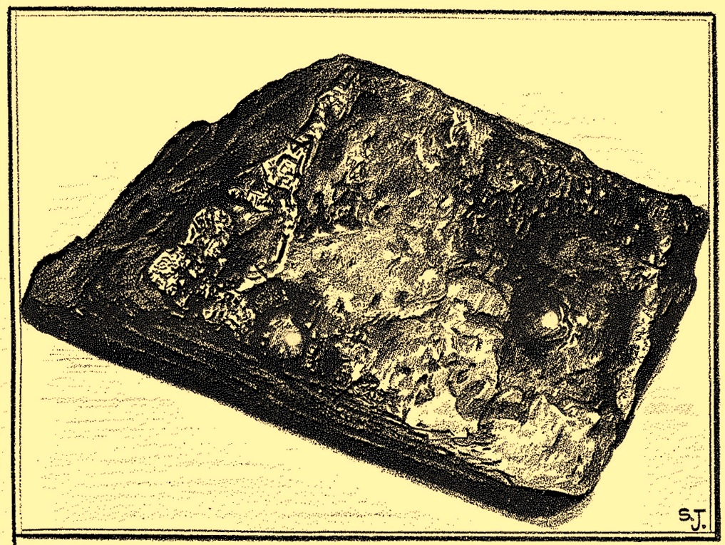
Sid Jackson’s vague drawing of the carving
“the discovery a few yards away of a small stone bearing a cup-and-ring mark providing evidence for at least one other symbol from this small hill. This stone, only 14in long, 8in wide, and 6½in thick, has a cup 1¾in in diameter, ⅞in deep with a shallow channel 1½ long running from it.
“Round the cup, which is very symmetrical and has the pecking clearly defined, is part of a concentric channel which, if it were a complete circle, would have a diameter of 4in. The channel, which starts near to the small channel that runs from the cup, goes only halfway round the cup and is obviously unfinished. It is irregular in width and depth and in marked contrast to the workmanship of the cup.”
He then queries as to whether this small carved stone could have come off the larger cup-marked Bucking Hill (02) boulder close by. We may never know, but when we consider the lack of general erosion on this cup-and-ring (the pecking was still visible), it would obviously have remained upside-down in the peat for a few thousand years! There was an old cairn a short distance away on the top of Bucking Hill and it may have come from there. Anyhow, Mr Feather subsequenly took this portable carving home with him and it’s subsequently been donated to the Ilkley Manor House Museum where it should be visible. (can someone send us a photo so we can add it to the site profile?)
References:
Boughey, Keith & Vickerman, E.A., Prehistoric Rock Art of the West Riding, WYAS 2003.
Feather, Stuart, “Mid-Wharfedale Cup-and-Ring Markings – Nos 21 and 22: Bucking Hill, High Moor, Rombald’s Moor,” in Bradford Cartwright Hall Archaeology Group Bulletin, 9:5, 1964.
Hedges, John (ed.), The Carved Rocks on Rombalds Moor, WYMCC: Wakefield 1986.
Cup-Marked Stone: OS Grid Reference – SE 0844 4529
Archaeology & History
This was one of two carvings reported by Stuart Feather (1964) that were very close to each other (see Bucking Hill 3), both of which consisted of simplistic designs but which, he thought, may once have been part of the same rock. Its precise whereabouts are not known (the grid-ref is an approximation). He wrote:
“On the southern slopes of Bucking Hill, a fine gritstone rock 5ft 6in by 4ft 6in by 1ft 6in high, has a very clear cup-mark 2in in diameter and ½in deep carved 8in from the straight eastern edge of the rock.”
Feather thought that the edge of the rock had been cut and quarried for use in the boundary wall to the east. He may have been right.
References:
Boughey, Keith & Vickerman, E.A., Prehistoric Rock Art of the West Riding, WYAS 2003.
Feather, Stuart, “Mid-Wharfedale Cup-and-Ring Markings – Nos 21 and 22: Bucking Hill, High Moor, Rombald’s Moor,” in Bradford Cartwright Hall Archaeology Group Bulletin, 9:5, 1964.
Hedges, John (ed.), The Carved Rocks on Rombalds Moor, WYMCC: Wakefield 1986.
Cup-and-Ring Stone (lost): OS Grid Reference – SE 0828 4507
Archaeology & History
Described by Boughey & Vickerman (2003) as being located somewhere “below Dirk Hill Sike” in the Rivock woods plantation, this is (or was) a “medium, upstanding rock lying NW-SE (with) one possible heavily weathered large cup-and-ring: cup 75mm diam. and ring 200mm diam.” However, the authors give no references to this site, nor images, or notes as to who rediscovered this stone. In their survey they also included one of the Bucking Hill carvings twice, giving the impression that there was more here than had previously been reported. These errors have subsequently been repeated elsewhere on-line. In saying this, there are a number of rocks scattered in this area which may have had carvings on them, but it’s been heavily forested and, recently, the trees have been felled and so many of them will have been damaged, turned over, or simply destroyed as a result of the forestry shennanigans.
References:
Boughey, Keith & Vickerman, E.A., Prehistoric Rock Art of the West Riding, WYAS 2003.
Coming via the Keighley-Bingley (Airedale) B6265 road, go up to Riddlesden and then up the winding Banks Lane until you reach the T-junction. Turn left here and about 330 yards along, on the right-side of the road is a dirt-track. Walk up here, sticking to the track (not the footpath) towards the cliffs of Rivock ahead of you, going through the gate and into the Rivock woods area. 450 yards on from the gate, on your right you’ll pass the long straight line of walling running uphill and literally 275 yards further along the track from here, walk straight up into the trees for 20 yards where, just before the slope begins to truly veer into an “uphill” state, you’ll see the stone in question!
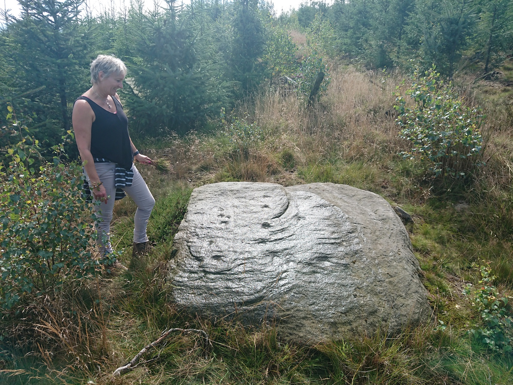
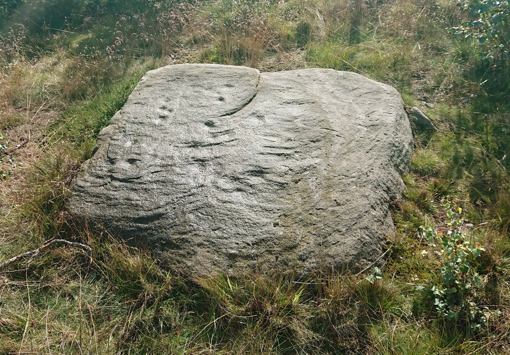
Archaeology & History
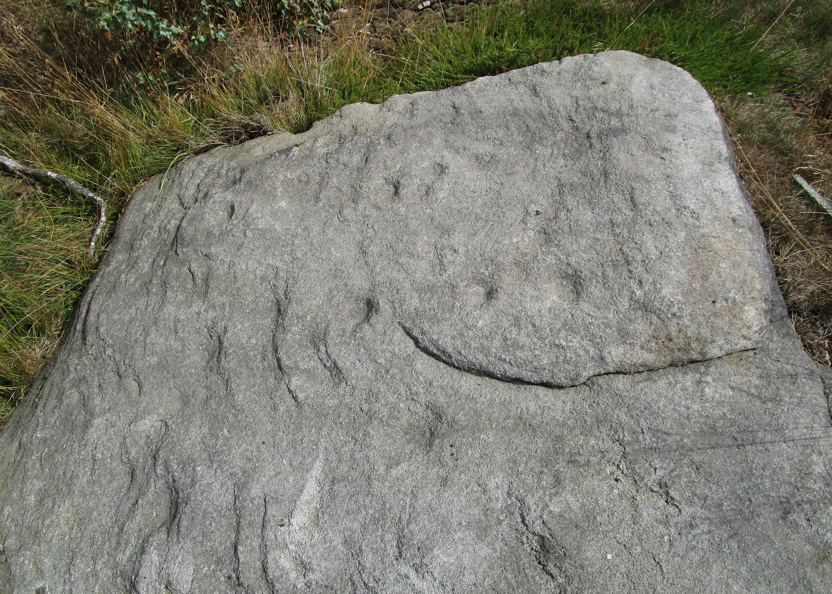
Cups on east-side of stone
In 1961 when Stuart Feather rediscovered this carving, the “rock was almost completely covered by a six-inch layer of peat and vegetation.” But, like all good rock art explorers, he slowly and carefully peeled it all back and brought back to light another one of Rivock’s olde stories. We know not what the story on the rock might tell, but it looks good nonetheless! Feather counted “several cups carved on it”, but a few more have ben discerned since then. When Boughey & Vickerman (2003) described it in their typically minimalist way, they told it be a “large square rock with surface in slope of hill. About nineteen cups.” Evocative stuff!
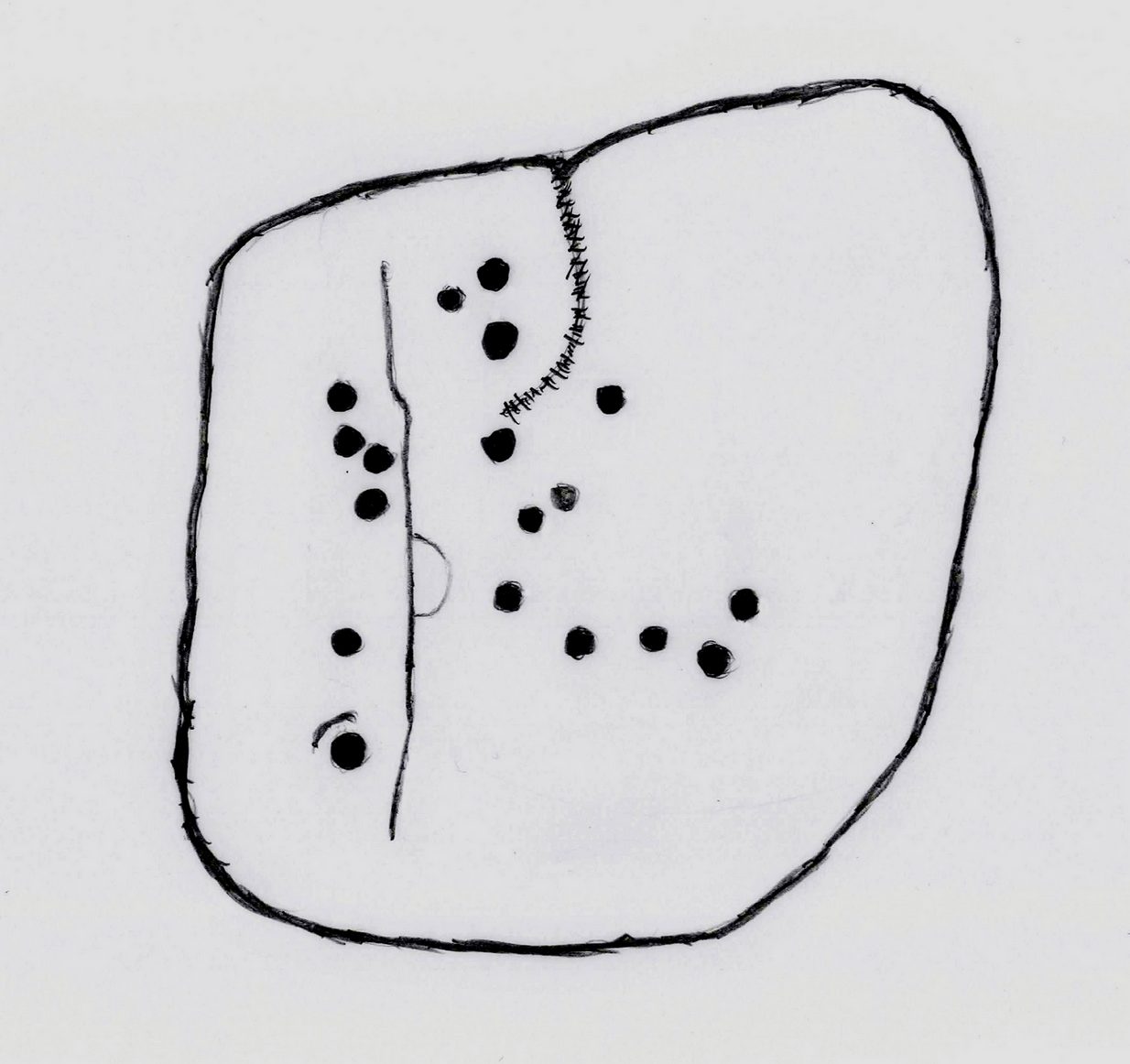
Sketch of basic designFaint line visible, left-side
When I first saw visited this carving as a young lad, the thing which stood out to me more than anything was the long but faint line that ran down one section of the stone. Added to this was an equally faint arc attached to the side of the line, like a “D” form. A few months later I did a sketch of it on my second visit, but I’ve looked and looked and seem to have lost it. (not good) The one I’ve done here is a recent one. As we can see, a series of cup-marks straddle each side of the D-line and are plainly visible, which implies that the line was carved much earlier than the cups. Of course, it’s possible that the cups were repeatedly forged over and over many times over a century or more and the D-line, for whatever reason, left untouched.
Another interesting aspect of this D-line is its repetition in the much more ornate petroglyph 35 yards to the east (presently known as Rivock 67 until we devise something more appropriate). The recently rediscovered Slinger Stone 100 yards south may also have the same feature, but this needs further surveying before we can say for sure.
References:
Bennett, Paul, ‘The Prehistoric Rock Art and Megalithic Remains of Rivock & District (2 parts),’ in Earth, 3-4, 1986.
Boughey, Keith & Vickerman, E.A., Prehistoric Rock Art of the West Riding, WYAS 2003.
Feather, Stuart, ‘Mid-Wharfedale Cup-and-Ring Markings: No. 14, Rivock,’ in Cartwright Hall Archaeology Group Bulletin, 7:1, 1962.
Hedges, John (ed.), The Carved Rocks on Rombald’s Moor, WYMCC: Wakefield 1986.
Acknowledgements: With thanks to Andy Roberts for giving this stone its modern name.
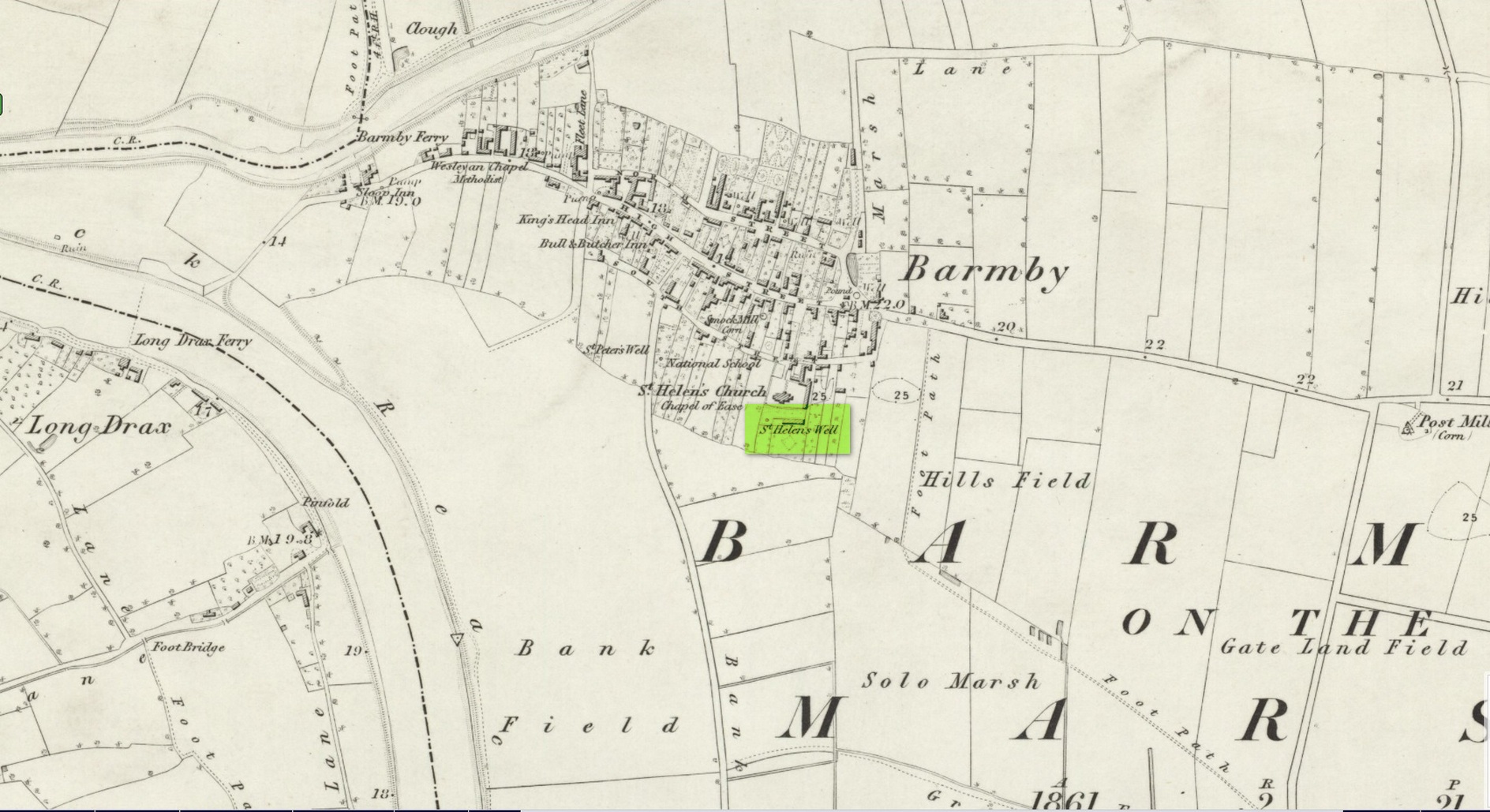
Holy Well (destroyed): OS Grid Reference – SE 6900 2841
Archaeology & History
Site shown on 1853 map
One of two holy wells in Barmby village which, like its compatriot St Peter’s Well, was destroyed sometime in the 19th century. Not good! It was located in the southwest section of the graveyard of St Helen’s Church and was apparently alive and running when the Ordnance Survey lads visited here in 1851 (as shown on their 1853 map). But when the site was revisited by them in 1905, it seems to have gone. However, as with the neighbouring St Peter’s Well, there are conflicting reports as to when it was destroyed, for although the Ordnance Survey lads spoke of it in the present tense when they went there, Thomas Allen (1831) told that “within the last six years (it has) been wantonly filled up.” Despite this, less than ten years later William White mentioned it in the present tense, also saying how it was “said to possess medicinal properties.” These healing qualities were, according to Allen, due to its iron-bearing or chalybeate nature, meaning that it would revive a weak and feeble constitution. Iron-bearing wells are damn good for such things!
As the years passed, St. Helen’s Well fell into folk memory. When William Smith (1923) surveyed the many holy wells in this part of the world he found how “old parishioners have said that as school-children they both drank of and washed in its water”, but little else.
References:
Allen, Thomas, A New and Complete History of the County of York – volume 2, I.T. Hinton: London 1831.
Gutch, E., Examples of Printed Folk-lore Concerning the East Riding of Yorkshire, Folk-Lore Society: London 1912.
Harte, Jeremy, English Holy Wells – volume 2, Heart of Albion press: Wymeswold 2008.
Smith, William, Ancient Springs and Streams of the East Riding of Yorkshire, A. Brown: Hull 1923.
White, William, History, Gazetteer and Directory of the East and North Ridings of Yorkshire, R. Leader: Sheffield 1840.
Cross (destroyed): OS Grid Reference – SJ 2534 7208
Archaeology & History
Actual location of the cross
This long-gone site, described in the Domesday Record of 1086 as Atiscros Hund, (or “hundred”, which is the word given to an administrative division of land which, at that time, was on the western edge of Cheshire bordering Wales), gained its title from an old English personal name, Æti. The fact that it stood on an ancient boundary and was included in Domesday, means it would have been a stone cross. Its location was shown on the 1871 Ordnance Survey map (and several subsequent ones), based on traditional accounts about its position. The site is still preserved in local street-names.
Referring to the monument itself, Thomas Pennant (1796) said that it still existed in his day, telling that,
“A cross stood there, the pedestal of which I remember to have seen standing. There is a tradition that, in very old times, there stood a large town at this place; and, it is said, the foundations of buildings have been frequently turned up by the plough.”
References:
Dodgson, J.M., The Place-Names of Cheshire – volume 4, Cambridge University Press 1972.
Pennant, Thomas, The History of the Parishes of Whiteford and Holywell, B. & J. White: London 1796.
Taylor, Henry, Historic Notices, with Topographical and other Gleanings Descriptive of the Borough and County-Town of Flint, Elliot Stock: London 1883.
Tumuli (destroyed): OS Grid Reference – NU 273 046
Archaeology & History
In a lengthy letter describing the cist burial at Cliff House, its author, Mr W. Dunn (1857) told that there were additional prehistoric remains nearby, that had only recently been destroyed. He told:
“It appears that, a few years ago, in the immediate proximity of the present discovery (at Cliff House, Ed.) two or more tumuli were found which contained urns and bones; and flint arrow heads of elaborate finish have been occasionally met with.”
I can find no additional information about these sites.
In the same article, a Mr Kell told that during the construction of the Amble piers a half-mile to the west, “some years ago, he was sojourning in the neighbourhood, and …human remains were found on the removal of sand by the waves in a violent gale from the East.” What else is known of this place?
References:
Dunn, W., “Ancient Sepulchral Remains,” in Proceedings Society of Antiquaries Newcastle-upon-Tyne, volume 1, no.34, 1857.
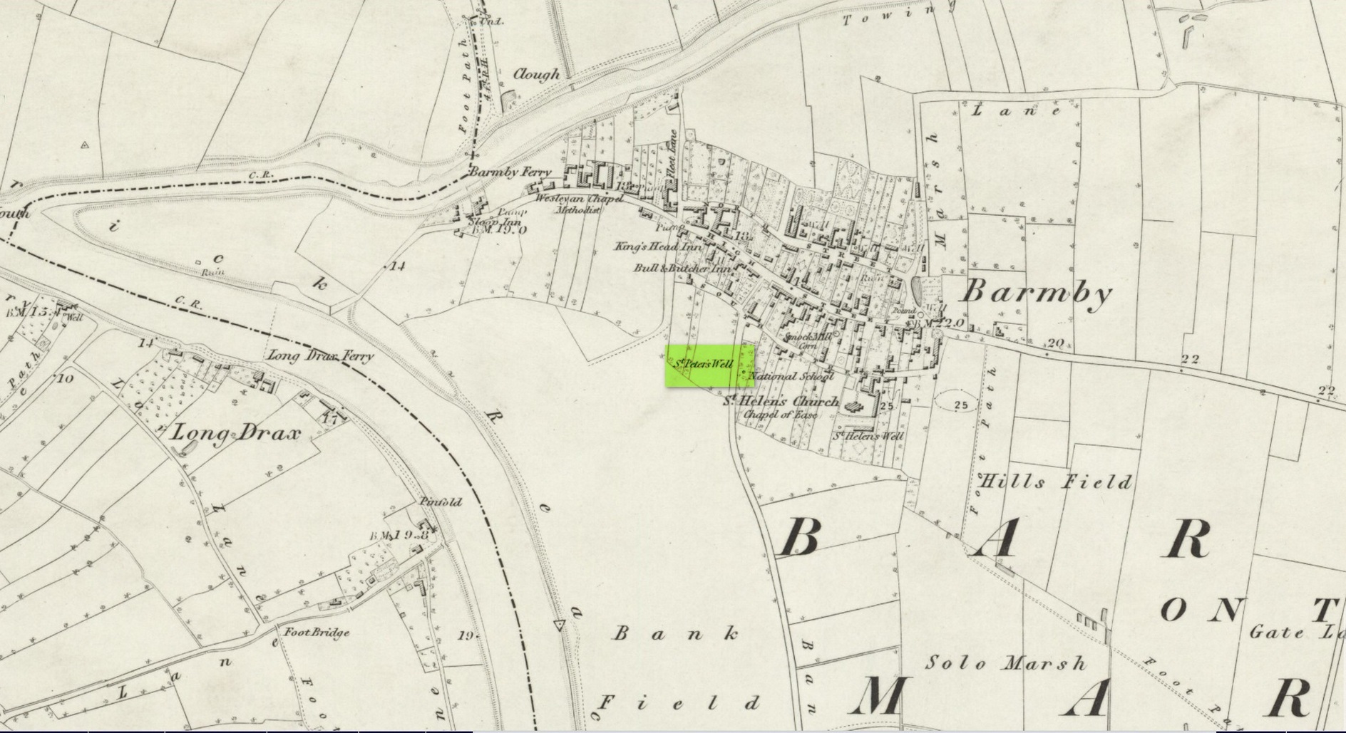
This holy well was one of two in the village of Barmby, neither of which seems to exist anymore — although, it has to be said, there are conflicting reports as to its demise from the word go. When it was first mentioned in Thomas Allen’s (1831) huge work on the history of Yorkshire he told us that,
“In this village are two extraordinary springs of sulphuric and chalybeate water, denominated St Peter’s and St Helen’s; the former possesses the rare virtue of curing scorbutic eruptions by external application. Both of these wells, within the last six years, have been wantonly filled up, and the site is only known to a few of the villagers.”
Their “extraordinary” waters however, were apparently found to be still flowing when the Ordnance Survey lads surveyed here in 1849, as they published it a few years later on the 1853 OS-map of the region, along with its nearby compatriot of St Helen.
Wet patch on 1907 mapSt Peters Well, Barmby 1853
Less than ten years earlier, Will White (1840) also spoke of St Peter’s Well, albeit briefly, telling that it “was said to possess medicinal properties”—but it seems that he never visited the site and was merely going on Mr Allen’s earlier description. Its exact whereabouts however, is somewhat of a curiosity. Although the Ordnance Survey lads mapped it as being SE 6885 2848 on the southwest side of the village, in William Smith’s (1923) survey of holy wells he gave us a very different location. “St Peter’s Well,” he wrote,
“is situated in an orchard about a hundred yards to the south-east of the church, and is reached by going through three fields. It is a pool about eight feet deep and fifteen in diameter, the spring now rising several yards from its original site. It flows clear and strong, and though attempts have been made to block it up, it always reappears. The water is soft and has never been known to freeze. It contains sulphur, as I can testify, having tasted the water. It is noted for curing scurvy and sore eyes, if applied externally, and half-a-century ago, people suffering from these ailments came long distances to apply the water as a remedy, and went away benefited. An eye-witness has said a man living far from Barmby, advised by his medical man, as a last resort visited the well and applied the water externally for the cure of scurvy, and so quickly did he lose the scales that fresh sheets for his bed were required each night…
“About a century ago, the owner of the orchard in which the well is situated had a son, a doctor, who commenced to practice in the district. The owner’s wife looked upon the spring as detrimental to the prospects of the son. So she said to her husband, “Tummus, we’ll hev that well filled oop. Foaks can cure thersens, an’ ther’ll be nowt fur poor Tummy ti dea.” Tummus was so convinced by his wife’s foresight that he did as she wished, and filled up the well.”
Naathen, on the very first OS-map of the village, the lads marked it at SE 6885 2848, as well as on subsequent surveys. This spot is 170 yards west of the village church wall. The location described by Smith has no “well” or spring marked on any maps, but, on the 25-inch scale map, 100 yards southeast of the the church walling we see marshland on the other side of a copse of trees in the very spot he told us about. Whether or not this was the actual spot, or whether the OS-lads had it right, we might never know. Field-name surveys may help; the existence and location of the orchard may help; other literary accounts might also be useful. But, one final query that may be important relates to Tom Allen’s (1831) words when he told us that “the site is only known to a few of the villagers.” By that, did he mean that the local folk kept its position quiet from outsiders? Even today, in our numerous inquiries with local people in the glens and mountains when seeking out lost or forgotten places, we still come across some olde local folk who are still quite hesitant, with that serious quizzical look in their eyes…
Folklore
St Peter’s day was celebrated on June 29. He was one of the so-called “major saints” due to him being one JC’s Apostles. His symbol was a key.
References:
Allen, Thomas, A New and Complete History of the County of York – volume 2, I.T. Hinton: London 1831.
Gutch, E., Examples of Printed Folk-lore Concerning the East Riding of Yorkshire, Folk-Lore Society: London 1912.
Harte, Jeremy, English Holy Wells – volume 2, Heart of Albion press: Wymeswold 2008.
Smith, William, Ancient Springs and Streams of the East Riding of Yorkshire, A. Brown: Hull 1923.
White, William, History, Gazetteer and Directory of the East and North Ridings of Yorkshire, R. Leader: Sheffield 1840.
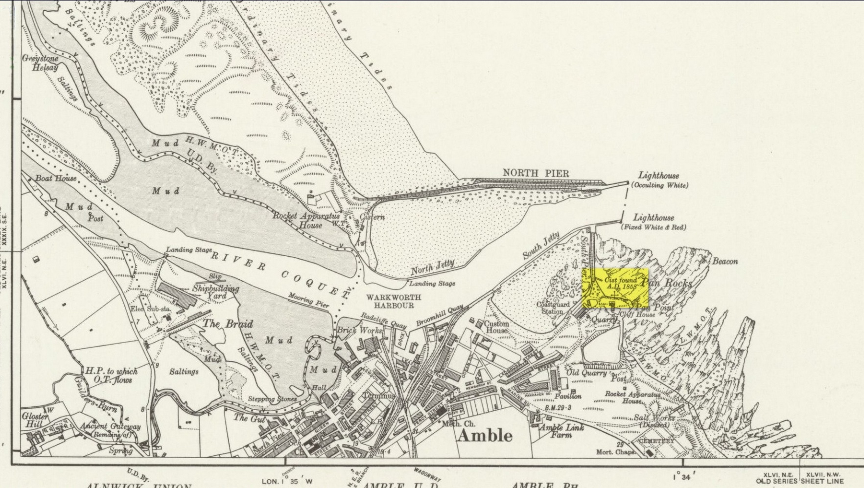
Cist (destroyed): OS Grid Reference – NU 2730 0486
Archaeology & History
Site location on 1926 map
In November 1857, Collingwood Bruce read out a paper that had been sent to him by the Rector of Warkworth village (Rev. W. Dunn), describing “ancient sepulchral remains” that had been found near the cliff-edge above Pan Rocks near Amble’s lighthouse. It was a lengthy account which, in passing, also mentioned several other prehistoric sites close by that have long since been destroyed and which we have very little information about. Mr Dunn’s (1857) letter told:
“In the middle of April last, about 50 yards NE of the Cliff House, Amble, and about 20 yards from the end of what is called Warkworth South Pier, the pilots came upon a long upright stone, standing out of the shale to the height of twelve or fourteen inches,which had been laid bare by the recent heavy gales, but which, from its rude appearance, did not afford the idea of anything beyond a mere accidental tilting. Alongside this upright stone was a large unwrought slab, which, on being raised, was found to be the covering of a cist or sepulchral chamber containing a perfect skeleton. The figure was lying on its left side, with the head to the south-west, having the knees much doubled and with the right arm thrown back. By its side stood an urn of unbaked clay. This urn, now in the Museum of the Duke of Northumberland, resembles in size and shape that which was found a few years since at Hawkhill, and which is preserved in the Museum of the Antiquarian Society of Newcastle. It contained a small quantity of dark earth.
“Having given this general outline of the discovery, I shall proceed to offer such observations as I have been able to make,and have considered worth recording. I grieve to say that before the period of my visit the spoiler had been busy with these venerable remains. The skull had been broken up, the jaws smashed, every tooth appropriated, and the bones indiscriminately mingled, after many a century of undisturbed repose.
“The cist or chamber containing the remains was composed of four slabs inserted edge-wise in a cavity which appeared to have been dug out of the friable shale which lies upon the harder rock in this locality. It ranged south-east and north-west, and measured as follows: depth, 18½ inches; width, 26 inches; length at bottom, 4 feet; at top, 3 ft 4 in.; the difference between top and bottom measurements being accounted for by the shrinking of the ends. The cavity in the shale was much larger than the cist, and the space between the slabs and the shale was closely filled-in with stones, roughly broken, commingled with earth and larger stones. The side slabs projected somewhat beyond the ends. The bottom of the cist was covered to the depth of about half an inch, with dark, unctuous mould. Amongst the rubbish comprising the filling-up of the space above-mentioned, was found an angular piece of silex, probably an unfinished arrowhead; and in the south-west corner of the cist lay a large, smooth cobble stone, which, when considered in conjunction with the flint flake, the imagination may easily construe into the club of this ancient denizen of our shores. The slab which constituted the cover of the cist was of great size and extended in every direction considerably beyond it; and the upright stone was set up, not at one of the ends, but along its length. It is remarkable that a close inspection of these stones gave no trace of chisel-marks in any part. In order that the cover might lie level, pieces of shale, flags, etc., were laid on the uprights which formed the cist, wherever an irregularity presented itself.
“Within the memory of man, the rock ran out from this point for some yards into the sea at a considerable elevation; but the construction of a pier in the immediate neighbourhood has caused the removal of much of the stone, and the spray of our wild sea waves now dashes over the spot which for countless generations may have been peacefully tenanted by these nameless bones. At the same time, it does not appear probable that at any period there has been at this particular point a very deep covering of the sand and bent-grass which are found thick and rank upon the adjacent links.
“The skull must have been very characteristic, having attracted general observation from the extraordinary lowness of the frontal region, the great development of the occipital portion of the head, and the width and length of the lower jaw from its anterior junction to the articulation of the temporal bone. One person observed that during life the man “must have measured as much to the top of his eyebrows as to the top of his head.” The teeth are said to have been very beautiful and regular, and quite sound. With the exception of a front tooth, which was missing in the lower jaw, they were perfect. The thigh-bone measured 19½ inches, indicating a man of large size; whilst the porous internal organization of the bones gave probable evidence of comparative youth.
“The urn is unbaked, of a light clay colour, and measures in height 8 inches, in depth 7¼ inches, and in diameter 5½ inches. It is ornamented with zigzag scoring, alternating with dotted lines,and upright (and sometimes slanting) scorings, which appear to have been made with some rude instrument whilst the clay was moist. The scorings are continued over the edge of the rim. On being rather roughly seized by one of the men, it being expected that it contained treasure, a piece was broken off; but no material injury has been occasioned. The stone found in the cist does not resemble any that one may pick up on the neighbouring shore, and attracted attention from its bearing no assignable relation to what I may call the masonry of the tomb. I have since learnt that stones are not infrequently found in Teutonic graves on the Continent, and that recently a singular oval stone was found in a tumulus on Petersfield Heath.”
All trace of this site has disappeared. Mr Bruce posited the idea that the round stone in the cist may have been the one that ended the life of the buried man! An intriguing thought. And that the urn “no doubt, contained some portion of the feast prepared on the occasion of his funeral.”
References:
Dunn, W., “Ancient Sepulchral Remains,” in Proceedings Society of Antiquaries Newcastle-upon-Tyne, volume 1, no.34, 1857.
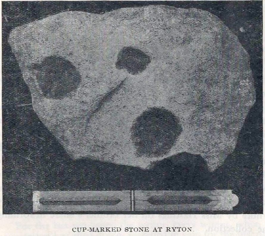
Cup-Marked Stone (removed): OS Grid Reference – NZ 1480 6417
Archaeology & History
Ryton cup-marked stone
In a short piece read before Newcastle’s Society of Antiquaries in 1942, a Mr Cocks (don’t laugh!) told that when a friend of his was clearing out an old land drain in his garden, he found this fragmented cup-marked stone, “which had been made use of as a corner slab on the drain”! It was located “about 40 yards south-west of Tweedy’s Buildings,” on the west side of town. Broken from a larger piece of stone, the attached photo here shows the simple design of the basic cup-marks, measuring respectively 2½, 2 and 1⅝ inches across. Mr Cocks told that “there are also two finger-tip hollows on the stone tone which or may not be natural. A dark line running between the cups is a natural fissure.”
Last we heard, the stone was living in a box somewhere in the archives at the Great North Museum, Newcastle.
References:
Cocks, W.A., “A Cup-Marked Stone at Ryton,” in Proceedings Society of Antiquaries Newcastle-upon-Tyne, volume X, no.2, January 1943.