To search for any sites in the northern counties of England (previously known as Brigantia), click on the list of relevant counties, below. Please note that not all these english counties were truly in Brigantia, but they came close to its southern edges; and as parts of them tickle the edges of the southern Pennines, I thought they should be included. Hope that’s OK with everyone!
Maypole (destroyed): OS Grid Reference – SE 0458 9121
Redmire’s ancient Oak
Archaeology & History
As with many of Britain’s old maypoles, the one at Redmire has long since disappeared and no local in the 20th century appears to have had any memory of it. However, it was mentioned in Victorian times and described in McGregor’s (1989) fine history work on the village:
“At one time, somewhere on the Green, stood a maypole which was destroyed by lightning. I never heard the memory of it recalled during my early life, but it is mentioned in their books by both Barker and Bogg. The remnants of it appear to have been there in 1850 or 1852, as Barker, writing at that time says, ‘A maypole, rare in Yorkshire, stands on the Green. It was shivered to pieces by the electric fluid, during a thunderstorm, in the summer of 1849. This poor maypoles catastrophe would have been regarded by the old Puritans as a direct and visible manifestation of the wrath of heaven at such a heathenish practice.’ Redmire, as we know, took pleasure in dancing in the 19th century, and continued to do so, especially after the building of the Town Hall…”
When Edmund Bogg came here at the end of th 19th century, he saw “the base of the ancient maypole…near to, a twisted and ancient oak” whose ancient branches were being held upright by large wooden posts. This sacred oak itself was said to “still cast its shade over a small spring of water.” Unfortunately I ‘ve found no more about this lost pagan relic…
References:
Barker, W.G.M.J., The Three Days of Wensleydale, Charles Dolman: London 1854.
Bogg, Edmund, Wensleydale and the Lower Vale of Yore, E. Bogg: Leeds n.d. (c.1900)
McGregor, Isabelle, Redmire – A Patchwork of its History, privately printed: Redmire 1989.
The huge stone trough at the side of the Wycoller Beck further down than the old bridge had a pipe leading to it from a spring on the other side of the beck. Cookson & Hindle (1974) told that this was “the only source of drinking water” — which wasn’t quite true. In the old photo shown here, the groove in the supporting vertical stone once held a lid over the top of the trough, “to prevent animals, dead leaves, etc, from fouling it.” In addition to the old photo shown here, the well is also illustrated in Folley’s Romantic Wycoller (1949) with two young girls drinking the running water.
References:
Bentley, John, Portrait of Wycoller, Nelson Local History Society 1975.
Cookson, Stanley & Hindle, Herbert, Wycoller Country Park, H. Hindle: Colne 1974.
Folley, E.W., Romantic Wycoller, Coulton & Co.: Nelson 1949.
From Ilkley town centre, taken the road north across the River Wharfe, turning left and up the country lane towards Nesfield. As you’re driving with the farmed fields on either side, you’ll go round a couple of swerves in the lane and reach the open moorland on your right, just past the small copse of trees on the same side. There’s a small place to pullover on the right 100 yards on and walk up the footpath running northeast onto the moor. Go past the disused quarry and up further till you reach the rounded hill where the tumulus stands.
Archaeology & History
On the moors north of Ilkley – as shown on OS-maps since the 1850s – on the southeastern edge of Middleton Moor, is this singular tumulus, a short distance west of some old quarrying at the curiously-named Lurgy Delf. The small hill is easy to find and appears at the western edge of a whole host of neolithic and Bronze Age remains. It is included as a boundary marker between Middleton and Langbar, as marked by an old stone on its southern side. Eric Cowling (1946) described this as “a spread of stones on Round Hill” in the same context as other burial mounds and cairns in the region, also naming it as the Black Hill tumulus. Many flints had been found all round here and it stands at the western edge of a great number of cup-and-ring stones, stretching eastwards across the moors for several miles. To my knowledge, no excavation has taken place here.
References:
Cowling, Eric T., Rombald’s Way, William Walker: Otley 1946.
Very little can be seen of this once large oval-shaped prehistoric enclosure, a mile south of Slaidburn, on the level below the rise towards Easington Fell. Few archaeologists know about the site and there has been little written about it. Although very little of it is visible at ground level today, three-quarters of the site is vaguely discernible from the air and on GoogleEarth, as the photo here shows. The Skelshaw Ring was described in Greenwood & Bolton’s Bolland Forest (1955), where they said, “The late Colonel Parker (Browsholme Hall) claimed to have found a good specimen of an ancient earthwork above Easington Green. Unfortunately, this has been ploughed over during the last war (WWII).” And little else appears to have been said of the place until the Lancastrian writer John Dixon (2003) wrote about it. More recently John said the following about the site:
Skelshaw Ring plan (after Dixon 2003)
“This oval earthwork, 320 ft. diameter, crowns a small hill on the general slope of the east bank of Easington Beck. It consists of a ditch and bank with a gateway through the bank and a causeway across the ditch on the west side. Inside the bank and ditch the ground rises gently into a rounded hill so that most of the inside of the earthwork is well above the level of the bank.
“During the spring of 1934 a preliminary excavation of the site was undertaken by the late Dr. Arthur Raistrick. Three sections were cut through the ditch and bank and the inner area was briefly explored.
“Although nothing was obtained to date the earthwork, the sections did show the ordered structure of the site and proved the presence of large floors that may well have been the site of huts.
“This site may be compared with the large ringwork at Fair Oak Farm, SD 648 458, as both have a similar size and the same features are displayed. Bleasdale Circle, SD 577 460, is a slightly smaller ringwork, but I consider all three monument (plus: Easington Fell Circle [no:2] SD 717 492 ) to have the same origins.
“These earthworks represent the first settlements of a people determined to tame, settle and cultivate the landscape. What we observe at Skelshaw is the possible farmstead of an extended family unit, part of a clan that worked the land here some 4000 years ago in what is referred to as the Bronze Technology Period.”
Go through the gorgeous old village of Waddington northwards, uphill, along the B6478 road, towards the villages of Newton and Slaidburn; or, if you like, go from Newton village uphill southwards along the B6478 road towards Waddington. Either way, when you reach the top of the moors, park up at the car-park beside the road where the view stretches for miles ahead of you. Walk on the road for 100 yards, then take the boggy footpath left, going first down and over a stream, then up to the right (northeast) towards a small cairn on the near-horizon. From the cairn-top you’ll notice a large moorland pond a hundred or so yards ahead of you. Walk towards and past its left side and onwards again for the same distance until, in front of you (before a nearly-dried stream running downhill) keep your eyes peeled in the deep grasses on where you’ll see a very large ring raised in front of you, defined in parts by scatterings of rocks along the tops and sides. You’re here!
Archaeology & History
This is an outstanding prehistoric site, all but lost in old literary records until relocated in recent years by Lancashire historian and writer, John Dixon. However, its precise nature remains a bit of a puzzle. When John took a small party of us to the site on June 16, 2011, there was a variety of ideas as to the precise nature of the place.
Southwestern arc of the Ring
Structurally similar to a number of prehistoric enclosures in the Pennine range, this very large near-circular monument consists primarily of a very large number of rocks and stones making up a thick outer wall, presently piled less than a yard high above the peat and approximately 6 feet wide on average. From north-to-south, outer wall to outer wall, it measures more than 42 yards (38.5m) across; whilst measuring 41 yards (38m) east-to-west. There are distinct entrances on its western and northern sides, and possibly another on the east. Certain sections of the inner region are now somewhat boggy in parts, perhaps indicating there was at one time an internal spring of water. A large singular stone is found on the inner eastern section, which may have been placed there deliberately. On the northwestern inner-edge of the walling is a notable long wide stone which may have stood upright.
My first impression of the site told it to bet at least Iron Age in date, though more probably Bronze Age. But without excavations, I could be talking bullshit! It is an obvious enclosure of some sort, but there are no visible internal structures on the present ground level. There are no notable internal or external ditches and banks, which may have given the site a ‘henge’ classification. More work is obviously needed here before we can say what it is for sure.
Very little has been said of this huge ring in the past. John Dixon’s research found the site briefly described in Greenwood & Bolton’s (1955) work, saying:
“On page 24 they refer to the above site thus: ‘There is also a rough stone circle on top of the fells above Easington, like the remains of an ancient fort (the ringwork)…'”
Also mentioning how Richard Rauthmell’s Antiquitates (1746) very briefly mentions the place aswell. Apart from these passing remarks, John has found little else.
On other parts of this moortop we found scattered evidences of other early human remains (walling, cairns, hut circles), much of it unrecorded. There may well be other important prehistoric remains hidden upon these hills…
An intriguing and little-known carved stone whose existence has been brought to our attention by historian and author John Dixon. Its precise history and nature seems unknown; but aspects of the carving possess symbols that are found on early christian remains, as well as some cup-and-ring designs. John wrote:
Artist’s impressionFoulscales Stone
“This enigmatic stone (27 inches height, 12 inches wide, 6 inch thickness), anciently known as the Yolstone and later as the Bonstone, once stood behind Foulscales Farm, near Gibbs. For some reason the stone was removed from this site and taken into the cellars of Knowlmere Manor under the authority of the Peel Estate.
The stone displays possible early native chi-rho symbols that may have a 6/7th century provenance. The lettering ‘HT’ look to be of 16/17th century origin and may refer to the Towneley family who held lands in Bowland.”
Was it a boundary stone? A gravestone? Was it an early christian stone? A Romano-British stone? The carved circles with ‘crosses’ inside them are typical Romano-British period designs, covered extensively in the early works of J. Romilly Allen and found to be widespread across Britain. Any further information on this stone would be greatly appreciated.
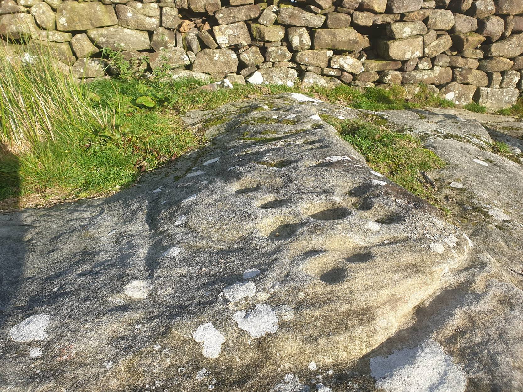
From Masham take the Fearby Road & go through the village, onwards & past Healey village and less than a mile on where the road forks, bear to the right past and go along the gorgeous little-known vale of Colsterdale. Less than 2 miles on, walk up the notable track veering to your right that goes diagonally uphill and past the bottom of West Agra farm along the wallside till you reach the gate. Thru the gate, walk immediately uphill on your right following the walling for a coupla hundred yards until you reach another gate into the field on your right. You’ll see a cluster of large boulders in the first field, which you need to walk past and look at the large boulder up against the walling in the next field. You can’t miss it!
Archaeology & History
Photo by Geoff Watson
First mentioned — albeit briefly — in Brown’s (2008) work, this large bedrock stone, covered down its eastern side by a line of drystone walling, has a good scattering of cups and lines, mainly on its central and westerly side. A cluster of them were etched onto a natural rise near the middle of the rock, which itself has a long circuitous line running around its northern and western sides, which you can just see below centre in the photo (below left). Altogether on this side of the rock surface there appears to be some 56 cup-marks plus a number of long carved grooves curling in differing directions: some of these appear to have been Nature’s handiwork that were subsequently modified by human hands. It’s an impressive-looking petroglyph.
Main rock surfaceCluster of cups – by QDanT
If we go over to the other side of the walling, we find more cup-markings. This discovery led Paul & Barbara Brown (2008) to classify the site as being two separate carved rocks — calling them 3a and 3b — thinking that the much smaller carved area on the other side of the wall, “may have originated from WAP 3a’s quarried southern section.” On this smaller section we find some 7 cup-markings with possible carved lines running off the edge of the stone and some running roughly parallel to the walling. Whatever the truth of the Browns’ assertion, this is a fine carving well worth looking at!
References:
Brown, Paul & Barbara, Prehistoric Rock Art in the Northern Dales, Tempus: Stroud 2008.
From Masham, take the Fearby Road to the village, keep going on the same road through Healey village and less than a mile on where the road forks, bear to the right past and go along the gorgeous little-known vale of Colsterdale. It’s bloody beautiful! Less than 2 miles on, walk up the notable track veering to your right that goes diagonally uphill and past the bottom of West Agra farm along the wallside till you get to the gate. Thru the gate, follow the wall immediately uphill to the right for a coupla hundred yards until you reach a gate into the field on your right. The cluster of large boulders in front of you is where you need to be!
Archaeology & History
Cluster of cups on WAP-2b (image by ‘QDanT’)
This carving is to be found on the largest of the boulders in this cluster. It’s a large scattered cluster of cup-markings and natural bowls all over the rolling surface of the rock. It was first described in the Browns’ (2008) survey, although as they have given this and one of the adjacent stones incorrect grid-references, it made it troublesome to initially work out which carving was which! But the photos here certainly lets you know which one I’m describing! In the event that I’ve got the wrong title for this one, someone lemme know and I’ll remedy the situation!
Brown (2008) describes this design as being “cups some linked by grooves, a rectangular feature and eroded cups and depressions.” We couldn’t work out any further elements on the stone, but the cloudy conditions when we were here prohibited a decent view of the surface.
References:
Brown, Paul & Barbara, Prehistoric Rock Art in the Northern Dales, Tempus: Stroud 2008.
From Masham, take the Fearby Road to the village, keep going on the same road through Healey village and less than a mile on where the road forks, bear to the right past and go along the gorgeous little-known vale of Colsterdale. It’s bloody beautiful! Less than 2 miles on, walk up the notable track veering to your right that goes diagonally uphill and past the bottom of West Agra farm along the wallside till you get to the gate. Thru the gate, follow the wall immediately uphill to the right and, about 100 yards up, watch out for the large flat stone by the side of the footpath. You can’t really miss it.
Archaeology & History
Initially we thought that this carving was one described in Paul Brown’s work as ‘West Agra Plantation no.1’, but this is clearly a different carved stone. It is found close to WAP-1 (as he called it), but a few yard further up alongside the footpath by the walling. With two large bowls on the top of the stone and another at the edge, two average-sized cup-markings are several inches away to the bottom-right of the largest bowl. What seems to be a carved line runs from one of the cups. We need to visit this stone again and look at it when there’s better lighting conditions so we can get a more accurate assessment of its nature.
References:
Brown, Paul & Barbara, Prehistoric Rock Art in the Northern Dales, Tempus: Stroud 2008.
From Masham, take the Fearby Road to the village, keep going on the same road through Healey village and less than a mile on where the road forks, bear to the right past and go along the gorgeous little-known vale of Colsterdale. It’s bloody beautiful! Less than 2 miles on, walk up the notable track veering to your right, diagonally uphill. Walk along till you get to the moor edge. Go thru the gate and follow the swerving uphill path to the bottom of Slipstone Crags. Once you level out at the Crags top, look across the small valley to your left and, on t’other side, you’ll notice a standing stone upright in the heather, just 100 yards on the flat on the other side of the valley. Head right for it!
Archaeology & History
Looking west
There are no known written references to this standing stone, which we visited for the first time yesterday, in a brief wander to the nearby Agra Woods cup-and-ring stones a few hundred yards southeast. The monolith stands some four-and-half-feet tall and, at its base, is more than three feet broad and just one foot wide. Just to its side and almost completely covered in peat and vegetation is what may have been another once-upright companion asleep in the Earth. Another possibly fallen stone is less than 10 yards west. The upright stands on the flat moorland overlooking the confluence of two (once) fast-flowing waters of Brown Beck and Birk Gill; and the landscape that reaches out from here is something to behold!
We found the remains of other old monuments on the moor, but some were obviously related to the industrial mining not far away. However, two or three other small upright stones and a large stone circular structure were also located which very obviously predated any industrial or medieval workings. We need to revisit this moorland and spend more time exploring to see what other things are hidden, lost midst the peat and heather.