Newell’s Well, Glentham, Lincolnshire

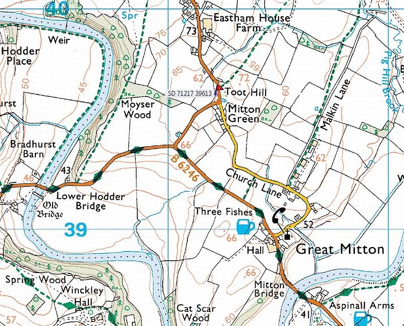
Holy Well:  OS Grid Reference – SK 981 897

Getting Here

Newll's Well, Glentham
Newll’s Well, Glentham

Leave Glentham on the way to Caenby Corner. You pass a footpath marked on the right-hand side (it goes to Highfield farm). The road makes a bend to the right and then before a slighter turn to the left, just before this last bend there is a little lane to the right. Park safely here and then there is copse. You will need to scramble down there and follow the small stream to its source. It runs almost just under the road.

Archaeology & History

Many wells have associations with seasonal customs, but perhaps one of the most unusual traditions is that found in the Glentham Parish in Lincolnshire. Here can be found the Newell or Newell’s Well which had associated with it a rather unique custom: the ceremony of ‘Washing Molly Grime’ The tradition appears to have become confused over the centuries. A full account is recorded by a H. Winn in Notes and Queries (1888-9):

“The church of Glentham was originally dedicated to Our Lady of Sorrows, a circumstance obviously alluded to by a sculpture in stone of the Virgin supporting the dead Christ in her arms, still to be seen over the porch entrance and placed there by some early representative of the Tourneys of Caenby, who had a mortuary chapel on the north side of Glentham church. The washing of the effigy of the dead Christ every Good Friday, and strewing of his bier with spring flowers previous to a mock entombment, was a special observance here. It was allowed to be done by virgins only, as many desired to take part in the ceremony being permitted to do so in mourning garb. The water for washing the image was carried in procession from Neu-well adjacent. A rent was charged of seven shillings a year was left upon some land at Glentham for the support of this custom, and was last paid by W. Thorpe, the owner, to seven old maids for the performance of washing the effigy each Good Friday. The custom being known as Molly Grime’s washing led to an erroneous idea that the rent charge was instituted by a spinster of that name, but ‘Molly Grime’ is clearly a corruption of the ‘Malgraen’ i.e. Holy Image washing, of an ancient local dialect. About 1832 the land was sold without any reservation of the rent charge.”

The origin for the wells name is also confused.  Rudkin (1936) notes:

“They reckon it’s called Newell’s well on account of a man named Newell as left money to seven poor widow women..”

However, it is more likely to be simply new well, perhaps deriving its name from ‘eau’, a common word in the county.

When and why the tradition switched from washing the holy image to that supposedly of the Tourney (Lady Anne Tourney a local 14th century land owner) is unclear, but it is possible that the change occurred at the Reformation and that perhaps the money was given to wash both holy image and that of the benefactor and post Reformation only the benefactor washing survived. There is a similar tradition called the ‘Dusters’ in Duffield.  The name of the activity clearly survived as Rudkin that:

 “ they’d wash a stone coffin-top as in the Church; this ‘ere coffin-top is in the form of a women. ‘Molly Grime’ they calls it.”

The tradition even appears to have earned some note nationwide, for a nursery rhyme about the custom is known:

Seven old maids, Seven old maids,
once upon a time, Got when they came
Came of Good Friday, Seven new shillings
To wash Molly Grime, In Charity’s name,
The water for washing, God bless the water
Was fetched from Newell, God bless the rhyme
And who Molly was I never heard tell. And God bless the old maids that washed Molly Grime

Sadly the selling of the land appeared to killed off the tradition, except that between 2004 and 2007 a special Father’s Day race for women was established. This involved filling a balloon with water from Newell’s spring and the subsequent attempt for getting it back to the village without bursting it. In essence it remembered the tradition, but sadly it too appears to have fallen into abeyance.

Folklore

Another tradition in the village was that if one drank its waters one was said never to leave the village. A correspondent of Sutton (1997) states:

 “An old boy told me about the ‘healing well of Glentham. It was named after a saint but I can’t remember the name he used. Some folk call it Newell’s well. Many people came to take the healing waters and in the spring of the year, the Church held an annual service for ‘good water for the rest of the year’, the service marked a new year of the waters. The well was dressed in a traditional way using clay and flower petals to make some kind of picture, usually a saint. I’m told it look very impressive”

This is presumably before the site was enveloped in scrub as it is now. The report is interesting for a number of reasons; firstly because the correspondent refers to the waters as healing, secondly that it was dedicated to a saint and thirdly the account of well dressing more reminiscent of Derbyshire, and as far as I am aware it is only such example, as well dressing at Welton and Louth appeared to be more garland related. None of these observations have been made elsewhere which either casts doubt in the correspondent or more likely the patchy nature of well traditions in the county.

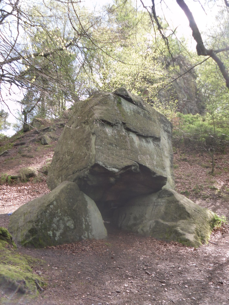
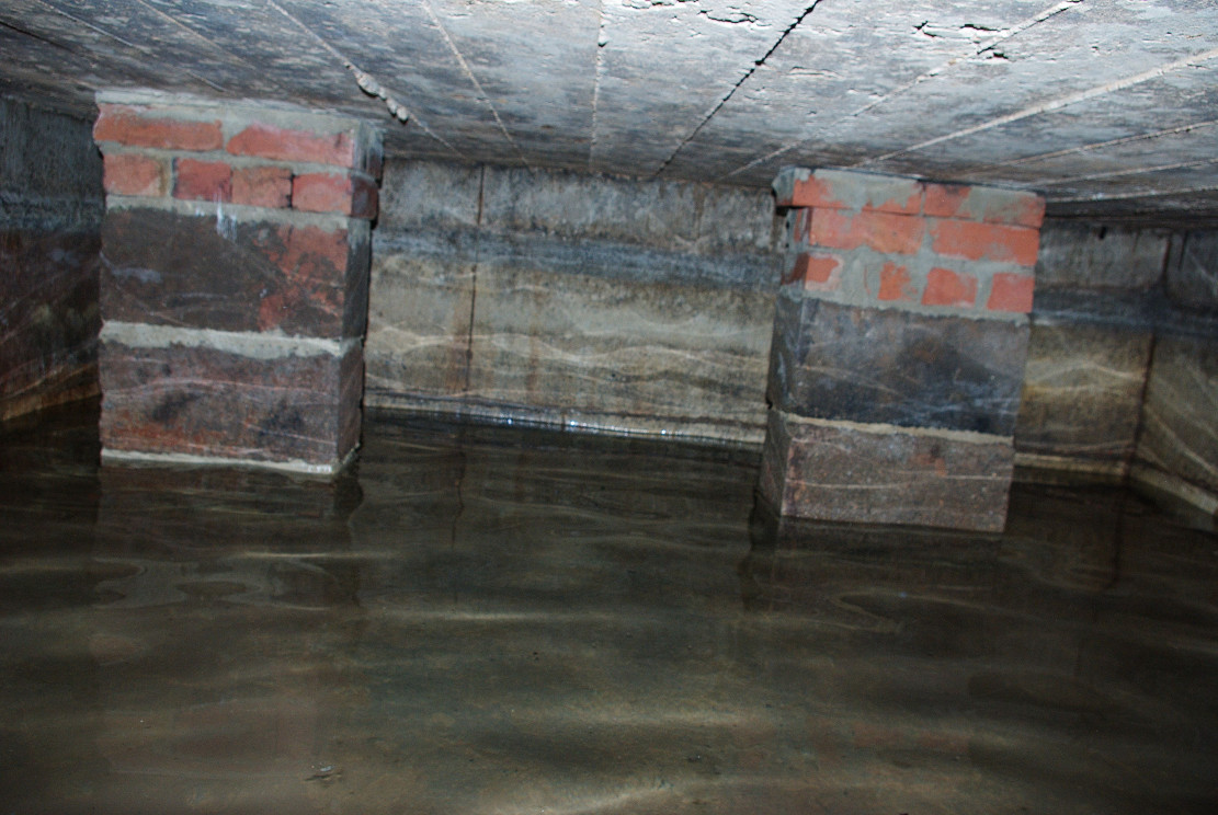
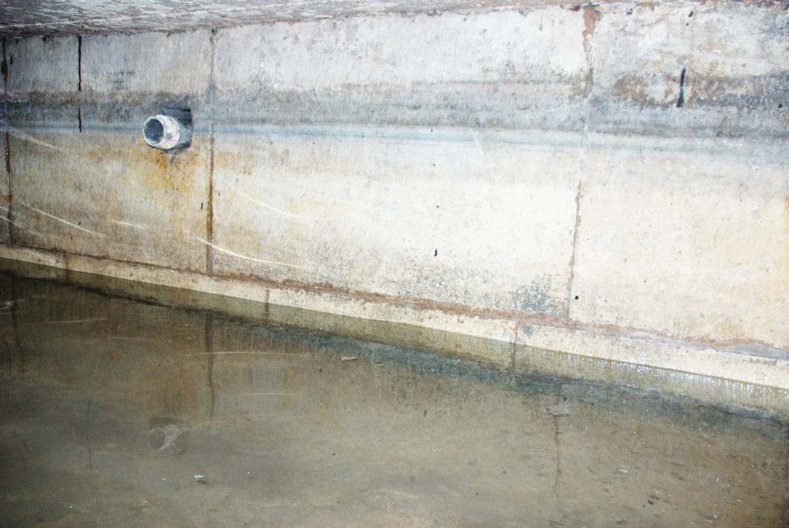
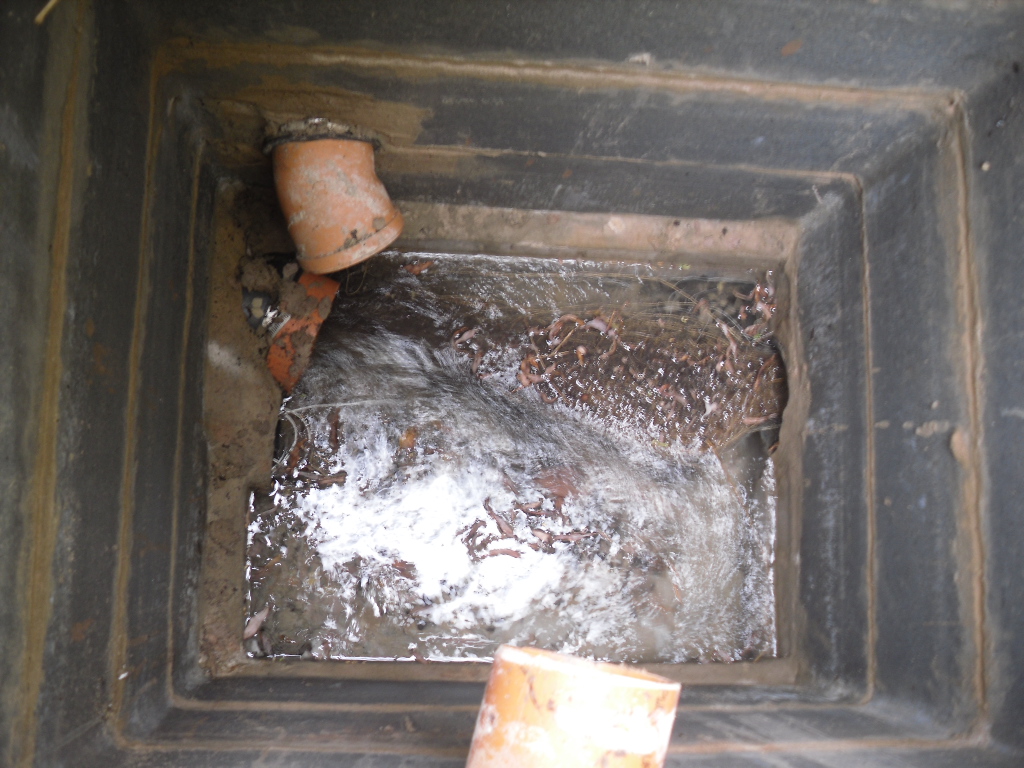
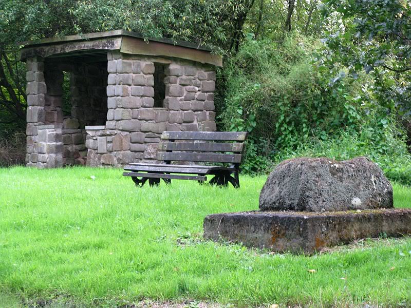
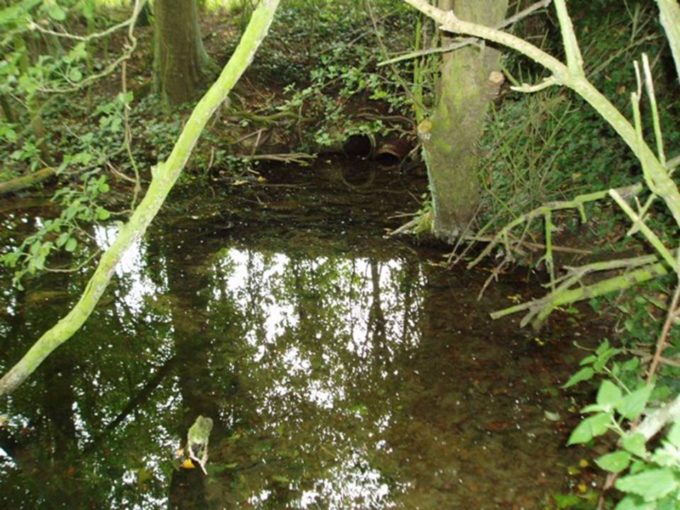
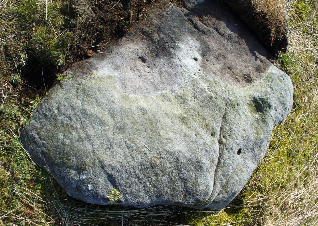
Despite the loss of the custom, the well still survives, the water clear and flowing arises beneath a stone built chamber of seven courses of stonework with a small square outlet through which the water flows.    However, according to recent reports boring in the vicinity has resulted in the water being drained away but I have been unable to ascertain this.

(Essay from the book by R.B. Parish – Holy Wells and healing springs of Lincolnshire)

References:

  1. Parish, R.B., Holy Wells and healing springs of Lincolnshire
  2. Reynolds, Jeff, Glentham Parish Council – Personal Comm.
  3. Rudkin, E.H., (1936) Lincolnshire Folklore
  4. Sutton, M., (1996) A Lincolnshire Calendar
  5. Winn, H (1888-9) in Notes and Queries

Links:

  1. Holy and Healing Wells
  2. In Search of Traditional Customs and Ceremonies

Copyright © Pixyled Publications

The map could not be loaded. Please contact the site owner.


Holy Well, Lower Burnham, Haxey, Lincolnshire

Holy Well:  OS Grid Reference – SE 785 021

Also Known as:

  1. Alley Well

Getting Here

Often noted under Lower Burnham, although this is a hamlet and not strictly the parish, is in Haxey.  The spring can be found by taking the footpath after Starkey’s farm, top of Holy Well lane, with Holy Well House the nearest dwelling.

Archaeology & History

Holy Well, Haxey
Holy Well, Haxey

Potentially if Hunt (1923) quoted in Hills (1967) is to be believed, this is the most famed holy well in the county, as he believes that this was the site where King Oswald—later St Oswald—was slain and here the well was St Oswald’s Well rather than at Oswestry. He notes that:

“The Holy Well at Lower Burnham in the parish of Haxey is supposed to mark the site where King Oswald fell. People took away the soil until a deep hole was formed which filled with water…It has been known for 1300 years as the Holy Well, and annual feasts were held near it until recent years. This confirms the Ven. Bede’s statement about the sanctity of the soil in the eyes of the people.”

According to Garner (1991) by the early 19th century the well’s popularity had waned and the spring fell into private ownership and the water was used to run two water mills, and as such a gully of considerable depth constructed. However the spring did not produce enough continuous water and the scheme failed. A similar attempt was made by Rev. Thomas Skipworth Rector of Belton was more successful but only because a dam was constructed although still the power was not great enough. Interest in the well had not completely disappeared, and an announcement in 1875, in the Epworth Bells stated:

“Firmly believing in the efficacy of the Burnham water in the cure of some outward bodily complaints, we sometime since urged the importance of making that water once more available to the public, and at the same time we urged the desirability of the public availing themselves of the water.”

Responding to this plea, a group of local men, Cooper, Starkey, Ducker, Skelton, Meggitt and Templerton came together to ‘re-open the well’ It had been for years only a dry, roughly rectangular, hollow but ‘within minutes of digging, water gushed out, and the hollow filled.’ No evidence of constructional material was seen but the landowner, Mr. Lockwood, agreed to allow the well to be kept open and the water to be freely available when he did not have cattle in the field, as such the well was fenced in probably as local people reported in the Crowle Advertiser (1960) with white railings. Indeed, up until the 1940s the well remained fenced off with barbed wire as a cattle water place and at some point it was filled in.

This meant that the well had again fallen into disused and its exact location was perhaps becoming unclear, when in the 1960s when three Epworth men, Frank and David Lindley with Jack Warriner.  A report in the Crowle Advertiser of 1960 noted that:

“At a spit depth, what seem to be known locally as water stones began to be turned up; at about two feet six there was a promising slab, followed by another, at a little deeper level; and after discovery of several hand-made bricks had dispirited the diggers somewhat, three more irregular shaped stones of considerable size were scraped clean of the mud that overlaid them. By now there was bared to view what could have been the stepped entrance to the well which from visual testimony of old residents, the explorers hoped to find.”

This stepped entrance consisted of eight steps according to local people. The group then discovered at about four feet timber was found and on this two corner stones were found rested. This was thought to have been the remains of the enclosure which went around the well.

In March 1961 another attempt was made to open the well in view of a pilgrimage by the Lincoln Diocesan Youth Pilgrimage, this time the excavators had gone twice as deep and the strata of waterstone was hit, but no evidence of a constructed well. This was not a concern of the Vicar of Owston Ferry, Canon L. D. Ravins who was of the opinion that an actual construction would have been unlikely if the above description by Hunt was to have happened. This time according to the Crowle Advertiser:

“Both he and Canon Ravins feel that the water may well have medicinal qualities (they noticed they say an unmistakably sulphurous smell from it during the excavations) and they are intending to have the chemical analysis made.”

However, the analysis did not reveal any sulphur but it did have Magnesium and Calcium sulphates and Calcium bicarbonate all linked to spa waters and hence verifying its medicinal role. The well was visited by the pilgrimage and Garner (1991) recollects that a white timber enclosure was placed around the site with a sign proclaiming ‘The Holy Well’ according to him the ‘whole site now barely discernible save for a lone willow sentinel-like over the place revered by myriad generations in days long since past.’

However, this was not the case when I visited the site and found a large pool with a pipe at one end, from which a channel appeared to flow.  Although Garner (1991) noted a ‘few elder citizens of Burnham strongly favour its position a few metres south of the spot popularly referred to”.

Folklore

However this name has not been recorded and the site is best known simply as the holy well. This site was, according to Gutch & Peacock (1908),

“ …dedicated to the ever-blessed Redeemer, and on the festival of His Ascension was supposed to possess the power of healing all sorts of deformities, weaknesses, and cutaneous diseases in children, numbers of which were brought from all parts to be dipped in it on that day.”

The earliest mention appears to be Peck (1809) who stated:

“a Spring called the Alley Well of very cold water which was very much resorted to by the people in their neighbourhood, being very proper for those of a weakly habit.”

Stonehouse (1839) notes:

“about one hundred and twenty years ago, the concourse of visitors was so great that a Village Feast was held at the same time… and at a much later period conveniences were annually made for the use of the bathers, and gingerbread-stalls and other slight reflections were provided on the spot. This practice has, however, of late years fallen altogether into disuse… The spring now appears in a dirty and neglected state.”

The fame of the spring led to it being immortalised in Hamilton’s novel Captain John Lister where the titular hero watches during the early morning of Haxey Fair, a melancholy procession through the main street of women, accompanied by diseased and deformed children. In the book, the innkeeper explains by saying:

‘They are going to the Holy Well at Nether Burnham. ‘Tis a famous spring, and has been many ages, and on this day there is virtue in the water to cure almost any disease or sickness in a child, if be dipped before noon…out of Nottinghamshire and Yorkshire and I don’t know where all.’

(Essay taken from R.B. Parish Holy Wells and healing springs of Lincolnshire)

References:

  1. Garner, J. R. (1991) Burnham – the story of an Axholme village.
  2. Gutch, E. & Peacock, M. (1908) Country Folklore Vol. VI: Folklore of Lincolnshire
  3. Hills, P.J. (1967) The Holy Well of Burnham the site of the Battle of Maserfield-the identification re-examined.
  4. Stonehouse, W.B. (1839), The History and Topography of the Isle of Axholme.
  5. Various anonymous cuttings from Crowle Advertiser (1960)

Links:

  1. Holy and Healing Wells

Copyright © Pixyledpublications

The map could not be loaded. Please contact the site owner.


Coldstone Beck, Burley Moor, West Yorkshire

Cup-Marked Stone:  OS Grid Reference – SE 143 453

Getting Here

Coldstone carving, looking S

From Burley train station, take the road uphill onto the moor edge, turning right at the top. Go on for a few hundred yards and park up round the sharp bend. Walk up the steep-ish path on the right-hand side of the rocky valley of Coldstone Beck. Once your on the level with the moors, veer to your right (west) on the footpath parallel with the walling. Barely 50 yards along, watch in the grasses and heather to your left (south).  Keep looking and you’ll find it. (apologies for just a 6-figure grid-ref for this stone, but I paid little attention to its position when I was in walkabout mode)

Archaeology & History

A couple of hundred yards east of the Cold Stone monolith is another petroglyph that has evaded the diligent archaeologists of the region!  But it’s easily missed if the daylight conditions aren’t too good.  The most notable element on the stone is the large, possibly natural cup-marking on its top-right SW side.  It’s that which initially gets your attention and, due to its initial singularity on the rock, you’d turn away and shake your head, muttering that well known petroglyphic mantra of “dunno.”  But when the sun and air are clear or low on the horizon, other more faint etchings, almost lost in the worlds of erosion, catches the eye.

Carving faintly highlighted
Looking straight down

At least four cups are visible on the stone, perhaps six, mainly near its middle and faintly highlighted in one of the images here.  But there is also a pecked carved line here too, running across the shorter northern side of the stone.  Near the bottom of this line there is the faint impression of a carved ring, but whether this is a trick of the light or real, I won’t hazard to guess.  Not far away is the curiously shaped Chair Stone and its cup-marks. Others are in the vicinity.

© Paul Bennett, The Northern Antiquarian

The map could not be loaded. Please contact the site owner.


Lichen Stone, Burley, West Yorkshire

Cup-and-Ring Stone: OS Grid Reference – SE 15065 43578

Also Known as:

  1. Dreadlocks Stone

Archaeology & History

Lichen Stone cup-and-ring
Lichen Stone cup-&-ring

This is another of the many unrecorded cup-and-ring carvings in the region—and one in a small cluster hereby.  It was rediscovered several years ago on a Northern Antiquarian outing and, thankfully, remains in good condition.  Encrusted by layers of gorgeous lichens, deep into the rock, it has hence proven difficult to explore the entirety of the exact design without tearing off the old lichen covering—which I’ve no intention of doing.

Lichen Stone, from above

There are at least a dozen cup-markings etched onto the upper surface of this curved stone, with the majority of them clustering around its eastern side.  It seems there’s only one cup-marking on the western section of the rock, with the majority of them carved near the middle of the rock and then moving to its eastern section.  But the curious features are the interlinking carved lines which you can see have been highlighted on the top and sides of the stone.  Initially you get the impression that they’re natural, but it becomes obvious the more you look at them that they’re an integral part of the carving.  Some of the lines typically link-up with other cups, whilst a number of them have been carved along and down the vertical faces of the rock, primarily on the east and north-east edges.  At least seven of them have been done and they all reach down to ground-level.

Cups & carved lines
Cups & carved lines
Carved lines highlighted

It seemed obvious that an even larger design was apparent on the rock, but the stone had been covered in an age of lichen (hence the name) which I didn’t want to disturb; and although no distinct cup-and-ring can be seen here, it looked as if one such motif might have been hiding beneath the lichen cover.  But let’s leave the rock and lichen to their own quiet life and move on our way…. to the other carvings nearby, like the impressive Fraggle Rock, or the more basic Snake Stone.  Then follow your nose and seek out the other carvings in these fields…

© Paul Bennett, The Northern Antiquarian

The map could not be loaded. Please contact the site owner.

Cold Stone, Burley Moor, West Yorkshire

Standing Stone:  OS Grid Reference – SE 14236 45433

Getting Here

Cold Stone, looking NW

From Burley-in-Wharfedale train station, take the road uphill to the moors, turning right at the top, until you hit the bend where the stream and rocky valley of Coldstone Beck appears. Walk up the right-hand (west) side of the beck until the moorland levels out.  Walk along the footpath above Stead Crag for a coupla hundred yards, keeping your eyes peeled for the largest upright stone in the heather about 50 yards into the moors. The other way is to get to Woofa Bank Enclosure and keep walking east through the heather for a coupla hundred yards till you see the tallest upright stone in the heather.

Archaeology & History

Apart from my own short entry about this site in The Old Stones of Elmet, we have no archaeological account of this standing stone, less than four feet tall and nearly as wide at its maximum, living in a landscape renowned for its excess of neolithic and Bronze Age remains.  For those of us who love our megaliths it’s nothing special — but at the same time it’s worth looking at, if only because of the other mass of prehistoric remains close by.  It received its name from the adjacent Coldstone Beck a short distance to the east, whose etymology isn’t clear.

Cold Stone, looking east
Gazing into a hazy SW

Although we know that many of the sites on this ridge are prehistoric in origin (incredibly some of it still aint registered by those who get paid to do such things), we also need to take into consideration that this site may have been effected by the early industrialists who also made their mark on this section of the moor: they have scarred some cup-and-rings along here, destroyed other remains and left incisions on some rocks which could easily be mistaken as ancient.  There is also the possibility that this upright and its adjacent stones were once part of a cairn.   If evidence comes to light that the Cold Stone is more recent, we will of course amend this site entry.

Folklore

A number of Cold Stones are found scattered across upland Britain, in the form of crags or solitary stones.  In North Yorkshire and beyond, the name is sometimes a corruption of a Call Stone, i.e., a site where village matters were called out prior to the institution of a bell-man.  The old Market Cross in Kendal village, also known as the Cold Stone was where village notices were proclaimed.

References:

  1. Bennett, Paul, The Old Stones of Elmet, Capall Bann: Chieveley 2001.

© Paul Bennett, The Northern Antiquarian

The map could not be loaded. Please contact the site owner.


Gawton’s Well, Kynpersley, Biddulph, Staffordshire

Healing Well:  OS Grid Reference – SJ 898 555

Getting Here

The Gawton Well
The Gawton Well

If you park in the first car park at Greenaway Country Park past the lake, and then walk along the road taking the footpath on the left around the lake, continue until one crosses a bridge, just below the Warden’s Tower taking a path which follows a small stream, past a pond and then continue until there is a bridge on the left.  Just after this is a path on the right you will reach the Gawton Well.

Archaeology & History

The spring, voted one of the most mystical places and certainly one of the most atmospheric of Staffordshire’s ancient wells, is found on the remains of the Kynpersley Estate.  It fills at first an elliptical stone basin, then a small rectangular basin and then a larger one which could have formed a bath.  There is a semi-circular stone just after this and it then flows through a number of large rocks forming a stream.  The site has an excellent arrangement: the juxtaposition between the man-made and the natural.

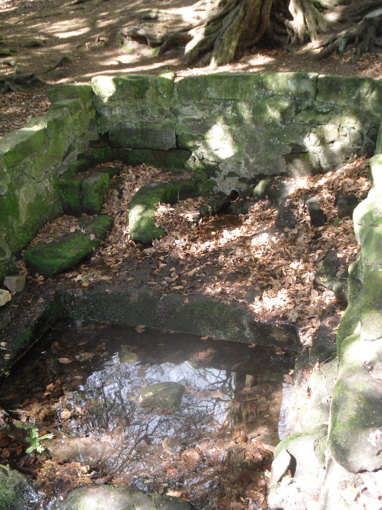
Perhaps what makes this well one of the most evocative and interesting is the fact that it arises in an oval grove of yew trees.  Some folklorists and New age Antiquarians have seen this as being evidence of some pagan origin of the well and although it is interesting that the site is unconverted to the Christian faith.  However, one must be careful.  Firstly the trees do not look that old and secondly the presence of a nearby Warden’s Tower, a folly, suggests that this is perhaps a 18th century piece of antiquarianism.  I have been unable to find much more of its history.

Folklore

The Gawton Stone
The Gawton Stone

This suggestion of the site being a folly may be justified by the presence of Gawton’s Stone. This is just up from the spring, being a large stone supported by three other stones. Some antiquarians identified erroneously this as either a druidic altar or megalithic structure (it would be impossible to lift the structure). However it is here that legendarily a hermit lived called Gawton who used the well. Often landowners would employ a hermit to add some romance to the estate, although the stone does not particularly look like a comfortable place. Certainly local tradition states that the man came from Knypersley Hall in the seventeenth century, although the house is 18th century and no name is recorded as living there of any note! The house itself dates from the 12th century. Robert Plot (1686) in his work on Staffordshire states that:

“There are many waters such as the water of the well at Gawton Stone…which has some reputation for the cure of the King’s evil..”

The King’s evil was a skin complaint generally called scrofula which was only thought to be cured by the touch of the reigning monarch.  Now rarely do I try out springs, but at this time my little boy was suffering with eczema and having tried all sorts of creams I said flippantly try some of the well’s water.  I collected it from near the source in a drinking bottle, it felt unusually silky to the skin, and applied some to an area of dry peeling skin on his cheek. Remarkably by the time we had walked from the well to the car the area have healed itself rather miraculously.  I only wished I had collected some more to use later, although the area on his face disappeared for good….

In all Gawton’s Well deserves to be more well known, a magical site of which my only clue, many years ago before the internet, to its existence before reaching it was a circle on the OS-map!  A site which may reveal its secrets with greater research, which I plan to undertake whilst preparing for the Staffordshire book below.

References:

  1. Parish, R.B., Holy wells and healing springs of Staffordshire (forthcoming) full set of references within.
  2. Plot, Robert, A Natural History of Staffordshire, Oxford 1686.

Links:

  1. Holy and Healing Wells

© R.B. Parish, The Northern Antiquarian

The map could not be loaded. Please contact the site owner.


St. John’s Well, Welham, Nottinghamshire

Holy Well: OS Grid Reference – SK 7255 8280

St John's Well house
St John’s Well house

Getting Here

One of the most unusually sited of Nottinghamshire’s holy wells is St. John’s Well at Welham. It lies beneath a private kitchen floor in a house in Bonemill Lane in Welham, just off the Clarborough Road out of Retford.

Archaeology & History

The well itself is undoubtedly an ancient one. The Domesday Book refers to ‘Wellun’; this changed to ‘Wellum’ by 1166, and by the 16th century had become ‘Wellom’; but in Chapman and Andrews map of Nottinghamshire in 1775 was shown as ‘Welham’.  None of these sources call it St John’s Well and it is not so named until 1710, either as a re-dedication once the Reformation zealouts had died down, or perhaps coined by John Hutchinson to give the bath a story to explain its healing waters.  It is shown on Chapman’s map of Nottinghamshire (1774) as ‘Well House’.  Piercy (1828) gives the greatest information and states that the hamlet of Welham was named after St. John’s Well whose waters contained magnesium and gypsum and was:

 “good for rheumatics and scorbutic diseases. Its waters formed into a large bath, and remained entire during the early part of the 18th century, it was famous for many cures, but latterly it has lost much of its celebrity.John Hutchinson, Esq. erected a cottage adjoining, and enclosed the bath, to preserve it from injury. Cold baths like this were formerly regarded with superstitious reverence, being supposed to possess a sovereign remedy for agues such as rheumatism.”

The well-cover
The well-cover
Looking into the well

By 1832 White’s Directory notes that it had lost much of its former celebrity. A Robert Walker was a bath keeper at the Well house and may well have been the last one as it appears the well soon fell into terminal decline and I can find nothing is noted of it until 1938. At this time it is noted that its water was still used to provide several cottages in the village. An article written in 1957 states the bathhouse disappeared stating the coming of the railway encouraged people to move away to find more effective spas around the 1830s. It goes on to note that the actual spring location was lost. This I thought was to be the situation, but local investigations not only showed the house to be still existence but the bath still remained! Records show that the estate, was bought by an Arthur Robert Garland of Welham Hall from the deceased estate of John Henry Hutchinson of Clarborough Hall acres117.3.16 along with Well House Cottage and garden for the sum of £3200 on in 1910. He then sold the cottage and garden to Fred Anderson on 1910 for £130. This was subsequently bought by the late Mr Eric Durham on 1955, later to be purchased by the current owner, Mr Whelan, in 1975.

st-johns-well-welham04 The present house, although it had been added onto in the last century, has its core fabric as John Hutchinson built it. The large house being the well keeper’s abode with the side building, now a modern kitchen was the bath house.  Arriving at the house, I was at first shown the site by Mr. Whelan the spring which filled the bath which was diverted to the side of the house, the spring itself arising close to the footpath behind the house. A man-hole cover in the drive way revealed that the spring flows at a fast rate, several gallons per minute. He notes that it had a very high mineral content, soaking through the gypsum in Clarborough hills. He stressed it is drinkable, in small quantities, due to its high magnesium and sulphate (like Andrews Liver Salts). It is quite chalky to taste flat but is very pleasant to drink if aerated. However he did not recommend long term drinking was probably not good for one’s health.

st-johns-well-welham05In the kitchen, a small trap door can be removed and beneath the remains of the bath is revealed. This appears to as Mee (1938) describes; a stone basin twelve feet square with a flight of steps entering the water. I scrambled down into this bath and found it presently to have two stone steps which enter the bath, although bricks built upon these suggest that there may have been more.

st-johns-well-welham06Remarkably the bath still remains enclosing an area fifteen feet by twelve feet, and despite the water being diverted, was full to over a two foot of water. The present kitchen is supported by four brick pillars but this does not appear to have damaged the fabric of the bath which is in fine condition, being made of good quality neat squared stonework. A pipe is found four feet high or so in the wall and a line around it made by the presence of water indicates that the water was of a considerable depth supporting the fact that it was large enough to be a hazard, explaining how Thomas Heald, Vicar of Babworth drowned in it on the 18th June 1759. Mr. Whelan informs me that although the house is not a listed building previous owners had sensibly preserved the bath. Around 30 years ago he was often showing local school children, but it appears now to forgotten. So there it remains a curious relic preserved in its most unusual place.

Folklore

John Piercy (1828) notes:

“Here was, until lately, a feast, or fair, held annually on St. John’s day, to which the neighbouring villagers resorted to enjoy such rural sports or games as fancy might dictate.”

What is interesting about this account is the reference of games and a fair suggesting that if the well itself did not have such a dedication, the saint was celebrated in the locale. This may indicate that indeed the well was so dedicated or that Hutchinson chose this name because of the local fair. Without further information we shall never know.

It must be noted that due to its location, under a private kitchen, that the site is not readily viewable so please don’t turn up unannounced.

References:

  1. Mee, Arthur, Nottinghamshire, Hodder & Stoughton: London 1938.
  2. Parish, R.B. (2010) Holy Wells and healing springs of Nottinghamshire
  3. Piercy, John S., The History of Retford, F. Hodson: Retford 1828.

Links:

  1. Holy and Healing Wells

© R.B. Parish, The Northern Antiquarian 

The map could not be loaded. Please contact the site owner.


Mitton Green Cross, Great Mitton, Lancashire

Mitton Gree-mapCross:  OS Grid Reference — SD 71217 39613

Also Known as:

  1. Toot Hill Cross

Getting Here

From Great Mitton village centre, take the B6246 road NW turning right up the B6243 road a quarter-mile past Great Mitton Hall.  Same distance again, and just after where the road bends left, on the same side of the road you’ll see a wooden bus-stop. The site is just on the grass next to it.

Archaeology & History

The old site by the road (after QDanT)

In a region with many old crosses hiding away in the landscape, we have very little history about this particular wayside cross and its stony base, found below the western edge of Toot Hill.  It will no doubt have had something to do with the monks of the once-prestigious Whalley Abbey a few miles away, but we know not what! The great Lancastrian historian John Dixon would, no doubt, have known something of this place, but he is sadly no longer with us… The only thing I can presently find is a passing mention in Fred Ackerley’s (1947) local history work, who told:

“Continuing along the high road past Mitton Green one sees the base of a roadside cross and directly opposite this cross-base is Toot Hill, where in ancient times it is probable that village meetings were held.”

Close-up of the cross-base, with Teddy! (after QDanT)

Toot not being a just “a look-out hill” (Smith 1954), but in some cases places where ancient temples were built, “upon high totes” — though we have no record of such a temple, christian or heathen, upon this hill.  So the reason for the stone cross at the bottom remains a mystery. Although, atop of the hill, we see marks very reminiscent of something much more archaic and heathen in nature, still visible in the crop-marks…

References:

  1. Ackerley, Frederick George, A History of the Parish of Mitton in the West Riding of Yorkshire, Aberdeen University Press 1947.
  2. Smith, A.H., English Place-Name Elements – volume 2, Cambridge University Press 1956.

Links:

  1. Pictorial Journey of East Lancashire Crosses

AcknowledegmentsBig thanks to Big Dan for use of his photos. Cheers fella!

© Paul Bennett, The Northern Antiquarian

The map could not be loaded. Please contact the site owner.


Fancarl Top, Appletreewick, North Yorkshire

Stone Circle:  OS Grid Reference – SE 06432 63048

Also Known as:

  1. Appletreewick Stone Circle

Getting Here

1st edition OS-map - the unmarked circle's near the middle
1st edition OS-map – the unmarked circle’s near the middle

Along the B6265 road between Grassington and Pateley bridge, heading east, past the hamlet of Hebden, a mile or so on where the road goes uphill, stop where it levels out a bit (before it goes further uphill to Stump Cross), a half-mile before the rocky outcrop of Nursery Knott on the left (north) side of the road.  A gate into the field on the same side is what yer after, with a small disused quarry therein.  Go up here to the quarry-top and then walk uphill for literally 100 yards and the curious small ring is right there.

Archaeology & History

Appletreewick stone circle (courtesy Paul Daw)

This small stone circle sitting on the grassy ridge overlooking the ritual rocks of Simon’s Seat and central Wharfedale to the south and the Yorkshire heathlands east and west, is probably not what it once was.  Overcome by the excess of industrial workings in the fields and moors all round here, it is probable that its present condition is far from its original state.  Indeed, if we move back to the 18th century, we find that place-name and map evidences tell us the site was a tomb.  The 1771 Greenwood map names the site as the Fancairn — an etymological curiosity in itself, possibly deriving from the ‘Windy Cairn’, which makes sense.  The place-name fell into its present title of ‘Fancarl’ after the great Ordnance Survey chaps came, heard dialect and went on their way…

The largest rock in the ring (courtesy Paul Daw)

The circle doesn’t appear to have been noted by the great Yorkshire historians Harry Speight and Edmund Bogg in their literary rambles here (rather odd), but was brought to our attention first of all (in a literary sense anyway) by Arthur Raistrick. (1965) He first “surveyed” the site in 1950, but said little until a short remark was printed in the Yorkshire Archaeological Journal, where the notes told it to be one of “two stone circles, one with clear standing stones, 30ft in diameter, and the other a double circle of small recumbent stones, 12ft in diameter.”

Ground-plan & missing stones (by Paul Daw)

The second, smaller double circle he mentions is probably a hut circle or cairn, faint traces of which are seen in the adjacent field.  Remains of a prehistoric enclosure were also once evident in the same field; and thankfully to the south (across the road) we can still find many examples of cup-and-rings at Skyreholme.

John Barnatt (1989) and Aubrey Burl (2000) include the site in their relative major surveys, with both of them citing the circle, of six small stones, to measure 8.5m by 7.5m.  The survey shown of this small stone ring was done by Paul Daw following his visit to the site on Monday 10th September 2012.

Folklore

Although we can only see six stones in this ring today, when the surveyor Paul Daw (2012) did a ground-plan of the place, he also did a dowsing survey of the site and found there were originally two extra stones on the eastern side of the circle. An archaeological dig would be interesting to see if post-holes or the remains of these two additional stones are under the turf.  He wrote:

My dowsing survey revealed that the stone circle measured 7.7 metres diameter (N-S) and 7.0 metres (E-W).  A reaction was received over the centres of stones 1, 3, 6, 7 and 8 indicating that they are still standing in their original positions, but stone number 5 to the south-south-east of the circle had a reaction at its northern end, which indicates that it was once standing but had fallen outwards. It is not therefore an earthfast stone, as speculated by A. Raistrick, when he visited the site.  The stone measures 1.65 m x 1.65 m x 800 mm and fans out like a shell from bottom to top. It would have been an impressive stone when standing, but was top heavy, and the most likely stone to fall.

Stones 1, 3, 6, and 8 are all of a similar size, are much more stable, and stand at about 500 mm high.  Stone 7 in the western sector is 800 mm high, and measures 950 mm x 850 mm, and looks like a rectangular block, with slightly rounded edges.

I also obtained a reaction at positions 2 and 4, indicating that there were once stones standing in these positions. To the north of the stone circle there are a number of stones lying on the surface.  A. Raistrick suggested that there may have been another small stone circle in this area, but my dowsing rods did not detect anything, and it is probable that these are random stones lying on the surface.

This entire region is bedevilled with faerie, goblin and giant lore, plus creation myths of our peasant ancestors (Sutcliffe 1929) — some still living if you’re lucky enough to talk with the old folk, who might tell you a thing or two, or might not, depending on how you smell.

References:

  1. Barnatt, John, The Stone Circles of Britain – 2 volumes, BAR: Oxford 1989.
  2. Burl, Aubrey, The Stone Circles of Britain, Ireland and Brittany, Yale University Press 2000.
  3. Daw, Paul M., “Appletreewick Stone Circle, Yorkshire Dales,” unpublished survey report 2012.
  4. Raistrick, Arthur, ‘Yorkshire Archaeological Register 1964: Appletreewick, W.R.,’ in Yorkshire Archaeology Journal, volume 41, 1965.
  5. Smith, A.H., The Place-Names of the West Riding of Yorkshire – volume 6, Cambridge University Press 1963.
  6. Sutcliffe, Halliwell, The Striding Dales, Frederick Warne: London 1929.

AcknowledgementsHuge thanks to Paul Daw for his photos and survey of the site, and for sharing details of his dowsing results here.

© Paul Bennett, The Northern Antiquarian

The map could not be loaded. Please contact the site owner.


Firtholme, Easington, East Yorkshire

Tumulus (destroyed):  OS Grid Reference – TA 4160 1748

Archaeology & History

In and around East Yorkshire, the fabled Yorkshire antiquarians William Greenwell and J.R. Mortimer uncovered and excavated many now-lost prehistoric tombs—some of which, beneath the rounded tumulus of earth, were constructed out of wood instead of stone.  A little-known site, now long gone, once existed in what is now the North Sea, just a few hundred yards off the Easington coast.  Other sites close by are soon to be completely swallowed back into Earth’s body, right on the water-line, but the site described here has long gone.  What little was known of it was described in Mortimer’s (1905) magnum opus, where he told:

“On the beach at Easington, in Holderness, under a tide-demolished barrow, Dr Hewetson and the writer on April 21st, 1894, discovered a double cist made of broad slabs split from the outer shell of the decayed trunk of a willow tree.  This barrow had been swept away by the waves, and its site was at about half-tide-line, and a considerable way from the very low cliffs.  Lining the grave with wood (the branches of trees) would not be difficult to accomplish and would be practised as a protection to the body.”

A henge monument and several other prehistoric barrows have been located in and around Easington, but they’re fading fast!

References:

  1. Mortimer, J.R., Forty Years Researches in British and Saxon Burial Mounds of East Yorkshire, A. Brown: London n.d. (1905).

© Paul Bennett, The Northern Antiquarian

The map could not be loaded. Please contact the site owner.