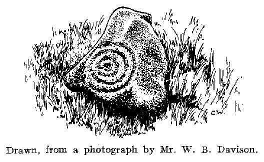
Yeavering, Kirknewton, Northumberland

Cup-and-Ring Stone (lost):  OS Grid Reference – NT 931 302

Archaeology & History

Little is now known of this carving which was described briefly by Stan Beckensall (1983):

“A cup and ring marked stone was found in the field north of Yeavering Bell in the neighbourhood of the monolith.  The last heard of it, according to the Northumberland County History (14:67) was that it was in the grounds of Ewart Park.”

The monolith he speaks of would be the one called the Battle Stone (NT 9299 3038) and Ewart Park is 2 miles ENE of here.  The carving remains lost. (the grid reference where the stone was originally located is an approximation, but a pretty good one)

References:

  1. Beckensall, Stan, Northumberland’s Prehistoric Rock Carvings – A Mystery Explained, Pendulum: Rothbury 1983.

© Paul BennettThe Northern Antiquarian

Market Cross, Glanton, Northumberland

Cross (destroyed):  OS Grid Reference – NU 0708 1445

Archaeology & History

This site has long since gone, but its existence is worthy of note.  Indeed, when Dippie Dixon (1895) wrote about it in his classic work, faded memory was all he could tell of it too, saying:

“Glanton once possessed a market cross.  Not a vestige of it now remains; but it is said to have stood about the centre of the village, on a slight knoll facing the Whittingham road…”

This would place it close to the old Red Lion pub.  Old crosses that are found at the centre of a village or township represent (albeit forgotten) the spot whence the community was born: a faded form of an omphalos, in the christian guide; later debased into little more than where markets and trade was done. When the ‘market’ wasn’t active, it was the gathering place for local people. As George Tyack (1900) told us:

“The village cross, in its more humble way, played the same part in the rustic life of its neighbourhood as did the high cross in the more bustling life of the town. Such public matters as stirred the still waters of rural existence were there discussed: the items of news from the great world without that reached the village gossips were there recounted, and the summons to the yearly Manorial Court, and other notices not suitable for procalmation in church, were there made public.”

This is the mundane function of the cross.  In its earlier status, it was the animistic symbol not only of the centre of the village, but the origin of the world itself, where moots or gatherings took place annually, calendrically, to ritually re-establish and commemorate the birth of the local tribe and their world through consecration.  But all of this has long since faded…

References:

  1. Dixon, David D., Whittingham Vale, Robert Redpath: Newcastle-upon-Tyne 1895.
  2. Eliade, Mircea & Sullivan, Lawrence E., “Center of the World,” in Encyclopedia of Religion – volume 3, MacMillan: New York 1987.
  3. Tyack, George S., The Cross in Ritual, Architecture and Art, William Andrews: London 1900.

© Paul BennettThe Northern Antiquarian


Holy Well, Bingfield, Northumberland

Holy Well (destroyed):  OS Grid reference – NZ 01 74

Archaeology & History

We add this site in the hope that a local historian may be able to rediscover its whereabouts.  Long since lost, the last account of it was mentioned in notes by the prodigious northern antiquarian John Crawford (1899) in his vast work on Northumbrian history.  Its whereabouts is vague as its final writings were scribed in The Black Book of Hexham in 1479 CE, where it was told that “the Haliwell flat (was) lying between the vill of Bingfield and Todridge.”  Mr Crawford told us it was somewhere in this area:

“The south-west extension of Grundstone Law is a tract of poor pasture land called Duns Moor; and rising opposite to it on the north-east is the Moot Law, in Stamfordham parish, the valley between being watered by an affluent of the Erring burn.”

The Well was included in Binnall & Dodds’ (1942) fine survey, with no additional notes.  To my knowledge, no more is known of the site.

References:

  1. Binnall & Doods, “Holy Wells in Northumberland and Durham – Part 2,” in Proceedings Society of Antiquaries, Newcastle-upon-Tyne, July 1942.
  2. Hodgson, John Crawford, The History of Northumberland – volume 4, Andrew Reid: Newcastle-upon-Tyne 1899.

© Paul BennettThe Northern Antiquarian


Hawklemass Well, Whittingham, Northumberland

Healing Well:  OS Grid Reference – NU 0683 1228

Archaeology & History

Hawklemass Well on 1866 map

Hawklemass Well on 1866 map

References to this site seem very scarce.  A well is highlighted on the 1866 OS-map of the region close to the spot which D.D. Dixon (1895) said it was found, “near to the Howbalk Lane end, where is also the Hawklemass Stile and Hawklemass Well.”  A stone trough could once be seen here, but its presence today needs to be confirmed by local researchers.  The site is listed in Binnall & Dodds (1943) survey, but with no additional comments to those made by Mr Dixon.

Folklore

The historian D.D. Dixon (1895) told that the village of Whittingham only had one ghost, but it was known as the “Hawklemass Ghost” and was occasionally encountered at the Hawklemass Well:

“This was a place never passed after nightfall by the youth of the village without feeling an eerie, creepy sensation, and with many a furtive glance on either side.  This unearthly visitant, in its gambols and uncanny pranks, was said to rattle the chain by which it was supposed to be bound in a fearsome manner.  It was usually seen or heard by persons who, having lingered long at the village inn, could say with Tam o’ Shanter,

“While we sit bousing at the nappy,
An gettin’ fou and unco happy,
We think na on the lang Scots miles,
The mosses, waters, slaps and styles,
That lie between us and our hame.”

One Saturday night many years ago—perhaps fifty—a poor fellow on his way from Whittingham to Glanton fel into the roadside at Hawklemass, where he was found, quite dead, the next morning by some persons on their way to Glanton meeting.  This sad affair may have given rise to the tradition of the Hawklemass Ghost.”

The name of the old lane at whose junction the Hawklemass Well once flowed, ‘Howbalk Lane’, may derive from a lost tumulus, as the word how (and its variants) regularly relate to prehistoric mounds in our more northern climes.  Such an ancient tomb, close to the well, may be the origin of the ghost story.

References:

  1. Binnall, P.B.G. & Dodds, M.H., “Holy Wells in Northumberland and Durham – part 2”, in Proceedings of the Society of Antiquaries Newcastle-upon-Tyne, 10:2, 1943.
  2. Dixon, David Dippie, Whittingham Vale, Northumberland, Robert Redpath: Newcastle 1895.

Acknowledgements:  With thanks to Gill Rutherford for prompting me to finish this; and to Claire Heron for the OS-map reference.

© Paul BennettThe Northern Antiquarian


Fairy Stone, Fourstones, Northumberland

Legendary Stone:  OS Grid Reference – NY 893 680

Archaeology & History

Thought to have been destroyed in the 19th century, folklorists and historians alike didn’t seem to be able to locate this little-known folklore relic, which is still alive and well in one of the fields by the village.  The exact nature of the stone isn’t known for certain.  Legend reputes it to have been one of the four boundary stones which gave the village its name; it was also said that they were Roman altars and the Fairy Stone was one of them, which was moved from the village boundary during the Rebellion of 1715 and placed nearer the centre.

Folklorist M.C. Balfour (1904) seemed to think that stone had gone when he wrote about it.  Writing about it in the past tense, he told,

“The Fairy Stone however, certainly had an existence, for a person, 80 years of age, remembered its situation to the south of the village, near the old road, and that it was squared, and had a square “cistern hewn out of its top,” which was called the Fairy Trough, and traditionally said to have had a pillar fixed in it.”

But when former Ley Hunter editor Paul Screeton (1982) came looking for the stone in the late 1970s, he was fortunate in coming across an old local:

“Some time ago while looking for the Fairy Stone at Fourstones…I came across a farmer who pointed it out and remarked that a few years previously when the road was widened the local lengthsman made sure it was not destroyed, though it had to be moved a short distance.”

Folklore

Of the four boundary stones surrounding the village, they were “supposed to have been formed to hold holy water,” said Balfour (1904).  But the title Fairy Stone given to one of them had this tale to account for it:

“A couple of miles or more down the South Tyne is Fourstones, so called because of four stones, said to have been Roman altars, having been used to mark its boundaries. A romantic use was made of one of these stones in the early days of “The Fifteen.” Every evening, as dusk fell, a little figure, clad in green, stole up to the ancient altar, which had been slightly hollowed out, and, taking out a packet, laid another in its place. The mysterious packets, placed there so secretly, were letters from the Jacobites of the neighbourhood to each other; and the little figure in green was a boy who acted as messenger for them. No wonder that the people of the district gave this altar the name of the ‘Fairy Stone’.”

References:

  1. Balfour, M.C., Country Folk-lore volume 4: Examples of Printed Folk-lore Concerning Northumberland, David Nutt: London 1904.
  2. Screeton, Paul, “The Long Man of Wilmington,” in The Ley Hunter, no.92, 1982.
  3. Terry, Jean F., Northumberland Yesterday and Today, Andrew Reid: Newcastle 1913.
  4. Watson, Godfrey, Northumberland Place Names, Sandhill: Morpeth 1995.

Acknowledgements:  Big thanks to Paul Screeton for the grid-reference!

© Paul BennettThe Northern Antiquarian


Barrasford Common, Barrasford, Northumbria

Settlement:  OS Grid Reference – NY 9212 7538

Also Known as:

  1. Toddle Crags Settlement
  2. Gunnerton Settlement

Archaeology & History

Aerial view of settlement, 1967 (courtesy, Antiquity journal)

Some of the extensive remains of an Iron Age settlement on the northeastern edges of Barrasford Common, on the edge of Toddle Crags a couple of miles north of Chollerton, are thankfully still visible, despite the increased quarrying operations taking their toll on other (now lost) prehistoric sites between the little villages of Gunnerton and Great Swinbourne.  The remains of earthworks and walling are clearly visible at ground level, despite being overgrown.

The archaeologist J.K. St. Joseph (1970) described them in a short piece in Antiquity journal more than 40 years ago, saying:

“The site as first described by the reverend G. Rome Hall (1876) in the course of a survey of settlements around Birtley and Barrasford, made a century ago.  It is the easternmost of three settlements that he noted on the crags east of Gunnerton, and his sketch-plan shows rather irregular enclosures within which appear a dozen hut-circles, between 27ft and 15ft…in diameter according to his account.  The western of the three settlements was subsequently excavated by Rome Hall about 1880, and re-examined in 1941 by Mr A.H.A. Hogg (1942), who was able…to show that the period of occupation fell within the Roman Age. Mr Hogg refers to the earthworks illustrated (above) as ‘a very large settlement, much robbed.’

“…The site consists of a roughly square enclosure, 300ft across, or a little more, defined by a low bank… The SW and SE sides are straight: on the other two sides the boundary mark conforms to the cont0urs of the ground.  The enclosure is subdivided, and evident traces of hut circles and of more rectangular-shaped buildings are still to be seen.  Some of the small compounds may be pens for stock, and the general impression conveyed by the earthworks is of a settlement that has developed over a period of time, additions and rebuildings being involved.  It is thus a notable example of the rectangular settlements of the Roman Iron Age, which occur widely in south Northumberland, as Mr G. Jobey has demonstrated.  The earthworks compare well in point of weathering, at least in an aerial view, with the best preserved of the Iron Age settlements on the moors in the north of the county.”

The writer notes how the this settlement had evidence of continued human use all the way from the Iron Age to perhaps as late as the 18th century!  This isn’t too unusual.  The best example I’ve yet to come across is the little-known settlement complex in the far north, on the small plateau known as Baile Mhargaite near Bettyhill, Sutherland, where a living community began in the neolithic period and only came to an end with the Highland Clearances two hudnred years ago!

References:

  1. Hall, George Rome, “Ancient British Remains near Birtley and Barrasford, North Tyne,”  in Archaeologia Aeliana, Volume 7, 1876.
  2. Hogg, A.H.A., “The Native Settlement at Gunnar Peak,” in Archaeologia Aeolina, Volume 20, 1942.
  3. St. Joseph, J.K., “Air Reconnaissance: Recent Results 19,” in Antiquity no.173, March 1970.

ACKNOWLEDGEMENTS:  Many thanks to Antiquity Journal for use of the photo.

© Paul Bennett, The Northern Antiquarian 


Pike Hill, Stamfordham, Northumbria

Cup-and-Ring Stone:  OS Grid Reference – NZ 0774 7048

Archaeology & History

1928 photo of carving

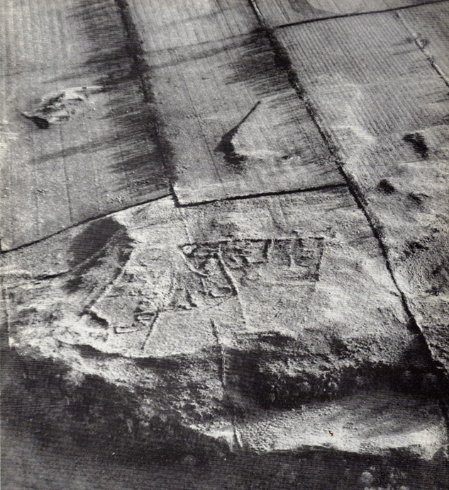
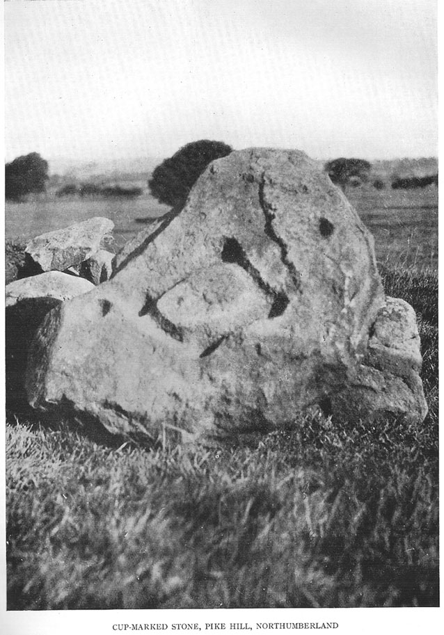
Found inside a prehistoric tomb that was excavated in the late 1920s “by Messrs R.C. and W.P. Hedley at Pike Hill, near Stamfordham,” this fascinating-looking carving was found on a stone that “was overlying the primary burial” cist in the middle of the tumulus, measuring “2 feet 9 inches long by 2 feet wide and 12 inches deep, with an orientation on the longer axis of NE.”  As we can see in the old photo that accompanied Mr Hedley’s (1928) short article in Antiquity journal, four single cups are arranged in a rough square and are joined with each other by a single line, running from cup to cup, outlining a clear quadrilateral formation.  Two other single cups are outliers on the left and right side of the ‘square.’

A second smaller cist was also found inside the same mound and on the central inner face of this was another, more simplistic carving described as “a very fine cup-mark 1½ inch in diameter and ¾-inch deep.”  These carvings are no longer in situ (I think they’re in Newcastle Museum) and apparently this second single cup-marked stone can no longer be located.

References:

  1. Beckensall, Stan, Northumberland’s Prehistoric Rock Carvings, Pendulum: Rothbury 1983.
  2. Beckensall, Stan, Prehistoric Rock Motifs of Northumberland – volume 2: Beanley to the Tyne, Abbey Press: Hexham 1992.
  3. Hedley, R. Cecil, “Ancient British Burials, Northumberland,” in Antiquity Journal, volume 2, December 1928.

© Paul Bennett, The Northern Antiquarian

Lee Hall Well, Bellingham, Northumberland

Healing Well:  OS Grid Reference – NY 861 797

Archaeology & History

Very little is known about this forgotten heathen water source.  It was described in some notes attached on a piece of paper accompanying John Warburton’s description of Lee Hall and its surroundings.  The notes were first printed in an early edition of Archaeologia Aeliana and subsquently included in Binnall & Dodds’ (1942) fine survey on the holy wells of the region.  It’s exact whereabouts appears to be lost, and may be either the small pool across from the present Hall, or a small spring found in the edge of the small copse of trees just east of Lee Hall Farm. Anyone know for sure?

Folklore

Written verbatim in that dyslexic olde english beloved of old folklorists like misself, the only bitta folklore said of this spring of water told:

“At the Lee hall an exclent spring, the vertue is such that if the lady of the Hall dip aney children that have the rickets or any other groone destemper, it is either a speedy cure of death.  The maner and form is as followeth: The days of dipping are on Whitsunday Even, on Midsumer Even, on Saint Peeter’s Even.  They must bee dipt in the well before the sun rise and in the River Tine after the sun bee sett: then the shift taken from the child and thrown into the river and if it swim…child liveth, but if it sink dyeth.”

The latter sentence echoing the crazy folklore of the christians to identify witches in bygone days!

References:

  1. Binnall, P.B.G. & Dodds, M. Hope, ‘Holy Wells in Northumberland and Durham,’ in Proceedings of the Society of Antiquaries of Newcastle-upon-Tyne (4th Series), 10:1, July 1942.

© Paul Bennett, The Northern Antiquarian

Crowbar Stone, Weetwood Moor, Wooler, Northumbria

Cup-and-Ring Stone:  OS Grid Reference – NU 021 278

Also known as:

  1. North Plantation 3
  2. Fowberry Moor Stone 3

Archaeology & History

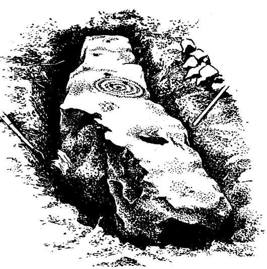
Davison’s sketch

This is an excellent-looking carving which, it would seem, remains buried in the Earth nice n’ sleepy!  Located “in the inner rampart on the south side of an unrecorded camp in North Plantation, Fowberry Moor, Chatton,” the carving was unexpectedly found during some basic excavation work on the camp itself.  Described and illustrated by W.B. Davison (1934), this was one of two cup-and-ring stones hereby.  He reckoned it wasn’t in its original position and seems – from the illustration here – to have been etched onto a fallen monolith.  Davison’s detailed description told:

“The…stone was completely excavated and was found to be built into the inner rampart across its track.  This stone measures 7’6″ north to south, is 1’2″ wide at its north end, 1’11” at its widest part, and 1’3″ at its foot.  The average depth is 2’6″.  The base is rough-surfaced and is prow-shaped at the northern end.

“Incised markings occur on the top only, and are as follows, reading from north to south.  1 cup surrounded by a ring and a half-ring lying east to west by south.  1 small cup.  1 cup.  1 cup surrounded by four rings, the largest of which has a diameter of 13½”.  On the top of the outer ring occurs an abutting semicircle enclosing a cup.  On the accompanying (image) will be observed what appears to be another cup on the innermost ring.  1 cup.  1 cup surrounded by a ring and a half-ring lying north to south by west.  This marking rests on a two-inch deep slot possibly made for quarrying purposes.  No other markings occur between this slot and the foot of the stone.  Tool marks are very distinct on some of the above markings.”

Rock art researchers Jan Brouwer (2007) and Stan Beckensall have searched unsuccessfully for the stone in recent years.

References:

  1. Beckensall, Stan, Northumberland’s Prehistoric Rock Carvings, Pendulum: Rothbury 1983.
  2. Beckensall, Stan, Prehistoric Rock Art in Northumberland, Tempus: Stroud 2001.
  3. Brouwer, Jan, ‘In Search of the Crowbar Stone,’ BRAC 2007.
  4. Davison, W.B., ‘Cup-and-Ring Marked Rocks at Fowberry Park,’ in Proceedings of the Society of Antiquaries of Newcastle-upon-Tyne (4th Series), 4:7, October 1934.

© Paul Bennett, The Northern Antiquarian
Fowberry Moor Farm, Wooler, Northumberland

Cup-and-Ring Stone:  OS Grid Reference – NU 029 261

Also known as:

  1. Deershed Plantation Stone

Archaeology & History

This is a small but impressive stone, presently housed in the Musuem of Antiquities in Newcastle.  It was first mentioned by Mr H.L. Honeyman (1934) as being donated to Newcastle’s Society of Antiquaries by a Mr J.M. Strother of Fowberry Moor Farm in 1934.  He described the carving as,

“a sculptured ring-marked stone, 1ft 2in by 1ft 2in, bearing a cup with three rings and duct. Found in Island Plantation (camp), Fowberry Moor, Chatton, 22.7.34, by Mr Wake.”

Stan Beckensall (1983:127) described it in passing his early work on Northumberland rock art, then again in his updated edition.

References:

  1. Beckensall, Stan, Northumberland’s Prehistoric Rock Carvings, Pendulum: Rothbury 1983.
  2. Beckensall, Stan, Prehistoric Rock Art in Northumberland, Tempus: Stroud 2001.
  3. Honeyman, Herbert L., ‘The Society’s Meetings: July,’ in Proceedings of the Society of Antiquaries of Newcastle-upon-Tyne (4th Series), 4:7, October 1934.

© Paul Bennett, The Northern Antiquarian